Scenic Map Grand Canyon App Reviews
Scenic Map Grand Canyon App Description & Overview
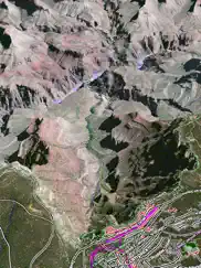
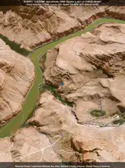
What is scenic map grand canyon app? Explore the rich landscapes around the Grand Canyon and Arizona while you discover Scenic Map, the best 3D topo map for the iPad and iPhone. The vector map data is contained within the app and can be used without an internet connection. Use it in a car, a boat, a plane or while hiking.
Online satellite image overlays add breathtaking detail and realism to the maps (tap preset 2 or 4 when Online Map is enabled). You can use them as you travel to see what is hidden from view at ground level. This takes moving maps to a whole new level. With an in-app purchase you can expand the coverage to the entire world via the Scenic Map online map and cache the data for offline use.
Use the two finger vertical swipe gesture to tilt the map for a 3D view. Scroll like a map or fly like a flight simulator. Enable Joystick Gestures in the Settings menu and then fly around the terrain using a virtual joystick. Prefer only 2D maps? Enable the 2D Map option in the Settings menu.
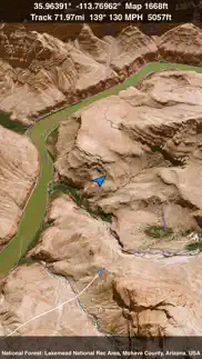
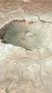
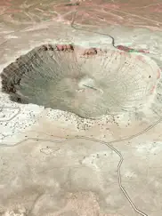
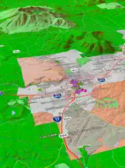
Scenic Map is simply the best 3D topo map available for a mobile device. You will see incredible detail while scrolling, rotating and zooming perfectly smoothly. You will see every road even if you zoom out to the altitude of a satellite. As you zoom in, you will see every small bump and hollow of the Earth and terrain features as small as ten meters. Unlike old fashioned topo maps, Scenic Map’s roads and trails are up to date thanks to OpenStreetMap.org. It contains polygons for urban areas, shopping malls, an ever growing number of buildings and many other features, The best lake, pond, stream and rivers from the USGS and Canadian public databases are also included.
Tap the GPS center button to begin tracking your location. As you move, you will generate a track file. Tracks can be replayed with video like controls to speed up, slow down, pause, restart or skip to the end. You can display existing tracks while recording another if you want to retrace your route. When online, you can automatically create a route from your current GPS location to any other point on the map. Tracks can be received from or sent to other apps in GPX format. GPS recording stops automatically after you have remained stationary for some time or you can choose to manually stop tracking by tapping on the top track in the Tracks view.
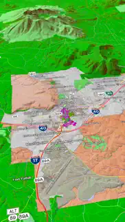
Never before have maps been this customizable. For example, you can turn on or off the roads. You can change the lighting direction or remove terrain shading entirely. You can display contour lines even over satellite images. There are five presets which let you quickly switch between map styles. Use Metric, English or Nautical units and choose one of four different coordinate displays including UTM.
Want to learn more about a map feature? Tap the target icon and center the feature under the compass rose to display its name, type, urban area, county, state, elevation and coordinates. You will also see a bearing line back to your current GPS location or from your location to a selected waypoint. The status bar shows the bearing direction and distance along with the map and GPS elevation, the track length, and your current speed and direction of travel.
In-app documentation is provided in the Help section at the top of the Settings menu. Links are provided in the documentation to detailed coverage maps, tutorial videos, installation guide and blog at ScenicMap.com
Map data © OpenStreetMap and contributors under the Open Database License
Scenic Map supports GPS tracking while the app is in the background.
Caution: Continued use of GPS running in the background can dramatically decrease battery life.
😍 Do you love Scenic Map Grand Canyon app? Please share your friends!

Please wait! Scenic Map Grand Canyon app comments loading...
Scenic Map Grand Canyon 1.9.2 Tips, Tricks, Cheats and Rules
What do you think of the Scenic Map Grand Canyon app? Can you share your complaints, experiences, or thoughts about the application with GrangerFX and other users?
Scenic Map Grand Canyon 1.9.2 Apps Screenshots & Images
Scenic Map Grand Canyon iphone, ipad, apple watch and apple tv screenshot images, pictures.
| Language | English |
| Price | Free |
| Adult Rating | 4+ years and older |
| Current Version | 1.9.2 |
| Play Store | com.grangerfx.ScenicMapGC |
| Compatibility | iOS 16.1 or later |
Scenic Map Grand Canyon (Versiyon 1.9.2) Install & Download
The application Scenic Map Grand Canyon was published in the category Navigation on 01 April 2010, Thursday and was developed by GrangerFX [Developer ID: 363698835]. This program file size is 67.38 MB. This app has been rated by 2 users and has a rating of 5 out of 5. Scenic Map Grand Canyon - Navigation app posted on 19 January 2024, Friday current version is 1.9.2 and works well on iOS 16.1 and higher versions. Google Play ID: com.grangerfx.ScenicMapGC. Languages supported by the app:
EN Download & Install Now!| App Name | Score | Comments | Price |
| Blue Hound Reviews | 4.6 | 717 | $1.99 |
| Scenic Map Central Canada Reviews | 1 | No comment | $3.99 |
| Scenic Map Eastern USA Reviews | 5 | 6 | $4.99 |
| Scenic Map Central USA Reviews | 4.7 | 4 | $4.99 |
| Scenic Map Reviews | 4.6 | 3 | Free |
Fixed track recording in iOS 17. Fixed the settings menu in landscape mode on iPhone. Fixed low frame rate when the information bar is enabled. The map's highest detail is now displayed while scrolling.
| App Name | Released |
| Speedometer Simple | 18 November 2014 |
| Find My Friends Phone - iMapp | 26 July 2014 |
| Blink Charging Mobile App | 08 October 2022 |
| Footpath Route Planner | 07 May 2013 |
| Find my Phone - Family Locator | 08 January 2013 |
Find on this site the customer service details of Scenic Map Grand Canyon. Besides contact details, the page also offers a brief overview of the digital toy company.
| App Name | Released |
| Solocator - GPS Field Camera | 09 December 2012 |
| MapOut | 19 March 2012 |
| NavRules | 07 March 2011 |
| Land Nav Assistant | 18 May 2012 |
| Exit Strategy NYC Subway Map | 07 July 2009 |
Discover how specific cryptocurrencies work — and get a bit of each crypto to try out for yourself. Coinbase is the easiest place to buy and sell cryptocurrency. Sign up and get started today.
| App Name | Released |
| 28 April 2011 | |
| Telegram Messenger | 14 August 2013 |
| Amazon Shopping | 03 December 2008 |
| TikTok | 02 April 2014 |
| CapCut - Video Editor | 14 April 2020 |
Looking for comprehensive training in Google Analytics 4? We've compiled the top paid and free GA4 courses available in 2024.
| App Name | Released |
| Bloons TD 5 | 15 November 2012 |
| The Past Within | 02 November 2022 |
| TV Cast Pro for LG webOS | 23 June 2016 |
| AutoSleep Track Sleep on Watch | 19 December 2016 |
| HotSchedules | 30 October 2008 |
Each capsule is packed with pure, high-potency nootropic nutrients. No pointless additives. Just 100% natural brainpower. Third-party tested and validated by the Clean Label Project.
Adsterra is the most preferred ad network for those looking for an alternative to AdSense. Adsterra is the ideal choice for new sites with low daily traffic. In order to advertise on the site in Adsterra, like other ad networks, a certain traffic limit, domain age, etc. is required. There are no strict rules.
The easy, affordable way to create your professional portfolio website, store, blog & client galleries. No coding needed. Try free now.
Scenic Map Grand Canyon Comments & Reviews 2024
We transfer money over €4 billion every month. We enable individual and business accounts to save 4 million Euros on bank transfer fees. Want to send free money abroad or transfer money abroad for free? Free international money transfer!
Limited use. Next time I go back there I need to have the shuttle routes and schedules serving the various lookouts, and why not also thumbnail images/video clips so people can decide whether or not to stop there or hurry to the eastern side of GRAND CANYON or perhaps get something to eat...now that's the app i'll keep
Huh?. Really not very useful. A lot of space for little benefit. Also it boasts no need for Internet, but, it would be better to use other tools for research and map use of these areas. This simply gives very little for the space it takes.. Sorry.
Disappointed. The maps are virtually useless: 1- the text used is far too large and does more to obstruct the view than it does to help. 2- all the text is oriented horizontally and oversized leaving you to guess at which text goes with which street. 3- The "buildings" shown on the maps are little more than sat view outlines with no reference or naming for parks, malls, etc. 4- The paid versions offer no benefit over the free maps so download the free first, If those serve your purpose, you may be ok with the substantially overpriced paid versions of this app. DISAPPOINTED
Fascinating. To the previous brilliant reviewer...I care about dessert as it's my favorite part of a meal. As for the desert, if you've been to desert locales and/or are fascinated by maps and topography, you'll find these views extremely interesting. Now you can tell what's behind that inaccessible hill or mesa that you always wondered about. These maps would be great for hikers or riders plotting a course for business or pleasure. I just wish you had more New Mexico locales. Well worth the price.
Apps like this are why I love my iPad. For hikers and campers, I can't imagine how it could get better than this. It's a massive, extremely detailed map, crammed into your iPad! I suspect that whatever people were complaining about before, is long gone now. Because the whole Scenic Map series has been very responsive on my iPad. This is absolutely a game changer. It's very fast, very responsive, and has a clean, simple interface. The clutter-free UI is vital when you're carrying a heavy backpack, and you're in unfamiliar territory. The fact that it's completely self-contained makes this a million times better for actual campers than any server side app could ever be. I can take these Scenic Map apps with me, and I've got a permanent, complete map of every place I could possibly want to stop at, right there on my iPad, even if I can't get a cell phone signal (or much less find a wi-fi hotspot). Now if the idea of a hiking destination that doesn't have 3G coverage sounds uncivilized to you, this might not be the app for you. And you should probably stay inside the city limits, where it's safe. This is the first decent replacement for a map I've seen on the platform, and it works great. Very fast. Very easy. Very responsive. I have no problem recommending this to everyone. It's a no-brainer for anyone who spends any amount of time outside. And this one's free! But even for the others, even at $10 a pop, they're a hell of a lot better deal than any of the paper and plastic maps I've bought in the last ten years. Great job, GrangerFX!
Scenic Map Grand Canyon. This is one of the most fantastic topo map programs I've ever used, and it is on my cellphone. If I only had this 40 years ago when I started backpacking. Roll Tide Roll!
El Crapola. Worthless as it stands with bad maps in limited areas with poor lettering and lousy graphics and repeated ad-cluttered pitches to upgrade, What's not to like??? Sometimes I think app developers are geniuses and sometimes, like these guys, are just either incompetent or con artists. Don't even give them the dignity if your click on. Sorry I did.
Very cool. I like it. Alot of attention went into the details. Unfortunatley the iPhone screen is so small it's hard to appreciate the true potential of this app. I've been to the canyon and 3g isn't an option so loading could be an issue. But all things considered, including the price (FREE), it's a nice app.
Better than trying to fold those gas station maps back up to fit in the glove compartment. To answer Mark's question, it's 256Mb. Suggest you check your internet connection. Took me about 3 minutes to download and 1 minute to install. After playing with this for a while I'm sure there is more here than most people would ever use. Even on a trip to the Grand Canyon this would give you enough info to make your trip way more enjoyable. All the places that people never get to. Hell, I'm going this spring. See ya there.
Works great!. It took less than 30 seconds to download over WiFI. My 3G data plan does not allow downloads over 20MBs. That might be the other reviewers issue. I especially like the two finger map rotation. Really nice and extremely fast rendering engine in this app!
Waste of time. Who cares about the dessert this app is lame
AWESOME,this app blows me away. AWESOME,this app blows me away I i downloaded and used the GRAND CANYON map and it contained so many obscure little off the beaten path roads that i like to explore. For example check out JOHNS CANYON ROAD north west of MEXICAN HAT, UTAH this dirt road is in the middle of no where and in some spots is a white knuckle-r to drive it starts out high clearance two wheel drive then ends in 4wd, and here it is in this app start to finish. I was so impressed with the amount of detail , and the topo terrain and shading, that I decide to upgrade to the complete WESTERN STATES map and I was amazed to see that a new road here in south Orange County, Ca. that was just built last year and it is included in the Western states version, (talk about up to date). Yes the app takes a good chunk of memory so i had to delete a bunch of useless & ridiculous apps, videos, music and photos in my IPHONE 3G but but for me it is well worth having all this useful map data & info on the device, and not have to worry about WiFi or a cellular network where i go camping that stuff just doesn't exist. It was well worth the money spent. I use it with an IPHONE 3G paired to a DUAL XGPS 150A Bluetooth receiver , and it screams, the topo terrain renders and transitions from one map area to another is flawless, also the birds eye view with a little bit of angle to put your perspective behind the position cursor is real nice.
Start Here. I tried out this App, and within days had purchased the full Eastern version. See my extended comments there. Get the one for where you live.
Won't download 1.51. Can't use this this product since it won't download and install 1.51 even on a new purchase.
Sad. Terrible UI, non-responsive interface... Too bad, because apps like this could be very cool. Yes, it works, but it's very poorly done.
Did you know that you can earn 25 USD from our site just by registering? Get $25 for free by joining Payoneer!
Imagine you at your best. All the time. Picture yourself at your sharpest and most productive. Your most alert and focused. Your most lucid, creative and confident. At work. At play. In every area of your life. Add Mind Lab Pro® v4.0 to your daily routine and uncap your true potential. Buy Now!
Useless. A whole lotta megabytes for a whole lotta nothing. I just went to the Grand Canyon. The best guide was a printed book about Arizona by AAA.
Adsterra is the most preferred ad network for those looking for an alternative to AdSense. Adsterra is the ideal choice for new sites with low daily traffic. In order to advertise on the site in Adsterra, like other ad networks, a certain traffic limit, domain age, etc. is required. There are no strict rules. Sign up!