MapOut App Reviews
MapOut App Description & Overview
What is mapout app? “MapOut saves the day with its intuitive interface for drawing routes and viewing elevation profiles. I’m genuinely impressed by its powerful features!” – Alee, cyclingabout.com
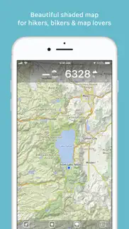
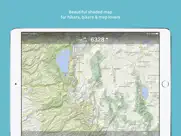
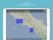
Offline maps covering the entire globe, optimized for iPhone and iPad. As beautiful as a traditional paper map—but far more versatile.
Perfectly tailored for:
- Hikers: Clear, detailed terrain maps accessible even in the most remote locations, without an internet connection.
- Cyclists: Extensive cycling route network with real-time speed and distance tracking.
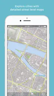
- City Travelers: Detailed city maps complete with essential tourist information.
- Map Enthusiasts: Simply elegant maps that are a pleasure to view.
Innovative 3D Tilt View
- Tilt your device in any direction to vividly explore terrain details. Learn more at [mapout.app](https://mapout.app).
Powerful Offline Search
- Easily find places, streets, mountains, and more—no internet needed.
High-Quality Map Data
- Built upon the OpenStreetMap project, the "Wikipedia of Maps". Contribute your own corrections and additions at OpenStreetMap.org.
- Regularly updated offline maps available for your selected regions.
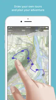
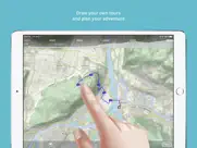
Effortless Tour Planning
- Draw: Easily create custom routes and waypoints directly on your map. Adjust existing tours or imported GPX files effortlessly.
- Import: Transfer routes to your device via email using a free "MapOut.me" account. Discover countless GPX and KML route files online, ideal for hiking or biking (e.g., gpsies.com).
- Record: Capture your adventures and easily share them with friends.
- Insights: Quickly see vital information for every tour—distance, elevation changes, route profile, and map details.
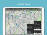
Superior Map Viewing Experience
- Rapid, hardware-accelerated rendering for smooth navigation.
- Continuous zoom with impeccable clarity at every level.
- Detailed topographical views featuring contour lines and shading.
- Versatile overlays include biking, hiking, skiing routes, sightseeing locations, and public transport networks.
Find comprehensive support and answers in our user manual: https://mapout.app/manual
Map data © OpenStreetMap contributors https://www.openstreetmap.org/copyright
😍 Do you love MapOut app? Please share your friends!

Please wait! MapOut app comments loading...
MapOut 3.4.13 Tips, Tricks, Cheats and Rules
What do you think of the MapOut app? Can you share your complaints, experiences, or thoughts about the application with Valnova and other users?

MapOut 3.4.13 Apps Screenshots & Images
MapOut iphone, ipad, apple watch and apple tv screenshot images, pictures.
| Language | English |
| Price | $4.99 |
| Adult Rating | 4+ years and older |
| Current Version | 3.4.13 |
| Play Store | ch.valnova.MapOut |
| Compatibility | iOS 11 or later |
MapOut (Versiyon 3.4.13) Install & Download
The application MapOut was published in the category Navigation on 20 March 2012, Tuesday and was developed by Valnova [Developer ID: 312297700]. This program file size is 71.33 MB. This app has been rated by 134 users and has a rating of 4.9 out of 5. MapOut - Navigation app posted on 27 May 2025, Tuesday current version is 3.4.13 and works well on iOS 11 and higher versions. Google Play ID: ch.valnova.MapOut. Languages supported by the app:
EN FR DE Download & Install Now!| App Name | Score | Comments | Price |
- fixed bug in dashboard
| App Name | Released |
| KakaoMap - Korea No.1 Map | 27 February 2009 |
| Passio GO | 06 May 2017 |
| Divvy Bikes | 16 May 2018 |
| PlugShare | 07 March 2011 |
| Earnify | 22 May 2024 |
Find on this site the customer service details of MapOut. Besides contact details, the page also offers a brief overview of the digital toy company.
| App Name | Released |
| Theodolite | 30 November 2009 |
| NavRules | 07 March 2011 |
| Tactical NAV | 14 February 2011 |
| GPX Viewer PRO | 05 February 2020 |
| Omaha Zoo - ZooMap | 19 August 2023 |
Discover how specific cryptocurrencies work — and get a bit of each crypto to try out for yourself. Coinbase is the easiest place to buy and sell cryptocurrency. Sign up and get started today.
| App Name | Released |
| YouTube TV | 05 April 2017 |
| 07 April 2016 | |
| Telegram Messenger | 14 August 2013 |
| 09 October 2009 | |
| DoorDash - Food Delivery | 10 October 2013 |
Install the Giftmio extension for smart shopping. Get notified about cashback opportunities, activate cashback in one click, and save money on purchases.
| App Name | Released |
| Terraria | 28 August 2013 |
| RadarScope | 12 February 2019 |
| Slime Rancher | 26 May 2026 |
| CloverPit | 17 December 2025 |
| Incredibox | 27 March 2016 |
Each capsule is packed with pure, high-potency nootropic nutrients. No pointless additives. Just 100% natural brainpower. Third-party tested and validated by the Clean Label Project.
Adsterra is the most preferred ad network for those looking for an alternative to AdSense. Adsterra is the ideal choice for new sites with low daily traffic. In order to advertise on the site in Adsterra, like other ad networks, a certain traffic limit, domain age, etc. is required. There are no strict rules.
Keep personal info private, avoid scams, and protect yourself online with AI-powered technology.
MapOut Comments & Reviews 2026
Decent app. Decent app, good detailing and till view is more useful than I originally thought it would be. Huge downside: developers please add the ability to tag and label locations for future reference.
Almost perfect. I do a lot of driving on backroads, and this is the best app I’ve used for downloading offline maps, and recording tracks. Simple and clean user experience. Would be perfect (5 stars) if it had CarPlay support.
Outstanding app. This app is outstanding. The best map app I have…. Nothing else comes close.
Worked great on 5 week Ireland-France bike tour. Used the app extensively for self guided bicycle tour. It worked great. Made route planning very easy as well as following and adjusting the routes.
Good app with vector maps. Pros: Awesome smooth vector maps with OpenStreetMap data! Cons: there are POIs displayed from OSM, but from a very few categories. Data is not loaded from OpensStreetMap servers but updated regularly
Beautiful!. Gorgeous graphics and fantastic user interface. Buy this if you live or spend time in Switzerland!
MapOut is awesome. Who need to buy a Garmin when mapout does so much? Heading to Italy for a five week tour and plan to use mapout on my iPhone. Downloading gpx files is so incredibly easy too. Routes are easy to organize into folders. I don’t see a reason to have any other map program.
The best app for Swiss maps. I bought this app after arriving in Switzerland and needing some form of offline maps for the bike touring and hiking I had planned. 1.5 weeks into my adventures and I am so very thankful to have this app. It is fast, easy to use and the information it provides for elevation, distance and locations of bike routes is extremely valuable. It even allowed me to find some routes online an send them to the app for comparison and reference alongside the built in national route data. And it's all offline so I can use it everywhere! Also I reached out with questions and the developers were very friendly and helpful! Buy this app!
Excellent offline mapping. Best app we’ve found for offline mapping when hiking or cycling outside of cellular coverage. Using Open Street Maps as the mapping source results in very efficient map storage and no ongoing subscription costs. This is a great alternative for those of us who have been driven away from Gaia Maps by ever increasing subscription costs and renewal policies.
Pretty good. This app seems to hit a load of points that are important to me - distance, elevation. It has a pretty cool 3d option to look at the terrain. It is relatively easy to use and I found it downloads the Maps I need relatively fast and big enough area that it is easy to nab the maps before going off the network. I am still slightly stumped when the app will be able to select a trail- it doesn’t seem to work unless one is currently on the trail, but that sometimes does seem to work either 🤷♂️ A few things I would like: Be able to enter some coordinates and go to that spot. And One thing that seems to be missing on all map apps- hiking - is a searchable database of places. This app is no different as far as I can tell. Like recently I wanted to get in the area of cutthroat pass and look at the hike- I know exactly where it is or I have to use some other app to find it and then come back to this app.
Excellent for tracking and sharing routes!. Yes, the OSM-based maps are clean and elegant. Offline-viewing of selected tiles is easy and nicely implemented. The tilting/perspective feature is slick. But to my mind the ability to easily record, manage, and share your route data is the killer feature here. You can easily email yourself the route data as GPX files (easily converted to geojson) and thus render it on your own custom maps. All in all, this is clean, simple, well-focused app, well worth 5 bones.
Money well spent. I purchased this app mainly for its feature of allowing me to draw routes (called tours). I find this indispensable when hiking in the wilderness. Before I depart, I will plan the route by drawing different tours. The app very helpfully places mile markers on my route and includes inclination information to help me decide. When I'm out in the wilderness without cell reception, I won't get lost at an unsigned junction because I can simply open the app and check my current location overlaid with the drawn tour. I used to just guess where I am on a map and have deviated from my planned route for a few times. That doesn't happen any more with this app! To be sure, there are unnecessary gimmicks like the 3D tilt, but I understand those features might be unnecessary for me but necessary for others, and they don't get in the way. Overall, I consider the $5 I spent very worthwhile.
Best maps to use when out & about. Quality of the maps & the fact that it downloads all the data to your phone makes this the best route tracking app I’ve found. Works easily, quickly, and reliably.
Absolutely love MapOut. Though my iPad plus protective case weighs a couple or pounds, MapOut is always in my backpack. The ability to zoom in down to a foot accuracy (it seems) makes it easy to avoid going down a wrong path. Accurate distance and elevation data during a hike is also great to have. I color code all my hikes by year to see when and where I did a hike on the map.
Terrific Map Companion. I purchased MapOut before traveling in Italy and it worked beautifully. I was off cell service the entire trip and MapOut helped navigate cities and countryside easily. Amazing map detail and elegant design. The only future enhancement that would be a real plus is if you could drop a pin at the day's starting or end point as a reference for navigating thru the day. Thanks for a terrific mapping solution for off the grid travel adventures!
Difficult to use and missing features. Downloaded this while looking for openstreetmaps compatible apps. There are some awkward UI issues, like how it doesn't automatically download lower levels without explicitly requesting them, or how I can't search for places that I haven't downloaded, even when I have cell service. It lacks satellite views which is a must for some cell/wifi-capable outdoor areas. Also, deleting downloaded data is an all-or-nothing deal. Overall, I don't see myself using this very much.
Awesome update sort of. I was always impressed with the app's ability to draw routes by hand and snap to the road network. The recent update introduces a number of improvements and features I felt were either once lacking or are totally unique. This is my new favorite app alongside Maps.me. Update: After using the app with the new update I find one thing annoying...the stylized "arrow" is difficult to see. I would prefer a triangle shape just like in the app icon. If something is wrong with this opinion at least give the users a choice of the standard triangular arrow or the fancy kind. Lastly, the arrow almost always points in the wrong direction, especially when in motion such as riding in a car. I'm sure this is just a bug that can be fixed.
Outstanding!. Nothing else come close and I’ve tried them all.
Good for finding trails. Pretty darn good. Some minor trail versus location offset at times but still good.
Out of town. This app is perfect for traveling. Especially if you have 0 cell service. Also good for camping and everything else. I tend to use it in Honduras when I visit.
Could this be the best ever. been using ride with GPS for 4 years , but so far this blows that away, and I haven’t seemed to scratch the surface of it’s intuitive interface. Thankyou
Best outdoor map app in the AppStore. And constantly being improved upon
This app is essential. Last week while off-roading in Death Valley, because we had google maps (and not Map out) we took a wrong turn and got stuck for 3 days. If we had this app we would have spent those 3 days at a cabin. Don’t go anywhere without this app anymore
Great. Used for cycling and hiking. Great maps Easy to use Create or find routes. Sharing....
Absolute hidden gem.. It blows my mind how this app isn’t more widely used for backpacking. Initial investment garners so much value - rightly beautiful maps, easy to navigate UI, great features. and most of all elevation profiles in real time (something others lack beyond dedicated trail apps). I thought it would be easier just to upload a .gpx file from a desktop 3rd party client but using this app’s native toolset was so much easier. Cannot recommend enough - I hope the developers keep this app up to date as it will be my #1 used app for my trips. 🥳
Great app. Needs Watch support. This app does amazing stuff. I finally purchased it after friends described it. My only gripe is that it doesn’t support the Apple Watch. Am I the only one who thinks this would be terrific? A tap on the wrist when approaching a waypoint or junction. Or when you wander off the route. Or when your heart rate exceeds a set point. How far to the top of the hill? How steep is this trail I am hiking? So much info to be had without having to hold your phone in your hand.
Really great offline features. I purchased this because nothing else really worked well for areas where there is spotty cell reception. I do a lot of backcountry trail runs and typically use something like Strava or Google Maps in offline mode for general geolocation. Strava doesn’t work without a cell signal, and frequently tries to close the app that I’ve had open, at which point the route is gone is cell signal is unavailable. Google Maps offline is just not really very good at all, not detailed enough, though it does show your spot on a map. MapOut is 100% offline downloadable with detailed trails and extra abilities like creating routes beforehand. It is extreme reliable and is really a panacea for mapping with little cell signal. The maps are so detailed, sometimes I pull it up inside the city to find new trails or routes. It reminds me of those dedicated Garmin Explorer GPS devices. MapOut is very cool, and very worth the money.
Great app for cycling. Great app that I downloaded because a pro cyclist team director (a big team btw) was using it in the car. It'd be amazing if we could add markers for climb categories, sprints, feed zones... (basically icons from the Tour de France stage profiles). And also track how far those markers and finish are from the current position. Map quality is outstanding.
Best Offline Map App!. Fast and beautiful!
Must have for any adventurer. I don’t know why this app is so hidden. If you hike, bike or paddle, this app is a must.
Great app. I love that it quietly records stuff without needing the display. I was out for 2 hours using it on my iPOD touch with the Bad Elf GPS for lightning, and it just sipped power. Two things I could wish for: average speed on a saved trip, and the ability to mark, save, and tag a single waypoint.
The best OSM app for iOS.. This app is amazing! I use it for driving, biking, and it’s amazing for Paraglading! Really great interface and updates are fast and well executed! Thanks for a wonderful app! Update... Start Date 73120. Still the best OSM app out there. Excellent updates and Ooo so very useful. Use for navigation on a bike, in a car, while paragliding, and even sometimes flying.
MapOut is a good complement to Swiss Map Mobile. The Swiss are world-leading cartographers and cartophiles. Their maps are excellent, and they love them. The best Swiss topo map is called swisstopo. It is produced by the Swiss government's Bundesamt fuer Landestopografie. It shows every building in the whole country. A few years ago Mr. Garzotto brought out an iPhone app "Swiss Map Mobile", based on swisstopo map tiles. It's great, but it can be expensive depending on how you use it, and it doesn't store all of its map data in the iPhone, so you can find yourself far from civilization with no Internet connection and no map. The maps for MapOut appear to be derived from the open-source OpenStreetMaps project. While OpenStreetMaps for Switzerland are of very good quality, they are not quite up to the standard of swisstopo. The strength of MapOut is that the application includes *all* of its map data for Switzerland, some 500MB. While you're navigating, an Internet connection is unnecessary. On the other hand, your iPhone needs more than 500MB of free memory to load the app. MapOut is new, and still lacks functionality as compared, for example, with Swiss Map Mobile or MotionX GPS. But even v1.0 of MapOut is a valuable complement to my other nav apps, and I look forward to more functionality in future versions.
Efficient offline hiking maps. Best map app I have seen for hikers and bikers: topological maps allowing quick profiles, accurate trail and road data, efficient memory use for maps and tracks.
Needs better organisation. I'd like to be able to bulk move tours to a folder, please. Otherwise, this is the very best hiking app there is. Amazing, yet simple.
Best offline hiking app. I have been using this app for about a month now and I love it. The maps that are used are more accurate then AllTrails in my experience. I had 2 trails that ended early on all my other hiking apps by 0.5 miles except for mapout. I use many of the included features available. They also have a pdf showing all the features of the app which is Awesome. Strongly recommend this app!
I never review anything. Seriously. This is the best bike touring and hike mapping app ever. I regularly meet tourists on the road that show me whatever mapping thing they use, and it’s never even close to as good. MapOut would be amazing at any price. At this price it’s just a steal. I’d 100% pay again for a Mac version so I could do all my route planning in it.
Impressive follow-up!. I had a number of problems with this at first, so I contacted the company. They bent over backwards to help and explain, and after several exchanges, things worked out nicely. These folks are highly professional and service oriented, so I am happy to herein modify my original review. Thank you Michael and Stefan!
The Best! Simple and Easy to Use!. Best app ever! I mapped out rides and then exported them to another app. But (I’m a little slow) once I realized this app also mapped and followed me as I traveled I was ecstatic! Riding the dirt and gravel roads out in the middle of nowhere in Oregon, on my Honda Africa Twin, I always know where I am and where I should go. A must have and so easy to use. Worth it!
great, but.... I absolutely love this app, but they need some bug fix updates quickly. It crashes far too often. I like the app enough to deal with these annoying interruptions for now, but I hope the fixes will be forthcoming.
Amazing value. I got tired of paying 30-40 dollars a year for the big name trail apps just for the ability to download offline maps. MapOut is an awesome alternative to that, giving you basic topographic maps of anywhere with only the useful info. I used it to map a backpacking circuit in Glacier National Park and it’s worked awesome so far. I can’t speak for the record features because I only use it for mapping, but the tour planning features are useful and easy to use. Easy five stars.
Best App. Map out is the most useful app I have. The ability to see maps and your current location offline is invaluable. I recently had a foot a flat tire in the middle of Oregon wilderness and used it to see my location and tell AAA where my car was. Without this I wouldn’t have been able to get help and could have been stranded. I could not be more thankful for this app.
Impressive!. So far I’m really impressed by this app - it’s really easy to use, offers a strong suite of functions, and is visually gorgeous. That said, I would encourage the developers to keep adding POIs, especially those relevant to outdoor activities! A campsite overlay, for example, would be so helpful for off-grid adventures. Thanks!
Best app on my phone. I have been using MapOut for years to track hikes and paddle trips. It helps me find alternate routes, track mileage, and keep track of where I’ve already been when exploring an area repeatedly. I love being able to use it offline without eating network or battery. The only tiny complaint is that if you’re somewhere very steep, like the Alps, it has a hard time holding a steady GPS perspective and then draws a zigzag, increasing your recorded mileage. But this is a tiny thing relative to overall great value without a subscription.
Brilliant!. I think after 10 years of using iOS, this is the first app I have reviewed. I have several tools I use for navigating while hiking and biking, but there are several standout features of MapOut. First, offline maps are a must, and the OpenStreetMaps are pretty good, and include topography and many trails/paths in addition to roads. Second, .GPX import works very well, and routes are easily named and organized. Graphs for elevation of the route are clear. Third, the method of creating new routes is genius. Double clicking sets the start point, and then you drag over map features (roads, trails, etc) to draw the route. The app snaps the route to known features, but also allows for “off trail” routes. Very intuitive and fast. Finally, a feature that I have always wanted, is you can set a start end end point on a particular route, and it overlays mileage and elevation from that point. So, for example, on a multi-day trip you can set the day’s starting point and have all statistics begin at that point. Great work!
Stable and reliable map app.. I’ve been using this app for 5 years +. I travel world wide and can download a map for any location for offline use or where cell roaming is costly. It’s GPS reliability is stable and speed and elevation are accurate. I trail hike a lot and it is invaluable in low cell reception areas. Its maps are world coverage. Absolutely must need for all map uses. GREAT!!
Awesome. I think the strength of this app is how you create routes. It is truly easy. I have used this app to plan several multi day bike packing trips and MapOut is my favorite gps app without a doubt. It is also easy to use “in the field”. Last year my preplanned route was obstructed by a massive forest fire. It took me no time to reroute and redraw. I also dig how the detailed maps download, it is intuitive, quick to load, and it allows you to adjust the map boundaries as your adventure grows.
Simple, stellar, and cheap. I've been using MapOut for about a year and now consider it an essential app. It has all the features you need for planning routes before a trip or way-finding once you are there. I've used it to stay on snow-covered hiking trails in Colorado and to navigate the ancient footpaths along Italy's Amalfi Coast (and to just record walks in local parks). And you can't beat the price! One-time fee versus annual subscriptions other apps change. Try this app and you won't be sorry - it will be your new constant companion!
Great offline map. I took a $5 chance on this app … what a payoff! I plan city walking tours for all of my travels. MapOut makes it easy to import those tours as gpx files. Offline maps work very well. It comes with maps of the entire world fir the “first several” zoom levels. As you zoom in more, you need to tell the app to download more maps tiles. I was afraid this would be cumbersome, especially if you wanted very detailed street level maps. But it’s very easy! I tend to stay zoomed out to the city level and then select the tile that encompasses the city … that will download all the zoomed in tiles for the city as well. I love how waypoints are clearly titled on the map. The elevation data is a nice touch … MapOut adds it if your gpx file did not contain it. Being able to draw a new route from within the app is also nice. I could go on, but you get the idea … I’m very happy with this purchase. I like it a lot better than the free maps.me app I was using for the same purpose. MapOut is much better suited for route planning and following. I don’t really have any gripes. But, I wonder why the app won’t import kml files … it will export to kml, just not import. Fortunately converting my existing kml files online is pretty easy.
Did you know that you can earn 25 USD from our site just by registering? Get $25 for free by joining Payoneer!
Trekking and Trail Running. I’ve been using this app for some time now, and was pushing for the inclusion of waypoints, which is now included. This is a beautiful and elegant app that works brilliantly. The best app for forging new trails, exploring and staying safe. Brilliant.
SPLITSCREEN !!!. How much longer do we have to wait for split screen for ipad users, come on guys get on with it please. This is one of the few map apps that doesn’t do splitscreen, this function would make it so much more useful and desirable for us 4wdrivers. Developers ,PLEASE CONSIDER.
Weight saving!. We travelled in France, Hong Kong and UK. This app saved us buying road maps and was amazingly helpful. Downloaded onto my iPad the maps we needed. The detail helped us find supermarkets and tiny walking trails. We are fans.
Unstable & incomplete. - Crashes during routine operations - Doesn't recognise Australian roads (with full map data downloaded) Don't need an app to plan a straight line.
Very disappointing experience - I'll stick to Strava. This app does not perform as seen in the demo : zoom in quickly goes to a screen with grey squares which seem to be there to download a sector of the map Map drawing appears to draw route exactly where you drag your finger - even if there are no roads or paths there. What possible use is that? Does not track a route actully ridden - in my example the route was an out and back - data only shows one way. Lert me say that I am prepared to be told that I am not using app properly but in that case the demo/user guide needs work. As things stand I woyuld really like my money back. I'll stick to Strava
Just great. So good. We are addicted. This is a fantastic app. We use it all the time. The drawing of tracks is so good. The share function is first rate especially the ability to share tours directly to other mapout users. At least 8 of our bushwalking group now use mapout. It's a shame that mapout isn't available on other platforms as it would surely become the default navigation tool. Beyond that the only enhancement I would suggest is to enable a user to set different colours for individual tracks. This would. Be particularly beneficial when a user has a number of tracks that cross over each other.
Great hiking app. I have been using MapOut as a gps app for hiking/bushwalking. Maps are detailed enough for what I need and the interface is very clean and easy to use. 3D tilt is great. Works well in flight mode to conserve battery power. I can't really fault it especially with the new update. Love it! Highly recommended.
Good touring app.. I use this app for 4x4 travel in australia and find it very good, one feature i would request is apple car play support in ios 12. Other than that a very well mad app and looks great, even though it does not get updated often. Keep up the good work.
Great app. Hi guys great I love the new draw tour feature. The only 2 improvements I could suggest is have the dashboard display in landscape mode and an arrow point instead of a dot. Other than that top work. I recommend this app to all my friends who ride dirt bikes in the bush.
Laurie Whiddon. A fantastic use of the Open Street Map vector data. The maps are visually stunning and are very easy to use and download. Well done!
Excellent. I use this for hiking and dirt biking. It’s fantastic for those activities. Planning out routes, checking elevation guides, digital bread crumbing the trip. They all work flawlessly and I’ve told a bunch of mates to get this app over everything else.
Great app - perfect for hiking and cycling. Downloading offline, GPS navigation, elevation, drawing routes, importing GPX, saving waypoints — it all just works the way you expect. Flawless execution. I use this map all the time, for planning and during expeditions. I have recommended to many friends, five stars
Minimalist and works great!. Really happy with this app! Have just come back from hiking in the Australian Alps and needed an app which had offline capability and could import GPX files and used this the entire time and it made things very easy! The Good: - Minimalist design - Uses very little battery (I have a useless iPhone 8 battery and on airplane mode it would only use ~10% over the course of the day. - Loved the ease of the point to point distance tracker The Bad: - The 3D tilt perspective seems a bit redundant and looks warped and weird especially with the hill shading - The GPX import feature is a touch awkward, if possible an ‘import’ button which lets you browse your phone for files, rather than navigating to the file first and opening it in Map Out may be easier - As others have said I would love support for additional/ custom map tiles, the OSM tiles are good but often need to be very zoomed in to access relevant data - I would love it if the notes against the waypoints I set would appear in the box when I select them On the whole this app works very well at what it is designed to be: easy to use, minimalist design, functional and without all the bells and whistle and I would much rather pay upfront than suffer through in-app purchases and expensive monthly subscription fees.
Great MTB mapping tool. Have used this app for a number of multi day mountain biking and hiking tours. I have purchased a waterproof case for the phone and use a portable battery to maintain the power over many days. Navigation is simple and easy and gives you confidence when you are in the middle of nowhere (south west -Western Australia). Previously used a Garman GPS unit, which was complex and hard to load routes and maps to. It sits at home now and I use this cheap and fantastic app. Well done guys!
Mapout starts where Google Maps & Co end. Mapout is my favourite planning tool for all sorts of outdoor activities. Works offline and don’t ask you for a user profile, just like the good old paper printed maps. The only limit is your battery power once you’ve downloaded the necessary map tiles. The maps are wonderfully rendered. And planning a new route by finger pointing or sliding is easier than ever. A very powerful tool with lots of functionality, highly recommended as a must have to all outdoor enthusiasts!
Great BUT needs an overview function. Great app. Works as promised, looks good, intuitive to use, route function is awesome: BUT Like most other gps apps misses a function to show roads/tracks even when zoomed out. Minor roads/tracks only become visible when zoomed all the way in. Makes it really hard to plot routes/ get an overview. Especially in remote areas like outback OZ. Would love if the developers could add a function that lets you adjust the „track resolution“
A real Google alternative. I'm not fan of google and I've been looking for a beautiful, fast, offline map of the world for bicycle touring. I think this is it. Plotting a course or tour is easy and accurate, something I've not seen work so well before. Tech support is good and fast, always the hallmark of an app worthy of a place in my daily life. This app is going places, I'm excited by it. Well done, J'aime beaucoup!
Best mapping app around. The ability to easily plan routes while out, pre-download map data for offline use and easily locate yourself on the map outside reception areas is unmatched. This app is great. I use it for bikepacking.
Sensational. I've been using this app through my outdoor proffesional work and it has been nothing but short of amazing, insanely useful and i love how simple and smooth everything works the only downside is it often doesn't have all campsites marked and i have to refer to a physical map but aside from that small issue i obsess over this app
Good app for getting a quick sense of the landscape. Nice looking hill shading, with decent graphics for quick identification of mountains, tracks and general geography. The hill shading is a bit too strong, so sometimes you zoom in to a feature only to find out it’s actually a pretty flat landscape (Australian here). It would also be cool to see some expanded features in the future; Contours and cliff edges only appear at an extremely zoomed in view, it’d be useful to see those features at more zoomed out levels. On that note, a colour-based height overlay would be helpful, so we can quickly and easily see elevation without too much effort.
Best App for Creating bike routes. Highly recommend this app! I use it to draw routes for bike rides and couldn’t be happier with the offline capabilities. Only thing i wish it had was turn by turn navigation.
Fantastic. I recommend this to all hikers, bikepackers, packrafters, and kayakers. It has a great way of organizing and visualising all your tracks and waymarks, as well as hiding or seeing them based on what “tour” you assigned them to. The visualisation and ease of use is great, especially the way mark symbols and colours. Fantastic. Note to developers: please add a “bridge” Waymark icon - particularly good for planning kayaking and packrafting trips
Intuitive, pretty and powerful app. I love that it takes one minute to draw a route and get the stats. I also love how easy it is to email a route directly into someone else’s map (ideal for friends). Best value purchase I think I’ve ever made, I’ve gotten hundreds of hours of use out of it. I mark adventures that are done in green, to-do in red, and at a glance I can see how much of the landscape I’ve explored.
Suddenly lost all maps. App was locked up, failing to download maps. Had to delete and reload. This meant that all of my maps and routes were lost. Still does not download maps for me, now a useless app!
Great for trail runners. Wow, very impressed. One of the great features of this app for hikers and trail runners is the ability to trace routes that don’t exist on the map. Beautiful map shading another great feature.
Brilliant App. My go-to app for bikepacking/touring and route planning. Look forward to seeing other products from developers
The best mapping and planning app. I use this all the time on my biking tours. Works great offline.
Imagine you at your best. All the time. Picture yourself at your sharpest and most productive. Your most alert and focused. Your most lucid, creative and confident. At work. At play. In every area of your life. Add Mind Lab Pro® v4.0 to your daily routine and uncap your true potential. Buy Now!
Extraordinary!. Amazing App. Highly recommended.
Awesome App. Works really well and nice and simple.
Mapout : Merveilleux. Cette application est tout simplement extraordinaire. Simple à utiliser. Je peux facilement planifier mes randonnées et les transférer à mon GPS. Bravo aux concepteurs!
Téléchargement de carte : OK. Viens d'acheter l'application et de télécharger la carte de Montreal : ça marche. Viens d'importer un itinéraire : OK. Manque de fonctionnalité de recherche mais j'ai acheté l'application pour avoir d'abord la carte hors ligne. 5 étoiles d'encouragement!!!!
Un excellent GPS. Je l’utilise depuis plus de deux ans. Il a remplacer toute mes autres apps de navigation. Je fais mes trajet dans Google MyMaps et me les envois en KML. Pas d’utilisation de données ne télécharge que les maps nécessaire. Je recommande.
Blown away!. I have been using all sorts of methods to track and plan routes offline when I take long bike tours. This app rocks - I create gpx routes with waypoints before my trip (I do that on my PC), then import them here and download the maps that surround the routes. On my iPad, I can then plan the next day's ride even without Internet access. Ten stars!
Excellent maps app. Nicely presented, good feature set, and not overly cluttered. Sticks to the essentials for a Topo Maps app, with ease of use plus very nice route making capabilities. I’ve looked long and hard at many Topo apps, and they all fall short in important ways (with the exception of Pocket Earth). So glad I finally found MapOut and it’s free downloadable maps.
Perfect. I was looking for an app that was similar to Google Offline maps but with smaller tiles and more functionality. This app does the trick. It also allows GPX uploads and sharing. It is possible to create routes right in the app. Powerful app and I use it often for all my cycling and hiking adventures. The documentation is stellar too.
Good map apps. This app is a very nice add-on if you are one of those who enjoy working with digital mapping. The apps does not provide lat/long or other type of coordinates (yet but could be added to a future version?). Overall, it gives quick info based on openstreetmaps.
Bike specific. Most practical part is that once maps have been downloaded there is no need to have cell coverage or usage of data to use this most intuitive app MapOut is 5 out of 5!
Very good!!. Excellent for easily and quickly creating tracks with waypoints
Simple and Intuitive. This superb app has been my primary navigation tool while cycling from Vancouver towards Patagonia over the past six months. The interface is clean, straightforward to use and free of unnecessary distractions. Aside from a nominal onetime fee, the biggest highlight for me has been the ease of drawing/creating new routes on the fly without need to be online. Can’t recommend it enough!
Adsterra is the most preferred ad network for those looking for an alternative to AdSense. Adsterra is the ideal choice for new sites with low daily traffic. In order to advertise on the site in Adsterra, like other ad networks, a certain traffic limit, domain age, etc. is required. There are no strict rules. Sign up!
Great offline map. I took a $5 chance on this app … what a payoff! I plan city walking tours for all of my travels. MapOut makes it easy to import those tours as gpx files. Offline maps work very well. It comes with maps of the entire world fir the “first several” zoom levels. As you zoom in more, you need to tell the app to download more maps tiles. I was afraid this would be cumbersome, especially if you wanted very detailed street level maps. But it’s very easy! I tend to stay zoomed out to the city level and then select the tile that encompasses the city … that will download all the zoomed in tiles for the city as well. I love how waypoints are clearly titled on the map. The elevation data is a nice touch … MapOut adds it if your gpx file did not contain it. Being able to draw a new route from within the app is also nice. I could go on, but you get the idea … I’m very happy with this purchase. I like it a lot better than the free maps.me app I was using for the same purpose. MapOut is much better suited for route planning and following. I don’t really have any gripes. But, I wonder why the app won’t import kml files … it will export to kml, just not import. Fortunately converting my existing kml files online is pretty easy.
Doesn’t work, map won’t load if you zoom in too far. Not only does this app have a horrible user interface, you can only zoom into the map so far. It’s too zoomed out to make a route, even if you think you’re using the tool incorrectly there’s no instructions. I found a YouTube video but the sound doesn’t work, it doesn’t show any type of trail, even if you wanted to create your own trail, 1: there no where to save it, and 2: it’s so zoomed out that your just making a random path on a mountain. It’s completely useless😅 you may as well toss 5 bucks down your toilet, it’s a complete scam. Kind of smart on their part, good way to make a quick buck by scamming people.
Absolutely love MapOut. Though my iPad plus protective case weighs a couple or pounds, MapOut is always in my backpack. The ability to zoom in down to a foot accuracy (it seems) makes it easy to avoid going down a wrong path. Accurate distance and elevation data during a hike is also great to have. I color code all my hikes by year to see when and where I did a hike on the map.
The best OSM app for iOS.. This app is amazing! I use it for driving, biking, and it’s amazing for Paraglading! Really great interface and updates are fast and well executed! Thanks for a wonderful app! Update... Start Date 73120. Still the best OSM app out there. Excellent updates and Ooo so very useful. Use for navigation on a bike, in a car, while paragliding, and even sometimes flying.
Awesome update sort of. I was always impressed with the app's ability to draw routes by hand and snap to the road network. The recent update introduces a number of improvements and features I felt were either once lacking or are totally unique. This is my new favorite app alongside Maps.me. Update: After using the app with the new update I find one thing annoying...the stylized "arrow" is difficult to see. I would prefer a triangle shape just like in the app icon. If something is wrong with this opinion at least give the users a choice of the standard triangular arrow or the fancy kind. Lastly, the arrow almost always points in the wrong direction, especially when in motion such as riding in a car. I'm sure this is just a bug that can be fixed.
Amazing off-grid mapping app!. MapOut is certainly one of the best mapping apps out there. I recommend it to all of my friends. If I were and android person, I would buy an iPhone just to get MapOut - it is that good. I’ve been using it for years, and use it every day because we adventure all the time. Best features? You can draw a route off line by dragging your finger. This feature works well, and you can choose different ways to route (straight line, bike, walk, etc). Also, you can measure along a route. Just highlight the route and it will show distance between point a and b ALONG the route. I haven’t seen other apps that can do this. Another great feature is the elevation profile. Again, you can set a point A and B and get an elevation profile along the tour… with total ascent remaining. This is great for when you’re tired and want to know how much more uphill to the top. It is always very accurate. Also, a fantastic way to compare two routes if you’re looking for the easiest one. Maps are clear and easy to read. Tiles can be downloaded ahead of time so you can go off grid. Plotting points is easy, and you can share tracks quickly - even to your Garmin offline! I do that by highlighting the track, clicking the share sheet, then sharing the track to Garmin Explore app. Once the device syncs, I can have a new course on the Garmin. This is SO useful because plans change and when you’re offline, it would be impossible without this app. Also, bike (green) and walking (pink) routes are easy to see, meaning you can actually draw better quality routes than you would with Strava and definitely better than Google. I have written a companion app in Shortcuts.app which takes any coordinates from your clipboard and makes a waypoint in MapOut. This is how I get coordinates from Google maps (satellite view) into MapOut. If I had one wish for MapOut, it would be to have satellite view. Even if that required being online (and caching tiles for offline), it would be super.