Theodolite App Reviews
Theodolite App Description & Overview
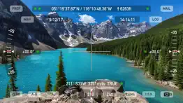
What is theodolite app? Theodolite is a multi-function viewfinder that combines a compass, two-axis inclinometer, rangefinder, GPS, map, nav calculator, and geo-overlay photo/movie camera into one indispensable app. Theodolite was one of the very first augmented reality (AR) apps when it was released in 2009, and it’s been downloaded and used by millions of customers since then. Uses are endless, and the app is great for land measurements, outdoor sports, sightseeing, navigation, and finding your way around. Theodolite is a pro grade app and is used extensively by surveyors, geologists, architects, engineers, competitive sportsmen, first responders, military personnel, and search and rescue workers around the world.
Theodolite lets you take data-overlay photos and movies with 2X-8X zoom. Overlay geographical data, angle markings, date/time, author/company info, and project notes directly on photos and movies for later reference. The same data is written into the metadata record of images, making image files self-contained data records. Third-party apps can tap into Theodolite's advanced camera functions with a camera sharing feature.
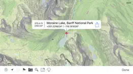
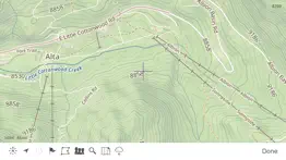
View current position on the built-in map with optional offline Outdoors maps that include topo contours, roads, trails, landmarks, campgrounds, ski lifts, and more. Live map markers continually update distance/heading relative to the current location and also show wayfinding info in the main viewfinder. Draw polygons on the map to mark things like property boundaries and trails, and import/export polygon data via KML.
Share map markers and nav calculator points with other users of Theodolite via text messages or e-mail. This powerful capability opens up a wide range of collaborative uses including team land surveying, accident investigations, spotting wild fires, triangulation of landmarks, and advanced tactical observation and targeting. With an optional in-app purchase to enable team tracking, you can share location with up to 20 people on Theodolite's map.
Theodolite includes features for serious users like a reference angle mode, nav calculator, map marker import/export, manual and automatic data logging with CSV and KML export, clipboard integration, %grade display, mil compass readout, optical rangefinders (including a mil-based reticle, sniper-style stadiametric graphs, and a variable 4X-24X scope), and night filters to improve use in dark conditions.
Theodolite can provide location in military grid reference system (MGRS) coordinates, Universal Transverse Mercator (UTM) coordinates, British/Irish National Grids, US National Grid, Maidenhead locator system, Map Grid of Australia, and six latitude/longitude formats. Optional US State Plane coordinates include SPCS27 and SPCS83 zones covering all US States. The optional Datum Pack adds over 230 geodetic datums to the app to improve position computation from GPS data, covering regions and countries on all continents around the world.
AR Layers include navigational aids like the sun, moon, planets, and Polaris (North star), and the optional US Mountain Summits layer that shows over 70,000 US mountain summits in the viewfinder.
Theodolite has been shown in Apple Keynotes, featured on the App Store, and has been a #1 selling Navigation app in App Stores around the world. Since its introduction in 2009, Theodolite has defined augmented reality navigation. The app continually introduces new technologies, pushing the limits of iOS app development and taking advantage of new hardware capabilities.
Find out why Apple named Theodolite one of the most amazing apps available and showed it being used to explore the Great Wall of China. Where will you take it on your next adventure?
Note: Theodolite is an iPhone app -- see “Theodolite HD” for use on an iPad. And be sure to check out the all-new "Theodolite for Watch" and put Theodolite on your wrist!
😍 Do you love Theodolite app? Please share your friends!

Please wait! Theodolite app comments loading...
Theodolite 9.1 Tips, Tricks, Cheats and Rules
What do you think of the Theodolite app? Can you share your complaints, experiences, or thoughts about the application with Craig Hunter and other users?

Theodolite 9.1 Apps Screenshots & Images
Theodolite iphone, ipad, apple watch and apple tv screenshot images, pictures.
| Language | English |
| Price | $8.99 |
| Adult Rating | 4+ years and older |
| Current Version | 9.1 |
| Play Store | com.hunter.theodolite |
| Compatibility | iOS 15.6 or later |
Theodolite (Versiyon 9.1) Install & Download
The application Theodolite was published in the category Navigation on 30 November 2009, Monday and was developed by Craig Hunter [Developer ID: 286743884]. This program file size is 29.61 MB. This app has been rated by 903 users and has a rating of 4.7 out of 5. Theodolite - Navigation app posted on 30 June 2025, Monday current version is 9.1 and works well on iOS 15.6 and higher versions. Google Play ID: com.hunter.theodolite. Languages supported by the app:
EN Download & Install Now!| App Name | Score | Comments | Price |
| Theodolite for Watch Reviews | 4.2 | 20 | $1.99 |
| Theodolite HD Reviews | 4.7 | 137 | $8.99 |
| Wx Reviews | 1 | No comment | $14.99 |
| Wx for iPad Reviews | 3.2 | 5 | $3.99 |
| Nav Camera Reviews | 4.0 | 34 | $3.99 |
New measure tool on map screen to compute distance and heading. Polygon popup label now includes perimeter length. Enlarged size of touch target for camera shutter button to include entire lower corner of screen for easier taps. Options to control specific geo-data elements included in photo/movie overlay. Revised rangefinder code for better fidelity on multi-lens camera systems. Fixed issue where certain characters in map marker titles would cause problems for KML export to Google Earth. Updated camera sharing feature that allows other apps to use Theodolite's camera for image & data capture. Minor bug fixes and tweaks.
| App Name | Released |
| Passio GO | 06 May 2017 |
| Electrify America | 03 June 2019 |
| KakaoMap - Korea No.1 Map | 27 February 2009 |
| Neshan Map | 04 May 2023 |
| EVgo - Fast EV Charging | 17 October 2017 |
Find on this site the customer service details of Theodolite. Besides contact details, the page also offers a brief overview of the digital toy company.
| App Name | Released |
| Light Pollution Map | 20 September 2020 |
| Illinois 511 Traffic Cameras | 03 April 2023 |
| Holding Pattern Trainer | 16 August 2011 |
| Blitzer.de PRO | 03 August 2022 |
| MilGPS | 01 December 2010 |
Discover how specific cryptocurrencies work — and get a bit of each crypto to try out for yourself. Coinbase is the easiest place to buy and sell cryptocurrency. Sign up and get started today.
| App Name | Released |
| Target | 24 November 2008 |
| BeReal. Your friends for real. | 08 January 2020 |
| Telegram Messenger | 14 August 2013 |
| Netflix | 01 April 2010 |
| Amazon Shopping | 03 December 2008 |
Install the Giftmio extension for smart shopping. Get notified about cashback opportunities, activate cashback in one click, and save money on purchases.
| App Name | Released |
| Shotgun King | 24 February 2026 |
| Shadowrocket | 13 April 2015 |
| Procreate Pocket | 17 December 2014 |
| PeakFinder | 12 March 2010 |
| Balatro | 26 September 2024 |
Each capsule is packed with pure, high-potency nootropic nutrients. No pointless additives. Just 100% natural brainpower. Third-party tested and validated by the Clean Label Project.
Adsterra is the most preferred ad network for those looking for an alternative to AdSense. Adsterra is the ideal choice for new sites with low daily traffic. In order to advertise on the site in Adsterra, like other ad networks, a certain traffic limit, domain age, etc. is required. There are no strict rules.
Keep personal info private, avoid scams, and protect yourself online with AI-powered technology.
Theodolite Comments & Reviews 2026
Nice app—Bundle isn’t complete. Visually beautiful. Clear on-screen layouts and useful outdoor navigational information in the theodolite and compass apps. Altimeter…meh, informative but not eye-catching but maybe that’s its point (?). Weather? Yeah, there are hundreds of apps that do that, so it’s not really the selling point of the app. However, I am very disappointed that (1) the bundle does not include the Apple Watch apps and the various datum sets and (2) even more puzzled/peeved that the purchase of the datum for one app in the bundle does not make those datum available for use with the other apps in the set. It doesn’t really seem like a “bundle” especially when there are other apps available from other vendors that do as much but without the “nickel and dime” price escalation every time you open the preferences. In short, I’m pleased with the compass (on the phone) but will likely not find use for the rest of the apps as they each require additional purchases for base map datum($3) and localized maps/state plane coordinates ($25).
Almost perfect...4.5/5. The uber-geek in me really loves this app. The only shortcoming is documentation. The latest update to the FAQ went a LONG way toward fixing this, but a little more is needed. For example, a screenshot of the app with each component named and explained a little would have been nice (like the different reticles). In all, I really like it...not far from a 5.0 Update...Theodolite finally gets a 5. This app has really matured. The latest updates, especially the in-app purchases with geo-referenced peak names, adds great functionality. If you are an app developer, look to Theodolite for inspiration on developing a full-featured app,. OUTSTANDING!
Great app!. I’ve had this app for quite a while and love it. It has a lot of information all brought together in a handy way. I use while hiking using it and my USGS 7.5 minute topo maps (or the Topo Map app). It uses the iPhone camera, so I often take a couple of pictures with it to help orient me when I’m traveling or taking photos in unfamiliar territory. It’s a survey and navigation tool and has a lot of data on each picture, not designed to replace your camera. I have not had any issues with it, and it’s GPS and compass correlate well with the GPS and compass on the iPhone and the Topo Maps app.
Excellent tool for navigation and documenting important places. This app is both fun and useful. If you ever need to show exactly where something is, or show that you did that job out in the back forty, this app will provide a photo which includes all the information you can possibly imagine- exact latitude and longitude, bearing, altitude, time, date, inclination in 3 dimensions. In principle someone else could very nearly stand in your exact footprints to see the scene, based on the photo. Another useful function is as a Sight Level. I put some bright tape on a tree or the side of the house at my eye level. Using this app I can move around and if I can see the tape I can tell within an inch or so my elevation relative to the tape. This helps with landscaping my yard, for example. So if you are a contractor, forester, or investigator, this would do a nice job for you. I use this app with Boy Scouts, not only for a handy compass bearing, but also for questions like, “If that tree were to fall, would it hit my tent?” (Hint: 45 degree vertical inclination). Or, “How side is that river?” (Classic map & compass exercise.) I cannot evaluate the accuracy of the measurements (apps are notorious for displaying way more accuracy than they really can achieve), but they seem good for my purposes. If you have a boat with good navcom, check the accuracy and let us know! I use it a lot and like it a great deal, and yes, it IS a great deal at this price!
Generally good app. Although I have had this app several years I have to say I am a neophyte. I've only used it to record locations and elevations in my engineering work. The elevations are only as good as the iPhone allows but it provides a good tool for rough relative measurements in the field. I have read the users guide and the program has some powerful features I hope to try some day.
MVB. Unique survey/camera tool that records lat/long, strike/dip, elevation/distance, time/date and many other geo-data parameters: useful to geologists, foresters, ecologists, cartographers, search & rescue, etc. Internal mapper included and/or can export data to Google Earth etc. If you are lost or injured and need rescue, as long as you’re near enough to a cell tower to pick up your transmission, you can send precise location data to rescuers. You can even send them a satellite photo of where you’re at!
In top 10 most used apps - love it. I set the text color to yellow so it would be readable with a bright cloudy sky. One snap with this data-rich app is super to support a field memo. I used this app to run a level line in about 60 foresights and backsights over an 1100 ft distance on a highway shoulder. A monopole is helpful for that use. Really use this one a lot.
Arizona Site Steward. I’ve been using this app for 6+ years and find it a valuable tool when out in the field. It saves me time from using my hand held gps then having to take a picture of the position. I have recommended this app to my colleagues for documenting archaeological subject matter. It’s well worth time to try it out.
The theodolite app. The theodolite app is a great tool for those that work and play in the great outdoors. If you are a game warden or in law enforcement this is a perfect work tool as well. I have used the theodolite app over the the last five years, for work and play. The app encodes all of the necessary info time LAT LONG and well as elevation and compass heading that the app was utilized at. This make it possible for another party to stand in the same location and recreate the same observation made. Theodolite will shoot still photos as well as video with encoded the info into the photograph.
Great field tool. I use his tool in the context of field work for crisis resilience and also farm planning. From antenna angles in Haiti to field documentation on a farm, this app is my go-to to capture situational awareness metadata. The interface is simple and yet rich in options, and makes an easy chore of capturing or establishing headings, angles, etc. I use it as is or plugging in my Bad Elf external GPS for added precision and helping the iphone battery life. Heck I've even used it to level picture frames but it's not as exciting. Only thing I'd love to see added to the main screen is the HDOP and VDOP - the GPS precision. Very different to capture data with 2m error than 30m.
Fun for the map-minded casual explorer. Really enjoying the app. Uses for me include designing multi-stage geocaches where I need bearing and distance between points for the stages. Also was walking on the beach and was curious how far away a cell tower was, and the A-B feature made it easy to triangulate and see the estimated position on the map. The controls feel really responsive (for example the zoom in/out) and the UI is clear and easy to use. Love the translucent pillar that appears in the viewfinder to show you the location of the current active map point, and how it changes to a planted flag when you get closer. Also super easy to share out coords by copying the text-based log or by generating an email with coords and tagged photo. AR planet layer is neat, and I like how putting crosshairs on a planet causes a name label to appear.
Invaluable Tool. As a major electric utility serving over 15 million residential customers, we have been using Theodolite for several years when setting up helicopter lifts maintaining our infrastructure. Theodolite has proven to be extremely useful in measuring, imaging, geo-tagging and documenting our site plans all at once. This saves hours in the field and returns that time to lift plan development. In turn, that enables much greater productivity that enhances the return on investment for a dedicated aircraft fleet.
Perfect for Construction Tracking. I am an ITS and Tolling assessor representing the Colorado Department of Transportation and I use this app daily for tracking project progress. I am constantly taking photos of different job sites and don’t always have time to add them into PlanGrid that second. I used to have problems remembering where the photos were taken or even what they were taken for so to have the information imbedded into the photos is very helpful and very useful. Many of the other construction managers I work with now use Theodolite daily to track progress also. Thanks Theodolite!
Absolutely the BEST!. The ability to have all this precise spatial and positional information overlaid on the cameras on my iPad Mini or iPhone is awesome. I use it to lay out foundations, navigate the old fashioned way with gps off, calculate distances using landmarks of known height, or the reverse, just for kicks. I have reviewed maybe half a dozen apps out of several hundred I have purchased. This one was certainly worth the time to heap praises upon it! Awesome app! Well done!
Perfect for my uses. I have no real use for this app it’s just a toy for me. That being said I initially got the app for the emergency situation where having a range finder and compass would be useful. So far I’ve not needed it for that purpose but if I should need it for such an occasion I feel my bases would be covered with the tools provided within.
Theodolite. This is my favorite app. I most recently used it to find a Forest fire that had gotten within 3.1 miles of us. I took photographs at various places in the burnt area and then plotted the location on a Quadrangle map. But my main use is to record the location of petroglyphs in remote ( and not so remote sites) in the far west of the U.S. And Canada. Of course in some places satellite connection cannot be made but most of the time it can be. Not only do I get the time and the longitude and latitude and elevation, but also the azimuth. This latter is important because by adding 180 degrees to the reading I can tell what direction the petroglyph is facing. By placing a measuring graphic near the subject the theodolite photo also displays the size of the petroglyph. The theodolite record is redundant because I usually take more photographs with a camera, which includes the time and sometimes the coordinates, but never the azimuth or elevation. This along with iPhone Notebook allows me to travel lighter and scramble in the rocks more safely.
Great app. This is a great app. I’m sure it does lots more than I can figure out, but for what I wanted it for its great. The very best part is the customer service!! I’m not very tech savvy, but Craig walked my through everything I needed. Even after multiple requests on my part he was always there with a quick reply even on sundays. Get this app. You’ll like it
Theodolite camera. Fantastic for all sorts of activities. Especially as image based way point log. Recently use it to capture the damage done by direct hit from a lightning strike on my house. The image proved without doubt when, where and what had the damage bad been done. And save your like on extreme backpacking adventures.
Well designed multi functional app. Works well as a clinometer and useful for recording information on a photo relating to a specific place. I use it to map things like small infestations of invasive weeds on my ranch so I can come back later and deal with them. I don't need all of the capabilities and have tried several simpler apps, but keep coming back to Theodolite because it works better.
Great for work. I’m a geologist and I use this app for work. I switched from Solocator because the image overlays look less cluttered and more professional with Theodolite. Solocator has similar features but altogether this app functions better (Solocator is goofy with phone rotation too). The only thing that would make Theodolite even better would be if there was more control over which data are included in the overlay. For example, I might want to exclude altitude, elevation angle, horizon angle and zoom but retain azimuth, Lat/Lon and date/time in some cases.
Amazing App for doing RF/Wireless Systems Engineering. I have been using this app since it came out and it's probably the best app I have on my iPhone to assist with RF Engineering. It allows you to document site locations and then export to a .KMZ file which is incredibly effective way to do surveys and map out locations . It also allows you to get approximate azimuth and horizontal alignment information so that when it's time to install the equipment you will have that information ready to go. I have never had any problems with it and it's with EVERY PENNY.
Great App. Ooutstanding App well worth the money. You ‘ll need time to let it all sink. Getting it set up properly is the biggest challenge, but once set tracks your every step. It will provide more data than you might want but set it up for your personal needs. A little daunting at first in as much it’s capabilities are many. But you can use the tracker straight away . 5+ Stars
Great tool for Deer Hunters!. Perfectly photograph, locate (GPS), and geographically ID, rubs and scrapes as well as other signs. Plot direction coming from and heading to in order to locate yourself between bedding and feeding grounds. This tool used with another available app allows you to completely survey, photo and catalog your favorite hunting spots and even have the measured land mass square footage calculated to help figure out the sizes of herds that area could support.
A beginner's view. Theodolite does a lot of stuff, more than I've had time to learn about so far. Currently I use it to photograph invasive plants, and can email the photo with coordinates to someone else, or to my own machine at work. One hitch--it worked for a while, but then I stopped receiving the emails. Turns out they were hung up in the iPhone mail outbox. Just select and resend. I look forward to learning about the other features as I get a chance. I haven't checked the coordinates against a handheld GPS yet, but it is accurate enough for my use.
Best app for being in the woods. I use this app for hiking, scouting and hunting. It keeps me from getting lost ... a lot :) It would be nice if one could geotag pictures to saved waypoints. Maybe one can and I just don’t know it’s available. A cool option would be access to older satellite pictures to see in the Fall/ winter , which trees are hardwoods and which are pines. That would aid hunters, hikers , wildlife photographers, bird watchers.
Camera Doesn't Focus Well. I love this app and all. I am a surveyor and it's great for showing where and what way you are taking the photo. Especially with the datums and SPCS. BUT, the camera needs to be worked on a bit. It needs to focus for light. I wanted to use this for when I was locating manholes. Would have worked great, but the photo wouldn't adjust for the darkness of the hole. Yes, even with the flash. Please fix this. You will then receive my 5 star.
No updates. I agree I gave had no bugs to report. But how about innovation? Can you say that you shouldn’t provide new or expanded capability. When people pay for a licensed software they support development of innovation. Just to keep up with hardware and firmware updates and bug fixes is not being innovative. This must be the first perfect application that doesn't need updates to keep current with the iOS. No updates since 2015. One stars because I like the app but it needs to stay current with hardware and OS changes.
A fabulous little theodolite app. Provides most of the functions that a $3k theodolite would provide, for a little bit cheaper than $3k. If you care about angles, levels and locations, you’ll love this app. The 2,4x zoom feature makes it particularly easy to align precisely with small targets. The GPS lat-longs are embedded in the logs for convenient review. It’s great!
Most Useful. I like everything, had an older version on my iPhone 6 that would not work on my newer iPhone X. Just downloaded this, loving it. ONE BIG PROBLEM, I cannot close this app, I’ve tried everything and I can’t close it! ***** Resolved !! If I am holding the phone horizontally then I can slide/close this app but it won’t close in a vertical phone position.
Still pleased. Was really great, however the developer stopped updating Update:I apologize if I was hasty. Perhaps my issue is on my end. I have enjoyed this app for a long time, and always felt it was well worth the price. I especially appreciate that it works in remote areas. I always need it when I am far from service. I will see if I can address my issues from my platform. I should have done my homework beforehand.
Best waypoint mapping app. Worth every penny. Easy to use, just takes a few minutes playing with it to figure out the basics. Theodolite Gives me way more info then I know what to do with. I am using it to do a tree survey on my land to figure out where I want to build. Easy 2 clicks to view all my data on google earth. Can't wait use it on a trip.
Powerful, Amazing and Great Value. I use Theodolite once in a while but every time I open the app, even if it's just to show my kids something neat that only this app could render, I'm reminded about how good app developers and the iOS platform can combine to create what just a few years ago would have been only a fantasy. Great work! I love Theodolite.
An Outstanding App. Accurate. Best App For The Job.. Very sensitive. Better accuracy if placed on a fixed platform or stand. Fine detail measurements. The slightest movement is measured. On each of the scales, compass for example, the reading doesn’t bounce between each degree. Movement slides smoothly between the degrees and angles. I’ve never used a surveyor’s theodolite. But, I think this app gives you enough features to roughly measure your property. There are additional features you can get that provide even more professional land features. Get this free application. Rate it! Rate it! Rate it! Simply put, I love this app and I’m sure you will appreciate it too.
A tool for avalanche forecasters and backcountry skiers/boarders.. Theodolite is a fantastic tool for avalanche professionals and all backcountry skiers and riders. For the professionals, take a photo of your pit to obtain and record location, altitude, aspect, date and time. Take a side view, tilting to the slope and you have the angle. This shortens the time required to obtain and record data, while increasing accuracy. For backcountry recreational users, use theodolite to determine aspect (some easy math required) and altitude. A side view shot and you have slope angle. Are you on plan for angle, aspect and elevation?
Fascinating application. Theodolite Pro is a fascinating application showcasing some of the abilities the iPhone is capable of. Whether playing around and curiously experimenting, or seriously putting your iPhone to work, it's surprising to find quite a few uses limited only by one's imagination. So far the application has worked flawlessly and been extremely accurate. Great job!! This app would be a great gift to a student learning geometry, or an outdoors person with a curious nature, or just someone who likes to experiment. I've seen lots of articles and apps about compasses , levels, protractors , and similar devices. None that I have read about or used can match Theodolite. Additionally, Theodolite is a well thought out app with a great user manual. I haven't had an issue or crash using Theodolite on a 3GS, 4S, and 6 Plus on their various IOS versions. This is one app that will stay on my device.
Great ap for construction and mapping. This is a great app, let me share an example; a small city i was employed at had just resurfaced most of the asphalt roads. I got a call from the boss about some truck leaking hydraulic fluid on our newly surfaced roadways. If you dont know hydraulic fluid is like a solvent for asphalt and creates holes and ultimately will lead to a failure in the road surface if the fluid leaks enough. It was not long before i picked up the trail of the culprit, a local garbage truck , caught up to the driver of the leaky truck and informed him he was leaking hydraulic fluid and made him turn off his hydraulic unit and go back to his shop and to inform his boss of the occurrence. It wasn’t long before his boss contacted me and argued with me about the extent of the damages. I provided a map of the trucks route and pictures with times, gps locations. Argument over, but the boss wanted to know how i recorded this stuff. Showed him the ap and i think ,he’s a customer too. I know all the guys on my engineering staff purchased this ap and use it to record all kinds of data, great ap
More than an app, its a pro tool. I have relied on this app when I require a precision tool for outdoor photography. Its got everything and more. I use this when Im hiking alone to record and send location updates to friends and family. They can enjoy the pictures and open the location in google earth and others to see EXACTLY when and where it was taken. Awesome for hike review as well. Well done Team!
Incompatible with Wireless Remotes. I like using Theodolite to document where I find geocaches. There are also instances when I’d like to take a photo from a tripod. The issue I have is that it does not trigger via Bluetooth remotes. When I try to use the shutter release on the remote, it tries to adjust the volume on the phone instead. When one considers the utility of precise position data available for Theodolite, using a remote trigger would be an added bonus. Thanks for a great product.
Great app used it for years.. This app will give you a lot of info on the lay of the land. The only caveat I have is the camera button placement. I would like to use my right hand index finger at the upper right hand corner with a decent size button and right underneath it the zoom button. At the moment I have to search for it which in turn disrupts the photo.
Theodolite. While l can’t claim to have a good reason to use this app, I can imagine situations where it could be very valuable. Nevertheless I really love it and find reasons to play with it a lot. It is particularly fun when back packing or traveling. It tells me where I am and where I’m looking with absolute precision—every time. Everyone who enjoys technology gadgets that always work as expected, this is the app.
Just what I was looking for. I’ve been searching for an app to help me plan photographing the solar eclipse on 10 June 2021. I need an app that will tell me accurate and precisely what the azimuth of various features so I can determine exactly where the Sun will rise. This app does that. The key to the accuracy is that this app allows you to manually calibrate the app to a known azimuth, such as the sun. And your can turn off the accelerometer and rely upon just the more accurate gyroscope for maintaining accuracy over a short period of time. The display of the app is remarkable. I am extremely impressed by the work the developer has put into this app and his other apps.
Versatile and functional. I use Theodolite for Search and Rescue. It makes transmitting geo locations very easy. The information I need is all readily available, allowing me to transmit in multiple formats as well. With cell tower connection one photo being sent takes out any possibility for error. I can also use it to get an estimate of slope for potential avalanche danger. Very well made app.
Review. Indispensable. Been using it for years, time to review it. We do storm water and erosion control and always always have it at hand, always showing it to people, best thing for site assessments, continually saves us from having to go back and measure something. Would you consider an option in Prefs to make the angle readouts announce when they are at zero? Especially the left/right tilt. Hard to see them in New Mexico sunlight sometimes. Or maybe an option to make it bigger when you need to. Thanks for the great app.
Feature suggestion. Love this app. I use it exclusively for work in land surveying. I would love to see a feature that auto sorts pictures from the app into a designated folder in my phone. I am using it with an iPhone and the trouble is that google photos backs up all of my work photos along with personal ones. I can’t seem to find a way to keep them separate
A great tool for documentation. Back when I worked disaster recovery for the State, I used this extensively to document damaged infrastructure (roads, bridges, water treatment plants, etc) damaged by natural disasters. We could document the exact location of damage and take after-photos to show the damage had been repaired.
Shows the best of a smartphone. I have had this app for many years. I write very few reviews and this is one of the few I felt compelled to comment upon. This is probably one of the best and most powerful apps I have seen and shows the best of what a smartphone can do. Many, most may not need or appreciate something like this but I find it remarkable what can be done with a phone in our pocket. If you are reading reviews on this app though, you are probably in the other category. If you know anything about maps, orienteering, surveying, flying or navigating this is remarkable. Get it. I buy almost no apps but this one I did and still think it is so worth it. To the devs, sincerely thank you. Be very cool if USGS maps could be downloaded and used as some kind of offline overlay or AR, IDK but a thought that occurred to me….
Problem with IPhone Compass. I think the Theodolite app is very well designed. However, it relies on the compass in the iPhone 7 plus to be accurate. That's a big problem! All iPhone 7 plus phones have a worthless compass in them... I can't use the Theodolite app for anything real because all of the data that would need an accurate compass heading is wrong by incredible amounts. If you Google the compass issue on iPhone 7, you'll see everyone has pretty much the same issue and only Apple can fix it but they don't have much interest! So... Theodolite is good, maybe on other phones other than 7's... not useful on a 7 plus.
This Will Change Your Outdoor Life Forever. This is the most awesome app ever conceived for outdoorsmen, hikers, bikers, hunters, relic & meteorite hunters, golfers and anyone who needs information about exact location (GPS), altitude/elevation, incline/dip & instant feedback plus (you get to add notes to your photos). I marvel at its features each time I use it. Kudos to its creators! It has more applications than I could ever use and I use a lot. Take the time to learn & it will change your outdoor life forever.
Surveying my world. I’m not a professional in any field where this is in constant use, but it has always been the right tool to use in special situations. Whether hiking and wanting a numerically geographic record of the landscape or conducting walking tours in the city and wondering about whether a particular building had a tilt, I always relied on my trusty app to provide the data. With so much information in the screen, it provides a factual and entertaining record that is useful for a long time.
Good app needs more features. I use this app for the Telecommunications field because of the time stamp it includes in the pictures. I like the app but I do have a couple of suggestions. 1. We should be able to perform a reverse azimuth with the app. 2. We should be able to access both cameras. Sometimes pictures are taken in tight places and it requires me to look at the screen to ensure its in focus. 3. We should be able to move the timestamp in the picture itself, or when taking the picture it should move automatically when holding the phone vertically. 4. We should be able to use the existing buttons on the phone to take pictures. Sometimes Im over 200ft on a tower and it is often difficult to hold and take a picture with one hand while fearing dropping my phone. I believe these additions would be very beneficial. I do like the App and I do find it very useful.
Did you know that you can earn 25 USD from our site just by registering? Get $25 for free by joining Payoneer!
superb. One of the best apps, it’s a joy to use.
Data logging not working. When I log data, copy, then mail it I get the picture and point that the app saw when I hit the copy button. Disappointing
Great Idea. A great concept button a bit fiddly but you can only use what you have
Not bad. Being able to change the size of the text would be useful otherwise a great app
Altitude not accurate. If could try it before buy I wouldnt have had. Waste of money. Altitude doesnt include decimals and is not sensitive (made a trial with 2 meters difference and didnt move)
App review. An absolutely bang on app, excellent performance and well worth the small amount to pay, carry on the great work
Theodolite Pro. Brilliant app which is extremely useful and is not a toy, very professional and never fails to impress. Use it often for site survey for radio communications and propagation modeling. Well done.
Recommended. Very powerful and useful tool
Great app. This is a great app. I’ve used it a number of times for jobs I’ve done. I’m no engineer, nor experienced in operating a theodolite but trial & error worked at first & then speaking with engineers helped. I still use the app for obstacles on or near aerodromes. It’s a ‘tick’ from me.
Very Powerful. Easily the best app on the market for anyone that needs to do fieldwork or onsite inspections for their work. Mapping resolution is excellent and bearings function very useful. Time stamping of images also helps get the full picture following an inspection.
Great app.. Excellent app. The screen shots look great in my Bushfire Threat Assessment reports. The pics have all the geographical info that I need. Elevations are sometimes questionable but overall very satisfied.
Really powerful. I only use a fraction of the capability. A great integration of the phone capability, maths and domain knowledge.
Theodolite Review. Good app for construction photos. Would prefer if it was in SI format though.
Great app. Brilliant for fire service application
Great App. Great app, easy to use!
The closest you’ll get to Luke’s view of Hoth. A little hard to figure out some of the functions, but they’re so useful when you’re curious about where smoke is coming from, how high that tower is, etc.
An excellent tool. Provided of course that you make sure your phone compass is working correctly, with no steel nearby!. I made a crude support for my iPhone, and a laser distance measure to mount on the head of a Manfrotto tripod; a kind of very crude “total station” for a home driveway survey and drawings, but I neglected magnetic attraction between the phone and the laser, and the screws in my contraption. As a result all my bearings were useless! Not Theodolites fault of course! An excellent tool
Excellent. Highly recommended.
Latitude with photo. A great ap to put latitude, elevation and longitude on a photo
Can’t load theodolite for watch. I have paid for this app ( twice), but it does not appear either on phone or on watch, but in App Store it confirms that it has been purchased. I can’t even delete it and try to start again because it just does not appear anywhere. Can someone help?
Not that user friendly. Maybe I just can’t work it out, but removing all info off the screen i.e. crosshairs, angle etc isn’t obvious. I went into camera settings and turned crosshairs etc to off and they still remain on the screen and in the photo.
Why do the cross hairs move?!?!. This is driving me insane - I take snapshots with this app, lining up the object in the crosshairs, but when I look back at these snapshots in the album, the crosshairs are nowhere near the object? Not at all centred on what was on screen.
Theodolite. Theodolite is a great tool. It is very well set out and very useful. Excellent !
Theodolite. Great , easy to use , supplies more than enough info on the photos than I need .
This is really great app. Produces very good results. Great work!!
Review. Excellent product and value. Great for annotating photos with angle and slope information.
Great app. This does exactly what I need it to do.
Surprisingly useful. Try it out!
Works well. Have used this app a number of times in my mineral exploration and works as it should No complaints
Whew. Took me a while to wrap my head around the usefulness of this app but now I use it every couple of days. 👍
Theodo delight. I am an engineer of some senior years and I use this app every time I go to site. The records are accurate enough to use for reports designs and court documents. Muck lighter to carry than a total station.
Few bugs and design issues. I'm in the IT industry, and a colleague introduced me to Theodolite. I find it useful and it serves my needs well. However, I encountered a few bugs and design issues during my first use: 1) I am unable to close the app directly. The only workaround I found is to swipe up to access the notification center and then open another app. From there, I can close both apps by swiping up, which feels inconvenient. 2) I took several photos in both landscape and portrait modes, but all of them are saved in portrait orientation in my Photos library, which is frustrating. 3) I added notes to my pictures, which worked well. However, the position of the "take photo" button and the backspace key on the pop-up keyboard are too close to each other. This caused me to accidentally delete parts of my notes multiple times, which was time-consuming and frustrating. Overall, the app is helpful, but addressing these issues would significantly improve the user experience.
Very Cool. Absolutely brilliant
Great terrain scoping companion. Plenty of things to say. The ability to capture an image with all the overlays if positional info is the icing on the cake.
Spurious orientation measurements. I’m a relatively new user and I was working through validating and verifying the dip and azimuth data displayed. I used Apple’s Compass app and Field Move to check my measurements. I found that Theodolite was producing spurious values. What’s more, while checking these values I found that the other programs would start to produce spurious values after I initiated Theodolite and switched between them. I restarted the phone and Compass and Field Move were reliably showing correct readings. But as soon as Theodolite starts, the values become spurious. Additionally, when I lay my phone down, the tilt values jump around all over the place. The look and feel of the app is excellent, please address this critical issue and I would be more than happy to increase my rating! At the moment, it is unusable.
Very useful app. The things you can do with it are fantastic.
Great app. I use this app for photographing mushrooms. Great for anyone who needs location to be stored with the image.
Complete and Accurate Information. One of the best/handy Apps for Astrophotographers/Photographers! Very Accurate! I use it to plan my Astrophotography. I use it to check location suitability for imaging ahead of time and it has never let me down! I would highly recommend it :) LRSM99
HR Max. The best App works very well in grader, dozers, loaders, and on foot 10/10 Thank You 😎
Great app. An excellent app. Works fantastic. Auto correction for magnetic to true north is a good useful feature.
Excellent tool. I use theodolite all the time on bush walks to record specific locations, check bearings and take general measurements. It's worth every cent. One of the highest quality and most useful tools for utilising the iphone's many physical interpretive devices.
Great I use Theodolite on my steep farm for planning. I use Theodolite on my steep farm for planning roads and now building.
Review. Great App, awesome to take a photo and email with all location and directional info included.
Great work tool. I use it for work on our fire management team
Reliable App. This is an easy to use reliable app
Keeping stored notes. I love your app But I would like store a number of sites, which I could reuse, without loosing on add notes , can this be achieved Cheers Wayne
love this app. use this app often to record location of places of interest in the outdoors
Professional features and potential. Working with daily site surveys this tool with all its features is as invaluable as it is simple to use. Brilliant. Should be part of every tool kit.
Excellent app. I have used Theodolite for work on several occasions. Each time, engineers are blown away with the info captured in photos - especially when dealing with identical equipment.... In my other life as a volunteer firefighter, Theodolite is useful as a mobile fire-spotting tower.
Great. Almost perfect. It does everything it says it does very well. If only I had the option to create a 1 second interval track file within the app then I wouldn't have to keep swapping between Theodolite and a simple track logger when I was in the field collecting data.
Imagine you at your best. All the time. Picture yourself at your sharpest and most productive. Your most alert and focused. Your most lucid, creative and confident. At work. At play. In every area of your life. Add Mind Lab Pro® v4.0 to your daily routine and uncap your true potential. Buy Now!
Great with a few small flaws but it could be the phone. I love this app. Is great for construction work and works great without cell service. One thing I noticed is if I am inside a vehicle sometimes the compass is off, I read this can be the case and I’m not sure if there’s a way to fix it in the app or if this is more an issue with the phone itself. The other thing I noticed is sometimes the screen will load with all the technical information but the view finder will just be completely black. I have to close and restart it a few times before it works again. I’ve also had this same issue with my phones regular camera so I’m not sure if it’s App related or phone related. Happens more often than not in the app though. If these end up being just problems with the phone itself I would 100% give this a 5 star rating. But otherwise it is a very useful app, especially when time stamps and GPS locations are a must! It is also by far the cleanest Geotagging photo app I’ve seen. All the information is up in the corner and doesn’t take away from the main focus of the photo.
Best photo app for work. This is an excellent app for the professional in the field taking photos of a project or work site as it progresses. Thank you!
Disappointed. Lacking Options for the Price. Not sure why the app name needs to be included in the file name when using the Prefix and Date option.
Great app. Great app but the UTM coordinations are backwards.
Enjoying Theodolite for many years. App performs well, impresses many and essential to recording specifics about business related locations
The Best app. Fantastic app. The most accurate I have use. All features in one app
Great. Love this app Straightforward to use Great for fieldwork I use it every time I’m out works well and is reliable Saves carrying compass, gps, and camera in the field
Very Handy. A very good and handy app. A bit more info about using the rangefinder, especially in military mode would be helpful for new users
Excellent App. Super great app for a variety of uses. 10 stars.
UTM Coordinates. I shoot one of the control monument just to test the coordinates shown on the image and I got less than a couple meters from the published coordinates. My data was enable while using for this app.
Super diggems. Amazing app
As advertised. The developers have provided a stable application. Simply, it works as advertised. I awarded only 4 stars to allow room for improvement.
The program. Nice program
*****. Been using it for years. Excellent app!
Fantastic app. As a Fire Chief, I use this app regularly to document scenes for investigative and evidentiary purposes. Have recommended this app to many other colleagues. Wouldn’t be without it.
Problem has been resolved .. Now my camera won’t allow pictures to be sent to the phone. iOS has not been changed on my I Phone. Great up date!!!!
Very useful on the worksite!. I work in land surveying and the drafters in my office love the annotations overlaid on the photos I take!
Theodolite. Great tool, I use it for personally and professionally. I have recommended this product to many people.
Great!. Great app, I use it almost daily. Geo-tags photos professionally. Makes for good looking additions to your report (clients will be impressed).
Theodolite. Great app. Far superior to other apps
Cannot turn Theodolite camera off. I currently bought the iPhone X’s Max and just happened to download the Theodolite camera app but for some reason I cannot exit the camera feature off the main screen. I have to turn the entire phone off and restart my iPhone Xs max to get back on my homepage. Currently the app does not allow you to swipe the camera function off the main page. This is definitely a bug that needs to be fixed as I cannot use this app until then.
tec_64. Nice!
Clint real nice guy Oilfeild consulting. I think it’s a brilliant tool it would be a nice option to see legal subdivision from the DLS program in Canada it’s the system we use in the oil field in Saskatchewan Alberta and a part of British Columbia
Brilliant!. Amazing what you can get for $4 nowadays - I only regret I haven't had this for the past 40 years. I have the "Pro" version and it works SO WELL! Stand in the middle of a site, shoot a wonderfully informative picture, and e-mail it right on the spot. I couldn't be more impressed - I'd have bought a 'smart phone' for this app alone.
David Alsop. I use this app all the time for surveying and satellite locating and even for hiking. Thanks to the developers
Theodolite. An amazing app. Wish it had been available when I was serving. Lots of great info in the display
Theodolite. Good tool. Rumpelstiltskin
Great app. Great app that provides the critical information that I need.
Theodolite. I have been using this app to record and report serious road hazards for many years now. All the information you could need recorded plus proof in the picture. Very helpful quick and impossible to repute.
Great features but. But why does it switch my music output to iPhone (away from airplay...) when I use it !
great tool, but.... it has a major flaw- there is no option to download offline maps. With the capacity of modern smartphones, one can download the whole countries. WiFi or cell data are not readily available in the wilderness and this along significantly cuts the use of this app.
Outstanding. This is my favourite app. Works as advertised and provides value.
A really great navigation app.. There are no real flaws I can think of. It's a great app and I look forward to seeing what updates bring.
Great app for work! Still pauses audio though. I use this daily in the field and it works great as a time stamp and gps reference for when/where I was. Only complaint is that I’ve had this app for over 3 years and it still pauses audio when in use. I understand if I have it in video record mode, but for plain pictures I don’t understand why it overrides whatever audio I have on. If it’s just pausing my music that’s just an annoyance (sometimes taking photos every 10 min or so for a 12 hour day so it really sucks), but if I have a teams meeting or phone call I basically can’t use the app at the same time.
Feature request.. I recently got a simple phone mount for my tripod. It came with a Bluetooth shutter remote. If you make it so the app can add data to log on volume up press, or even just a picture then the shutter remote would be an exceptional tool along side theodolite. Or an option to pick either in the settings. This will eliminate shake or any slight movement when you’re logging a coordinate.
Not Universal. Had to re-purchase from iPad to iPhone. Not nice at this price but needed it for both.
nice Spartan interface. Very useful program. Been using it for some time now, and it appears quite stable.
Great!. Great app. Work well and is really usefull in my job.
Amateur Survey Gold. This app allowed me to find corners and plot property lines in thick uncharted bush. And helped me find my way out again. Have also used it to mark drainage channels and contour lines. It’s smarter than I am and truly useful.
Great app. Must have if you work in construction.. This app is great for layout of taking pictures of angles for reference. Well worth it.
Excellent. Very accurate. The map feature is really cool. You can set it to turn in your direction. Unlike the Maps feature on iPhone where you have to constantly reset it so that it changes the map in the direction you’re moving. I got this app early in its development, and it’s always worked flawlessly. I would recommend it.
Great app even after years of use. I’ve been using this app since 2017. It is reliable, rarely crashes, and very useful. I only use it for photo markups and don’t use the A-B distance estimate or other functions. I occasionally find that rotating the camera orientation creates a glitch where the screen goes blank and the app needs to be closed to regain functionality. Please update to change options for stamped info: I want to customize each line of the stamped information but can’t seem to turn each piece on or off. I only want Date-time, UTM position, and my photo note. Is this possible? I’m looking for an alternative app currently that is more streamlined for these markups but I would love to keep using theodolite.
Wow!. This is a great app. I use it for work almost every day. Bravo!
Great quality. App is perfect for environmental surveys and geo referencing photos
Excellent. I forgot I had this app. While thinning out my vast library of apps, I came across this gem again. Re-loaded it right away. It is a great app, showing exactly where you are, emailing anyone direct from the app. Full size photo or screen shots are great. Even take videos with all the data displayed. I'm glad it hasn't been left behind like so many other apps!
Boss. Excellent app, if I could learn all its features.
Great app. Just need to figure out how to use it!
Essential for work. This is a great tool to record progress on a project, the embedded information means you will never need to wonder ‘where & when’ was that. Quick and easy to enter notes about the photo. Love it!
Most Useful App. This app replaces a compass and inclinometer for me. It means that when I go to a site, I only need to bring my iPhone, charged. In the past, I'd need a phone, camera, compass,pen, paper and inclinometer. Having a photographic record of slope angles is streets ahead.
Incredibly useful for trail builders. We use the app for determining slope of the land where we want to build new hiking and biking trails. It’s perfect for this! Highly recommended.
Adsterra is the most preferred ad network for those looking for an alternative to AdSense. Adsterra is the ideal choice for new sites with low daily traffic. In order to advertise on the site in Adsterra, like other ad networks, a certain traffic limit, domain age, etc. is required. There are no strict rules. Sign up!
AKMike. I love the app for work as it geotags on the photos BUT just put it on my XR and the app will mot let you close out of it Cant swipe up to close it off the screen Not sure if anyone else has this issue If its the app please fix it as i used it almost daily over the past 4-5 yrs
Theodolite is a great tool. Always use this app any time you need to document a utility strike or accident on your project . This allows instant email to loss prevention Dept with GPS locations and several other features that will pin point area . Well worth the price !
Very Impressive. This is a fantastic app for Land Surveyors. It can replace your Suunto compass & clinometer. It is extremely refined & powerful, is great for logging reference ties, & even has State Plane now, available as an extra purchase. I even contacted the developer with a recommended improvement, and it was incorporated into the update. Too much to mention.
Best App Ive ever used. This app works great for me in my work. I highly recommend it. Has never had any flaws or bugs. It is extremely valuable to me. I have recommended to many others in my line of work and they all love it too. K
Great App. The Theodolite App is great! I use this app as one of my tools while working sometimes and it has helped me to be able to explain situations and the correct attitude and altitude of the photos. You can not go wrong by acquiring this app!
An explorers tool. I use this to document unique locations I visit, or when doing a field analysis. Great for record keeping. As the app evolves it is a great example of the iPhone as a data recording location interface. I have a photo taken in Ecuador at 10,000 feet above sea level, lattitude zero, date 01. Awesome
#1 Work Tool. An absolutely essential tool for my work. Time savings, accurate locations, date time stamps and the ability to make on the spot notations without having to do so in two paces... The one real reason I keep using iPhones/Pads.
Now you know where you were. Ever take a picture and not remember exactly where you were? This app solves that problem. Excellent for travel tours, sciences, hiking. Best of all you can document a trama event for legal purposes. It is also the general photo app on my phone.
Awesome travel/hunt/site seeing app. Total info on location, attitude & altitude. Snap a pic of unknown peak, junction, or hunt/fish location and info is stored on pic, even compass angle when taking pic. I don't fly. But an accurate landscape mount would make this a serious nav tool.
Fantastic. I use this app to help document location of evidence or clues when doing my job. Great to basically have a photo with a location overlay over the photo giving all the pertinent info. Thanks for a great app!
Essential. This app is essential for providing an array of info that is critical to fully document a location of interest and what can be found there. I have used it to document locations that have been visited for field trips, guides, evidence, and many other applications. For me, as a geologist, scientist, teacher, guide, and explorer.
Essential App for Location Scouting. Being a night sky photographer, I use Theodolite for scouting locations to photograph the Milky Way. Oftentimes I need to know the elevation of a feature as well as compass points. This app is essential. I love the capture screenshot feature. In one photo I have all pertinent data I need for future reference. Awesome tool!
Excellent. These Hunter Research apps are quite useful, easy to use and offer terrific utility for anyone who works or plays outdoors. In-app purchases add utility and are well worth the modest expense. (This comment revised to excise remarks about in-app purchases not transferring across devices. See developer statement nearby.)
Theodolite makes my job easier.... Great app, allows me to geotag objects & places easily for documentation and/or sharing. Easy to set up and modify as need changes. Facilitates field measurements. Have given copies to several friends & colleagues...
Land Management Tool. We live on 30 timbered acres in the Matanuska Valley. I have yet to understand and integrate all the features of this app. in my head. Once I have done so it will allow me to understand more fully the resources I have available and sustainably manage them.
Theodolite. Excellent app! I use this for inventorying and mapping trees for Master Naturalist projects. It is a wonderful one-stop app to record the data and locate GPS coordinates on a map. I am so impressed with the detail that went into producing and maintaining the app. It really works. I’d be lost without it.
Use it weekly. It's a very useful camera tool for me as a surveyor doing recon work. I need to know that information can't be separated from the image, or that it's still useful to people with less sophisticated equipment in the field.
IOS Automation Support. Please update to support IOS shortcut automation so I can make it a triggered “default” app when the camera is opened. Would be great if it would work with Metrotech VMMAP so I can attach stamped photos to synced points from my locator and export as .kml all together. Otherwise great app. I use it all the time for line locating/onecalls.
Great app. I downloaded this app several years ago. I have used it to check elevations around my house, elevations while hiking Mt Elbert or various other Apps. Even used it at a rural museum to find actual location of the old town (buried in a lake) in comparison to my own property. Lots of applications
Future update. Great app I use these app every day since I work in solar I would just like to be able to snap pictures using one of the Camara buttons . The small button on the screen is kind of difficult especially since my fingers are alittle bigger . Maybe that can be in one of the updates
Helpful. This has been helpful to us when laying out buildings in our area. I am in the Shenandoah Valley and a lot of what we build is on the side of a hill. Very good tool for getting an idea how things lay before we get to the detail site plan. Also used this for clearing tree tops for satellite dishes.
Combines photo, surveying and GPS. Great app with both practical and entertainment value. Updates make this app even better with triple camera and distance features!!
This App Keeps Getting Better and Better. I've had this app since its release and its features keep getting better and better. There's nothing else like it on the market, and it's professional quality is unmatched for its class. Three thumbs up!!!!
Simply GREAT!!!. This app has so many uses! I recommend this app to my Line Locating students. They can flag a line and take a picture to record their “flags”, gives the direction they are facing their position and much more. My nephews use it for hunting. Love this app!!!
Great app overall. Do note that the iPhone compass is not that great so heading is pretty sketchy but I don’t think they can do anything about that. Vertical angle is more accurate, I’d guess only to within 0.5° at best. Movement (accelerations, not speed) will also affect your readings.
In the wilds of Northern Alberta. In an area of boreal forest flat muskeggy and zero landmarks theodolite was essential to make sure our footprint remained within our permit area. I checked it with our surveyor, within 1.5 meters laterally and 30 meters vertically. Pretty amazing for an iPhone app. I heartily recommend it!!!!
Very useful app. I downloaded this app because it looked interesting. It has become very important in my field work. The photo feature writes bearing, slope, and azimuth to the photo, which is extremely helpful in illustrating a point.
Fascinating App. Let me begin by saying that this app has more functionality than I have learned. I view that as a good thing because of its upside. I am a casual user and have really enjoyed using the distance measures around my property as well as the elevations. Great app.
Where are you?Houston. Great app to provide you detailed information on your location relative to the surroundings. Also great for documenting photographs that need location information as part of a record. Highly recommended.
Get this app. A must have app for anyone that goes outdoors, travels, takes friends to tourist sites, or likes geography. Very cool information and easy to use. A photo tagged with elevation and position is so much more interesting to share with friends.
Great handheld theodolite!. I’ve been using this for quite some time to do rough construction layout and site mapping. It’s really nice to have the tool in my pocket so I don’t have to dig out the big theodolite just for estimates. Plus it provides information that supplements my actual theodolite!
Theodolite. Great program that exceeded my expectations! Works in very remote locations in the western U.S. including areas of forest cover, narrow canyons, and it even works while traveling in the plane! Photo feature with information overlay is easy and useful. App starts up, runs clean, and so far I haven’t had any issues.
This is a hell of an app for hunters or big property owners.. I use this app for so much different stuff. It keeps every hunting and fishing waypoint I’ve ever created. I also use it as a real time map to see my location in the dark. I LOVE this app. Also use it to find and define property line corners on hunting leases.
Great app that keeps improving!. I’ve had that app and it’s companions for several years and have seen new features added over time. One suggestion would be to add HAM Radio repeater locations and mark them like hilltops are marked.
Az Builder. I draw residential plans. It’s a great tool for use in the field . I use it often. I can use it to locate property corners w/out having to hire a surveyor. I can do rough topos with the tools it has. Best value of any app I’ve purchased. Amazing tool for the cost.
Awesome. My field hands use it as proof of a visit. The way it puts the information on the photo makes it pretty much PhotoShop proof. I like the feature were you can put one line of information on the image. Everything you need for geodetic is on the image. Perfect for photo documentation.
Excellent app. Very handy for noting lat/long on photos. Can also use to determine position without taking a photo - I have used it in place of a GPS several times. Especially easy to change position format. Recommended!
Theodolite. I bought this app many years ago to help me aim my Direct TV satellite dish at the correct source somewhere way out in Ghe sky while not sliding off the leaked roof. It was very useful then but fortunately we now have cable service. I hate heights Used it last year to figure the height of our 32 foot flagpole assisted by Pythagorus
Great. Use it all time in the field when gathering information and photos on projects. Keep all organized. Used to use a whiteboard to write info about picture. Know I place it in notes. I wish they would develop a panoramic feature to the app.
Great tool. Part of my work is outdoor survey work. I'm embarrassed at times to not be carrying around a ton of heavy expensive survey tools. With this I just don't need much any more. Very useful. I wish I could save data and screen shots as separate layers. Maybe with more image quality.
Great app. App does just what I needed it to do. I collect fossils and geodes and this app accurately locates my finds and provides photos for use with others. It coincides with topographic map apps I use to locate samples in the same position format
Useful for variety of tasks. I have had this app for several years. I don’t keep those I don’t use. I use it to level furniture and wall hanging. I have used it as a compass, gps, inclinometer. It has been easy to use and bug free. Definitely one of my favorite apps.
I teach gravel roads class. This app makes it easy to check there work and show students how to make there roads better It also makes an easy way to report back to people in the office what may have happened to a roadway after a recent report of damage Thank you
Just an all around great app. This app has so many uses. I was able to develop a horizon image for use in my Astronomy program. I was also able to determine various angles as I use them around the house to build…and so many more uses.
Theodolite app compass no longer works in IPhone 6s. Really enjoyed this app with iPhone 5 however, after updating to IPhone 6S the compass is always reading north in any observed direction. All of my other installed Apps show the correct observed direction and are working correctly. Appears not to be calibrated, although all of the indicators, green radio knobs, indicate that it is.... Hopefully there is a quick fix!!!!
Very Useful App. I have used the Pro version of this app for 7 years. It has been very useful to me. My go to app for geo-referenced photos. Perfect for before, during and after photographs as evidence of the job done correctly.
Theodolite. A vital aid to my work as a volunteer wilderness steward. My primary use is not navigation but to be able to document precise location and nature of a concern on the trail— not “There’s a tree down about half a mile past that unnamed creek,” but instead to show where it is, how it is situated, whether a social trail is developing to skirt it, etc.
Theodolite review. This app does everything it says it will do and has never crashed on me. I have used this app in the mountains during hunting trips and in the city when I needed to. It has always worked accurately.
Really excellent app. Theodolite is one of those rare apps that is completely excellent at performing its job. It provides a wealth of function and information, but using it is no more complicated than taking a picture.
Broken with iOS update. I love this application. It has been my go to for quite a while for figuring distance and bearing. But it quit working with the latest Apple update. I hope there are plans to update this awesome app. The compass swings around 90 degrees and will no longer show true bearing.