Scenic Map Eastern USA App Reviews
Scenic Map Eastern USA App Description & Overview
What is scenic map eastern usa app? A 3D topo map of the Eastern USA. The vector map data is contained within the app and can be used without an internet connection. Use it in a car, a boat, a plane or while hiking. It is like having more than a third of the country in your pocket.
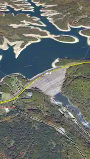
Scenic Map now covers the entire world via online maps. The maps are cached automatically so they can still be used when there is no cell coverage. Turn on Online Map in the Settings menu and you can then scroll or go to any location on the planet. Satellite image overlays add breathtaking detail and realism to the maps (tap preset 2 or 4 when Online Map is enabled). You can use them as you travel to see what is hidden from view at ground level. This takes moving maps to a whole new level.
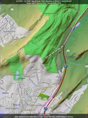
Use the two finger vertical swipe gesture to tilt the map for a 3D view. Scroll like a map or fly like a flight simulator. Enable Joystick Gestures in the Settings menu and then fly around the terrain using a virtual joystick. Prefer only 2D maps? Enable the 2D Map option in the Settings menu.
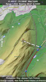
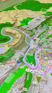
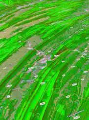
Scenic Map is simply the best 3D topo map available for a mobile device. You will see incredible detail while scrolling, rotating and zooming perfectly smoothly. You will see every road even if you zoom out to the altitude of a satellite. As you zoom in, you will see every small bump and hollow of the Earth and terrain features as small as ten meters. Unlike old fashioned topo maps, Scenic Map’s roads and trails are up to date thanks to OpenStreetMap.org. It contains polygons for urban areas, shopping malls, an ever growing number of buildings and many other features, The best lake, pond, stream and rivers from the USGS and Canadian public databases are also included.
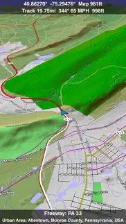
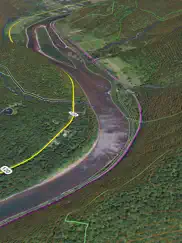
Tap the GPS center button to begin tracking your location. As you move, you will generate a track file. Tracks can be replayed with video like controls to speed up, slow down, pause, restart or skip to the end. You can display existing tracks while recording another if you want to retrace your route. When online, you can automatically create a route from your current GPS location to any other point on the map. Tracks can be received from or sent to other apps in GPX format. GPS recording stops automatically after you have remained stationary for some time or you can choose to manually stop tracking by tapping on the top track in the Tracks view.
Never before have maps been this customizable. For example, you can turn on or off the roads. You can change the lighting direction or remove terrain shading entirely. You can display contour lines even over satellite images. There are five presets which let you quickly switch between map styles. Use Metric, English or Nautical units and choose one of four different coordinate displays including UTM.
Want to learn more about a map feature? Tap the target icon and center the feature under the compass rose to display its name, type, urban area, county, state, elevation and coordinates. You will also see a bearing line back to your current GPS location or from your location to a selected waypoint. The status bar shows the bearing direction and distance along with the map and GPS elevation, the track length, and your current speed and direction of travel.
In-app documentation is provided in the Help section at the top of the Settings menu. Links are provided in the documentation to detailed coverage maps, tutorial videos, installation guide and blog at ScenicMap.com
Map data © OpenStreetMap and contributors under the Open Database License
Scenic Map supports GPS tracking while the app is in the background.
Caution: Continued use of GPS running in the background can dramatically decrease battery life.
😍 Do you love Scenic Map Eastern USA app? Please share your friends!

Please wait! Scenic Map Eastern USA app comments loading...
Scenic Map Eastern USA 1.9.2 Tips, Tricks, Cheats and Rules
What do you think of the Scenic Map Eastern USA app? Can you share your complaints, experiences, or thoughts about the application with GrangerFX and other users?
Scenic Map Eastern USA 1.9.2 Apps Screenshots & Images
Scenic Map Eastern USA iphone, ipad, apple watch and apple tv screenshot images, pictures.
| Language | English |
| Price | $4.99 |
| Adult Rating | 4+ years and older |
| Current Version | 1.9.2 |
| Play Store | com.grangerfx.ScenicMapE |
| Compatibility | iOS 16.1 or later |
Scenic Map Eastern USA (Versiyon 1.9.2) Install & Download
The application Scenic Map Eastern USA was published in the category Navigation on 01 April 2010, Thursday and was developed by GrangerFX [Developer ID: 363698835]. This program file size is 66.12 MB. This app has been rated by 6 users and has a rating of 5 out of 5. Scenic Map Eastern USA - Navigation app posted on 19 January 2024, Friday current version is 1.9.2 and works well on iOS 16.1 and higher versions. Google Play ID: com.grangerfx.ScenicMapE. Languages supported by the app:
EN Download & Install Now!| App Name | Score | Comments | Price |
| Scenic Map Western USA Reviews | 4.5 | 11 | $4.99 |
| Scenic Map Grand Canyon Reviews | 5 | 2 | Free |
| Scenic Map Central USA Reviews | 4.7 | 4 | $4.99 |
| You Need A Map Reviews | 4.2 | 46 | Free |
| Scenic Map Eastern Canada Reviews | 1 | No comment | $3.99 |
Fast initial download. Maps are then dowloaded automatically. Fixed track recording in iOS 17. Fixed the settings menu in landscape mode on iPhone. Fixed low frame rate when the information bar is enabled. The map's highest detail is now displayed while scrolling.
| App Name | Released |
| Parking.com - Find Parking Now | 07 August 2018 |
| Find My Friends Phone - iMapp | 26 July 2014 |
| Bonjour RATP | 14 May 2012 |
| Electrify America | 03 June 2019 |
| Find my Phone - Family Locator | 08 January 2013 |
Find on this site the customer service details of Scenic Map Eastern USA. Besides contact details, the page also offers a brief overview of the digital toy company.
| App Name | Released |
| Blitzer.de PRO | 03 August 2022 |
| CDOT Colorado Road Conditions | 21 October 2020 |
| Cincinnati Zoo - ZooMap | 26 October 2021 |
| MilGPS | 01 December 2010 |
| Light Pollution Map | 20 September 2020 |
Discover how specific cryptocurrencies work — and get a bit of each crypto to try out for yourself. Coinbase is the easiest place to buy and sell cryptocurrency. Sign up and get started today.
| App Name | Released |
| 09 October 2009 | |
| YouTube TV | 05 April 2017 |
| TikTok | 02 April 2014 |
| DoorDash - Food Delivery | 10 October 2013 |
| 05 February 2019 |
Looking for comprehensive training in Google Analytics 4? We've compiled the top paid and free GA4 courses available in 2024.
| App Name | Released |
| AnkiMobile Flashcards | 26 May 2010 |
| Monash FODMAP Diet | 17 December 2012 |
| Purple Place - Classic Games | 17 May 2019 |
| AutoSleep Track Sleep on Watch | 19 December 2016 |
| Suika Game-Aladdin X | 06 March 2024 |
Each capsule is packed with pure, high-potency nootropic nutrients. No pointless additives. Just 100% natural brainpower. Third-party tested and validated by the Clean Label Project.
Adsterra is the most preferred ad network for those looking for an alternative to AdSense. Adsterra is the ideal choice for new sites with low daily traffic. In order to advertise on the site in Adsterra, like other ad networks, a certain traffic limit, domain age, etc. is required. There are no strict rules.
The easy, affordable way to create your professional portfolio website, store, blog & client galleries. No coding needed. Try free now.
Scenic Map Eastern USA Comments & Reviews 2024
We transfer money over €4 billion every month. We enable individual and business accounts to save 4 million Euros on bank transfer fees. Want to send free money abroad or transfer money abroad for free? Free international money transfer!
Gives Topo maps depth!. Rather than using your imagination to read topo sas many of us have done for decades, this app allows you to feel like you are in a valley or on a peak. Excellent app.
Great Compliment to a Standard TomTom GPS in the Car. Used this fine application on a road trip this week along I-90 from NW PA to Chicago. I was driving through some of the most featureless landscape in the US, but I was amazed at the topographic detail shown on the map. I had no idea how many river valleys and lakes I had been driving by all these years. Consumer TomTom and Garmins are great for telling you how long it will be until you get there, but there is nothing like looking overhead from ten miles above, having the whole map rotate around your current location in 3D as you drive along. Yes, this app is relatively expensive compared to Angry Birds, but it's only half the price of a one-State gazetteer paper atlas and contains a lot more information on many States. I use a Dual XGPS150A bluetooth GPS (highly recommended) with a second-generation iPod Touch. The Dual GPS pulls in about 11 satellites at once and is much more accurate than my TomTom or my wife's iPhone. The Scenic Map App never bogged down on this old iPod, even while driving through Chicago, which has an incredible amount of detail. I would love to see how it works on one of the new iPads.
Great Topo. What hiker wouldn’t want a sharp topo that doesn’t require a cell phone signal? And not expensive compared to buying todos for the entire eastern third of the country! Handy and a great value.
new version crashes. Was very happy with the Original Scenic Map app which worked perfectly on my iPad1 ( sys v3.2.2 ) but I was tempted by great sounding features of latest upgrade so I installed it ( 1.8GB ) against my better judgement ( considering it was just released 2 days ago ). The upgrade does not run on my iPad even though it is advertised to be compatible, instead it crashes very well when I try to start it. Now I will probably suffer the crude process of reverting to the old version ( via iTunes ) so I can have a useable Scenic Map app again, or wait for the upgrade to be fixed. The other foolish option I won't try again is to upgrade my iOS just for the purpose of trying to get a new app to work. I advise anyone thinking about upgrading their iOS to make sure they research & understand the risks & possible time & money gobbling consequences they might face. Anyways I gave the upgrade one star because I liked the original App so much I thought it deserved six ( so I owed it one ). Please either fix the new version or else correctly advertise ( and warn previous version users ) which iPads it is compatible with.
Memory GUZZLER. 2GB just for update HUGE amount of memory required Does not do what I expected so I am deleting it and freeing up a lot of memory. I wanted to like this one because the maps reside ON the iPad but they don't work with ease as expected.
Has potential. It's neat to be able to visualize an area to hike but when you zoom in to a 100 acre lot or so, it blurs badly. It would be awesome to zoom in better. As we all know, the land may look fairly decent from afar. The current zoom level is good for mountain climbers. I need to better visualize gullies, inclines and such.
A Home Run. Am using with Pad 3G. These excellent maps are downloaded to your iPad and therefore don't depend on an Internet connection. Now you can tell what is below or near by when traveling. They must have been designed by a traveler because they show a lot of real good information most other maps don't like names of bodies of water and historical markers, etc. For the "wish list": would be nice if program could let you draw line / flight path between two cities, even if destination is not on map so you could get an idea of starting point to figure out where you are on map.
A map for the serious Adventurer. First of all, I used this app for navigating the Trans America Trail, from Tennessee to the Oregon coast. The trail itself consists primarily of unpaved and often unmarked roads. It did not disappoint. Over all I'd say that the maps was roughly 95% accurate, and rarely did a road not show up. A couple of two-track trails on the Utah/Nevada border, and the occasional dirt road. The 3-D view helped define terrain markers and locate points in a real world reference which aided us greatly while looking for an elusive unmarked turn. GPX files are easy to import, and being able to export breadcrumbs via email is fantastic. I've tried many of the offline maps for overlanding and this one has by far been my favorite for close to 4 years now.
Waste of money. Pretty AND pretty USELESS. No help; interface not very intuitive; colossal absence of major roads - e.g. US 95 not even shown ! You will get more value from a $10 bill by making it a paper airplane and sailing out a window. I would give it a zero if I could.
Navigation is messed up!. I bought this for a cross country trip based on the west map which impressed me. The east map navigation has numerous problems on my ipad2. It sometimes spins off in weird directions when I try to move left or right and then tries to sell me another map. Not cool!
It's good. It also took quite a while to download and install, but it works well. Only downside is that the road names don't always appear depending on how much you zoom in/out, but overall it's a handy app!!
Do not buy it !. Not worth 10$,maybe 99c at most,slow,not enough options.
Good Deal!. Highly Recommended. These Apps replace pretty much any paper maps you may currently carry. Both Streets and Topographic information are here (based on OpenStreetMap.org), plus the fact that you don't need any connection to view them, make this just the thing for the traveler/hiker. I started with the free Grand Canyon App, then bought the Eastern set soon after. I now have the Western set and will get the Central States set soon. Other than iBird, this is the most expensive App I own, and have found it to be well worth the money. Just compare the $ to any paper atlas. I have a Wi-Fi only iPad. I guess this App will track your location with the 3G/GPS unit, which I'm sure would be excellent. I am considering (much to my wife's dismay) trading up just for this App. Yes, this is a rather nasty download(1 gb+);don't even think of trying it with Wi-Fi. Get it via iTunes. While waiting for the download, make a quick read of the manual/blog/bugs on the developer's web page.
Great app! But.... Love the app and it comes in handy but I would prefer being able to easily drop a pin instead of using these unsightly stars.
valued app. fantastic app. well worth the $
Great App!. Just downloaded V1.3 and the app does everything advertised. Speed, features and resolution are great. Don't know what the negative fuss was all about is some previous reviews. My guess is that people are using an iPad2 wi fi (with no 3G =no GPS chip). I am using a Bad Elf GPS and the functionality is awsome. A good buy!!
Need to work with it. Just tried 1st time with about a short hike. Tracked well. Maybe I missed it, but would be nice to have more detail available for a Track, such as elevation change, speed..etc. Also it seems you need to "play" the track to see it. Be nice just to get an overview of the track on a single screen. Maybe these are available and I just haven't figured it out. Should be inst manual on the iTunes app site.
Love It! Works Great…Must Have when no Cell Service.. Love It! Works Great….Must Have when no Cell Service.
Big Disappointment. After paying $10 for maps east, it doesn't even compare to Google Maps (which is free) and shows a local neighborhood road incorrectly. Buyer beware!
Great app a bit complicated. Great app but requires some dedication to learn. It’s worth the time tho. Been using for several years for different scenarios. Always excels !!
Wow. This is exactly what I've been looking for...looks incredible on the iPhone 4. Great details, landmarks, etc. Well worth the $$
Best driving map ever!. I have been using this app for the past two years. It has continued to improve with several major updates over that time. I love using it while driving (although it is great for hikes as well and I know that pilots love it). I love seeing the terrain rotating as my car winds its way through mountain roads. It's simply icredible. It is the kind of moving map you would expect to see in the movies, not on the dash board of your own car. Several other users report that they don't like the 3D view in the new version. I also like the 2D view some of the time. That's why the program has presets buttons along the bottom of the screen. I can set one to be the 3D view and another to be a 2D view. A simple swipe gesture can tilt the map to whatever angle I want.. Get the map presets setup how you want before you drive and then you will be able to keep your eyes on the road and just tap the presets to switch views. This is not a navigation style map. Those are great if you want directions from point A to point B. You can run multiple maps at the same time and leave the navigation map running in the background while Scenic Map shows you the terrain ahead. You will still hear the voice prompts for upcomming turns. I prefer to have a separate GPS receiver so my iPad can play audio books in the background. Get this app and you will be wondering why all maps can't look this good? Sure Google maps are great but not when you are out of cellular range or have a low bandwidth. This one app covers a vast portion of the country and never uses any valuable wireless data.
Waste of money. No detail, no terrain, no roads, just a blank screen showing land and water and your current location.
Did you know that you can earn 25 USD from our site just by registering? Get $25 for free by joining Payoneer!
Imagine you at your best. All the time. Picture yourself at your sharpest and most productive. Your most alert and focused. Your most lucid, creative and confident. At work. At play. In every area of your life. Add Mind Lab Pro® v4.0 to your daily routine and uncap your true potential. Buy Now!
Adsterra is the most preferred ad network for those looking for an alternative to AdSense. Adsterra is the ideal choice for new sites with low daily traffic. In order to advertise on the site in Adsterra, like other ad networks, a certain traffic limit, domain age, etc. is required. There are no strict rules. Sign up!