You Need A Map App Reviews
You Need A Map App Description & Overview
What is you need a map app? If you get lost or in an emergency, YOU NEED A MAP! A map that covers the entire USA, all 50 states. A map that works everywhere even without a cell phone signal. A map that shows not just roads but also terrain, streams, lakes and other landmarks.
Note: If you would prefer a small app that caches online maps covering the entire world, please see the More by GrangerFX section below and try the free Scenic Map app. Get You Need A Map if you want an offline map the entire USA as a single large download. The paid apps have built in maps with full resolution terrain.
Your iPhone has a great online map but all it takes is one wrong turn and you could find yourself lost with no cell phone signal. What is the fastest way back to the highway? Should you go forwards or back? Is there a better road just a short distance away? Is there a raging stream or an steep cliff between you and the road? YOU NEED A MAP!
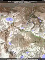
You Need A Map is a huge application. It has to be. It contains every mountain, hill, stream, lake, pond, freeway, highway, local road and track. In addition it contains many buildings, trails, railways, points of interest and polygon features. It has everything you need to find out where you are and what is around you anywhere in the USA.
Most navigation apps on the iPhone and iPad must transfer all their maps from servers on the internet. This can be slow in areas with only 2G coverage or completely unavailable in wilderness areas where a map would be most useful. You Need A Map solves this problem by storing maps directly on your iPhone or iPad. This extremely fast high quality software renderer is the first of its kind for mobile devices.
If you do have a cellular or WiFi internet connect, Satellite image overlays add breathtaking detail and realism to the maps (tap preset 2 or 4 when Online Map is enabled). You can use them as you travel to see what is hidden from view at ground level. This takes moving maps to a whole new level.
Tap the arrow in the toolbar to enable GPS tracking. As you move, you will generate a track file which you can replay. You can also import GPX tracks generated in other programs and play them. While recording or playing a track, the map will be centered on the current location and rotated towards the direction of travel and rendered in 2D or 3D with silky smooth animation. When playing a track, you can speed up, slow down, pause, restart or skip to the end. Send your GPX tracks to other apps or email them.
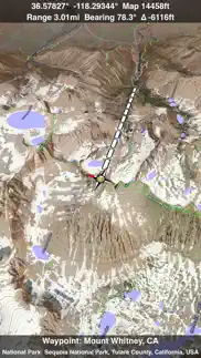
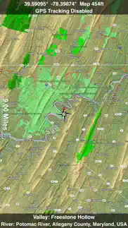
Want to learn more about a map feature? Click the target icon and center it under the compass rose to display its name, feature type, urban area, state, elevation and coordinates. You will also see a bearing line back to your current GPS location or from your location to a selected waypoint. The status will display the direction and distance along with the map and GPS elevation, the track length, and your current speed and direction of travel
You Need A Map uses the same code as Scenic Map and has most of the same features. These include many map customization options, customizable waypoints, direction and bearing information, a smooth scrolling moving map display while driving or flying, city search and much more. You can also get the full feature set of Scenic Map with an in-app purchase including the new online maps of the entire world.
Documentation, detailed coverage maps, installation guide and blog are available on ScenicMap.com
You Need A Map covers the entire USA including all 50 states
Map data © OpenStreetMap and contributors under the Open Database License
You Need A Map supports GPS tracking while the app is in the background.
Caution: Continued use of GPS running in the background can dramatically decrease battery life.
😍 Do you love You Need A Map app? Please share your friends!

Please wait! You Need A Map app comments loading...
You Need A Map 1.9.2 Tips, Tricks, Cheats and Rules
What do you think of the You Need A Map app? Can you share your complaints, experiences, or thoughts about the application with GrangerFX and other users?
You Need A Map 1.9.2 Apps Screenshots & Images
You Need A Map iphone, ipad, apple watch and apple tv screenshot images, pictures.
| Language | English |
| Price | Free |
| Adult Rating | 4+ years and older |
| Current Version | 1.9.2 |
| Play Store | com.grangerfx.YouNeedAMap |
| Compatibility | iOS 16.1 or later |
You Need A Map (Versiyon 1.9.2) Install & Download
The application You Need A Map was published in the category Navigation on 31 January 2011, Monday and was developed by GrangerFX [Developer ID: 363698835]. This program file size is 66.01 MB. This app has been rated by 46 users and has a rating of 4.2 out of 5. You Need A Map - Navigation app posted on 19 January 2024, Friday current version is 1.9.2 and works well on iOS 16.1 and higher versions. Google Play ID: com.grangerfx.YouNeedAMap. Languages supported by the app:
EN Download & Install Now!| App Name | Score | Comments | Price |
| Scenic Map Central USA Reviews | 4.7 | 4 | $4.99 |
| Blue Hound Reviews | 4.6 | 717 | $1.99 |
| Scenic Map Eastern Canada Reviews | 1 | No comment | $3.99 |
| Scenic Map Alaska Reviews | 4.5 | 4 | $1.99 |
| Scenic Map Central Canada Reviews | 1 | No comment | $3.99 |
Fast initial download. Maps are then dowloaded automatically. Fixed track recording in iOS 17. Fixed the settings menu in landscape mode on iPhone. Fixed low frame rate when the information bar is enabled. The map's highest detail is now displayed while scrolling.
| App Name | Released |
| EVgo EV Chargers | 17 October 2017 |
| Circuit Route Planner | 22 March 2017 |
| OnX Backcountry Trail Maps GPS | 09 December 2020 |
| KakaoMap - Korea No.1 Map | 27 February 2009 |
| PlugShare | 07 March 2011 |
Find on this site the customer service details of You Need A Map. Besides contact details, the page also offers a brief overview of the digital toy company.
| App Name | Released |
| Aprs.fi | 02 December 2015 |
| Jacksonville Zoo - ZooMap | 25 October 2021 |
| Bronx Zoo - ZooMap | 16 May 2021 |
| Sun Seeker - Tracker, Surveyor | 04 October 2009 |
| Solocator - GPS Field Camera | 09 December 2012 |
Discover how specific cryptocurrencies work — and get a bit of each crypto to try out for yourself. Coinbase is the easiest place to buy and sell cryptocurrency. Sign up and get started today.
| App Name | Released |
| 09 October 2009 | |
| Ralph Lauren | 08 November 2021 |
| Amazon Shopping | 03 December 2008 |
| 07 April 2016 | |
| 06 October 2010 |
Looking for comprehensive training in Google Analytics 4? We've compiled the top paid and free GA4 courses available in 2024.
| App Name | Released |
| Incredibox | 27 March 2016 |
| True Skate | 18 October 2012 |
| Terraria | 28 August 2013 |
| Poppy Playtime Chapter 1 | 08 March 2022 |
| HotSchedules | 30 October 2008 |
Each capsule is packed with pure, high-potency nootropic nutrients. No pointless additives. Just 100% natural brainpower. Third-party tested and validated by the Clean Label Project.
Adsterra is the most preferred ad network for those looking for an alternative to AdSense. Adsterra is the ideal choice for new sites with low daily traffic. In order to advertise on the site in Adsterra, like other ad networks, a certain traffic limit, domain age, etc. is required. There are no strict rules.
The easy, affordable way to create your professional portfolio website, store, blog & client galleries. No coding needed. Try free now.
You Need A Map Comments & Reviews 2024
We transfer money over €4 billion every month. We enable individual and business accounts to save 4 million Euros on bank transfer fees. Want to send free money abroad or transfer money abroad for free? Free international money transfer!
Awesome free gps mapping!!!. This is a free gps map app that you can use while you are offline. I use it for off-roading, flying, hiking, fishing and mountain biking. Most map apps require you to be online which is useless for what I need a map for. If you just need directions to the grocery store, this is not for you. This app is quite large because you download all the maps to your device. I've used it on both my iPhone and iPad and it works great. Thanks for the great app!
This app rocks!. I can't say enough good things about this app. I've been using it while hiking in remote locations and it is awesome to be able to have a map combined with GPS while off-line. The maps are very high-quality with details of backroads and hiking trails even. Highly recommended!
You Need a Map. Used to be better at pointing out natural landmarks. Example, I used to be able to slew over and it would name rivers and lakes. Now when I slew it persists in naming what county the slew pointer is in. Even major rivers it will not name like it used to. County identifiers is turned off. I could care less what county I am flying over. All other improvements are a plus. I really like the track data display.
great map to have in usa. this is a surprisingly good application for iphone..it is a big program though at 1.9 Gb or so but that is because it has an excellent map of the USA. So it can be useful to have as reference like an atlas in your back pocket..but that part i really like is that it is also a gps tracking tool, which will save tracklogs as gpx files which you can collect and view with other dedicated programs like topofusion etc..it's well worth the extra memory on my 16 Gb iphone 4s... *note added later..i'd like to ask a request of the developers to make this app just a little bit better...typically any gps unit takes perhaps a minute or so obtain a good signal for location data, i wish that some kind of status icon or other could be put onto the screen...that way the user can wait that minute or so before starting a trip (bike, car, whatever)...so that the shole trip is caught on the track, if you leave before signal then you loose that part...hopefully this is not too much trouble to insert in a sebsequent version...thanks so much for the useful program!
An offline map of USA in your pocket. I love this app and highly recommend this app. Each family member Carrie’s this on their phones for those just in case times you can’t get a signal for typical online only maps. In addition, it has lots of features for exploring areas and seeing the terrain near you. It helps me plan photography shots too! You can turn on 3D view, put up an imaginary sun, and see where shadows vs sunlight will be. Just an excellent map app.
Awesome. Great map app!
If you're into maps, This Is It!. After several emails back and forth to Mark, I'm convinced he's in this project for the long haul. He has taken the incredible depth of the Open Street project and has placed it onto your iPad, iPhone, etc. -- without the continuous need for an internet connection. The interface is very clean and intuitive, and I highly recommend this app for basic navigation, and browsing. Try it, and I think you'll agree. Really looking forward to the next iteration!
Useful for what it is. Wonderful off-line map; very handy in those cases where you have poor data service to work with the GPS! Nothing super-fancy about the maps, but that doesn't seem to be its primary use.
Fantastic...but. What an amazing app. I don't have a 3G connection on my iPad, so I need an app like this to help me navigate. I use it like a traditional paper map, except that i can zoom in when ineed to (if lost). The only reason I took off 1 star is because the names of the streets and avenues are not aligned with their corresponding roads. This is a problem when you get into areas like NYC, where the grid is laid out at an angle. You can't be sure which road the name refers to; however, for the price, I can't complain.
Dark Mode glitch. Hey developers, When using dark mode, all alphanumeric values in ‘tracks’ will not display. The portion of tracks that I can edit will only display emojis and nothing that I have written or what is programmed to be there prior to edit. The bottom segment of tracks that I can’t edit remains visible in either mode. Just thought I’d let ya know😎
5 star 5 star 5 star. I fly helicopters and alot of different areas where there is no service and this app has a full topo map of the whole USA. Very valuable when I need to no roads, creeks, or even points of interest. I look forward to the future of this app.
It's a Map not a way to Navigate. It's a great map and includes terrain not available on a typical road map but you can't search for an address and be presented a route. It also has stale map data. I've lived in my house for 4 years and I'm not on the map. I'll keep it for emergencies but it won't get much use when I'm driving. Free is good, for that reason 3 stars.
Useful!. Professionally made app, easy to understand and use. I've been waiting for something like this app. Incredibly useful and well-designed app with great UI/UX! Thanks:)
Thanks. I like the user interface, very easy and intuitive! Thank you for the app!
Great for back road travel. If you just need city and big highway maps then download anything. They're all the same. BUT if you get off-road or deep into the back country GET THIS APP. I've tried many. This beats them all.
Great to have a map of the US in such detail - all for 99 cents!. What a great app! Download the database so you have access to an entire hi-resolution map of the US, even when not connected to the Internet! Great detail, allows excellent rendition of the contours with variable sun position. Rivers and Streams, Contours, Points of Interest, Essentially every road in the entire US. File size is 2 GB - not bad for such detail!
Outstanding Customer Service. After having issues with trying to import GPX files, Mark Granger was prompt and in depth with his correspondence trying to fix the issue. The app itself is a great overall offline map. I've used it on both cross country flights, and on trails. Lots of great POIs, including many in my local area that I didn't even know about. My only complaint is that is not the most user friendly at times, and it's not very intuitive, but I feel this could be helped with a good user's guide somewhere within the app itself.
Free detailed US maps, always there? Amazing.. This app was worth $10 to me when it first came out, even with 1/3 of the mapping info. I've used it enough times and in enough situations to say that it has not only paid for itself, but also the iPhone. Having an always available detailed map of the U.S., with GPS … what can I say? It's the main reasons I got a higher-memory iPhone.
Can be very helpful. I got lost once in the woods returning from hunting at night. This app helped me navigate my way back out of the woods. I love the option of tracking where you have been so you don't backtrack.
Great offline navigation!. Excellent! Just used this app on a scenic mountain drive. Not having to worry about losing date in the mountains is a great piece of mind and the 3D topo greatly enhances situational awareness. I also find not using turn by turn directions to be less intrusive, especially for a spontaneous drive. Just use the GPS location and the ground track to make sure you don't make a wrong turn somewhere. Can't wait to take this hiking.
Excellent update for an excellent app.. The latest update is great! You can add GPX files directly from safari downloads via the share sheet. I couldn’t be more impressed with the app. I really appreciate the customer service. Prompt responses to emails and delivering the goods World class work. Thank you
Ignore negative feedback this app is great. it is free, downloaded in about 20 minutes i don't know how much space it take i carry a 64gb so i don't care but this app is great just get will be useful wen ending up at a location with no service wifi etc. Just get it
Exactly what I wanted!. I have an iPad mini withOUT cell connectivity, and am therefore dependent upon having access to wi-fi to use googlemaps or similar--not so helpful when I'm out and about. I also don't have a smartphone. So, what I really wanted was a road atlas I could use on the go. This app provides that and so much more! (FYI--I just have the free app; no fancy-schmancy 3D upgrades or anything.) I've only had it a little while, but I'm confidant it can provide whatever map info I need, anywhere in the continental U.S. (maybe Alaska and Hawaii too, I just haven't looked). I can zoom in or out to whatever level of detail I need and the road/place names adjust to my new level. The "so much more" aspect is that, while I would have been happy with a simple road atlas, this app also shows topography and features, both natural and man-made. Great info! I do get the feeling all this quality is using up a lot of memory, but for me, it's worth it.
It works fine out of cell phone range. It is an offline map. It works fine when you are out of cell phone range. You do not need gps signal to use the map, you only need gps signal to update your location on the map. If you have a cell phone model device that does 3g or later, then you also have a built in gps. If you don't have a 3g or later device, you can still do gps with a bluetooth device like bad elf pro. But even without a gps the map still works, though you have to figure out where you are. All of the street names etc still show up, as do the topo lines.
Weak. Ultimately it is a nice interface for the open source OpenStreetMap data which is a decent offline map. But the app advertises itself as an offline map with GPS. I don't know how it is maybe intended to work, but it fails for me as an offline GPS map. The few times I tried it, the GPS function simply doesn't work when I'm offline. It only has been working for me when I'm in wifi range. Otherwise I get a "GPS function unavailable" error message. But if I'm within wifi range, I might as well use the built-in Google Map since it a much better overall map anyway. I looked at the developer's page but that was no help. Nothing about that problem (if it is a problem and not an intended design feature) in the FAQ or known bugs pages.
Outstanding maps. I jail broke my iPad so I could use a bluetooth gps receiver. I spent my vacation on Lake Mead and was astounded at the detail and route help this app provided. Navigating the coves and channels was made very simple and hiking after beaching was exhilarating knowing this app could tell me what the surroundings were and where the best views were. There was never a worry about returning to the boat. I love this app.
Need retina display for the new iPad please. Dear developer, can you please add retina display graphics for the app called "you need a map" it would be great because my new iPad or might as well call it the iPad third generation would need good graphics for this app I find this app very useful and I would love to have a nice clear sharp map on my new iPad so thanks and please take this note under consideration. Many thanks
Works well offline. This is not the most beautiful app I've seen, but it does exactly what it says. Five stars
Awesome app. Really useful app with great design. Highly recommend!
Folks, it's a full on US map. every small garage map for local areas all in one place, with no need for cell-service or wifi. You're virtually storing close quarters google maps for the entire US, accessible anywhere, any time. Only makes sense. What on earth could be better use of space if you prefer small adventurous ways highways and freeways? I may add on the 3D, I think it may well be worth the 2 clams (less than one starbucks plain brewed coffee)… we'll see…..
When You Need a Map, You Need it Badly!. Great map. Being able to download and store a high quality map for use in remote areas is great. I also had my buddies download it too so we can all use the same system. Being able to switch to the UTM system is fantastic. This is one of my favorite apps!
No good for out-of-cell-range. Seems to work 'ok' for in-city stuff, but then why? Since in-city 99% of the time you'll have 3G or wi-fi ... and use a 100x better app. Tested this for some off-highway out-of-cell-range areas, and the maps are honestly pretty worthless, lacking most road info and expecially any forestry service roads which I'd imagine are pretty well known (at least in other apps I've used). Better off to just use a different app and pre-download areas before traveling if heading out of cell range. The 3D looks kinda cool, but again it's weak compared to other more solid apps like Maps 3D. Sorry, I usually don't complain on $3.00 but this was a waste of time & space for me.
Awesome. I'm a Commercial Pilot and purchased an iPad 3 in anticipation of our company approving our charts and approach plates for use on our pads. In the mean time I wanted to have fun with my iPad 3 while commuting to and from my base so I purchased an Ultimate GPS unit which works great but wanted a moving map app to see where I was over the US. You Need a Map app recognizes the Ultimate GPS unit and gives you Lat, Long, Altitude, Speed and you can watch your progress over the ground. To my surprise this app works well with the Ultimate GPS. This is an amazing app!!
Name says it all. I know if I have this app on my phone and my phone in my pocket I can just start driving down a new trail some where in the bush and use this to get back later.
Excellent. I’ve used this flying across the country as a pilot and in the mountains hiking. No cell signal needed and the ability to leave a track so you can follow it back out.
Fabulous!. For free, you can't beat the functionality of this app. The only possible downside is the size, especially for the smaller capacity idevices. We used it for a trip from CO to CA, performed flawlessly. Highly recommended, especially for folks with limited data plans.
It's FREE!. It's a free app and is very useful for those that don't have 3G or a wifi available. If you want glitz and glam go with google. Those stuck with no connection will use this and be better for it! Thank you!
Great App !. What a great app. Seems to match up with mu gps mapping software so it looks to be very accurate. The issue with street names being sideways is easily compensated for by moving curser over the street and the name shows up.
Great app could be better. I love that this app is free! I also love that it can work without any Internet connection. My only complaint is that it is out of date or something. My whole subdivision doesn't even show up. I can find where it should be, but it's not there. Our subdivision has been here for more than 5 yrs now. Some of the street names in other places don't show up either or are out of date also. Overall, thou, a great app.
Isle Royale, MI. Great app. But where is Isle Royale, Michigan? The roads are there but the island is missing.
It just works. After searching high and low for a good offline map for my 2G iPod Touch I found this gem. After a moment to adjust the settings to my liking (map shading, etc…) there is nothing I can really get nit-picky about. Though I wish the bike paths were a bit more up to date, and I did find an error on a road name - but to be fair not many people know the names of obscure logging roads in Upper Michigan and the bike path in my town is pretty new. In short, this is a US atlas in an iPod with the level of detail of a plat book. Top form Mark Granger PROS: free, an efficient UI, finally an adjustable map output, stable, fairly quick between zoom settings (use the +/- buttons). CONS: not worth getting worked up over.
Fantastic!. This is a helpful little app to have around. It is actually one of the apps that swayed my decision to buy an iPod. I think that most iPhone users don't realize how helpful it is to have a great offline map database like this for us iPod users that cant always be on the grid. Great job guys!
Joe Pilot. Ditto on the update not loading. Really like the app though and I'm sure a fix will be soon as I'm looking forward to the new features. A bit more intuitive user friendliness will be welcome. The best feature is that the maps are loaded onto my machine and do not have to come on the server. This is one of the very few map programs that I can use in a plane, out of the reach of any cell coverage.
You need to have this map!. Every well-prepared person needs to have this map. Also note it takes 3 1/2 GB of space.
Exactly what we needed!. We wanted detailed US maps that were local to the iPad and would not require connectivity when we are out of range of anything. This app is perfect. Great maps, great features. Can't wait to take a road trip with this!
I concur with the confusing street names posts. This app does have a lot of potential for those people who have the smallest iphone data plan and worry about data usage. This map is very fast loading and scrolling even with all of the map options set to on (like points of interests, waypoints, shading..etc). However, while the horizontal streets are perfectly fine in the labeling, it's a struggle to figure out what the names are of the vertical streets since all the street labels are stated horizontally. Otherwise, I like this app a lot, even if it is nearly 2 gigs. (Note to people who want to find Hawaii's cities: you have to insert "honolulu" as the city name and then scroll from there.)
Nice. It's really nice to have a full US map on the device when you're out of cell range or just don't want to burn up data for idle map browsing. The gpx import from Dropbox is really nice also. The ability to edit how the map displays (such as reducing the opacity of the color of parks etc) is a nice feature. Glad I stumbled across this app.
What an awesome app. I've used this app many times when I was without cell coverage (Big Bend Nat'l Park, Glacier Nat'l Park, Buffalo Nat'l River and more) and it's very helpful. Many thanks to the author for providing what is actually a great public service - a detailed map of the United States with GPS tracking and no cell coverage needed. Awesome app!
More useful than I imagined. I was aware this was a monster file and questioned whether to keep it on my iPad, just to conserve bandwidth devoted to upgrades. I didn't seem to have an actual use for it, other than general map geekery. Then I wound up on the coast of northern California with no internet connection, trying to figure out where it would be OK to drive a largish RV. No "phone a friend" here. YNAM to the rescue. Located our position and provided great detail on our options. I'll never leave home without it again. That said, I only gave it 4 stars because it can be so much more. Three specific improvements come to mind. First, every screen should have roads identified, no matter what the zoom level. Second, tiny type is unreadable. There should be a minimum size that will be displayed, no matter what the zoom level. Third, some way to highlight roads or points of interest, maybe make this road, say CA-1, always show as pink until I change the highlight to US-101, then it's pink. Just a thought. Then you could dream about route planning capabilities, with saved routes and all manner of optimization tools. I really do need that map. All said and done, a really useful tool, with room for growth. Think I'll go download the 3D Mapping capability.
Powerful tool for Helicopter Search & Rescue. UPDATED 10-AUG-2018: I LOVE THIS APP- I’ve been utilizing this app as a back up (honestly, primary) to the onboard navigation equipment on a Navy MH-60S specifically for SAR Ops and identifying names and locations of local landmarks, roads, and popular trails such as the Pacific Crest Trail which is well marked within the app. UPDATE: I've also used all over the Pacific, midway, Japan, Indo, Vietnam, Singapore, Sri Lanka, PI, Indo-Asia area with zero issues. I've found that if I know where I'm going ahead of time, I'll get on Wi-Fi or data and conduct a map study, zoom in, and then cache the maps with the necessary zoom in detail as required for my flight missions. The only downside to this app is that it requires around 2GB of memory on your device to store the 3D maps (UPDATE: I got a new phone so memory is no longer an issue). But for what I do, even if I was limited on memory, I’m more than willing to give up that space on my phone/ipad for this app and the cached map data. Although I give it 5 stars, there is always room for improvement. For instance, I've got a lot of stored waypoints. I'd like to be able to prioritize my favorite waypoints towards the top of my list instead of having to scroll all the way to the bottom just to access my most frequently used ones. (If there is a way to already do that, I haven't figured it out). Also, I'd like to see the satellite imagery updated. For the price of the app and In-app Purchase, this is the best tool for the SAR community that I’ve used so far. I’ve paired my phone with a Bad Elph GPS Rx’r for better SAT reception when the phones onboard Rx’r just won’t cut it. The app eats up battery quick so when using it for extended searches/Nav, make sure you’ve got an external battery.
Did you know that you can earn 25 USD from our site just by registering? Get $25 for free by joining Payoneer!
If you have a free 2 GB on your device then I recommend you check this out. For a USA map, this has to be the best I have seen. Sure there is an in-app request to purchase more detailed maps, but for a straightforward free look at the place you cannot go wrong.
Imagine you at your best. All the time. Picture yourself at your sharpest and most productive. Your most alert and focused. Your most lucid, creative and confident. At work. At play. In every area of your life. Add Mind Lab Pro® v4.0 to your daily routine and uncap your true potential. Buy Now!
YNAM. The best in Canada AND elsewhere.
Doesnt work in Canada.. Booooo! Wish it would have said that before I downloaded 1.8 gig not to mention I had to clear over 5 gig just to get it to download. Doesn't deserve the whole star.
Adsterra is the most preferred ad network for those looking for an alternative to AdSense. Adsterra is the ideal choice for new sites with low daily traffic. In order to advertise on the site in Adsterra, like other ad networks, a certain traffic limit, domain age, etc. is required. There are no strict rules. Sign up!
I like what I see.... Lots of info, nice look, too! BIG file, took over 30min to download.
Doesn't install and can't delete!!!. It's been trying to install for 2 months on the latest iPhone 4s. The worst part is I can't even delete it while it whirls around in outer space
Beware! This is an almost 2 GB app.. If you have a 16 GB iPhone or iPod Touch you can forget this app. Remember, you lose about 3.5 GB of your device's memory before you download a single app to accommodate iOS 5, etc. Deduct close to 2 GB for this app and you are only left with 8.5 GB of memory on your device. A 32 GB iDevice is a minimum. IMHO . This app would be much more useful if you could select what part of the country for which you wanted to download maps. That could dramatically reduce the amount of memory consumed by this app. Some commenters have expressed disappointment over the resolution of the maps and the placement of the text. I would agree. However, more resolution would mean an even bigger app! I would much rather be able to download maps for the regions of the country in which I am interested and have them be at a higher resolution than have to download maps for the entire country at a lower resolution. Of course, having maps onboard your iDevice is a two edge sword. Yes, it gobbles up a lot of memory. But, it takes very little time to get your maps on screen and you use none of your precious monthly data allowance to do so. You also don't need to worry about having good cell reception to get your maps. In fact, you need no cell reception at all. This is a big plus for "You Need a Map." I give this app 3 stars. If the resolution of the maps were improved, the data (roads, houses, etc.) were more up to date, and the customer could select the regions of the country to download it would be a 5 star app.
No 3d. The program will not allow me to buy the 3d feature (ain't that a hoot) offered for sale. It always says the App Store is not available now.
Great help while flying. As an airline pilot, I use this to help find points of interest to passengers while flying across the country. I would like to see less clutter and include Canada.
Awesome!!!. Why can't more apps be as useful as this one?
What I've been looking for!. I love this map app! Just wish it had BLM and state trust land polygon overlays. That would make it absolutely perfect, and change my rating from 4 to 5 stars.
You Need a Map. The app is crashing every time I touch the GPS icon to center the map.
Great map for iOS. A friend of mine used this to show where we were on marked trails in Yellowstone. No cell phone coverage and no problems in use. It also told us altitude and how far we walked. I know there is some error due to GPS but wow.
3D Maps. I love this app the only issue I have is NONE ! ! ! ! It's the only 3D map App the works as advertised I've tried 4 so far as this one works off-line it's great with my I-Pad and I-Pad Mini
Most useful app I have. This app works equally well in the airplane, auto and on foot. No concerns with cell data useage!
wow. I really like this app. It is so well thought out and the maps are stunning. I have seen software like this package for hundreds of dollars. Those are not as well thought out like this.
Houston We Have A Problem. I'm a prospector and thought this would be a good app for finding creeks, rivers, and roads in the State of Oregon. It seems like this app has all the bells and whistles but it couldn't even find Albany Or USA or Cottage Grove Oregon or lakes such as Dorena Lake or creeks such as Brice Creek or Brice Creek Rd all in southern Oregon just off of I5. I promptly removed it from my iPhone and for those reasons I give it 1 star. Even though it's free for me it's not helpful at all. Thanks but no thanks.
WOW. We love this app. Used it all the way from Arizona to the Canadian border. Better than paper maps any day!!! Thank you so much. How about extending it into Canada?
Something is wrong. New update will not load.
Fantastic!. I use this with my 4th Gen. Itouch and a GPS cradle. Terrain and roads were spot on In Arizona. I used it scouting and camping in a new area with amazing accuracy and success.
Very interesting. This app provides offline maps. When you go to rural area, you sometimes can not access the internet. Yes, it could be helpful.
Frustrating. Never could get the app to download! This is the first time I've ever had any download problems on any app, free or paid for. I tried several times with no joy. so now I'm back looking for another off line atlas.
Poor.. The maps are so hard to read it is almost useless.
Only if you don't have acess to any other map.. Gas Buddy and Free WIFI Finder have better maps than this does.
Awesome. Has helped me get around a lot of back roads.
Lots of potential!. This app has lots of potential but until the names of the streets that run vertically are also displayed vertically, I'll stick with a similar free app that uses about half the memory. Fix this problem and I'll update this review to five stars. So for now, this app is pretty useless!
Awesome. This map is awesome. If people give this a bad review it's more a reflection of their intelligence and ineptitude.
For real, this is absolutely fantastic!!. I cannot thank the author enough for making the openstreets data so easily usable on the iPad in an offline mode. VERY well thought out and executed. THANK YOU!!!
Not as good as Topo Maps. Only three stars because it doesn't compare to Topo Maps for accurate detail off the beaten path (layered topics). I'll use Google for highway and download Topo Maps for the sticks. Still, if you travel a lot without an Internet connection, then this app might help you out.
Terrible Maps. The maps are virtually useless: 1- the text used is far too large and does more to obstruct the view than it does to help. 2- all the text is oriented horizontally and oversized leaving you to guess at which text goes with which street. 3- The "buildings" shown on the maps are little more than sat view outlines with no reference or naming for parks, malls, etc. 4- The paid versions offer no benefit over the free maps so download the free first, If those serve your purpose, you may be ok with the substantially overpriced paid versions of this app. DISAPPOINTED
Bad app. This is a horrible app. We used it on a road trip on the east coast and deleted it by the end. It is not searchable by town, road, city etc. If you move the map or zoom in it takes 5-10 seconds to reload-a long time if you must choose an exit/bridge/highway. The graphics are also ugly, looking like the original version of Civilization 20 years ago.
2nd best. Terrific ap. But still not as good as google maps.
WAS good.. After latest update, it will not open.
Engine 665. What a great app. Works well with out cell service. Use it all the time. Complete maps are great.
Decent, but way too large filesize.. If I could pick and choose exactly which parts I needed, it might be better. Also, other map apps do a better job of loading the data, scrolling, etc...
perfect. i just used it today when I was trying to find the way to a lake. amazing if you don't have 3g data. only thing is they don't have buildings
Map nut. Great app. Can't believe it's free. Even works great with my Bad Elf GPS so I can use it as a moving map offline.
You Need A Map. I can't get to even open. It just crashes. Would love for it to work.
Nice app, very good detail. Very nice app. Works nicely. But, I do agree with the reviews about the manner in which the streets are labeled. It makes it very difficult to read. Otherwise, a five star app.
Excellent on-device map. No external connection required, great detail. Other than a slight hiccup interfacing with the "scenic" add-on maps, it is very smooth. Overall an excellent map pgm!
Great. Works great on my 8 gig iPod touch & my unlocked 3GS. Have no data plan. Works good with gps when away from wifi.
Great app!!!. Well worth the large size.
To busy. This app is way to busy. Clutter and not easy to read. I think the map that comes with iPad is much easier to read and use. Just way to much info and fonts and orientation create confusion and clutter
Crashes!!!. I'm sure this app would be great of you could get it to open.
Good for travel. Secure your maps during your trip. It could rescue your life! ⛑
Watch out!. Be careful about downloading this monster! It's 1.8 GIG's and has so far tied up my computer with the download for two hours. At 5 - 10 times the size of other apps I can find better use of my memory.
You need a Map!. Great app. I can load the entire US road map without using any bandwidth. When you travel off the beaten path, you'll be glad you got this app!
Works great!. Can use map without data. Not a navigation app, but a map app with gps so you will know your location even when no data signal. Could be a lifesaver. Keep up the great work.
So glad I found this. Very useful app, this is exactly what I was looking for! So happy!
Not so good. Overall product leaves much to be desired. As stated before in the reviews the text is badly placed and to large thus obstructing the view of the already low quality information sparse map.
Routing directions. Fabulous!! Coming from a gis guy. Please give us network routing directions!!! Great job.
waste of time and space. this app is a horrible waste of 2GB on my device and my laptop (because iTunes keeps a copy of it)! the maps are very slow, the panning is hyperactive, and the UI doesn't make any sense to me...
Great app! Easy to understand and use!. Great app! Easy to understand and use! David Lorea Farrington
N/a. Unbelievable!!! The best map app I've used to date and can't see any that will come close, excellent job guys!!