Scenic Map Central USA App Reviews
Scenic Map Central USA App Description & Overview
What is scenic map central usa app? A 3D topo map of the Central USA. The vector map data is contained within the app and can be used without an internet connection. Use it in a car, a boat, a plane or while hiking. It is like having more than a third of the country in your pocket.
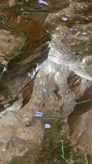
Scenic Map now covers the entire world via online maps. The maps are cached automatically so they can still be used when there is no cell coverage. Turn on Online Map in the Settings menu and you can then scroll or go to any location on the planet. Satellite image overlays add breathtaking detail and realism to the maps (tap preset 2 or 4 when Online Map is enabled). You can use them as you travel to see what is hidden from view at ground level. This takes moving maps to a whole new level.
Use the two finger vertical swipe gesture to tilt the map for a 3D view. Scroll like a map or fly like a flight simulator. Enable Joystick Gestures in the Settings menu and then fly around the terrain using a virtual joystick. Prefer only 2D maps? Enable the 2D Map option in the Settings menu.
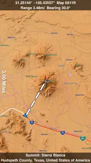
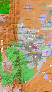
Scenic Map is simply the best 3D topo map available for a mobile device. You will see incredible detail while scrolling, rotating and zooming perfectly smoothly. You will see every road even if you zoom out to the altitude of a satellite. As you zoom in, you will see every small bump and hollow of the Earth and terrain features as small as ten meters. Unlike old fashioned topo maps, Scenic Map’s roads and trails are up to date thanks to OpenStreetMap.org. It contains polygons for urban areas, shopping malls, an ever growing number of buildings and many other features, The best lake, pond, stream and rivers from the USGS and Canadian public databases are also included.
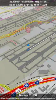
Tap the GPS center button to begin tracking your location. As you move, you will generate a track file. Tracks can be replayed with video like controls to speed up, slow down, pause, restart or skip to the end. You can display existing tracks while recording another if you want to retrace your route. When online, you can automatically create a route from your current GPS location to any other point on the map. Tracks can be received from or sent to other apps in GPX format. GPS recording stops automatically after you have remained stationary for some time or you can choose to manually stop tracking by tapping on the top track in the Tracks view.
Never before have maps been this customizable. For example, you can turn on or off the roads. You can change the lighting direction or remove terrain shading entirely. You can display contour lines even over satellite images. There are five presets which let you quickly switch between map styles. Use Metric, English or Nautical units and choose one of four different coordinate displays including UTM.
Want to learn more about a map feature? Tap the target icon and center the feature under the compass rose to display its name, type, urban area, county, state, elevation and coordinates. You will also see a bearing line back to your current GPS location or from your location to a selected waypoint. The status bar shows the bearing direction and distance along with the map and GPS elevation, the track length, and your current speed and direction of travel.
In-app documentation is provided in the Help section at the top of the Settings menu. Links are provided in the documentation to detailed coverage maps, tutorial videos, installation guide and blog at ScenicMap.com
Map data © OpenStreetMap and contributors under the Open Database License
Scenic Map supports GPS tracking while the app is in the background.
Caution: Continued use of GPS running in the background can dramatically decrease battery life.
😍 Do you love Scenic Map Central USA app? Please share your friends!

Please wait! Scenic Map Central USA app comments loading...
Scenic Map Central USA 1.9.2 Tips, Tricks, Cheats and Rules
What do you think of the Scenic Map Central USA app? Can you share your complaints, experiences, or thoughts about the application with GrangerFX and other users?
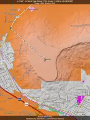
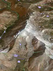
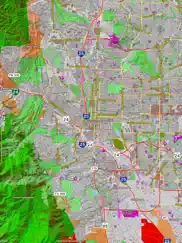

Scenic Map Central USA 1.9.2 Apps Screenshots & Images
Scenic Map Central USA iphone, ipad, apple watch and apple tv screenshot images, pictures.
| Language | English |
| Price | $4.99 |
| Adult Rating | 4+ years and older |
| Current Version | 1.9.2 |
| Play Store | com.grangerfx.ScenicMapC |
| Compatibility | iOS 16.1 or later |
Scenic Map Central USA (Versiyon 1.9.2) Install & Download
The application Scenic Map Central USA was published in the category Navigation on 01 April 2010, Thursday and was developed by GrangerFX [Developer ID: 363698835]. This program file size is 67.15 MB. This app has been rated by 4 users and has a rating of 4.7 out of 5. Scenic Map Central USA - Navigation app posted on 19 January 2024, Friday current version is 1.9.2 and works well on iOS 16.1 and higher versions. Google Play ID: com.grangerfx.ScenicMapC. Languages supported by the app:
EN Download & Install Now!| App Name | Score | Comments | Price |
| Blue Hound Reviews | 4.6 | 717 | $1.99 |
| Scenic Map Central Canada Reviews | 1 | No comment | $3.99 |
| Scenic Map Eastern USA Reviews | 5 | 6 | $4.99 |
| Scenic Map Western USA Reviews | 4.5 | 11 | $4.99 |
| Scenic Map Grand Canyon Reviews | 5 | 2 | Free |
Fast initial download. Maps are then dowloaded automatically. Fixed track recording in iOS 17. Fixed the settings menu in landscape mode on iPhone. Fixed low frame rate when the information bar is enabled. The map's highest detail is now displayed while scrolling.
| App Name | Released |
| Citi Bike | 21 May 2013 |
| OnX Backcountry Trail Maps GPS | 09 December 2020 |
| Neshan Map | 04 May 2023 |
| Volta Charging | 11 June 2015 |
| EV Connect | 09 June 2017 |
Find on this site the customer service details of Scenic Map Central USA. Besides contact details, the page also offers a brief overview of the digital toy company.
| App Name | Released |
| MilGPS | 01 December 2010 |
| Sun Seeker - Tracker, Surveyor | 04 October 2009 |
| Cincinnati Zoo - ZooMap | 26 October 2021 |
| NavRules | 07 March 2011 |
| Theodolite | 30 November 2009 |
Discover how specific cryptocurrencies work — and get a bit of each crypto to try out for yourself. Coinbase is the easiest place to buy and sell cryptocurrency. Sign up and get started today.
| App Name | Released |
| YouTube TV | 05 April 2017 |
| Amazon Shopping | 03 December 2008 |
| 12 February 2019 | |
| Google Chrome | 28 June 2012 |
| Ralph Lauren | 08 November 2021 |
Looking for comprehensive training in Google Analytics 4? We've compiled the top paid and free GA4 courses available in 2024.
| App Name | Released |
| Terraria | 28 August 2013 |
| 75 Hard | 19 June 2020 |
| HotSchedules | 30 October 2008 |
| Procreate Pocket | 17 December 2014 |
| Geometry Dash | 13 August 2013 |
Each capsule is packed with pure, high-potency nootropic nutrients. No pointless additives. Just 100% natural brainpower. Third-party tested and validated by the Clean Label Project.
Adsterra is the most preferred ad network for those looking for an alternative to AdSense. Adsterra is the ideal choice for new sites with low daily traffic. In order to advertise on the site in Adsterra, like other ad networks, a certain traffic limit, domain age, etc. is required. There are no strict rules.
The easy, affordable way to create your professional portfolio website, store, blog & client galleries. No coding needed. Try free now.
Scenic Map Central USA Comments & Reviews 2024
We transfer money over €4 billion every month. We enable individual and business accounts to save 4 million Euros on bank transfer fees. Want to send free money abroad or transfer money abroad for free? Free international money transfer!
Scenic Maps Great for the Price. First, I totally agree with the description listed by the seller. His preview screens show what you can expect, and the app does what he says it will do. Likes: Roads stay on map when zooming out, big plus Several preset views (5) Off line, great when your 50 miles from a cell tower Great detail, terrain, roads. I bought the Western US, I travel back roads in Utah, WY, and CO, Just bought Central US, more roads I travel often. Dislikes: Huge local file size, but worth the wait downloading if you need offline access. I've got the 64 Gb; 16 Gb users may not have the free space (plan on 4-5 Gb/area) Recommend to a friend: Yes Primary used on iPad, may load on iPhone to try GPS functions Use: I have 7-8 other map apps, topo, GPS, Nav, etc, this map has smooth scrolling, fairly fast refresh (iPad 3rd Gen), smooth terrain features, 3D feature is nice. Best feature is small dirt roads don't disappear when you need to zoom out. One giant download and you've got 1/3 of the US in your hands, well worth the price. This app makes paper Atlas obsolete 💯 I have not used this with or for GPS tracking, other reviews reported it works well in that arena.
My favorite driving map. I purchased the Western USA version of this app some time ago and love it so much I bought the others. This mapping app is great for planning driving trips and also for recording GPS tracks. I use it as a moving map so I can see what is around me as I drive. I have the iPad mounted on my dash where I can see it without having to look away from the road. For driving directions I use a TomTom GPS as well. I now have a collection of my driving trip tracks that I can play back with Scenic Map. That is a pretty cool feature because I can see every stop I made. I also export my tracks as GPX files which I can load into other programs such as Google Earth. This latest version has a nice feature that lets me fly around the country in 3D. There are lots of options to control how the map is displayed. I can turn off everything but the terrain. I can even turn that off and end up with a flat contour map. There is even an option to display the ground in its natural colors and see how the colors change month to month throughout the year. Get the free Scenic Map Grand Canyon if you want to try out this app before you buy. Don't be surprised if you end up owning all of them like me.
Needs work. Buggy
Big, Slow, But Detailed. I am running this on an iPad 2 and it's a bit jerky. On anything slower it might be really slow. After I downloaded the $9.99 Central USA Map I realized it does not include my location (St. Louis). A quick check back on the site information doesn't seem to point out where the maps break. If you're buying all of them this won't be an issue.
Better and Better. Most importantly, update works and bugs seem fixed. Still highly recommended. I have both the Eastern and Western versions of this. Next summer I'll be traveling in the Central States, so I have now purchased this version. See my extended comments in the Eastern version. If you own more than one of these, be sure to upgrade them one at a time. It's a BIG download, but then again, how can it not be?
Downloads take over an hour (update about the same) UUUGGGG!!. I've been updating for an hour now.... right next to the Router with full power. The update is about a fourth finished. I had the same experience with the first download.... Thought it would never download! Holds up using the iPAD ...and I have several other downloads "waiting". Since is the first in three I'm going to go to the other downloads (I did choose just one at a time, because of the earlier experience)...... The application is good...and the fact that it resides ON the iPAD without going to WiFi to retrieve it where WiFi is absent is a real PLUS..... but why the l-o-n-g download time? I still have West and East to Go..... OH NO !
Great App!. Using on iPad 3G which includes the GPS chip. Since maps are loaded on iPad there is no need to be connected to a WiFi or the AT&T networks. Works like a standalone GPS! Great for knowing your exact location anywhere within the map coverage area. Unlike the typical auto GPS the App not only shows streets but also the local geographic. One of the best Apps I have purchased. Also have down loaded to my iPhone. Smaller screen but still works well.
HUGE file but really well done!. this app is awesome! not as detailed as a USGS quadrangle but a nice balance between topo and road maps. very easy to navigate and also has nice features like the ability to measure distances, get lat and long info and find the names of unknown features by hovering an icon above them. The file is enormous but where else can you get this kind of map coverage without having to depend on cell service or Wi-Fi? Highly recommended.
Awesome Product. Just wanted to let you know that Scenic Map absolutely destroys any other topo map! You should start posting on the 4x4 sites, as the maps are perfect for off roading. I have an FJ Cruiser and frequently make expeditions into New Mexico’s back country (Jemez, Gila National Forest, Cabezon Wilderness, etc) and did not feel that the topo maps that come with my Garmin 3790 are worth the $80 that Garmin charges for them. They also are not optimized for Garmin displays, so they look like crap and it’s hard to get the big picture of the terrain that your in. I was desperate to find a product that would give me a much more detailed view of the terrain, and BLAM!!! Scenic maps to the rescue. With these maps, I know can scout from the comfort of my couch, the routes that I’d like to make runs on. Basically, it’s a life saver due to the fact, that I know what lies ahead in terms of the ruggedness of the terrain. Please keep up your outstanding work! I am really looking forward to new versions/updates! This summer I’m planning a trip through the Gila National Forest, which will take us through over 150 miles of forest/fire roads, in the remote back country and I have never felt more confident in taking on anything that the back country has in store for me thanks to Scenic Map.
Please update!!. Please update for retina display! It looks horrible on new iPad ;(
Rip Off!!!!. DO NOT BUY this app! Download "you need a map" instead. That app is free and it is the EXACT same thing!
Love It!. Works Good. Love it.
Awesome Digital Topo. I bought this app for Avalanche training in Rocky Mountain National Park. The 3d terrain was a great help. The compass was also very helpful for figuring out aspects of mountain faces. Topographical Map navigation was straight forward with the GPS enabled. The only reason I didn't give it 5 stars is route planning. It would be very good to be able to draw a route and get information on that route (slope, elevation gain, etc) There is a way to do some basic measurements using navigation and waypoints. In some of the computer based topographical map programs that I've used - you could draw with a mouse a route and it would generate a route profile.
Did you know that you can earn 25 USD from our site just by registering? Get $25 for free by joining Payoneer!
Imagine you at your best. All the time. Picture yourself at your sharpest and most productive. Your most alert and focused. Your most lucid, creative and confident. At work. At play. In every area of your life. Add Mind Lab Pro® v4.0 to your daily routine and uncap your true potential. Buy Now!
Adsterra is the most preferred ad network for those looking for an alternative to AdSense. Adsterra is the ideal choice for new sites with low daily traffic. In order to advertise on the site in Adsterra, like other ad networks, a certain traffic limit, domain age, etc. is required. There are no strict rules. Sign up!