Scenic Map Western USA App Reviews
Scenic Map Western USA App Description & Overview
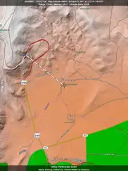
What is scenic map western usa app? A 3D topo map of the Western USA and Hawaii. The vector map data is contained within the app and can be used without an internet connection. Use it in a car, a boat, a plane or while hiking. It is like having more than a third of the country in your pocket.
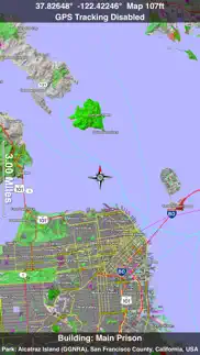
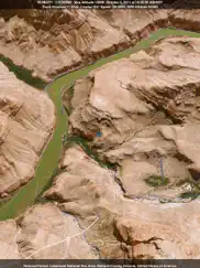
Scenic Map now covers the entire world via online maps. The maps are cached automatically so they can still be used when there is no cell coverage. Turn on Online Map in the Settings menu and you can then scroll or go to any location on the planet. Satellite image overlays add breathtaking detail and realism to the maps (tap preset 2 or 4 when Online Map is enabled). You can use them as you travel to see what is hidden from view at ground level. This takes moving maps to a whole new level.
Use the two finger vertical swipe gesture to tilt the map for a 3D view. Scroll like a map or fly like a flight simulator. Enable Joystick Gestures in the Settings menu and then fly around the terrain using a virtual joystick. Prefer only 2D maps? Enable the 2D Map option in the Settings menu.
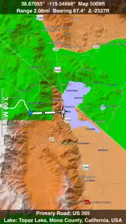
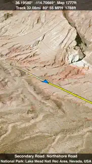
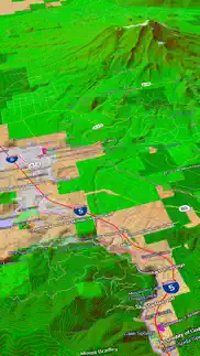
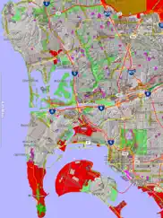
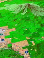
Scenic Map is simply the best 3D topo map available for a mobile device. You will see incredible detail while scrolling, rotating and zooming perfectly smoothly. You will see every road even if you zoom out to the altitude of a satellite. As you zoom in, you will see every small bump and hollow of the Earth and terrain features as small as ten meters. Unlike old fashioned topo maps, Scenic Map’s roads and trails are up to date thanks to OpenStreetMap.org. It contains polygons for urban areas, shopping malls, an ever growing number of buildings and many other features, The best lake, pond, stream and rivers from the USGS and Canadian public databases are also included.
Tap the GPS center button to begin tracking your location. As you move, you will generate a track file. Tracks can be replayed with video like controls to speed up, slow down, pause, restart or skip to the end. You can display existing tracks while recording another if you want to retrace your route. When online, you can automatically create a route from your current GPS location to any other point on the map. Tracks can be received from or sent to other apps in GPX format. GPS recording stops automatically after you have remained stationary for some time or you can choose to manually stop tracking by tapping on the top track in the Tracks view.
Never before have maps been this customizable. For example, you can turn on or off the roads. You can change the lighting direction or remove terrain shading entirely. You can display contour lines even over satellite images. There are five presets which let you quickly switch between map styles. Use Metric, English or Nautical units and choose one of four different coordinate displays including UTM.
Want to learn more about a map feature? Tap the target icon and center the feature under the compass rose to display its name, type, urban area, county, state, elevation and coordinates. You will also see a bearing line back to your current GPS location or from your location to a selected waypoint. The status bar shows the bearing direction and distance along with the map and GPS elevation, the track length, and your current speed and direction of travel.
In-app documentation is provided in the Help section at the top of the Settings menu. Links are provided in the documentation to detailed coverage maps, tutorial videos, installation guide and blog at ScenicMap.com
Map data © OpenStreetMap and contributors under the Open Database License
Scenic Map supports GPS tracking while the app is in the background.
Caution: Continued use of GPS running in the background can dramatically decrease battery life.
😍 Do you love Scenic Map Western USA app? Please share your friends!

Please wait! Scenic Map Western USA app comments loading...
Scenic Map Western USA 1.9.2 Tips, Tricks, Cheats and Rules
What do you think of the Scenic Map Western USA app? Can you share your complaints, experiences, or thoughts about the application with GrangerFX and other users?
Scenic Map Western USA 1.9.2 Apps Screenshots & Images
Scenic Map Western USA iphone, ipad, apple watch and apple tv screenshot images, pictures.
| Language | English |
| Price | $4.99 |
| Adult Rating | 4+ years and older |
| Current Version | 1.9.2 |
| Play Store | com.grangerfx.scenicmapw |
| Compatibility | iOS 16.1 or later |
Scenic Map Western USA (Versiyon 1.9.2) Install & Download
The application Scenic Map Western USA was published in the category Navigation on 01 April 2010, Thursday and was developed by GrangerFX [Developer ID: 363698835]. This program file size is 67.61 MB. This app has been rated by 11 users and has a rating of 4.5 out of 5. Scenic Map Western USA - Navigation app posted on 19 January 2024, Friday current version is 1.9.2 and works well on iOS 16.1 and higher versions. Google Play ID: com.grangerfx.scenicmapw. Languages supported by the app:
EN Download & Install Now!| App Name | Score | Comments | Price |
| Scenic Map Alaska Reviews | 4.5 | 4 | $1.99 |
| Scenic Map Eastern Canada Reviews | 1 | No comment | $3.99 |
| Blue Hound Reviews | 4.6 | 717 | $1.99 |
| Scenic Map Western Canada Reviews | 1 | No comment | $3.99 |
| Scenic Map Central USA Reviews | 4.7 | 4 | $4.99 |
Fast initial download. Maps are then dowloaded automatically. Fixed track recording in iOS 17. Fixed the settings menu in landscape mode on iPhone. Fixed low frame rate when the information bar is enabled. The map's highest detail is now displayed while scrolling.
| App Name | Released |
| Parking.com - Find Parking Now | 07 August 2018 |
| Google Maps | 12 December 2012 |
| EVgo EV Chargers | 17 October 2017 |
| Blink Charging Mobile App | 08 October 2022 |
| Circuit Route Planner | 22 March 2017 |
Find on this site the customer service details of Scenic Map Western USA. Besides contact details, the page also offers a brief overview of the digital toy company.
| App Name | Released |
| Jacksonville Zoo - ZooMap | 25 October 2021 |
| BLM Public Lands Map Guide USA | 27 December 2020 |
| NavRules | 07 March 2011 |
| AyeTides | 06 February 2019 |
| Blitzer.de PRO | 03 August 2022 |
Discover how specific cryptocurrencies work — and get a bit of each crypto to try out for yourself. Coinbase is the easiest place to buy and sell cryptocurrency. Sign up and get started today.
| App Name | Released |
| Target | 24 November 2008 |
| Cash App | 16 October 2013 |
| Spotify - Music and Podcasts | 14 July 2011 |
| PayPal - Send, Shop, Manage | 03 February 2019 |
| Gas | 27 August 2022 |
Looking for comprehensive training in Google Analytics 4? We've compiled the top paid and free GA4 courses available in 2024.
| App Name | Released |
| AutoSleep Track Sleep on Watch | 19 December 2016 |
| Monash FODMAP Diet | 17 December 2012 |
| TV Cast Pro for LG webOS | 23 June 2016 |
| 75 Hard | 19 June 2020 |
| Shadowrocket | 13 April 2015 |
Each capsule is packed with pure, high-potency nootropic nutrients. No pointless additives. Just 100% natural brainpower. Third-party tested and validated by the Clean Label Project.
Adsterra is the most preferred ad network for those looking for an alternative to AdSense. Adsterra is the ideal choice for new sites with low daily traffic. In order to advertise on the site in Adsterra, like other ad networks, a certain traffic limit, domain age, etc. is required. There are no strict rules.
The easy, affordable way to create your professional portfolio website, store, blog & client galleries. No coding needed. Try free now.
Scenic Map Western USA Comments & Reviews 2024
We transfer money over €4 billion every month. We enable individual and business accounts to save 4 million Euros on bank transfer fees. Want to send free money abroad or transfer money abroad for free? Free international money transfer!
I really like it. I love the fact it does not need cell coverage to work. I can be in the middle of no where and have this thing show me my location. Far to many people get into the hills and get lost. Then cant even tell the SAR team their location. This turns my cellphone into a mapping GPS without cell coverage. I love it. But know this app is big. Still loving it! 9 June 2019 I have used it deep canyons and it still works.
Great app. I was looking for an offline map. And the scenic maps are perfect! I don't need an Internet connection. It has helped us get around when we make a wrong turn or need to know if another street intersects. LOVE IT!
Dead in the water!. Cannot update. Would love to, but the update does not recognize that the app is already using sooooo much space, so it won't download the update at all. I tried updating from my Mac without success. Looks like this app is now dead in the water...or on the lost trail!
Missing map of Colorado. I live in Boulder, CO. I bought the Western USA Scenic map to use in Colorado. However, when I try to go to my current location in Boulder, a message pops up saying that I am outside the map boundaries, and that I need a map of Western USA. The map's eastern edge stops near Grand Junction! I reloaded and still have the same problem. I emailed tech support many times and waited for the last 2 months for assistance. Well, tech support is non existent as I never heard back.
Only select area have detail. Low on detail compared to eastern version and other poducts
Misleading description. The description says that this is an atlas "of the entire Western USA". Yet this is not true. You will note in the small print that the eastern edge of this atlas is at longitude W109. Well, my friends, W109 cuts OFF the eastern 99% of BOTH New Mexico and Colorado, the eastern half of Wyoming and the eastern third of Montana. These lands are ALL (in my mind at least!) essential parts of "the entire Western USA". Had I been better up on my longitudes, I would NOT have purchased this app.
Poor implementation. The concept of this App is pretty neat... first of all I'll give kudos to the visual concept. It really is neat! However, what good is a scenic map that does not identify all (or at least most) the roads? To get to some locations you need to have more than the major US and State Highways labeled, this is especially true if there is no 3G data network available, or you're using an iTouch or Ipad that does not have gps. The county roads and more heavily used Forest Service roads need to be identified in order for this app to really shine. If you all you need is a major highway map, this one is over price.
Great app but. I love this app but i will use it more instead of other apps I am using now if they could only make a few changes/improvements: I want to be able to trace my bicycle routes when I get home and save them to my iPad photo, that will make this the best app in the market. Right now I prefer to use another app that I can mark and trace my routes by hand and saved to my photos, post to Facebook or other websites... otherwise the terrain and the ability to navigate is amazing
Love It! Works Great…Must Have when no Cell Service.. Love It! Works Great…Must Have when no Cell Service.
Excellent!!!. Perfect for those areas where AT&T service is non existent. (everywhere in the West)
Essential when out in the backcountry. This app is easily the best I've used of its type. I use it routinely when backcountry skiing and hiking in the western United States. It is my first choice when planning tours and making adjustments on route. The maps are excellent, clear and well detailed and the UI is intuitive. No need to download maps is great. I discovered it also includes Hawaii which was an unexpected pleasure. Everything you want, nothing you don't. 5/5
Finally, just what I wanted. I am an avid hiker and have downloaded just about every app that could display TOPO and Terrain maps that the store had to offer. I have never enjoyed any of the opencycle maps before, but this app really makes them live up to their potential. I have been using this app for a few weeks now and at least here in Idaho, this map is completely accurate (streets are where they should be). The GPS works wonderfully, the maps are detailed and beautiful. I still have to refer back to my delorme TOPO on my UMPC for campsites missing from this package, but 90% of what I need this app serves up. I hope to eventually be able to export waypoints and import GPX tracks, but until then, I will continue to enjoy use of this app. I am about to buy an ipad because of this map app, it's that useful!
Good Deal. I have both this and the Eastern version. See my extended comments there.
New interface nearly ruins a best-of-class app.. I need an always-available, clear and simple flat map where I can see my position and the surrounding streets or terrain. For figuring out where I am and where I should head. I realize that glitzy fly-through POV interfaces appeal to children and developers, but - take it from someone who's been hiking, camping and skiing in wildernesses around the world - They. Are. Not. USEFUL. I don't need another "fly-through" app. I don't need another living room / coffee-shop game. Google Earth is fine for that. At the very least, it should be dead obvious how to turn off the glitz and return to the standard useful map mode. If the first interface a user sees is zooming and twisting all over the place and the user has to look for documentation to figure out how to fix it - and is still stuck with an annoying and pointless sunspot on the map … well, I guess it's time to look for a better app. Maybe MotionX has figured out how to reliably download and store maps by now. I tested several GPS / mapping apps when I got my iPhone 4. Scenic Map was the best for hiking and skiing in the wilderness because of its clear, simple, detailed, accurate presentation of maps and location info on the small screen - with maps always available. I've used it in unfamiliar cities and states for navigation on the road, and on roads far from cell phone access, as well as far from roads and even trails. People ask me what apps were worth paying for, and this is one of two that I always name. Or - named.
Money back please. This is a very poor program. In my area there is a lot of incorrect and missing information, so how can I trust any of it. Names are wrong. Street names are wrong. Street locations are wrong. Streams are in wrong place and are labeled wrong. Campgrounds are shown that don't exist. Major trails in National Parks are not shown. Very poor effort and not worth the money. You are better off with a paper map from AAA.
Great App!. App provides GPS locations with an iPad 3G without having to be within AT&T's coverage area. Works like a standalone GPS since map data is preloaded into the iPad. This features does consume 1.8 G bytes of memory. Do to the large size of the App download into iTunes with a broadband connection. It can then be loaded into your iPad via a USB connection.
A Gazateer In Your Pocket. Let's face it. In a world with Google Earth and satelite-based 3D mapping applications we have all become a bit spoiled when it come to mapping applications. For those of you who can still remember life before Google/Keyhole brought us a 3D spinning globe there used to be paper map books called Gazateers which offered high detail topographic maps for small regions. The scenic map series is the gazateer updated for the 21st century. Because it's all vector based you can zoom in to your heart's content with fantastic detail (gazateer style detail - not road atlas style) and choose what information is overlayed. The coverage area is huge - 1/3rd of the continental U.S. Most importantly it's all resident in your iPhone/iPod - no internet connection required. This is a fantastic product that will mostly be lost on a jaded public. Be advised this product requires about 2GB of space on your device.
Finally, a map app I can use off road. I have tried at least 15 different map apps and this is the first one that I find good enough to depend upon. I do a lot of off-road driving, and more often than not, I am far from cell zones and any ability to dynamically download maps. Scenic Map is requires no prep-work before driving off the grid. It is a completely self contained app and while not perfect, I am rating it a 5 to demonstrate my satisfaction with it relative to other apps I have used. Many of the roads I drive are on BLM land and unmaintained, and the 3D capability of SM is indispensable when I am trying to get myself back to civilization. Additionally, the ability to create Tracks allows me to revisit areas I know passable and in the winter, to navigate in deep snow when the roads are no longer distinguishable from the rest of the terrain. I highly recommend this app.
Spectacular app!. There is a bit of a learning curve, so plan on spending an hour on the developer's web site playing around and figuring out how to use it. Once you get the hang of it, it's a pretty amazing app. Vacationing in Moab, Utah, I was able to get a really good idea of the terrain we were heading in to; the 3D feature lets you travel right up canyons, spin them around, etc. The fact that the app shows local place names, not just the cities, makes it very easy to know exactly where you might be headed. Two thumbs up! One downside is that the app takes a lot of space on your device; that's how it can work without web access. Even after making room on my phone, the App Store told me I didn't have enough space; I had to restart my 4S before I could do the download.
Excellent. Excellent mapping app for all of my off road adventures. Very accurate and detailed.
Very satisfying. I love maps and this product delivers. Visually stunning. I find some of the criticism ridiculous, I don't own 4 WD and don't plan to use this map to navigate on unpaved roads, also I wonder how many suitcases of $10 paper maps would be needed to get all the data contained in this product. In my opinion it is well worth the price.
Quite a feat. Well I haven't yet got my 3G iPad to try this out on the big screen, but I did install it on my iPod touch and this app is nothing short of remarkable. Even on a 2nd generation Touch it's fast, beautiful, and amazingly detailed. On the iPad this is going to be flat-out spectacular. I never thought a map of this complexity could ever be brought to a portable device, but it has been. Superb job!
Best driving map ever!. I have been using this app for the past two years. It has continued to improve with several major updates over that time. I love using it while driving (although it is great for hikes as well and I know that pilots love it). I love seeing the terrain rotating as my car winds its way through mountain roads. It's simply icredible. It is the kind of moving map you would expect to see in the movies, not on the dash board of your own car. Several other users report that they don't like the 3D view in the new version. I also like the 2D view some of the time. That's why the program has presets buttons along the bottom of the screen. I can set one to be the 3D view and another to be a 2D view. A simple swipe gesture can tilt the map to whatever angle I want.. Get the map presets setup how you want before you drive and then you will be able to keep your eyes on the road and just tap the presets to switch views. This is not a navigation style map. Those are great if you want directions from point A to point B. You can run multiple maps at the same time and leave the navigation map running in the background while Scenic Map shows you the terrain ahead. You will still hear the voice prompts for upcomming turns. I prefer to have a separate GPS receiver so my iPad can play audio books in the background. Get this app and you will be wondering why all maps can't look this good? Sure Google maps are great but not when you are out of cellular range or have a low bandwidth. This one app covers a vast portion of the country and never uses any valuable wireless data.
Just too big.. I was trying to load the update but Apple says there is not enough room to load the update. I even deleted the app giving 4.3 GB free and it still won't let me reinstall. A shame as it's a good app.
Impressive App. Beautiful renderings of the topography of the Western US. Very useful for driving with the offline mode, but I do wish it had the ability to import waypoints from Google Maps or a GPX file, for road trip destinations.
Fun. A fun map. The 3d rendering could be helpful. I enjoyed looking at it when hiking today. I was looking for an app that would support importing of gpx waypoints. This does not but the developer assured me that it is coming with the next update.
Crap! Will NOT update.. Would like to try/use this app but it's STUCK on the update and will not load! Worthless and frustrating! Do you even try/use your own app??
Map. I love this app. The only thing missing on it (as well as every other mapping app) is a black background for night driving. The iPad is simply too bright in my car while driving through rural Montana in the dark.
Awesome offline map detail. I've been waiting for something like this and have tried other apps. This is what I've been waiting for. A good solid map app that doesn't need wifi or data coverage. Very nice one too. 1.7GB of data for the western US? I don't care, this is exactly what I want. In addition, I'm a pilot and although there are great aviation apps like Foreflight, ScenicMaps allows me to see more detail about the area I'm flying over.
Great for desolate hiking areas and works using Bad Elf GPS locator. I gotta give this one this 5 stars. We've used this app in hard to reach areas with zero tower signal available on the iPhone 4 and this app works flawlessly with Bad Elf GPS iPhone chip. It's nice to see where you are headed, range in and go. Tracking is a great add on and shows distance traveled, time and elevation. If you need to return to the starting point the app will show you the exact return trail to take you right back. My only complaint would be the map could have a bit more detail. Definitely worth the 10 dollars.. Be sure to spend some time on the website to learn the basics of this app before you head out. The Bad Elf GPS uses the iPhone battery for power so it doesn't hurt to have an added battery pack for the iPhone if you are out on the trail for an extended time.
South West not in western map ?. Are you kidding me!? 90% of Colorado and New Mexico are missing from the Western USA map!! So now I'll have to buy two different maps and spend twice as much just to see what should already be included in this OVER PRICED app? It's hard to navigate and does not work as smoothly as most other map apps. Deleted !
Too Much for the IPD. I like maps. This took forever to download. While interesting, I'd just as soon have a USGS map to look at. After goofing around with it for a couple of hours, I deleted the app.
Unusable - Locked in Update Mode. This used to work OK on my iPad 1. Now it won't work at all, nor can I find a way to cancel the update mode that it's stuck in.
Great little app!. I love this little app. It has already come in very handy when I needed a map and I wasn't near a network. Also, because of this app, I finally figured out the elevation at my house.
Retpd2001. Purchased but it won't install on either my phone or iPad, please fix!
Disappointed. Way to slow rendering maps. Pyrolysis needs work
The best map app. A topo app you can use offline? What more could an outdoorsman want. I only give it 4/5 stars just because no one believes that 5/5 star reviews are authentic. I love this app and use it all the time in the back country where there’s no cell or wifi. Keep up the great work!
An Exceptional set of maps!. While it does take a lot of memory, I have found it well worth it. Since I don't have an IPhone, I just use my Ipad 2 with wifi and a GPS via blue tooth. Now I'm able to save my trips without needing cell phone reception. I now go where I wish and without getting lost! The 3D is so worth it!
Awesome. Really nice for pilots too!. This is a great app. While we use it for flying, it would be great for any sort of traveling. Kinda like G00gle Earth, but doesn't need an live Internet connection. The person who said it was unusable must have got the interface into "joystick mode" by accident. I'm recommending this to all my pilot friends.
hey. I just downloaded the update. 3d is neat, I suppose. However, I like my maps in map view. There is a long tradition of maps in mapview. The problem is the only way to revert to mapview is turn on the sunlight icon. Please get rid of the sunlight icon, it's useless. It interferes with and obscures the map. Afterall, the map infomation is the reason I bought your product. The moment the update comes out with the option to turn off the sunlight icon in mapview. I'll re-review. Also every update that doesn't give me the option to turn off the sunlight option. This review will be reposted to keep it visible on itunes.
PLEASE COMBINE!!. This is a 5 Star App! The graphics are of high quality and being able to zoom in that close blow me away! You have 3 maps of this type. Please combine them into one app. The price you are charging is well worth the quality of work that has went into this app. I understand that the file size of having all 3 combined into 1 would be close to 6 gig, but that is still is better that having 3apps for some of us. Maybe a way to buy the extra maps inside the app we already have? Charge the same price or give a discount, eater / or, still worth the price. BUYERS NOTE: Best topo map as of yet in the app store. A must download, if your into mother earth...
How To Download. There is a How To Download page on the Scenic Map web site. App developers have no control over the app download process but there are simple steps that always solve download problems. Please contact me before writing a negative review. I like to help my customers. -Deneloper
Map Olof the western US. Totally unusable. Navigation is broken. When you try to move the map it just spins in circles. DO NOT BUY!!!!
Nearly worthless app. I bought this for the ability to have the map stored in the iPad 3rd generation while driving the Idaho Bitterroot backcountry on forest roads with no cell coverage. The detail is there but I found it nearly worthless as a practical tool for finding your way around. Map has to be zoomed way in to get the forest roads to show with names/numbers that relate to the small numbered signs you find along the way but when you zoom out to get perspective all the roads disappear. All the default settings seem designed to provide a spinning flyover 3D game type display that may be fun to look at when you are sitting at home but it's worthless when you are sitting at a trail intersection in the woods trying to figure out which way to go. At the very least, there should be a way to STOP the momentum function from flying all over the place and disable all of the silly tilting, sun angles, shadings, seasons, pre-sets, jetc. Way to easy to inadvertently touch the screen in the wrong place or manner and send the map careening out of control or changing to something totally unrecognizable. If your finger lingers a bit too long it goes into "joystick mode" and you're lost, upside down, and off the map again. The free "you need a map" version covers the entire country and will do the job better unless you want the spinning 3D flyover type stuff.
Terrible maps. The maps are virtually useless: 1- the text used is far too large and does more to obstruct the view than it does to help. 2- all the text is oriented horizontally and oversized leaving you to guess at which text goes with which street. 3- The "buildings" shown on the maps are little more than sat view outlines with no reference or naming for parks, malls, etc. 4- The paid versions offer no benefit over the free maps so download the free first, If those serve your purpose, you may be ok with the substantially overpriced paid versions of this app. DISAPPOINTED
Awesome!. This program exceeds in every way, quickly and without Internet needed. Far better than other similar programs I have tried-more than happy!
use it all the time -- its a wonderful help. I use this all the time when hiking and 4-wheeling. The biggest advantage is that the maps are downloaded onto your phone/iPad so you don't need to have an internet connection to see the map -- just a GPS connection to know where you are on it. Lots of detail -- it seems to show almost all dirt roads although very few hiking trails. It's one of my very most favorite apps ..
Do not buy it !. 10$ for this app,rip off,just get paper map from truck stop.Slow,not enough options.
A complete western us map in your pocket. I’ve used this for years to navigate the mountains and canyons of the Western US. It is the most reliable, complete OFFLINE map I’ve found. It’s imaging and shading are very useful for getting a sense of the terrain, vegetation, and even where sunlight is hitting. The limitations are that the dirt road and trail accuracy is decent, but not great. Eg here in Idaho there are old roads that traverse private property or are defunct, still shown here. However, this isn’t alone in that problem, most other maps have the same issue. The good news is that this also includes some roads and trails that the other major maps are missing. The user interface is a bit unusual at first, but once used to it, it is powerful. I always keep a copy of this on my devices, you never know when the zombie apocalypse will knock out the internet (or maybe you just go out of cell range).
Western US starts west of Albuquerque. Seriously the maps are missing half of NM and CO. What a rip now you have to buy central maps to finish off the western US.
Did you know that you can earn 25 USD from our site just by registering? Get $25 for free by joining Payoneer!
Imagine you at your best. All the time. Picture yourself at your sharpest and most productive. Your most alert and focused. Your most lucid, creative and confident. At work. At play. In every area of your life. Add Mind Lab Pro® v4.0 to your daily routine and uncap your true potential. Buy Now!
Its' ok. I find the street names hard to read or follow. No mountain range names ie Mount Rainer and no ferry routes? Hello? Lucky for me I am checking before I go on vacation. I sure hope future updates will improve this app. Otherwise I do not plan to buy any more from this as $10 is a little steep!!
excellent. I travelled to the southwest on a hiking/ camping road trip to two weeks and used this app for city and backcountry navigation. it worked really well. I had no data so everything preloaded was great to have.
Adsterra is the most preferred ad network for those looking for an alternative to AdSense. Adsterra is the ideal choice for new sites with low daily traffic. In order to advertise on the site in Adsterra, like other ad networks, a certain traffic limit, domain age, etc. is required. There are no strict rules. Sign up!
Takes 1GB of memory EACH; MANY street names not accurate/ MISSING. WELL, IT SOUNDED GOOD ! ...so, I bought 3: West, Central, Eastern- before trying to download.... 3 GB ! So, I deleted! Too much memory used and the maps were too slow to adjust between the view settings. Other maps sold ON THE APP STORE offer better accuracy, without taking such memory. I do not recommend. I wasted $30.00. ThIS WAS the worst purchase I've made so far ___for Apps. I incorrectly assumed the pricy would be better...-and the idea of not needing the connection to the internet ... sounded good; the App a memory guzzler however as it turned out. DON'T BUY!
Mostly awesome!😃😃😃👍👍👍. Don't believe the reviews that say this app is junk. The 3d rendering engine is magnificent! It is well worth $10.00 based on that alone. If I were going to make suggestions for improvements they would be: figure out how to make the titles of things float above the landscape so that the text would appear to be flat. Also some sort of data recording such as maximum altitude, maximum speed, a graph of altitude going up and down, that sort of thing would make this app the best thing on the market. I am a professional park ranger with more than 10 years of experience. I have just about every topo map app available. Although data improvements are needed this is clearly one of the most visually stunning renderings of 3-D topo maps ever created for the iPhone. A few more bells and whistles and I would give this five stars without question.😄😄😄👍👍👍👌👌👌