OFFROAD ATLAS App Reviews
OFFROAD ATLAS App Description & Overview
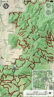
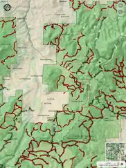
What is offroad atlas app? OFFROAD ATLAS allows you to safely explore our National Forest land, even offline. The app shows your GPS location on our seamless Motor Vehicle Use Map (MVUM) to help you identify roads, stay on trails, obey use classifications, and navigate alternative routes in and out of the forest. We also offer quick access to the official MVUM PDFs.
What is a MVUM? It is a map that shows where you can legally operate a motor vehicle on National Forest land. OFFROAD ATLAS uses your phone’s GPS to show your location on our seamless map. We combine the MVUM with other data such as local roads and our map is easily downloaded for offline use.
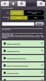
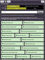
You may browse the map while you have wifi or cell service and OFFROAD ATLAS will automatically download any of the areas you view for offline use when you don't have network access. You may also bulk download any of the areas you plan on visiting.
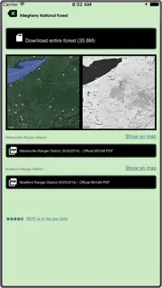
Always have as much information as possible, please consult the published (printable) PDF Motor Vehicle Use Maps available for any individual forests you plan on visiting to get the latest dispersed camping allowances, seasonal closures, and any other relevant information. As always, be careful, many trails and roads are not suitable for passenger car travel. Some are only traversable in the most capable off road vehicles by the most experienced drivers.
Have fun, be safe, and respect the trails.
OFFROAD ATLAS makes no warranty, expressed or implied, including the warranties of merchantability and fitness for a particular purpose, nor assumes any legal liability or responsibility for the accuracy, reliability, completeness or utility of these geospatial data, or for the improper or incorrect use of these geospatial data. These geospatial data and related maps or graphics are not legal documents and are not intended to be used as such. The data and maps may not be used to determine title, ownership, legal descriptions or boundaries, legal jurisdiction, or restrictions that may be in place on either public or private land. Natural hazards may or may not be depicted on the data and maps, and land users should exercise due caution. The data are dynamic and may change over time. The user is responsible to verify the limitations of the geospatial data and to use the data accordingly.
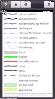
The OFFROAD ATLAS map service depicts Forest Service roads and trails that are designated for motor vehicle use under the official U.S. Government Code of Federal Regulations for identifying designated roads and trails (36 CFR 212.56). Road and Trail MVUM. Additional roads, such as highways, county roads or public roads, are included for mapping purposes. This map service shows the specific types of motorized vehicles allowed on the designated routes and seasonal designation. Data used in this map service are designed to be consistent with the MVUM (Motor Vehicle Use Map). The road and trail data are compiled from the GIS Data Dictionary data and Infra tabular data that the U.S. Forest Service administrative units have prepared for the creation of their MVUMs. This data is published and refreshed on a unit by unit basis as needed and approved by the individual units in order to stay in sync and consistent with the published MVUMs. Interstate, Highway, Other Major Non USFS Roads, and Historic roads for reference are for mapping purposes only and should not be relied upon for their availability for motorized use.
U.S. Geological Survey National Hydrography Dataset, U.S. Department of Transportation Federal Highway Administration HPMS, and various USDA Forest Service datasets used in compiling this information.
😍 Do you love OFFROAD ATLAS app? Please share your friends!

Please wait! OFFROAD ATLAS app comments loading...
OFFROAD ATLAS 1.7.3 Tips, Tricks, Cheats and Rules
What do you think of the OFFROAD ATLAS app? Can you share your complaints, experiences, or thoughts about the application with Michael Keiser and other users?
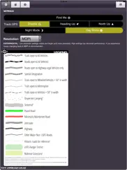
OFFROAD ATLAS 1.7.3 Apps Screenshots & Images
OFFROAD ATLAS iphone, ipad, apple watch and apple tv screenshot images, pictures.
| Language | English |
| Price | $0.99 |
| Adult Rating | 4+ years and older |
| Current Version | 1.7.3 |
| Play Store | ms.dynamic.OffroadAtlas |
| Compatibility | iOS 9.3 or later |
OFFROAD ATLAS (Versiyon 1.7.3) Install & Download
The application OFFROAD ATLAS was published in the category Navigation on 19 May 2016, Thursday and was developed by Michael Keiser [Developer ID: 1114391418]. This program file size is 22.48 MB. This app has been rated by 18 users and has a rating of 1.8 out of 5. OFFROAD ATLAS - Navigation app posted on 18 August 2021, Wednesday current version is 1.7.3 and works well on iOS 9.3 and higher versions. Google Play ID: ms.dynamic.OffroadAtlas. Languages supported by the app:
EN Download & Install Now!| App Name | Score | Comments | Price |
Performance and UX improvements. Various bug fixes. v1.6: More seamless National Forest Motor Vehicle Use Map (MVUM) data coverage showing forest roads and trails for off road/OHV use, satellite imagery, seasonal dates, performance enhancements and a few bug fixes.
| App Name | Released |
| Bonjour RATP | 14 May 2012 |
| Citi Bike | 21 May 2013 |
| EVgo EV Chargers | 17 October 2017 |
| Premium Parking | 22 October 2013 |
| Electrify America | 03 June 2019 |
Find on this site the customer service details of OFFROAD ATLAS. Besides contact details, the page also offers a brief overview of the digital toy company.
| App Name | Released |
| Topo Maps | 26 March 2009 |
| Aprs.fi | 02 December 2015 |
| Solocator - GPS Field Camera | 09 December 2012 |
| Cachly - Geocaching | 11 December 2015 |
| LeadNav GPS | 30 September 2013 |
Discover how specific cryptocurrencies work — and get a bit of each crypto to try out for yourself. Coinbase is the easiest place to buy and sell cryptocurrency. Sign up and get started today.
| App Name | Released |
| Telegram Messenger | 14 August 2013 |
| CapCut - Video Editor | 14 April 2020 |
| Ralph Lauren | 08 November 2021 |
| TikTok | 02 April 2014 |
| YouTube TV | 05 April 2017 |
Looking for comprehensive training in Google Analytics 4? We've compiled the top paid and free GA4 courses available in 2024.
| App Name | Released |
| Paprika Recipe Manager 3 | 15 November 2017 |
| Bloons TD 6 | 14 June 2018 |
| Shadowrocket | 13 April 2015 |
| AutoSleep Track Sleep on Watch | 19 December 2016 |
| TV Cast Pro for LG webOS | 23 June 2016 |
Each capsule is packed with pure, high-potency nootropic nutrients. No pointless additives. Just 100% natural brainpower. Third-party tested and validated by the Clean Label Project.
Adsterra is the most preferred ad network for those looking for an alternative to AdSense. Adsterra is the ideal choice for new sites with low daily traffic. In order to advertise on the site in Adsterra, like other ad networks, a certain traffic limit, domain age, etc. is required. There are no strict rules.
The easy, affordable way to create your professional portfolio website, store, blog & client galleries. No coding needed. Try free now.
OFFROAD ATLAS Comments & Reviews 2024
We transfer money over €4 billion every month. We enable individual and business accounts to save 4 million Euros on bank transfer fees. Want to send free money abroad or transfer money abroad for free? Free international money transfer!
DON’T WASTE YOUR MONEY. I paid for the app and first 2 minutes I hated it. Every time I scrolled the map or zoomed in, I’d have to wait for it to load. EVERY move, no matter how small, it was delayed to load the data. Absolutely worst purchased app I’ve ever purchased. DON’T WASTE YOUR MONEY
Works good WITH cell service. Says you can down load maps for use with out cell service but Map Cache said "download maps will not work till you regain cell service" If that true what good is it back in the mountains with no cell service
Horrible. This is the worst app I’ve seen. I have been scammed out of a dollar. Clunky, laggy, poor quality. Developers just ripping people off.
Weak. Not worth it even being free.
Excellent App! Knew where we were all day long!. We spent 9 hours over two days in a national forest which we’ve never visited before and ALWAYS knew where we were. I could keep track of our progress and made all my turns. We were in a Jeep running roads and trails which were properly labeled to keep us off the atv and utv only trails. I downloaded maps for the forest ahead of time, hooked my iPhone to a Garmin Glo Bluetooth gps, carried the phone in a Ram mount, and ran 12v to both units, not a hiccup all day. Part of the time we had no service too. I was able to investigate the area and trails we wanted ahead of time using the app also. No way I could have the confidence I had using paper maps, this app is worth every penny. Keep up the good work.
Excellent app, download BEFORE you go off-road. People with low rating clearly didn’t download their maps before going into the wilderness. Duh people , you can’t download after you have no reception, download your maps first . Thanks dev for the great app!
Impossible!. This app appears to be designed by a beginner app designer. It is very unusable, and inaccurate. I can't believe I actually paid for it 😡! I don't think the app designer has any interest in improving it, it's been over a year since the last update.
All around good. Great app covers Michigan well, I would like to help the developer update it though cause there are some trails that have closed in my area, I feel like the app could have more goin for it if u cud track your movements through the trails and then share it with other users, and be able to add certain trail information like if there's rocks or obstacles to look for, all in all not a bad app
Don't leave home without it. Knowledge is power- have more fun knowing where you're going and remembering where you've been. This is a great app. Get it, use it, love it. And if you don't love it, the developer is very responsive with troubleshooting issues.
Too Clunky. Kinda useless downloaded the maps and too clunky maps expire
Terrible app. The legend doesn’t match. The lakes are really bad. Found one area I was looking at traveling and there was just a bunch of lakes on the map that don’t even exist. Not a usable application. Wish I could get my money back.
Off road atlas review. This is a useful app in exploring the trails in the parks and forests- much better than the paper maps given by the rangers
Old, broken, zero stars. Old, broken, zero stars
Poor. Even with high speed internet, VERY slow navigation. Only shows a small fraction of the trails.
Great App for serious off-roading and outstanding customer service.. First off. Those giving bad reviews most likely didn't read what the app is intended for and the areas that is covers. I live in Washington state and all of the national forest are available. Furthermore, I had a few questions and Mike went out of his way to help me with making the most of the app. This app ensures that I tread lightly, plan accordingly and stay on roads that I can legally travel.
Incredible!. Not sure what issue 450ex had, but it is awesome to finally have easy access to all the MVUMs. Found many new trails this weekend.
Don't try it. Waste of time and money!
Don’t buy. No better than a typical worthless follow the blue dot maps that come on the phone. Can not find the map that was downloaded according to the app. There is no information on web. I purchased way more than $4 of frustration.
Absolutely worthless. No trail no roads. Interstate and blurred pixelated nothing useful. Not even for .99. Don’t get this it is worthless
Don't waste your money. Don't waste your time or money paid .99 cents for a crap map of the USA no directions.
Junk app. Don't wast a buck
Pass. Not a very good app
Great app!. I’m in Michigan. It’s a great tool in the woods on my dual sport motorcycle.
Not for me..... Couldn't get any trails to come up
Did you know that you can earn 25 USD from our site just by registering? Get $25 for free by joining Payoneer!
Imagine you at your best. All the time. Picture yourself at your sharpest and most productive. Your most alert and focused. Your most lucid, creative and confident. At work. At play. In every area of your life. Add Mind Lab Pro® v4.0 to your daily routine and uncap your true potential. Buy Now!
Adsterra is the most preferred ad network for those looking for an alternative to AdSense. Adsterra is the ideal choice for new sites with low daily traffic. In order to advertise on the site in Adsterra, like other ad networks, a certain traffic limit, domain age, etc. is required. There are no strict rules. Sign up!