Topo Maps App Reviews
Topo Maps App Description & Overview
What is topo maps app? * View over 70,000 Natural Resources Canada 1:50,000 and USGS 1:24,000 topographical maps on your iPhone or iPod touch. * Ideal for hiking and other backcountry activities. * Map downloads are FREE! * More than 16 million maps downloaded so far!
- iPad owners, please see the app "Topo Maps for iPad".
* Users write:
" I've bought all the topo map apps and I like this the best "
" Scans are gorgeous ... the interface is exceptionally clean "
" Downloading maps is easy and fast ... Map displays beautifully and zooms flawlessly "
* Includes Canada (at 1:50,000), the contiguous US (at 1:24,000), Alaska (at 1:24,000 and 1:63,360), Hawaii, Puerto Rico and the U.S. Virgin Islands.
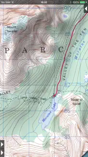
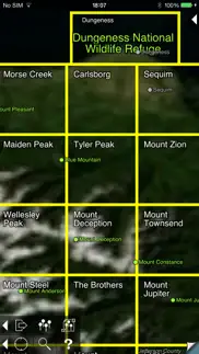
* Locate the maps you need on the satellite view. To install a map, touch for about half a second. Touch again to view it.
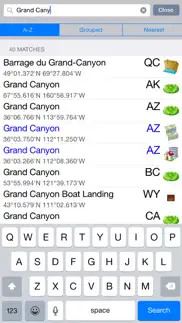
* Search by name for over a million towns, peaks, lakes, parks and other features.
* No network connection is needed once the maps have been installed.
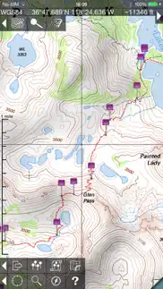
* Mark waypoints, and import and export waypoint files in GPX, KML and CSV formats.
* Touch the "current location" button to see where you are, and the compass button to align the map with the ground.
* See coordinates in NAD27 or WGS84 degrees, degrees minutes and seconds, UTM, or MGRS formats.
* Measure distances (miles, feet and km) and bearings (true and magnetic).
The Maps: This app uses high-quality scans of the traditional USGS and NRCan topographic maps which have been the definitive resource for hikers and other backcountry users for many years. You can make the terrain stand out with hill shading, using simulated sunlight from the direction of your choice. In the U.S., this app does not use the new "US Topo" maps because they do not show hiking trails and lack other details: please see the web site for more details.
Downloading: US maps are around 8 MB in size and download in a few seconds on a typical home broadband connection. Canadian maps are larger. Both cellular data and WiFi can be used, though WiFi is likely to be more reliable in most cases.
- Do please visit https://topomapsapp.com/ for complete instructions, so that you don't miss any features.
We have many ideas for additional features to add to future versions of this app; if you have ideas or other questions or comments, contact details can be found on the website, https://topomapsapp.com/. The website also has more screenshots and other information.
😍 Do you love Topo Maps app? Please share your friends!

Please wait! Topo Maps app comments loading...
Topo Maps 1.19 Tips, Tricks, Cheats and Rules
What do you think of the Topo Maps app? Can you share your complaints, experiences, or thoughts about the application with Mappendix Limited and other users?
Topo Maps 1.19 Apps Screenshots & Images
Topo Maps iphone, ipad, apple watch and apple tv screenshot images, pictures.
| Language | English |
| Price | $7.99 |
| Adult Rating | 17+ years and older |
| Current Version | 1.19 |
| Play Store | org.chezphil.topomaps |
| Compatibility | iOS 13.0 or later |
Topo Maps (Versiyon 1.19) Install & Download
The application Topo Maps was published in the category Navigation on 27 March 2009, Friday and was developed by Mappendix Limited [Developer ID: 298854054]. This program file size is 112.24 MB. This app has been rated by 121 users and has a rating of 4.2 out of 5. Topo Maps - Navigation app posted on 18 April 2023, Tuesday current version is 1.19 and works well on iOS 13.0 and higher versions. Google Play ID: org.chezphil.topomaps. Languages supported by the app:
EN Download & Install Now!| App Name | Score | Comments | Price |
| Topo Maps for iPad Reviews | 4.2 | 14 | $7.99 |
| UK Map Reviews | 3.4 | 5 | $6.99 |
| 3D Map New Zealand Reviews | 1 | No comment | $5.99 |
This is a minor update to fix bugs.
| App Name | Released |
| ParkHouston | 05 May 2017 |
| CapMetro | 31 July 2023 |
| LAZ Parking | 21 December 2018 |
| Parking.com - Find Parking Now | 07 August 2018 |
| Scout GPS Link | 05 August 2015 |
Find on this site the customer service details of Topo Maps. Besides contact details, the page also offers a brief overview of the digital toy company.
| App Name | Released |
| Ski Tracks | 05 April 2010 |
| Cachly - Geocaching | 11 December 2015 |
| AyeTides | 06 February 2019 |
| Spyglass | 04 October 2009 |
| Holding Pattern Trainer | 16 August 2011 |
Discover how specific cryptocurrencies work — and get a bit of each crypto to try out for yourself. Coinbase is the easiest place to buy and sell cryptocurrency. Sign up and get started today.
| App Name | Released |
| Uber - Request a ride | 20 May 2010 |
| PayPal - Send, Shop, Manage | 03 February 2019 |
| Duolingo - Language Lessons | 13 November 2012 |
| Google Drive | 28 June 2012 |
| 28 April 2011 |
Looking for comprehensive training in Google Analytics 4? We've compiled the top paid and free GA4 courses available in 2024.
| App Name | Released |
| Terraria | 28 August 2013 |
| Muse Dash | 14 June 2018 |
| Stardew Valley | 24 October 2018 |
| Bloons TD 6 | 14 June 2018 |
| Purple Place - Classic Games | 17 May 2019 |
Each capsule is packed with pure, high-potency nootropic nutrients. No pointless additives. Just 100% natural brainpower. Third-party tested and validated by the Clean Label Project.
Adsterra is the most preferred ad network for those looking for an alternative to AdSense. Adsterra is the ideal choice for new sites with low daily traffic. In order to advertise on the site in Adsterra, like other ad networks, a certain traffic limit, domain age, etc. is required. There are no strict rules.
The easy, affordable way to create your professional portfolio website, store, blog & client galleries. No coding needed. Try free now.
Topo Maps Comments & Reviews 2024
We transfer money over €4 billion every month. We enable individual and business accounts to save 4 million Euros on bank transfer fees. Want to send free money abroad or transfer money abroad for free? Free international money transfer!
Priceless. This is the best way to get topo maps on your phone in a seamless way. It really works great and I have never had issue with it!
App doesn't download correctly. Will score better when update fixes bug.
Excellent App. This is a wonderful app. Allows to download USGS maps for offline use.
Great app! Very helpful!. Used this app to find the drop in to a canyon in Zion. The maps were quick to download, even when I had bad service, which was great, because I didn't think to download this app until we were driving to the trailhead. It was easy to see where we were and compare it to where we were supposed to be. We made a couple of wrong turns and this app made it super easy to get back on track!
very usable. Good interface -- was confused by other apps but not this one. Download multiple maps at once by dragging over a region. Have used on trails, works very well. Thanks, developers!
Outstanding app. i’ve been using this on backpacking trips for years. It’s fabulous. What could be better than TopoMaps? Thank you for a great product.
Best Topo App!. I've had this app for over five years and it is the best. No subscription fees or in app purchases and it just works.
Bleh. Absolutely not worth $8. It looks like it simply stitched together public Topo maps which you access by clicking on regions overlaid on a google earth map with no local detail . No dot of current location on actual topo map, and the maps are old. It’s telling me I’m at 34’ elevation when I know I am 9 and can literally see the ocean. I need to ask for a refund. This is what you get when you buy without a trial. I do not trust the reviews on this one...
Awesome. This is the best app in the store. I do a ton of camping and use this app constantly to find fire roads and trails. I highly recommend this to any camping or backpacking enthusiast. It would be nice to be able to download multiple maps at once instead of one at a time.
Great App. This is my favorite topo map app. I love its ease of use, and its ability to annotate and pin waypoints. The only thing I don’t care for is that there is no cloud saving of your annotations and waypoints. If it did that it would be the only topo map app I’d use. I use it about two to four times a week when fishing.
This is the topo app for backcountry. I love this app. The map resolution and stitching are excellent. The maps are stored on your phone, so it works way out of data range. Each map is about the size of a standard photo, so you can download hundreds if you want. You see your position on the quad map, and you can drop waypoint pins at your current location or at other points without going there first. The only thing it doesn't do that my old Garmin does, is show your track. The compass link function lets you aim the whole map at a distant object to identify it. You can also switch the map to Google aerial photo of the same area, if you are in data range. I like the old '83 topo quad maps. You see old trails that aren't on newer maps. You wouldn't use this app for driving around town, because a lot of newer roads will be missing, but rarely a problem out in the woods. This app has almost completely replaced my old GPS. The tutorial is nice and clear.
Fantastic. I’ve tried them all (Gaia, OnX, Earthmate, and others) and by far this is the most reliable and intuitive topo application of them all IMO. It has some fantastic features the others do not, and it’s the closest you’ll get to physical topo maps in hand. Sure it doesn’t have all kinds of layers to overlay, but do you want to be caught up in techno-glitter or navigate? Earthmate is lousy, OnX the worst, and Gaia is not bad. Topo Maps+ is pretty good also. This app, however, is always my go to. Kudos to the developer for focusing on simplicity and functionality rather than bling subscriptions that simply bilk you for a lot of crap you don’t need.
Great app. I appreciate the older maps! Lots more info that has been removed off newer maps. Works great. Good job.
Perfect for what you need. I use this app everyday for work. EVERYDAY… Great for someone that spends their days in the woods surveying. -Works offline -Drop pin within feet of your location -Download files to open and use in the field Just the best app
Love this app. The new beta topo maps 2 has zero functionality, so please don’t stop supporting the original.
5Stars, same type maps I carried in army. Same type maps I carried in the army. True topo maps.
Superb App. This app is very simple to use and yet very useful for what we really need in the field. The fact that you can select an entire region (multiple quadrants) for download is worth its weight in gold. In addition, once a region is downloaded, you can load a composite of them with the arrows as you start scanning beyond the loaded quadrant. These are the features I really look for and use most frequently.
Great…Could be magnificent. I like almost everything about this app. Suggested improvement: 1) Allow downloads of satellite imagery in tiles. I have to use other apps for this, but I’d love the option to zoom in and auto switch from Topo to Sat imagery. It’s annoying on other apps you can download imagery, but you never know how much data is being overwritten in the cache memory of the app…so you never know if looking at a new area cause the other area to ‘zero out.’ Downloading tiles would ensure that anything downloaded remains downloaded in only the areas you want. 2) Allow line of sight calculator to add an up to 15% beyond calculation for more realistic propagation of radio waves. The line of sight tool is a fantastic for estimating UHF reception probability while using the direction and distance calculator. If there was a slider to add a yellow color cast to anything 1-15% beyond line of sight, this would assist in estimating UHF/VHF ground wave propagation/refraction fresnel effect of RF energy. 3) Add center point options for your location other than blue dot. All in all, great app…could be even better.
Not intuitive at all. I just bought this app and uploaded a gpx file into it. I can see that the file is in the app with all my waypoints and tracks. But for some reason I can't see the waypoints and tracks on the map. I see no button that indicates how to do so. Nothing. I hate this app and wish I hadn't wasted my money. Total garbage as far as I can tell. I did download GPS Tracks and it works beautifully.
Best app for backpacking, Land Nav, and Survival. This app I amazing. Works without service. It's never been wrong. You should make an Apple Watch version to go with this too for quick compass work, triangulation, and for just a quick look at how far youve gone and have left to go.
Great app!. Definietely worth the $8. An amazingly helpful app. Some complain that the maps themselves are older, I think it's a good thing. Shows features that are no longer shown on modern maps. I'm very glad I purchased.
Worthless. Want a refund. Maps are outdated and worthless. Put in location and map puts me miles away. No tracking features. Worst $8 I have ever been scammed out of. Doesn't look like there is any refund options.
Awesome!. So far, well worth the money. Great maps and easy to use. I've been looking for software to use like this for awhile now and I'm glad I found this. A+
Hunting and Hiking. Used this puppy a ton over the past two years to map hiking routes and to discover great hunting spots. App works flawlessly. Thanks!!
Very disappointed. While this has some nice features, I was very disappointed to learn that it does not support tracking. And the very first screenshot of the app in the appstore shows a map with a TRACK on it!!!! That's very misleading and I want a refund!!!!! From what i can tell, this app has been out for a long time, and the manual says "tracking features are coming soon..." Where are they? The developer hasn't provided an update in almost a year. Even free map apps provide tracking!!
Great functionality, very well done. This is a fantastic app for topo maps. I've used this app for a couple of years and love i. This app has all usgs and canadian government topos. It doesn't provide tracking, profiles, etc, so if you want that look elsewhere, but this is an excellent app for navigation, pins, and topos.
Awesome App and great Developer Support. I’ve used this app for years, it’s a great app for any outdoorsman! I recently upgraded my phone and forgot to export my Waypoints. I did make a backup in iTunes on my computer but my new phone didn’t have enough storage to restore to it. I was able to dig into the backup file though and extract the waypoint file, I then worked with Phil (The Developer of this App) to convert the file to a CSV and re-import the waypoints on my new phone. He was very kind and helpful!
Great but... It would be good to get more features such as "bread crumbs", importing routes and the like. I also had an issue with downloading maps after getting an error due to spotty cell coverage. That did not allow me to download maps even when I had good coverage or wifi afterwords. Still does not work after deleting and reinstalling app :(.
The best. Been using this for years. I love it. I recommend it to everyone. The downloadable maps are so small I can have multiple states available offline on my phone. The gps function works without cellphone service so you can always find where you are. And the waypoints I’ve created over the years are all saved in gpx files so they’re easily transferable when you update your phone. If eight bucks sounds expensive: imagine the cost of buying your entire states topo map collection, then realize you have the entire US/Virgin Islands available to you.
It just works. Great App done right from the start
World Traveler!!. I absolutely love this app! It is seriously the best on the market. I use it for work everyday and would recommend it to anyone. You don’t need cell service once you have downloaded the maps you need. I live abroad and cannot find an app that matches the perfection that this one does. I hope someday soon there will be expansions for the app to include the UK and Europe! Any chance let me know thanks!!
Best app for US topos. I live with topographic maps in the field both for work and recreation and after many years, I still find this the best app for accessing topo maps out there. The interface is clean, downloading maps is quick and fairly straightforward, I can upload text files of waypoints, I can mosaic maps. This app does not chew up battery as some do. The only downside is tied directly to the maps themselves, which are dated as USGS has bailed on true updates, instead turning out substandard GIS-based maps that, while more up to date on roads, are otherwise lacking. So long as the user knows the limits of these maps, there is no problem.
Best Topo App. I’ve used this app weekly since installing it in ‘13. It’s perfect! (Could be more perfect if it were updated for current hardware.) Don’t let this awesome app disappear. Please update it.
Thanks. A very useful app. Thanks for keeping this app updated.
Outdated map. Pulled up the map of the third largest city in MN. The map is decades old. Shows old names of buildings and structures that are not even there anymore. Also fails to show newer buildings and locations
The most useful backcountry tool I have on my phone. This app is fantastic. This is my go to for any backcountry trip- put my phone in airplane mode, use gps on the maps, and the battery will last for days and days. This has made the navigation on so many trips so much easier-from month long mountaineering expeditions to packrafting in remote places to backcountry skiing day trips. Also, the support offered is fantastic. I recently had a problem and got a really fast response from the app creator.
Doesn’t support basic GPX Tracks. I can’t believe I paid $10 for this app. It’s so poorly supported. Why bother with GPX support if you’re only going to support waypoints? Also I got lost once because the app must be closed and re-opened to update one’s GPS location on a map after locking my phone. Otherwise it will tell you that you’re in the same spot until you finally figure out that you’ve been moving while your GPS location hasn’t.
One Problem. Topo maps are so out of date it's really bad. I checked the maps of my area and in 1958 there was no "my area". According to the map I'm out in the wilderness. I'm afraid accuracy is a big problem. The maps are nice to look at but the airport here was moved in 1976 and these maps have it in its old location. About 4 miles in the wrong direction. Too bad I really wanted to like this app.
Most useful app. Just great it works in offline you can set waypoints it shows where there are mines just amazing.
Wilderness backpackers. Used Topo maps on a 5 days wilderness trip. Cell phone was on airplane mode to preserve battery life. The Topo map app let me know exactly where I was every step of the way. Just download all the Topo maps you need ahead of time for free and then you are set.
My favorite app all time. I have owned this app since its launch and can honestly say it is my favorite app period. I am an avid backpacker and hiker and this app has allowed me to find some of the most amazing places in the wild. Maps must be downloaded while you an internet connection, but the gps usually works while out of service so you can locate your position on the topo. I love the ability to link maps together and zoom way in for detail. The map quality is identical to paper topos. I used this app while hiking the John Muir trail and it was great for checking my location and finding off trail lakes and campsites. The search feature works really well so you can find the map you need quickly, download and head out for your adventure. Can't believe this app isn't more popular as it is awesome.
Very Awesome. This app is incredible. Blows all others away! …if you’re a naturalist, hiker, or love being in nature, then get this app. GPS functions very well and the US data from survey is incredible and accurate. I’ve used this app while serving USCG & DHS in Alaska and found it works extremely well while having very little to no listed cellular signal… literally in the middle of the deepest of terrain— I had used this due to the nature of my service for a backup in case I ever faced any emergency situations for basic survival. I’ve had this app since about 2014 and I find it superior.
App freezes up. Never had an issue with this app, after last update it freezes up, won’t open
No updates, disappointing. If I had known this app would not get regular updates I would never have bought it. Both the older maps and lack of tracking is way behind the curve. Look elsewhere.
Excellent Topo map!. Excellent topo map for the price. Extremely easy to use and detailed maps. Please optimize for iPhone X.
poor quality maps. I would save your money. Maps are just scans of usgs topo maps. Scan quality is poor (low resolution), the ones i tested all appeared to be crooked. I uninstalled the app and asked for a refund by never heard back from the vendor.
Best Map App for Outdoors. I love this app. I use this for all my hiking hunting and driving in the mountains. The maps are great detail and have never led me astray
I use it on every hike. So much easier than carrying a sheaf of paper USGS quads! I use this app on nearly every one of our hikes, and love the fact that I can pre-download map data for use in the back country where I often have no cellular service. And I love being able to merge adjacent topos. Somehow I'm always hiking on an edge or at a corner. I just wish for some way to sync the pins/placemarks across multiple devices
The reason I bought a $700 iPad. This is the best app ever made. The cellular enabled iPad mini becomes the ultimate gps enabled, location finding map - even without a cell plan. I use this app to plan backcountry trips, save locations, and save usgs maps for later use for recreation. I also use it extensively to assist my platoon leader with route planning and map recons prior to going on training missions in the Army. This app is what justifies having a GPS enabled iPad for me. Intuitive and easy to use with tons of features and low power consumption. Location finding function can be turned on or off any time within the app to save battery. Adjoining sheets line up as well as when using paper maps and MGRS is supported as well as several other formats. LOVE THIS APP!
BEST TOPO APP FOR LAND SURVEYORS. I use USGS topos daily and this app is really the best way to use these in modern day. No other topo app has real USGS quad maps, and this one having the ability to walk me to within a hundred feet of a section/township/ range corner is amazing. It is especially helpful to download these quad maps for when I go to remote locations. Can’t recommend it enough if you are a surveyor. People complain about the outdated maps but if you want a newer map you shouldn’t be using USGS topos
Did you know that you can earn 25 USD from our site just by registering? Get $25 for free by joining Payoneer!
Only USA. Looks to have good features but only works in the US. Waste of money for me. Should be clear on itunes that is has limited maps so that others don’t get caught
Imagine you at your best. All the time. Picture yourself at your sharpest and most productive. Your most alert and focused. Your most lucid, creative and confident. At work. At play. In every area of your life. Add Mind Lab Pro® v4.0 to your daily routine and uncap your true potential. Buy Now!
Wow!. The best!
Very very bad. At this price, its a rip off!
Works as Prommised. I could see myself using this for work purposes now. It would be nice to have the option to E-Mail the link of the topo map to view from desktop. I would also like to see the blue dot feature to track your movement that is standard in the IPhone Google map app. This would than be ideal for hiking if cell signal is not available. I think this app has good potential. ----------------------------- Update: The more I use this the more impressed I am with the features. I really like the elevation and coordinate feature. I am surprised how accurate this is as you move around the map. I also like that you can change the units and coordinate system just by clicking on it. It would be nice to have the ability to copy the coordinate. How about giving us 3d renderings of the maps in future updates. This would blow our socks off. Thanks for the app.
Topo maps client for Canada (NRCan) and US (USGS) - great start!. This is a well thought-out app with intuitive interface and lots of options. Fills a much-needed niche of on-board topo maps - which are downloaded for free from NRCan (for Canada) via a simple tile interface or via Search, which seems to be pretty comprehensive. Touch-and-hold controls are a nice touch (not intuitive - but help manual is very complete). Now - with a basic topo viewer, the next step is to provide an ability to save waypoints, record a trek (start, pause, save), share a trek (out to GoogleMaps/Earth via kml), view elevation profile of a trek, measure distances, etc etc.. (this is where the 5th star would come from). Great start with new features to follow hopefully! Defintely worth the modest price - Check this app out - Drew
Exactly what I've been looking for.. Finally a super simple gps app with offline maps. All the topos for Canada and US, downloadable in advance for when you don't have a signal. Love that it's simple a scan of the old paper topos I know and love but with a pin for my position and oriented with the compass. It's all I need or want when I'm in the backcountry. Maps are super easy to find and download, unlike other apps with supposed offline capability. I've seen complaints about the age of the Canadian maps and I agree, but those are the most recent government maps available; not great for cities but no big deal in the bush.
Really???. You are better of with google earth and mapquest. Really....that's all this program is.
Citizen. I read many reviews here are my comments for Canada a topo map sells for $16 so this is worth the money. Out of date yes but the majority of topo maps are very old. Make sure you have. Wifi maps are very large. Overall I am having fun for the price cheers
Amazing for canoeing. This has saved me $500 and counting worth of topo maps. The more I learn how to better use it, the better it gets. Just take screen shots with your phone, save them as google docs and then print them, they are absolutely amazing, easy to access and cheap. Very happy with this app.
Just scans of old maps. As the title says its scans of old and sometimes outdated paper maps. Not a very good user interface either. There are better apps that don't rely on scans.
. horrible application the map are not up to date and are simply paper maps. YOU HEARD ME! No sattalite or hybrid! No CaNaDa MAPS!!! Good if free but it's not. Waste of money.
Great product!!. Highly recommend
Bad. Not accurate showing another location then were you are. Nothing line up. Not worth the money. Better free maps.
Horrible maps. Canadian maps are horrible. Nothing compare to the maps on the government website. Save your money!!
To the misguided reviewers:. This is a great piece of ingenuity any way you look at it. It's not their fault the gov't of Canada still relies on 30 year old topos to supply public demand. Realize that they scanned those paper maps and synched them to your fricken telephone!!!!! What have YOU accomplished other than grammatically and factually incorrect app reviews. Keep up the good work. And keep the updates coming. Some great suggestions here.
Great app. Love this app. Great price. Very easy to use. Love the waypoints. But would love a track to show where I travelled
Do not buy. As if I payed for this app. Does not zoom in and will not show the entire map. It's a photo of a topo map I want my money back
Not great. Good idea to have topo maps handy in the palm of your hand. However the maps are so outdated they are almost useless around urban area. I could onLy get coordinates in lat and long no utm. They mean well but have a lot of improvement to make.
Very good. I've been using Topo for off-road for 2 years. This GPS app + common sense, keep me well informed.
No MGRS. Looks great.... But do not waste your money like i did if u want MGRS. you can input the grids, but it only gives u long & lats. Useless to me. Waste of $7.99. Id give it 5 stars if it gave u MGRS...
Awesome. Free topo maps of Canada super duper stuff
Topo maps Canada. I like this app but for the price I would like to see a few things added First off the located is to big and blocks out everything else Second I cannot ad waypoints or mark my path, or find a certain destination. Please upgrade to allow for this. And this will be the best and most useful app I know
I was hoping someone would add this. Now I can find my way when I'm out of cell range :) This app works great! I hope they add the option to add waypoints and tracks.
Changes. The program works good via GPS even without cell coverage, quick and easy to understand, I like the option for low or high resolution map scaling. Just remember to upgrade the scale of map you need before leaving cellular coverage. Great elevation, and point of reference option, the only thing I would add would be the ability to have cookie trails that could be turned on and off as required. If cookie trails were on while not plugged into a DC source It would drain the phone battery, but turned on while driving off the beaten track roads would be of value. I use another navigation program for my boat, which does track your path, so it i would think trails should be relatively easy to add as long as you can turn it on or off. All in all I would defiantly recommend this app and have done so numerous times. I've used it extensively while hunting and hiking and have found it useful. Regards, Ian
Good app. Cdn maps work
Perfect!. Great stuff!!! thanks! I wish I could find the exact same thing with marine maps
Simply awesome. I have been a map junkie all my life and now I have a huge collection of maps from the BC Coasts mountains with me at all times!
Great app. Well thought app
Great. Great canada and us maps. A bit outdated but mountains don't move. Need new map service with logging roads!
Good application, but needs to be improved. The best advantage of the application is the price, which is quite competitive. Maps are easy to load and view, although each high definition map takes almost 50M memory (simple paper scans), so the available memory should be considered. I have rated the application as 3 stars instead of the 5 because of the following functionality must be a part of any topographical application (at least from my point of view): 1. Real time GPS tracking. To find the current position on the map a user has to touch a small "button" on the screen. How I suppose to track my real time movement on 4X4, ATV, bike, etc.? There should be a way to lock GPS tracking so it would refresh the current position automatically (I believe it's not a hard thing to add though). 2. Dropping a pin with description (like camp, waypoint etc.). In case if you found a place which you would like to visit again - you should be able to store the location. Ability to add pictures to the stored locations could be a very nice feature too (after all, iPhone has a camera). 3. Storing tracks. That was a bit surprising a topo map application does not have this functionality. 4. I think the user interface could be neater too. The most annoying thing is the thick blue crosshair of the current GPS position - it is so huge that it even does not fit the screen when you zoom to the maximum level of details. Although the crosshair is partially transparent, I believe the application will look much better with some small and nice 3D pointer which would not grow or shrink when you zoom the map. I hope the mentioned functionality would be included in one of the next versions, and then I would definitely give the app the highest rating.
Old Topo Maps. Download the app and proceeded to download too maps. Installed too maps. Looked at top maps and they were old. Not worth even looking at them since some were so old that highways built in the 70’s weren’t on them. Big waste of time.
Excellent APP. Very happy with this topo app. Does what it is supposed to. Never crashes. Very reliable.
cartes Topo accessibles. excellente application, facile d'utilisation et à un prix très très raisonnable. A quand les cartes de l'Europe?
Bubbly bob. Maps are way out of date . We're talking at least 30 years. No joke! Lots of room for improvment. Now if they could acquire "BackWoods Canada" maps then we'd see the thousands of miles of logging roads that are out there. Nice for having some kind of map handy, but my Garmin GPS blows this away and I loaded my up-to-date topoCanada maps in it also. This app is "OK" just for play but I don't play around in the bush when your life may depends on it. I hope they actually begin to get serious with this app. There's a lot of possibilities to take advantage of in the future of maps and GPS. So far this app looks like it's been quickly pieced together for a quick buck. Now let's get on with some serious updates. We only got .99 worth of our $7.99 investment so far. Time will tell. On my Bubble scale I say 3 bubbles out of ten.
Great. This app is quite impressive. It gives you access topo maps of all North America. That makes it extremely good value. I had a customer support question which was answered almost immediately. I'm not aware of another topo map app for Canada.
Outstanding!!. If you work or play in the outdoors and require a map look no further, you have found what you are looking for. I was searching for Topographical maps with MGRS capability and I found this app, was a bit hesitant at first but boy am I ever glad I purchased this app. If you ever had to first of all try to track down all these maps you know how hard that is got it MNR may have some but having this collection of maps in one spot wow, then protect them with map tac and expect them to last in our weather you know what I am talking about. As for price of app well I say this go and buy a map book at a gas station and tell me the price u are paying. Once I downloaded the app it also came with a few extra features like adding waypoints, visibility ability from your position, satellite view etc. I am very happy with my purchase and will continue to use this app for many years to come no matter where I am deployed. A few hints, download the maps on your wifi network before you head out, yes you can download on your cell network but it uses a lot of your data. Little hard on your battery if you are using location feature as you are traveling in a vehicle but expected no different from any other app that uses your location. Finally if I had one other option I would like to have the ability to link the waypoints together to build a route but really that's a nice to have, the app for now does exactly what I need it to do. Thanks to the creator.
The best for outdoor enthusiast. Most accurate topo map in the App Store. Yeah, the civil side is out of date, but that's what google maps is for. If you don't plan on leaving the city don't get this app. If you want detailed topo information you should get it! It has more information than my Garmin topo software and cost 90% less. With this app, an iPad, and a Garmin GLO GPS receiver, you have every topo map in North America, with your exact location at your finger tips.
iPod issue with Bad Elf GPS 1000. Be aware, Bad Elf GPS 1000 won't work on a IPod touch 4th generation when using Topo maps. Topo maps doesn't use it at all... Deceiving!
Outdated maps. Maps offered for Canada are over 10 years old. Lots of roads missing.
Nice maps.. To bad they are from the 70s
Great Maps. Great detailed maps and features. Works great on the ipad but gps accuracy on the iphone is terrible. Over a kilometer away from my real position but the ipad accuracy is dead on
Great tool. Awesome application, a must have for any backwoods buff. However, maps are not up to date for Canada - for the areas I've downloaded already. There are more recent paper editions. UPDATE: obtain and add the Adventure Maps by chrismar and i'll gladly pay 400% more than current price. This just needs trail markings.
Topo Map. Best value for money of any iPhone app I have ever tried! Outstanding.
Adsterra is the most preferred ad network for those looking for an alternative to AdSense. Adsterra is the ideal choice for new sites with low daily traffic. In order to advertise on the site in Adsterra, like other ad networks, a certain traffic limit, domain age, etc. is required. There are no strict rules. Sign up!
Incredibly useful!. This app is amazing. I'm a big hiker and skiier, and into spontaneity. Now, everywhere I go, I can just download the map on the drive there, and I'm prepared! The app uses GPS to place you on the map too, which works just fine virtually everywhere, far from cell reception is fine. Sometimes the GPS placement is only accurate to within +- 155 ft--usually fine, except when I got off trail recently. I've found this app to be incredibly useful, and well worth the price. I've probably saved $100 in maps in the last 6 months!
Pretty good but could be better. All in all, I like the quality of the scans, and the ease with which maps can be downloaded. A few suggestions to make it better: 1. keep the size of the "current location bullseye" the same regardless of zoom level. When you zoom in max it's stupid big. 2. lose the borders on the topomaps. We don't need the legends (or give the option to have them). I think it'd be better to seam the maps together (as most GPS topo overlays are). 3. Make it smart enough to go to the map you're on. Rather than provide the pretty lame "you're not on the map" dialog, just pick the map you're coordinates say you're on, and load it. 4. I'd love the ability to zoom in even more than we can now. 5. Live tracking would be great, eliminating the need to constantly update position. That's all. Keep working on it; could become the best yet.
Tested in the field. Have now used this app on two survey projects around the Grand Canyon. Worked flawlessly. Allowed us to easily get to our survey start and end points, track progress during transects, help visual landscape etc. Was able to upload waypoints with a bit of work. Other crew used a Trimble, I used this app. Certainly does not replace a high end GPS, but very useful and a great price. Wish you could change universal datum, and upload documentation could be better, otherwise top notch. Buy it!
Invaluable. Best app for adventures. Great customer service. Thank you!
Jaw dropping. I'm amazed at how much this app can do! The more I play with it, the more I discover. In 3 days it has become my all time favorite app. I haven't used it in the back country yet, but I did use it on an urban bicycle adventure yesterday, and it worked flawlessly. I'm still a bit reluctant to use my iPhone as a backcountry gps, but if reception is comprable, and with this app, I may be selling my Garmin. The maps are immaculate when zoomed in. Downloads are quick with wifi ( I still can't believe the downloads are free), and I think I peed myself a little when I found that you can attach adjoining maps SEEMLESSLY! Many thanks to the designer!
Solid, Simple, Effective. My girlfriend wanted a GPS unit for when we go hiking so I got the Bad Elf GPS plugin module and the Topo Maps App for her iPod Touch. I've never used a GPS unit before and was surprised with the accuracy and ease of use. I've had no problems with the unit or the software. I was really impressed with the sharp details of the downloaded USGS maps and love being able to carry a dozen maps in my pocket. I've used all the capabilities of Topo Maps except downloading maps to my computer and its been rock solid, easy to learn and use, and completely effective for what we use it for. Wish all the apps I've downloaded onto my girlfriend's iPod Touch was as good as this one. I never hesitate in recommending Topo Maps to my fellow hikers.
Vitally impressive app!!!. Wow what a great app! Immediately useful right out-of-the-box. Worth every penny! I plan on using this to record my great hunting locations on my property. I've been using topo maps for 40 years this is just totally mind blowing. This app totally proves how smart a smart phone can be. I'm a nuisance wildlife control operator and I can't wait to use this in the field to record trap locations. Don't worry a bad review because of old maps. They obviously are not experienced with topographical maps and how they are updated. If you use topo maps or they would be helpful in your work, you absolutely can't do without this app. Good job gentlemen, very well done application. The Mosaic option gave me goosebumps. I'm using an iPhone 4S with iOS 5.1.1
Way to Go Developers!. This is a well thought-out, intuitive / easy to use application. All the corners have been rounded for a great user interface and an overall great feel. Not only does the App fulfill the general purpose, it adds great features such as one that shows line-of-sight from any location, it also shows distances from anywhere on the map to another (as the bird flies). From the beginning topo-user to the advanced, this App is a MUST. Great Job Phil Endecott, please keep the updates and great ideas coming! A few years ago I paid $50 for a computer application that doesn't hold a candle to this.
Topo. I have had this app 4-5the years now and use it all the time while on the Jeep trails and hiking. This is by far the best GPS👍🏼
Topo Maps v1.4: excellent pocket replacement for Green Trails maps. Exactly like purchasing Green Trails maps, minus the trip to REI and cash outlay for each map. Decide to head out for a hike early in the morning and don't have a map? No problem. Simply scroll to your region of the country, zoom in and you'll see named map squares just like the back of a Green Trails map. Touch the desired map, download and install to your map cache (visit app's website for very simple instructions). Downloads are very fast if you enable your home's wireless broadband connection (3g noticeably slower). 5 minutes later you're out the door with very nice map(s). If your simply looking for readable pocket topos, this is it. Comparing Topo Maps to TopoPointUSA (unfortunately purchased first) is much like HD vs. analog in terms of view-ability. See my review of TopoPointUSA for criticism of that app.
Phenomenal !!!!. To those who say that the map data is a old, you have to understand that this app uses USGS data maps, and is only as current as those maps, it is a fantastic app. There is an easy workaround for maps that Havel data, once you open the topple map, it will let you convert that map to satellite based terrain, or Google maps, orOpenStreetMap. So like anyone ought to, before you head into the backcountry you should always check your maps against current data, this app gives you all the tools to do just that. The ability to "stitch" maps together is a great asset. No more do you get to the edge of one map and have to find your location on the next one, just stitch the next map to your map and the data flows seamlessly. Download times on Wi-Fi are only a few seconds per map. It will even "shade" the maps which turns them into a visual terrain identifying tool. I'm taking this tool into a nine day trip in the Allagash in Maine in September. I will report more on how well it works afterwards. Get this app, learn to use it, you will not be disappointed.
Really Nice. This really nice app works great. So thrilled to be able to see how much farther the end of the trail is, where we are, etc. The downloading of each map is a tiny bit cumbersome. Would be great if you could mark several at once and then start the download. Route support is the only feature I miss, but for hiking isn't that big of a deal. I was very happy to be able to create my route and waypoints in my cumbersome but workable TOPO! software and then download the waypoints to the app. The app is what I had envisioned when I bought a GPS device for hiking several years ago, but the technology then just didn't warrant the expense. This app is well worth the $. Wish the developer would re-write the National Geographic TOPO! software.
Almost perfect NO SUBSCRIPTION Topo app. I have used this app for years, iPhone 4 days. I wish the developer would update the maps but even as it is it is far more useful than most. It seems like it’s been abandoned which is sad. But it’s still worth it, You pay ONCE and have access to download Topo maps of the entire U.S. for as long as you want. All on your phone so no data connection needed. All is not roses though. - alignment is seriously bad in some places. Laughably so. Central Washington state has maps so far out of alignment that adjoing maps look like cards tossed randomly on a table. I have paper USGS Topo maps of the exact same sections and those align perfectly. My National Geographic Topo maps of the same area align perfectly as does my Gaia GPS app. Not sure why these are so badly out of whack. Seems to happen somewhere in areas of various different states i have downloaded maps for -there needs to be a GPS tracking feature. So the app lays down a trail that follows your progress and the tracks can be saved and recalled. The app is really lacking in usefulness without that feature. I am still having to use Topo! Which has this feature so I can save tracks of my adventures. I would love to not have to use Topo! anymore though because it was built for windows 95/XP and that ship has long since sailed. -this isn’t 2000 anymore so the 36 map or whatever limitation that exists when downloading hi-res versions of maps should be removed. These maps are small and downloading even an entire state would be very manageable on todays fast WiFi connections. - need to be able to import GPX files -
Fantastic app. Believe it or not, this is my very first app review despite being a long time iPhone user. This app is so useful I felt I had to leave a comment. I am a local hiker and weekend car camper who always likes to "see" the lay of the land using USGS Quads. I love the resolution and feel of the "old" paper topo maps and this app captures it perfectly. Not only can you view the quads, you can view them in different orientations, set and store waypoints, adjust the relief appearance, see radius scales, and more. This app is a dream in the field. I'm also a geologist, so I use this app on the job too! Awesome app!
Will not refund your money. I’m not a fan of the set up. They will NOT refund your money if you don’t like it.
Thanks. But NOW I need to get a solar recharger for my iPhone. :-) After reading almost every word of ALL the user guide and web pages there is only one issue I've seen. When down loading a map, the app defaults to look at your server and if a download fails from there we have to try time and time again (so far 3G download times are very reasonable). But isn't there a way where users could select the option to continue to wait for your server map(s). Which include the data files and install quickly. Or maybe (if we're in a rip) we could opt to download the files directly from the USGS site?? Otherwise, this app is not only the most expensive app I've ever downloaded. But it's also worth it. Very good quality interface.
Simple UI and easy to understand. Review for 1.13 (3 stars): Please fix all the scrolling on 6+. Panning the map now glitches and jumps to random points on the map. This problem did not exist in 1.12. I contacted Phil and he is working on a fix. iOS8 screwed things up. Review for 1.12 (5 stars): Talk about a simple and easy to use app. Just make sure your device has a lot of space if you want to load up a lot of topo maps. If you have a 16 gig iSomething you won't be able to load up a lot of maps unless you pull down the low res maps and who wants to do that. I pulled down most of NY state and parts of 2 other states and I'm already eating 4.5 gigs as of this review. You do have the option to delete or downgrade maps. I'm not a fan that I can't launch or specify that I want to launch Google Maps if I have it but it's not a show stopper. I'm limited to Apple maps and a few others. A future where I can chose Google Maps would make this app perfect. I can overlook some of the internal pages that feature early '90s UI buttons and such because the main interface is clean and looks good.
A truly 5 star app. Having just returned from paddling Congaree National Park and purchased a standard 24K topo for nearly $15, I was pleased to find such a fine app with the detail needed and the ease of use. Even Garmin does not have the 24K topos for most of the eastern 1/3 of the US yet, but for outdoors types this apps will save hundreds of dollars, particularly when you are only going to need a small section or corner of a topo and you really don't want to have to purchase the whole thing. I can see this app evolving and improving but even if it doesn't, it ranks as one of the very best and most useful apps for hikers and paddlers. Now to make a waterproof iPhone...
No Longer Works At All. When I got my IPhone 14 this quit working. I deleted it, reinstalled it, and it was even worse. Don’t waste your time
Excellent Start - definitely worh the money. I'm glad I bought this program. As it stands the cost may be a little high based on functionality, but I don't think so when you consider the cost of downloading topo maps. There's great potential for this program. Things I would love to see get fixed are better resolution when zooming in so you can see which topo you're looking for and rounding out the compliment of maps to include Alaska and Hawaii. (The last item is somewhat unimportant to me, at least to start but, the maps do need to cover all states.) I suspect that speed and ease of selecting maps would be improved by using a standard type of map. It takes longer to load and drill down in a topo map. Plus what you want to see is where the nearest locations are when you're finding a map. I'm hoping that the developers will add GPS tracking at some point in time. I debated over rating it 3 or 4 stars, but I don't think it would be fair to rate this program 3 stars since it's the first release and topos are expensive. If they do improve this program as I've outlined, this would be an awesome package! So for now, if you need to be able to grab a topo map now and again just to look it over, you can't beat the price. And by buying, hopefully we'll see some great improvements over time!
IOS 16.2 issues. I am having the same trouble as others. I can’t open the app. Is there a bug fix yet?
Eureka!!!. I've been in real estate over 30 years. USGS quads have always been one of the references I use on a regular basis. When they became available online for use on computers, I thought it couldn't get much better. Then, when I could access quads in the field using a laptop I thought"Fantastic"! I never imagined it could become this convenient and easy to use in the field over my phone. I love the fact that I can download a high resolution quad to my iPhone and it's then available for use even if I'm working in a poor-signal or no-signal area. This app has many features and is worth every penny! OUTSTANDING!
Just another user. Excellent app!
No good. Asia Cover Map Don’t Spoort
Best app but issue with new IOS or iPhone 5. discovered to start topo maps in safe mode and again download your maps. I have used this app exclusively for four years. I spend a lot of time in the wilderness and rate this app almost as important as matches. Note this app does not need a cell phone signal just a satellite. Anyway with my new iPhone 5 I couldn't get the app to work. It kept crashing. Disappointingly I sent a email to developer for help and never got any response. Whatever. But after reading the newer reviews I discovered to start topo maps in safe mode and again download your maps. Note all my way points still exist and all is good Thank you for the help in you review.
Solid and useful. Never crashes. Downloads maps well. Stitches maps together seamlessly for the most part. GPS finds my exact location on the map even when I have no cell signal (since it uses GPS which is not reliant on cell signals). When I'm in the backcountry I switch my phone to airplane mode and still pick up GPS. I've used this across the west and into Alaska on some interesting trips and it has helped me out many times to find exactly where I am and where I need to go. I use it on my iPhone and iPad. Used it for years and the value is superb considering all the many maps I've gotten 'for free' from the app.
Outdated maps. Scanned outdated Topo maps. Could have downloaded the PDF current versions of the maps I need, for free.
Great for the money. Now I can have real USGS topos in my pocket when out of cell range, with the blue dot showing current location. USGS topos are not up-to-date, but that is part of what makes them interesting. Installing topos is easy. Either zoom in and click on the quad or search by name. Navigating maps and zooming works as expected, and maps render quickly. Would be nice to smoothly move to adjacent maps while viewing. Another idea would be an option to view adjacent maps without quadrangle white space for those times when the trail straddles several topos. I have not tried the other topo apps, but this one works for me.
The best iTouch Topo app I've found. I've bought all the topo map apps and I like this the best. The major difference is the ease of finding and loading maps, which is intuitive and simple. Yes, sometimes maps don't download but waiting an hour or so has always resolved the issue. I'm usually able to load the 5 of 6 maps I need for the weekend within 15 minutes, and pulling down all of Southeastern Utah took only a bit over an hour. I use this app in conjunction with a real GPS and it is easy to find my location on the map using the coords from the GPS. I could spend $300+ on an expensive GPS, but this works and the maps are free. If the maps would seemlessly join at the edges when tracking, without the white borders, this app would get 5 stars from me.
Unbelievable Value - Free Maps!. Topo Maps is so much more than simply a source for reference maps. My personal thanks to developer Phil Endecott for providing a product that keeps our family safe during our frequent off-roading trips in Southern Utah. Once Topo Maps waypoints are pre-planned for each route, our dash mounted iPhone with GPS function then continuously pinpoints our progress on each map and any inadvertent deviations on the intended route. As we travel, adjoining maps then automatically open. Especially helpful here, where we have less populated and complex trail systems where it would be easy to get lost and possibly run out of fuel. The most valuable tool we could have possibly brought along given my admittedly poor sense of direction. Thanks again!
A fantastic app for viewing North American topo maps. Topo Maps does a fantastic job of displaying North American topo maps. It's simple to select maps for downloading, and the installed maps, which are scans of government topo maps, are very clear. The app allows you to zoom in the maps to see fine detail. The developer, who is very responsive to emailed questions and requests, has steadily added useful features, such as hillside shading, the ability to mosaic maps together, handy tools for measuring locations and distances. You can also launch the Google Maps app, Offmaps, and the author's own excellent Panoramascope with the current location in Topo Maps.
Outstanding App!. Excellent app that is simple yet versatile Used hunting recently and was invaluable. Downloaded area maps ahead of time and used in region without cell coverage. Downloads fast and straightforward. Great detail and coverage. Adjacent maps come together seamlessly. Compass feature is great. I updated my position 10-15 times over 4-5 hr hunts and used about 30% of battery power. This app easily met all my needs and functioned far better with more versatility than my Garmin Rino 530 that I had used previously. This app is highly recommended
Only topographic app you need. One of my favorite apps. Used this in April on 2 week Grand Canyon river trip with iPhone. Of course no cell or wifi coverage for that period but GPS works well except in narrowest parts of the canyon. Able to download and link 280 miles of maps together before the trip. Downloaded mile markers and waypoints along river. Very useful in locating geographic points of interest. USGS topo maps can be very detailed but are not updated frequently. I have several other topo navigation apps. This is by far the best and most useful.
My Number One Map App. I have used this app more times than I can count to plan out and explore potential hikes. I have used it on hikes to bushwhack on a heading. I have used it to get an idea of exactly what kind of terrain I was in. For 8 bucks this app is so worth having to me. I recall it being cheaper when I bought it, but that could just be my age working against me. I have planned out routes and exported the KML. I have imported KML, for example all the parking and shelter locations along the AT. I am sure other apps do this, and some apps might have more upto date versions of the topo maps themselves, but this does the job just nicely.
Almost great...... This is for version 1.9. The display of the maps is fantastic, and the software is very easy to use. The main limitation that I was very dissapointed to learn about is the inability to display a route. You can import a route, and then sync to any point on the route, but you can't actually show the route..... I see that this is a frequently requested enhancement so I will be looking forward to that. With that and just a couple of other minor tweaks, this can easily be a 5 star aplication. Other thoughts: There is a 20 tile limit on downloading maps into the system at one time. I live in Colorado and wanted perhaps 20% of the state loaded. This still ends up being a couple of hundred and doing them 20 at a time was tedious. File association for GPX files. You can import them from within the applicaiton but this is a somewhat tedious process. If they were associated to the applicaiton you could move them much more easily via Dropbox or other means. Even a drag and drop from within iTunes would be an improvement. Track up mode would be really nice. I look forward to new versions and giving this application a 5 star rating! Seach should order the list making the closest items appear at the top of the list.
Needs one thing.. Great application. One thing it absolutely needs is the ability to download maps straight from itunes, via my pc, without wifi. I don't have wifi, I'm not getting wifi, and I'm not driving up the road to McD's to download maps. Limiting map downloads to wifi or phone is ridiculous. I downloaded one low res and one hi res map via the phone's internet. Don't waste your time with the low res. Hi res map is very clear and easy to read when fully zoomed in. Well worth the $8, just need to address that one issue.
Fantastic off road app. This is a spectacular app. Beautiful 7.5 minute USGS topo maps in full color with all the precise details. I used it exploring the Owyhee Canyon lands on ATV's last week. This app allowed me to carry the 100+ topo maps needed for the whole area. I could zoom out and see the overall canyon structure. I could then zoom in on our GPS location. This app enabled decision making better than paper maps or my Garmin GPS. The zoom feature made things easier than the paper maps and the iPhone display was better than the Garmin even though they were both loaded with 24,000:1 maps. I have loaded over 140 topo maps. Each download takes about a minute over my home DSL based network. And all told the maps consume about 2gigs on the iPhone. The user interface is clean, simple, and effective.
Not a topogrophy map. Need a refund!!
Very useful.. I am an avid hunter and this program is priceless! The claims about not being able to zoom in far enough is bs. The maps are copies of the real topo maps if you can't zoom in any further it's because that is the extent of the detail on the actual map. The nav features for establishing magnetic azimuth are amazing. I use this program in conjunction with a compass and if it wasn't for limited battery life of your mobile device it would be all you would need to navigate expertly. My only complaint is that you cannot print sections of the map.
Great app. I have been using this app for about two years, and it has been an all around great experience. My downloaded map library has become pretty extensive over time, and it's great to have detailed terrain info on hand no matter if I'm hunting, fishing, hiking, or camping anywhere from the mountain streams and trails of New Hampshire to the marshes and inlets of the NJ coast, and the vast tracts of State game land in PA. No matter where I might plan to be at any particular time, I need only spend a few minutes adding new map territory to my growing library before I leave home, and it's always ready for my use no matter if a cell or wifi signal is present or not. In fact, when in the field, airplane mode is a great battery saver, and does nothing to hinder the usefulness of this app. It's a winner for any outdoor enthusiast, or backyard explorer.
Awesome App - Small Drawbacks. I have used this app several times now while canyoneering onto new canyons I haven't been to. Delivers as stated and have had no issues. Maps are very detailed (high res) and responsive. I see a few complaints about it not being user friendly, but I don't see that at all. Very easy to use. Perhaps that's the difference of a canyoneer and your regular hiker. This app proves itself, some people just like to get spoon fed. I do have two things that would improve this app. Even though I am already giving this app 5 stars. 1. Support for tracks. These would be immensely useful in addition to just waypoints. My workaround for now is to simply add more waypoints along a track I've made on Google Earth, then import as usual. Developer says support for tracks is in the future. 2. Detail of satellite map. I assume this to keep the size of the as small as possible, but it would prove useful and easier to find areas with a more detailed map. Perhaps have an optional download to have greater detail? Superb app in it's class. It has all you need and what this app may(to some) lack in aesthetics, sure does make up with it's function, features, detail, and performance. Far superior than the other 3 popular offline map apps I've tried.
Difficult to use. I purchased this for a backpacking trip in the Grand Canyon. However, it is virtually impossible to find a specific topo map. 1) To select a map, you need to zoom in on the us topographical map you are greeted with when opening pgm. However, when you do, the map is overlaid with tiny yellow topo map quadrangles, while the underlying geographical map becomes fuzzy and out of focus. Impossible to determine where you are. It took me 10 minutes to find the grand canyon, and I'm a cartographic afficionado. 2) If the map you want is unavailable, an error message says so. But there is no way to back out of that screen other than quitting the application. Frustrating. I give it three stars for a great idea. Needs some work tough.
No way..... I went a two day, 15 mile solo backpacking excursion. This program is amazing. It showed my exactly where I was at, I was able to take photos of scenery on the way and I would then put a pin on my topo map to be able to download my pictures to a program like Google Earth and then share those with my friend. I passed by a Scout troop and told the leaders all about this program and how invaluable it is. I definitely recommend this to anyone who is going out in the woods.
What a disappointment. I seriously wish I could get a refund for this.. what a joke.
Love it!. Totally worth the money.
Helpful trail tool - infinitely better than bulk of paper maps. I bought this app a few days ago after looking for (and not finding) one to go with my desktop topo software. After spending $80 last year for one state (!!), this app is quite the bargain. There are a few things it can't replicate (calculate trail mileage, draw vertical profile of trail, etc. - but that's not the purpose of this app), so I'll still use the other for trip planning, but otherwise...: Took the app (and a printout of the topo, just in case) on a bacpacking trip in the Columbia River Gorge (Oregon) this weekend, and never used the paper. Why would I, when the app is so much clearer and zooms in so much better? I really was very pleased - it was smooth to work with, the maps downloaded quickly, and the level of detail when zooming really close in was amazing. My only complaint is that the contiguous maps don't open automatically. I had to follow a trail to the edge of the map I'd opened, then click an arrow (L, R, up, or down) to open the next map, reorient myself, then continue following the trail. I did get used to it, but it's not ideal. Overall, REALLY practical app and loved having it along; thanks! It will be added to my required packing list from here on out.
Extremely useful app. I've used this app for backpacking in the Yosemite back country, on and off trail, for 4 years, plus day hiking in many other areas, and I have found it extremely useful. The maps can be downloaded and used as part of the pre-trip planning, and icons placed on the intended route and for identifying features you might be interested in. Since I am off-trail much of the time, this was useful. The maps are stored on the device, so no WiFi or internet connection is needed. The GPS feature also is quite useful, and accurate as well. The button has 2 settings. If you tap it, it will find you and lock to that location on the map, but if you tap the button once, it allows you to move the map around, but the unique locator icon remains on your location. If you tap it again, it turns the GPS locator off. Unfortunately, one reviewer wasn't aware of this feature and gave the app a bad review. It uses official U.S. Geologic Survey 7.5 minute topographical maps with 40 foot contour intervals. I mention this because one reviewer gave it a bad review because they weren't "topo maps!" Unfortunately, the USGS doesn't update them anymore, and while the terrain may not change much, towns and roads do. For the backpacking I do, on and off trail, this has never been a problem. For me, it's an excellent and very useful app.
I want my money back!!!!. Can’t even simply search an address?!? Refund please!!!!!
Very good, simple app. Okay, if you are looking for something that tells you where to go without thinking about it, it is called a GPS and you should go buy one. If you want to expierence the joy of navagation without all the paper that goes into the typical map, here is a great app for you. With all the new additions, this app makes it so much easier to plot a course and follow it across terrain. Zooms are smooth and easier to read than paper maps because it magnifies the details. Thanks for a great app.
Excellent app for hikers and backpackers. I just returned from a backpacking trip and used this app to assist with navigation and trail finding. The ability to download the topo maps for free from within the app is huge!! The GPS function is great and works in airplane mode. We needed 4 maps for this trip and fortunately adjacent maps can be stitched together. Sometimes some of the printing from the margin will still be visible when maps are stitched but that is a relatively minor complaint. Ignore the reviews that complain about the old maps. The reason for using the 1970s maps is the greater detail and more trails, as explained thoroughly in the app details and on the website. The complaints are mostly from people that didn't read the documentation and probably don't know how to use topo maps anyway. This app is highly recommended