ISailGPS NZ : NZMariner Charts App Reviews
ISailGPS NZ : NZMariner Charts App Description & Overview
What is isailgps nz : nzmariner charts app? Unleash the navigation potential of your iPhone or iPad with SailGPS NZ! Turn your device into a high-performance GPS receiver with LINZ RNC Nautical Charts, even without a cell signal!
Caught in a storm on the water and your chart plotter fails? Don't worry! Download this app now and regain navigation capabilities to safely return to port. Better yet, buy iSailGPS NZ today ensuring you're prepared for any situation, even in areas with no cell service.
iSailGPS NZ has no sign-ups, ads, subscriptions or in-app purchases, making it more affordable, hassle-free & respectful of your privacy.
Unrivaled Features to Enhance Your Journey:
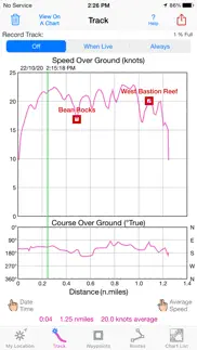
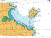
TRACKS, WAYPOINTS & ROUTES
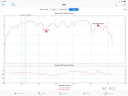
Record tracks as you sail, even in the background. View them on the chart and in a Speed & Course Over Ground graph.
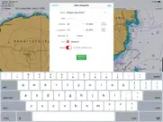
Mark waypoints precisely using charts or satellite maps, place names or addresses, geotagged photos, or by projecting from a known point.
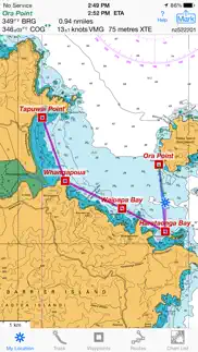
Set a quick GoTo waypoint or a full route and see the course (COG), heading (HDG), bearing (BRG), direction, distance, cross track error (XTE), Velocity Made Good (VMG) and Estimated Time of Arrival (ETA) at your destination and intermediate points. Perfect for racing enthusiasts.
In a Man Overboard (MOB) emergency a single button press marks your current position & starts navigating to it.
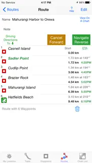
Create customized routes using waypoints, recorded tracks, or imported GPX, KML or TCX files. Advanced route editing.
Send GPX and KML waypoint, route, track and map list files via AirDrop, eMail, Messages or iCloud Drive.
View the sun & moon position, rise times & set times for any date and place on earth.
Send data to other apps such as Google Earth.
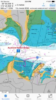
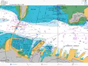
LAND INFORMATION NEW ZEALAND MARINE CHARTS
Access all LINZ NZ Raster Nautical Charts with no extra charge. These charts had their final update on 7/12/23. There will be no further updates.
Our charts are optimized to download faster using WiFi or cell service. Store a few charts or charts for the whole country to use anytime without cell service.
Stitches Mercator charts & automatically switches between downloaded charts as you sail. Choose detailed or overview charts.
Enjoy the high resolution and what's-all-around detail of these NZ Nautical Charts (RNC). They are a welcome advantage over Vector Charts, which only show a coastline, depths, navigation aids, and minimal details.
Print and Share chart images overlaid with waypoints, routes & tracks.
Measure distance between any two points.
USE YOUR PREFERRED UNITS
Kilometers, Miles or Nautical Miles.
Meters or Feet.
Degrees, Degrees/Minutes, Degrees/Minutes/Seconds, UTM or NZTM2000 grid.
°True or °Magnetic.
HOW TOS
Tap Help in the app.
Online Manual: iSailGPS.com/nz
Email developer: lwjames@isailgps.com
RASTER CHARTS vs. VECTOR CHARTS
The Land Information New Zealand Raster Nautical Charts in iSailGPS NZ differ from computer-drawn vector ENC charts in that each chart covers a specific area, the same way a paper nautical chart does. Switches automatically to a new chart when you leave the area covered by the previous chart. For many locations, there are multiple charts at different scales with different levels of detail & areas of coverage.
Paper charts can contain multiple panels, each showing a different area or scale. Each digital panel is individually displayed by iSailGPS NZ with a north-up orientation.
iSail GPS NZ is priced to make it readily available to all boating enthusiasts.
iSailGPS NZ and the charts that it includes do NOT meet the legal requirements for navigation using charts that you may be required to carry.
DEVICE REQUIREMENTS
Use iSailGPS on any iOS device even if you don't have a cellular data plan for it. iPhones & WiFi+cellular iPads support all features. For WiFi-only iPads, an iOS-compatible external GPS receiver is required to show your location & record tracks. You can view charts using the iOS device alone.
Discover a safer and more enjoyable sailing experience with iSailGPS NZ!
😍 Do you love ISailGPS NZ : NZMariner Charts app? Please share your friends!

Please wait! ISailGPS NZ : NZMariner Charts app comments loading...
ISailGPS NZ : NZMariner Charts 9.4.7 Tips, Tricks, Cheats and Rules
What do you think of the ISailGPS NZ : NZMariner Charts app? Can you share your complaints, experiences, or thoughts about the application with James Associates Inc. and other users?
ISailGPS NZ : NZMariner Charts 9.4.7 Apps Screenshots & Images
ISailGPS NZ : NZMariner Charts iphone, ipad, apple watch and apple tv screenshot images, pictures.
| Language | English |
| Price | $1.99 |
| Adult Rating | 4+ years and older |
| Current Version | 9.4.7 |
| Play Store | com.macgpspro.iSailGPS-NZ |
| Compatibility | iOS 12.0 or later |
ISailGPS NZ : NZMariner Charts (Versiyon 9.4.7) Install & Download
The application ISailGPS NZ : NZMariner Charts was published in the category Navigation on 14 September 2014, Sunday and was developed by James Associates Inc. [Developer ID: 351499178]. This program file size is 9.13 MB. This app has been rated by 14 users and has a rating of 1 out of 5. ISailGPS NZ : NZMariner Charts - Navigation app posted on 20 April 2024, Saturday current version is 9.4.7 and works well on iOS 12.0 and higher versions. Google Play ID: com.macgpspro.iSailGPS-NZ. Languages supported by the app:
EN Download & Install Now!| App Name | Score | Comments | Price |
I'm continually improving this app so it will be even more useful! This minor update has updated text in some sections of the Help function. What's new in iSailGPS NZ when compared with other available New Zealand chart apps? You don't just see waypoints and routes displayed on the chart, you can actually do real great circle navigation to those waypoints and along those routes. You get information such as Estimated Time of Arrival, current bearing, heading and cross-track error, and remaining distances to your intermediate and final destinations. You can create, import, edit, export, and navigate both on routes based on a recorded or imported path, and on routes based on a series of waypoints. Get the weather report and forecast, the sun and moon position, rise and set times, and driving directions to the dock for any point on a chart with a few taps. iSailGPS NZ's code size is kept very small by efficient programming so in an emergency, you can download it easily even over a weak cell connection. The current version of iSailGPS NZ runs on the latest devices and also on older devices with older versions of iOS , all the way back to devices such as the iPhone 6. Check the App Privacy section. We don't know who you are when you are using iSailGPS NZ. We never send your current location or your recorded track to our servers. Hence we cannot and don't use your location data. We cannot and don't provide your location data to anyone else. Unlike other mapping apps that profit from using your location data in ways that do not keep it private, iSailGPS NZ maintains the highest level of data confidentially.
| App Name | Released |
| Circuit Route Planner | 22 March 2017 |
| Bonjour RATP | 14 May 2012 |
| Parking.com - Find Parking Now | 07 August 2018 |
| KakaoMap - Korea No.1 Map | 27 February 2009 |
| Footpath Route Planner | 07 May 2013 |
Find on this site the customer service details of ISailGPS NZ : NZMariner Charts. Besides contact details, the page also offers a brief overview of the digital toy company.
| App Name | Released |
| BLM Public Lands Map Guide USA | 27 December 2020 |
| Exit Strategy NYC Subway Map | 07 July 2009 |
| World Tides 2024 | 14 November 2023 |
| AyeTides | 06 February 2019 |
| Speedometer 55 Pro. GPS kit. | 10 June 2012 |
Discover how specific cryptocurrencies work — and get a bit of each crypto to try out for yourself. Coinbase is the easiest place to buy and sell cryptocurrency. Sign up and get started today.
| App Name | Released |
| Messenger | 09 August 2011 |
| TikTok | 02 April 2014 |
| SHEIN - Online Fashion | 19 May 2014 |
| BeReal. Your friends for real. | 08 January 2020 |
| PayPal - Send, Shop, Manage | 03 February 2019 |
Looking for comprehensive training in Google Analytics 4? We've compiled the top paid and free GA4 courses available in 2024.
| App Name | Released |
| Earn to Die 2 | 20 November 2014 |
| Purple Place - Classic Games | 17 May 2019 |
| Bloons TD 6 | 14 June 2018 |
| Bloons TD 5 | 15 November 2012 |
| TV Cast Pro for LG webOS | 23 June 2016 |
Each capsule is packed with pure, high-potency nootropic nutrients. No pointless additives. Just 100% natural brainpower. Third-party tested and validated by the Clean Label Project.
Adsterra is the most preferred ad network for those looking for an alternative to AdSense. Adsterra is the ideal choice for new sites with low daily traffic. In order to advertise on the site in Adsterra, like other ad networks, a certain traffic limit, domain age, etc. is required. There are no strict rules.
The easy, affordable way to create your professional portfolio website, store, blog & client galleries. No coding needed. Try free now.
ISailGPS NZ : NZMariner Charts Comments & Reviews 2024
We transfer money over €4 billion every month. We enable individual and business accounts to save 4 million Euros on bank transfer fees. Want to send free money abroad or transfer money abroad for free? Free international money transfer!
Did you know that you can earn 25 USD from our site just by registering? Get $25 for free by joining Payoneer!