Forester GPS GIS III App Reviews
Forester GPS GIS III App Description & Overview
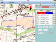
What is forester gps gis iii app? “Forester GPS GIS III” provides tools for estimating basal area per acre for a timber stand as well as GPS data collection and mapping functions for use on the iPad. It will let you use a GPS receiver to map a timber stand or any other land parcel then create grid points over the area. You can also create features by importing feature data in Shapefiles or DXF format, by manual digitization or by entering deed calls. The acreage and perimeter of an area feature will be promptly computed. You can easily divide or combine the land plots. You will be able to record attribute information for each geographic feature. You will also be able to generate a contour map based on an attribute. You will also be able to export the feature data to Shapefiles, Excel files, DXF files and KML files.
If your device has GPS capability, the Point Stakeout function could help you locate the cruise points, and the Line Stakeout function could help you stay on a transect line.
Please note: The accuracy of the location data depends on the GPS receiver used. Continued use of GPS running in the background can dramatically decrease battery life. The app lets you easily toggle the GPS on or off.
Detailed Function List:
* Import and export from/to Shapefiles, Excel files, DXF files and KML files.
* Export to GPX file.
* Import/Export Point Feature data via text file.
* Load a GeoTiff map image for off-line use and for use in Moving Map mode.
* Use GPS to map land features as Points, Lines and Areas.
* Precisely digitize Points, Lines and Areas over the built-in Map.
* Draw a deed plot by entering angles and distances.
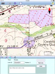
* Classify the Features on a Topic layer.
* Modify the Line and Area Feature shapes by adding or deleting nodes.
* Transform data to commonly used coordinate systems.
* Move existing nodes to fine-tune the map drawing.
* Create grid points over a timber stand to use as sampling points.
* Create a contour map and compute volumes.
* Use the built-in angle gauge for point sampling at each sampling point.
* Automatically record tree tally and BA/acre for each sampling point.
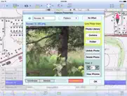
* Attach photos to the Features.
* Enter a formula for computing values derived from other Attribute Values.
* Tag the Features with pre-defined Attribute/Values.
* View position, length and area values for the Features.
* For a Topic layer, go to a Feature, sort the Features, or report statistics.
* Split an Area by using a Split-Line.
* Disconnect a Line Feature or an Area Feature.
* Join Features.
* Create buffer zones around a Line or Area Feature.
* Label the Lines with segment lengths and directions as well as corner angles.
* Label the Areas with size in acres and square feet or hectares and square meters.
* Measure distances and areas on the displayed Map.
* Create a point from the entered address or coordinates.
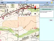
* Create a Point or record a node by picking the GPS location.
* Use GPS to locate and stake out Points or nodes on a Line or Area Feature.
* Use GPS to guide you along a specified Line or Area boundary.
* Save the job data file for later use.
* Output the drawing and the coordinates to PDF.
* Email the job data files and the PDF files to your colleagues.
* iCloud file storage support.
This app comes with a built-in help document.
😍 Do you love Forester GPS GIS III app? Please share your friends!

Please wait! Forester GPS GIS III app comments loading...
Forester GPS GIS III 1.0.6 Tips, Tricks, Cheats and Rules
What do you think of the Forester GPS GIS III app? Can you share your complaints, experiences, or thoughts about the application with CORVALLIS MICROTECHNOLOGY, INC. and other users?
Forester GPS GIS III 1.0.6 Apps Screenshots & Images
Forester GPS GIS III iphone, ipad, apple watch and apple tv screenshot images, pictures.
| Language | English |
| Price | $199.99 |
| Adult Rating | 4+ years and older |
| Current Version | 1.0.6 |
| Play Store | com.CMTINC.Forester3 |
| Compatibility | iOS 11.0 or later |
Forester GPS GIS III (Versiyon 1.0.6) Install & Download
The application Forester GPS GIS III was published in the category Navigation on 07 June 2015, Sunday and was developed by CORVALLIS MICROTECHNOLOGY, INC. [Developer ID: 409254105]. This program file size is 15.43 MB. This app has been rated by 15 users and has a rating of 1 out of 5. Forester GPS GIS III - Navigation app posted on 12 October 2023, Thursday current version is 1.0.6 and works well on iOS 11.0 and higher versions. Google Play ID: com.CMTINC.Forester3. Languages supported by the app:
EN Download & Install Now!| App Name | Score | Comments | Price |
| IGPSGIS II Reviews | 5 | 3 | $44.99 |
| ICMTGIS III Reviews | 1 | No comment | $199.99 |
| Stakeout iCMT Reviews | 2.6 | 5 | $14.99 |
| Forester GPS GIS II Reviews | 5 | 1 | $94.99 |
| Contour - Volume - Stakeout Reviews | 5 | 1 | $29.99 |
Coordinate Information screen update.
| App Name | Released |
| Volta Charging | 11 June 2015 |
| KakaoMap - Korea No.1 Map | 27 February 2009 |
| Neshan Map | 04 May 2023 |
| Bonjour RATP | 14 May 2012 |
| Speedometer Simple | 18 November 2014 |
Find on this site the customer service details of Forester GPS GIS III. Besides contact details, the page also offers a brief overview of the digital toy company.
| App Name | Released |
| Jacksonville Zoo - ZooMap | 25 October 2021 |
| AyeTides | 06 February 2019 |
| Solocator - GPS Field Camera | 09 December 2012 |
| Topo Maps | 26 March 2009 |
| Ship Finder | 01 April 2010 |
Discover how specific cryptocurrencies work — and get a bit of each crypto to try out for yourself. Coinbase is the easiest place to buy and sell cryptocurrency. Sign up and get started today.
| App Name | Released |
| CapCut - Video Editor | 14 April 2020 |
| Telegram Messenger | 14 August 2013 |
| PayPal - Send, Shop, Manage | 03 February 2019 |
| 07 April 2016 | |
| 28 April 2011 |
Looking for comprehensive training in Google Analytics 4? We've compiled the top paid and free GA4 courses available in 2024.
| App Name | Released |
| Paprika Recipe Manager 3 | 15 November 2017 |
| Earn to Die 2 | 20 November 2014 |
| Poppy Playtime Chapter 1 | 08 March 2022 |
| Plague Inc. | 25 May 2012 |
| Terraria | 28 August 2013 |
Each capsule is packed with pure, high-potency nootropic nutrients. No pointless additives. Just 100% natural brainpower. Third-party tested and validated by the Clean Label Project.
Adsterra is the most preferred ad network for those looking for an alternative to AdSense. Adsterra is the ideal choice for new sites with low daily traffic. In order to advertise on the site in Adsterra, like other ad networks, a certain traffic limit, domain age, etc. is required. There are no strict rules.
The easy, affordable way to create your professional portfolio website, store, blog & client galleries. No coding needed. Try free now.
Forester GPS GIS III Comments & Reviews 2024
We transfer money over €4 billion every month. We enable individual and business accounts to save 4 million Euros on bank transfer fees. Want to send free money abroad or transfer money abroad for free? Free international money transfer!
Did you know that you can earn 25 USD from our site just by registering? Get $25 for free by joining Payoneer!