Michigan Offroad Trail Map App Reviews
Michigan Offroad Trail Map App Description & Overview
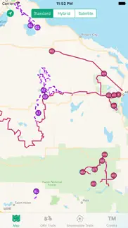
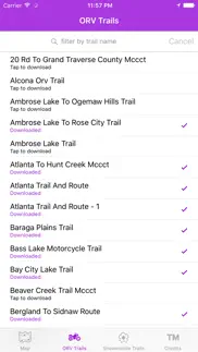
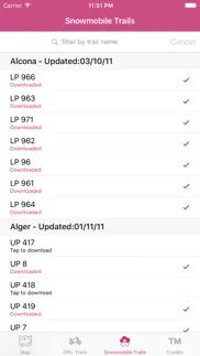
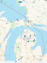
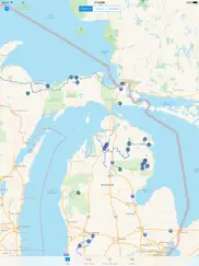
What is michigan offroad trail map app? This application is your guide to the 4x4 and snowmobile trails of Northern Michigan (Lower and Upper Peninsula).
Trail data is stored on the device, so if you are out of cell coverage you can still view the trail locations and your current location (underlying map data may not be rendered without data connection).
Disclaimer: Trail data is from the Michigan DNR and is not guaranteed to be accurate. Some trails are seasonal and lie on private property. I am not responsible for any damage caused or liability incurred while using this application.
If you like the app, leave a review. If you don't like it, still feel free to leave a review, but please try to mention your issue so that I can address it in a future update. Thanks!
😍 Do you love Michigan Offroad Trail Map app? Please share your friends!

Please wait! Michigan Offroad Trail Map app comments loading...
Michigan Offroad Trail Map 4.0 Tips, Tricks, Cheats and Rules
What do you think of the Michigan Offroad Trail Map app? Can you share your complaints, experiences, or thoughts about the application with Brendan Kirchner and other users?
Michigan Offroad Trail Map 4.0 Apps Screenshots & Images
Michigan Offroad Trail Map iphone, ipad, apple watch and apple tv screenshot images, pictures.
| Language | English |
| Price | $2.99 |
| Adult Rating | 4+ years and older |
| Current Version | 4.0 |
| Play Store | com.BrendanKirchner.AtlantaTrails |
| Compatibility | iOS 11.0 or later |
Michigan Offroad Trail Map (Versiyon 4.0) Install & Download
The application Michigan Offroad Trail Map was published in the category Navigation on 21 January 2014, Tuesday and was developed by Brendan Kirchner [Developer ID: 530222876]. This program file size is 10.92 MB. This app has been rated by 35 users and has a rating of 3.0 out of 5. Michigan Offroad Trail Map - Navigation app posted on 19 February 2020, Wednesday current version is 4.0 and works well on iOS 11.0 and higher versions. Google Play ID: com.BrendanKirchner.AtlantaTrails. Languages supported by the app:
EN Download & Install Now!| App Name | Score | Comments | Price |
| ID Validator Reviews | 1 | No comment | $1.99 |
| EZ Contact Share Reviews | 3.8 | 5 | $0.99 |
| Your Civic Duty Reviews | 1 | No comment | Free |
| Brewed In Michigan Reviews | 5 | 3 | Free |
| Brewery Mug Club Reviews | 1 | No comment | $24.99 |
This version should drastically fix some of the "random straight line" issues with the ORV trails. I am working on a similar fix for snowmobile trails. I also improved download times for ORV trails.
| App Name | Released |
| Neshan Map | 04 May 2023 |
| Google Maps | 12 December 2012 |
| Electrify America | 03 June 2019 |
| Footpath Route Planner | 07 May 2013 |
| Citi Bike | 21 May 2013 |
Find on this site the customer service details of Michigan Offroad Trail Map. Besides contact details, the page also offers a brief overview of the digital toy company.
| App Name | Released |
| NavRules | 07 March 2011 |
| Cachly - Geocaching | 11 December 2015 |
| Speedometer 55 Pro. GPS kit. | 10 June 2012 |
| Aprs.fi | 02 December 2015 |
| Ship Finder | 01 April 2010 |
Discover how specific cryptocurrencies work — and get a bit of each crypto to try out for yourself. Coinbase is the easiest place to buy and sell cryptocurrency. Sign up and get started today.
| App Name | Released |
| Hive Social | 18 October 2019 |
| Ralph Lauren | 08 November 2021 |
| 12 February 2019 | |
| WhatsApp Messenger | 03 May 2009 |
| CapCut - Video Editor | 14 April 2020 |
Looking for comprehensive training in Google Analytics 4? We've compiled the top paid and free GA4 courses available in 2024.
| App Name | Released |
| The Wonder Weeks | 30 May 2012 |
| Procreate Pocket | 17 December 2014 |
| Bloons TD 6 | 14 June 2018 |
| HotSchedules | 30 October 2008 |
| Minecraft | 17 November 2011 |
Each capsule is packed with pure, high-potency nootropic nutrients. No pointless additives. Just 100% natural brainpower. Third-party tested and validated by the Clean Label Project.
Adsterra is the most preferred ad network for those looking for an alternative to AdSense. Adsterra is the ideal choice for new sites with low daily traffic. In order to advertise on the site in Adsterra, like other ad networks, a certain traffic limit, domain age, etc. is required. There are no strict rules.
The easy, affordable way to create your professional portfolio website, store, blog & client galleries. No coding needed. Try free now.
Michigan Offroad Trail Map Comments & Reviews 2024
We transfer money over €4 billion every month. We enable individual and business accounts to save 4 million Euros on bank transfer fees. Want to send free money abroad or transfer money abroad for free? Free international money transfer!
Cant tell what can ride what trail. How do you tell what is allowed on what trail?
Seems ok. Having trouble mapping trails
Update app. Could be a very useful app if the issue with all the straight line interference is corrected. Please update app!
Junk. Don't show current location. I have full service. I want a refund the dnr has the same maps to download for free
Great app. This is a really handy app for anyone that rides ORV trails in Michigan! Especially when you ride a new trail. The map was accurate and easy to use. Highly recommended!
This app saved my life!. I was tired of using the online DNR maps coupled with GPD to figure out where I was. So I fortuitously downloaded this app before heading out. On June 16th, about 30 minutes into a remote trail my wife’s “50” trail width” UTV broke down. There was no one in sight to ask for help and we had two small children with us. The tie rod on her UTV was broken and it had rolled over. I looked on this app and noticed I was only 300 yards from a larger ORV trail that I could pull the UTV through the forest with my other ATV and get to civilization. After a few hours and lots of work we all got back to the trailhead safely. Thank you to whoever wrote this program! It may not be perfect but it is very helpful and is worth st least 99 cents. Please note on the maps where the parking and trail heads are located. This is the only missing feature. Again thanks so much.
Straight lines. It’s a great app. I downloaded all of the maps, then it looks like it added extra straight lines that garble everything up. It would be great if those weren’t there.
AWSOME app. I love the app. Works perfectly on all the trails I’ve been on. Love the ability to transfer from standard to Satellite. A+++++
Needs work!. Doesn't show parking areas or gas. Does not show different trail widths. If you are using this to check out new places you will still have to go to mi.orv
Awesome!. The trails aren’t labeled very good when riding but using this app with gps is great because it shows your location on the map. It was well worth the $3 to get around here on the upper Peninsula! When you download it I recommend downloading ALL of the trails the four wheeler and the snowmobile trails you can get anywhere you want the area is covered in trails. We took an atv from paradise the whole way across!
Uh. Where are the rest of the trails?. Downloaded the app for when we’re out riding and don’t have service on our phones. The app is missing so many trails, especially around Clare and Roscommon County. I’m sure the app would work great if you’re in northern Michigan or the Upped Peninsula but for we ride its worthless.
Really!. I thought this would be a good app for out on the trails instead of digging out a map, great idea but your map is a mess . The downloaded trail is shown but covered up by several straight lines, which represent what?cant be roads , they are perfectly straight and go right out into Lake Superior , in the U.P. of Michigan, or county lines , doubt if they are that straight , so what are they and why are they covering the map I paid to see ? I hope there is a fix available or in the works , or I have just wasted .99 cents
Pretty useless unfortunately. It loads way too slow to be of use for general exploring. Cool concept but there are a couple other apps better suited or arc gis which is free and way more detailed
Waste of money. Shows outline of trail. Does not have any names, mile markers, or numbers. Has basic trail. Missing several other trails routes in grayling, west branch, St Helen, and houghton lake area. If lost or turned around this map does nothing to help. It was a waste of money. Doesn't follow you as you drive. No compass or instructions. Very basic and lame.
Rough. App shows routes that don’t exist and shows routes as straight lines when there is important detail. Trail number is not shown when zooming in.
Nicely done trail map!. I had been looking for a good snowmobile trail map app for when I’m snowmobiling in the UP. This app definitely seems to foot the bill. I’ll be using it for the first time next week in the UP. Only wishlist item I have is it’d be really cool if you could search for POI such as gas stations, restaurants, etc.
Needs work. Great idea. Flawed implementation. Straight lines showing trails that don’t exist are confusing. LP6 goes right through Houghton lake! Needs some cleaning up. Many more errors, LP6 is just one example. ORV seems to be better than snowmobile trails though.
No details? A legend?. Am I missing something? How do we know what type of trails we are looking at? Other than MCCT in the name, there seems to be no reason to the names or colors of the icons (that I can quickly determine) Example; North Branch Route or North Branch Route Track. What are they, motorcycle only, orv, side by side? What is a track? That is not verbiage that the DNR uses. I like to ride motorcycle only trails, how do I determine this? Which trails require a motorcycle to have a license plate? Example: Both Horseshoe Lake Trails have a red icon, doesn’t the north loop require a license plate? Or how does a side by side driver determine which trails he can access? I think I purchased this too quickly and, unless I’m just missing the details - which I could be, I don’t think this will be any use to me.
Best MICHIGAN Mobil ORV trail app around!!. This is the best Mobil Gps based app of Michigan Orv trails there is HANDS DOWN!!! You do not need service for this to work. It is based off your GPS. Only thing I wish they would add is the direction you’re currently traveling or maybe breadcrumbs other than that this app has helped me tremendously get around the trails in Michigan. Don’t hesitate and buy it.
Here what is missing. I really like the trail maps of the lower Michigan but as a real snowmobile enthusiast I tend to ride in the "U.P." This app does not include the trails in the upper peninsula.
Please fix. The straight lines all over the map interfere with navigation very much. Also, the circle with the trail number needs to get larger when zooming in, I would need a magnifying glass to see them. This could be a great app with some slight improvements.
Map. This is not worth the time. There is no trail numbers, and is way too hard to find the maps you want. Save your money!!
Straight lines. What are all the straight lines for after down load of trail
Looks great. Have not trail tested yet however; I have spot tested the app at a few intersections where the trails cross the roads in Roscommon and Crawford Counties and it appears to be very accurate. Can't wait to trail test it. Would love to see the Upper Peninsula in an update.
Trail Maps. This app is terrible don’t waste your money none of the maps even download.
Ok. Ok I guess
Am I doing something wrong?. At first, wasn’t able to download anything. Now I am able to get all of the maps. Seems like it is working well now.
Trail tested. Just Trail tested the black lake and and montmorency trails. Spot on the whole time. Even during times of weak signal I always had current location. Developer is fantastic. Have had several correspondence and is very quick to respond and update based on feedback.
No trials shown. Am I missing something? Omit says it’s compatible with my iPhone but doesn’t show any trails and the search function doesn’t do anything
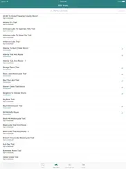
No names. Why not use the trail names? Other then that it looks like a nice app with ability to download the trails
Straight lines everywhere. Straight lines where there are no trails. I did see it mentioned in a previous review, assumed it was fixed. I was wrong. Don’t waste your money.
OK Maps - Needs Work. App is ok. Download the maps before you go. If you want to explore, that’s a lot of maps. And bring a magnifying glass to read, wish it was more interactive. Much room for improvement.. keep going!
Doesn’t show your current location. The current location button is greyed out. Is it supposed to show your current location? That’s the only reason I downloaded and paid.
Forest service roads. Pretty nice app. Developer: why don’t you keep going with it and add the forest service roads and county road two tracks for us Jeepers.
I don’t see maps. I don’t see any maps? Says to filter by trail names but in order to know the names, I need to see them in the map. It’s a catch 22. Perhaps I am missing something but if I am, it’s not very user friendly then
More trails??. This app is wonderful, I’ve been using it for about 2 years and my Dad has had it for longer. He has more trails than I do, but we have the same list of trails. In St. Helen, there is an off trail called St. Helen Trail - 1 or something to that sort. Long story short, did any maps get deleted or is there something that lets me download more? Other than that, amazing app!
Almost worthless. Zero information of where you are on the map or trail. No towns listed. It does give you the ability to delete a route. Not sure why you want to do that. You have to down load each trail map that has a number but you have no clue what area you are down loading. There is no way this person has ever used this app it’s worthless. The moss on a tree gives you more info. No clue what all the different colors or little dots mean.
Best snowmobile app ever!. This is absolutely an amazing app. The GPS is spot on. I didn’t have to pull out a traditional map for our 1,000 mile UP snowmobile trip. The only enhancements that would make this app even better would be daily location tracking and POI/gas stations. Lastly, trail feedback. I’d happily pay additional for these features.
Worked well. Spent a week riding trails. I thought it worked great!!! Used it several time with no issues. Made the wrong turn and got off the trail this app made it easy to get back on the trail
Fix bug!. It will not allow me to download any trail maps. Please fix this issue, or refund people for paying for an app that still has the same issue from a year ago.latest update did not fix this issue.
Grand Rapids trails. Love the app. Any chance you'll be adding the Grand Rapids trails?
Error downloading. Just paid for this and not letting me download the trail I want!! :(
Nothing lower than mid Michigan. Unfortunately this app looks awesome other than there is nothing for the lower half of the state
Fix straight line map glitch. Would be great if the map wouldn’t show straight lines all over. Makes the map difficult to read.
Junk. Completely useless. Unable to download any of the trail maps, ORV nor snowmobile. Don’t spend the money on this app
Great idea, terrible execution. Awesome idea except the crazy straight lines that are supposed to be trails. There is some issue how the map is reading the DNR data.
Did you know that you can earn 25 USD from our site just by registering? Get $25 for free by joining Payoneer!
Imagine you at your best. All the time. Picture yourself at your sharpest and most productive. Your most alert and focused. Your most lucid, creative and confident. At work. At play. In every area of your life. Add Mind Lab Pro® v4.0 to your daily routine and uncap your true potential. Buy Now!
Adsterra is the most preferred ad network for those looking for an alternative to AdSense. Adsterra is the ideal choice for new sites with low daily traffic. In order to advertise on the site in Adsterra, like other ad networks, a certain traffic limit, domain age, etc. is required. There are no strict rules. Sign up!