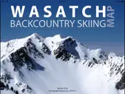
Wasatch Backcountry Skiing Map App Reviews
Wasatch Backcountry Skiing Map App Description & Overview
What is wasatch backcountry skiing map app? The Wasatch Backcountry Skiing Map is the iOS version of the popular paper map and website (visit WBSkiing.com). As with the other platforms, the iOS map includes an index to more than 1,000 backcountry locations in Utah’s Central Wasatch mountains. It is the must-have app for Utah hikers and backcountry travelers.
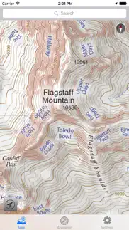
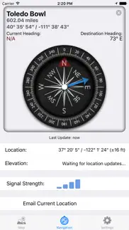
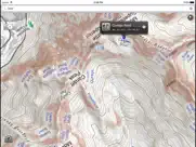
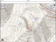
With a familiar map-app interface, the Wasatch Backcountry Skiing Map accesses your device’s GPS to display your current location on a high-resolution topo map. And with only a few taps, the “destination arrow” on the integrated compass will point to your desired backcountry ski location.
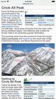
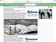
And with a single tap, hundreds of the locations will open the Wasatch Backcountry Skiing Guide website where you can view photographs and detailed information about the location.
The app also displays your current elevation and lat/long, and will send your current location via email. And with a tap, you can display detailed information on more than 200 of the locations including skiing difficulty, skinning distance, vertical climb, parking considerations, and more.
(Contrary to a posted review, you don't need cell service to use this app--you don't even need a contract with a cell service provider.)
NOTICES: When navigating, the “destination arrow” points directly to the destination without regard to hazards such as avalanche paths, cliffs, and rock fall. It is your responsibility to travel in the backcountry safely.
😍 Do you love Wasatch Backcountry Skiing Map app? Please share your friends!

Please wait! Wasatch Backcountry Skiing Map app comments loading...
Wasatch Backcountry Skiing Map 3.5.0 Tips, Tricks, Cheats and Rules
What do you think of the Wasatch Backcountry Skiing Map app? Can you share your complaints, experiences, or thoughts about the application with Iterum, LLC and other users?
Wasatch Backcountry Skiing Map 3.5.0 Apps Screenshots & Images
Wasatch Backcountry Skiing Map iphone, ipad, apple watch and apple tv screenshot images, pictures.
| Language | English |
| Price | $12.99 |
| Adult Rating | 4+ years and older |
| Current Version | 3.5.0 |
| Play Store | Iterum-LLC.WBSkiing |
| Compatibility | iOS 8.0 or later |
Wasatch Backcountry Skiing Map (Versiyon 3.5.0) Install & Download
The application Wasatch Backcountry Skiing Map was published in the category Navigation on 01 October 2013, Tuesday and was developed by Iterum, LLC [Developer ID: 349527491]. This program file size is 88.86 MB. This app has been rated by 502 users and has a rating of 4.7 out of 5. Wasatch Backcountry Skiing Map - Navigation app posted on 11 December 2017, Monday current version is 3.5.0 and works well on iOS 8.0 and higher versions. Google Play ID: Iterum-LLC.WBSkiing. Languages supported by the app:
EN Download & Install Now!| App Name | Score | Comments | Price |
| EMedic Reviews | 4.6 | 16 | $9.99 |
| Avalanche Inclinometer Reviews | 4.5 | 16 | $3.99 |
This update from Apple will improve the functionality of this app. No new features are included. Version 3.5.0 is now linked to the Wasatch Backcountry Skiing Guide. After selecting any of the hundreds of linked-locations in the app and tapping on the "Tap here for more ..." box, photographs and detailed information about the location such as skiing difficulty, skinning distance, vertical climb, altitude, aspect, and slope angle will be displayed in Safari (see screenshot). You can tap on the "WBSkiing" text in the top-left corner of Safari to return to the app. Version 3.5.0 also has a new base-map with dozens of additions and improvements. As always, it's a free upgrade.
| App Name | Released |
| Passio GO | 06 May 2017 |
| Blink Charging Mobile App | 08 October 2022 |
| DC Metro and Bus | 19 November 2012 |
| KakaoMap - Korea No.1 Map | 27 February 2009 |
| NAVER Map, Navigation | 01 May 2009 |
Find on this site the customer service details of Wasatch Backcountry Skiing Map. Besides contact details, the page also offers a brief overview of the digital toy company.
| App Name | Released |
| LocaToWeb | 04 August 2012 |
| Strike and Dip | 30 October 2009 |
| MapOut | 19 March 2012 |
| Pro Compass for Watch | 27 September 2019 |
| Float LOZ | 11 March 2025 |
Discover how specific cryptocurrencies work — and get a bit of each crypto to try out for yourself. Coinbase is the easiest place to buy and sell cryptocurrency. Sign up and get started today.
| App Name | Released |
| Hive Social | 18 October 2019 |
| Telegram Messenger | 14 August 2013 |
| Gas | 27 August 2022 |
| 28 April 2011 | |
| SHEIN - Online Fashion | 19 May 2014 |
Install the Giftmio extension for smart shopping. Get notified about cashback opportunities, activate cashback in one click, and save money on purchases.
| App Name | Released |
| MilGPS | 01 December 2010 |
| AnkiMobile Flashcards | 26 May 2010 |
| Balatro | 26 September 2024 |
| Shotgun King | 24 February 2026 |
| HotSchedules | 30 October 2008 |
Each capsule is packed with pure, high-potency nootropic nutrients. No pointless additives. Just 100% natural brainpower. Third-party tested and validated by the Clean Label Project.
Adsterra is the most preferred ad network for those looking for an alternative to AdSense. Adsterra is the ideal choice for new sites with low daily traffic. In order to advertise on the site in Adsterra, like other ad networks, a certain traffic limit, domain age, etc. is required. There are no strict rules.
Keep personal info private, avoid scams, and protect yourself online with AI-powered technology.
Wasatch Backcountry Skiing Map Comments & Reviews 2026
Not worth $5. This app isn't much more than a geo referenced Topo map. A very confined topo map of the central Wasatch. It does not show approach routes or descent lines. It has a searchable database of route names but not browsable. You'd have to know the name of the route ahead of time. And if you knew that, you probably have coordinates, pictures, route sketches etc. Save your money and find a free app that has a bigger map.
Necessary tool. If you are a backcountry skier in the Wasatch this is not a choice. Get the app!
Must Have. #PointingPeaks with this amazing resource - Great for locating and naming all the meta terrain.
So sick. I use this app to get pitted. But also to stay safe. Slaying gnar and surviving to slay hot and readys from Little Caesars is the name of the game, and this app helps you win. That and avalanche certification.
Fake reviews?. Tons of positive reviews but the app is more or less useless. You can see the names of areas but literally nothing else. Trust the one star reviews, they’ve explained it all perfectly.
Intro. A good introductory map to the tourist or someone new to the area. The map highlights the three most popular backcountry skiing canyons in the Northern Wasatch. I would like to see the app updated to be full screen size of newer devices. Another improvement that would make the app more worth its price is including route descriptions directly in the app; allowing that information to be available offline.
Waste of $$- plz read all the 1 star reviews first. Without being able to download the guide the app map is completely useless. I wish I had read the other 1 star reviews first. This is the most expensive app I’ve ever downloaded and hands down to the most useless. Deleting.
Awesome resource!. Easy to use and a great resource for local skiers.
It's like cheating. If you ride the wasatch buy the app
Use it every time. I use this app every time I go in the backcountry, whether it's to find the name of a chute on the side of LCC as we're driving up, or to find how far I am from my current objective. It's worth the price if you frequent the Wasatch backcountry
Just get a good topo app like GAIA. I thought this app would show specific routes and give terrain ratings for the the approach difficulty and the descent exposure. From what I can tell it has none of those things. GAIA has basically all the information this app has, but the map layers and global topography that come with GAIA are far more extensive and more helpful. The best thing about the Wasatch backcountry app is that it shows local names for areas so you can converse with other people about a route without necessarily looking at it on the map. Not sure that’s worth the money.
Great, changed the face of skiing here. Knowing what the heck the Avy Report was talking about was a breakthrough when this came out. They still manage to name drop obscure places not on the map though- so updating more names would be great. Would also be nice to expand coverage of the map further south to Timpanogos and Provo areas.
So lame. I’m sure all the positives were submitted by the developer’s buddies or are fake accounts. Worthless app. It’s a topo of a very limited part of the wasatch.
Should be free, and is on google. This is just a topo map... there is zero info provided on the named skin tracks or trails
Fantastic Tool. Worth every fraction of a cent. This app is an invaluable resource in the backcountry.
A Wasatch essential. Super happy with this app, and we’ll worth the price. GPS location even when out of service is accurate, and the map is easy to navigate. Elevation is also accurate enough. As others have mentioned, it would be nice to be able to access (offline) info for a specific route that you’re doing that day. It would also be interesting to see an overlay of the route you took (or are supposed to take) for certain routes, although the argument could be made that this takes the learning out of route finding and navigation (fair). All in all, I love it! The extra features would be icing on the cake. I appreciate the work that went into this!
Absolutely necessary for any Wasatch tour. This app is worth every dime. I always have the paper map in my pack (buy that, too), but to say that I use this app a lot is an understatement. The map and guide are easily the best and most detailed resource available for travel in our mountains. It’s a straightforward PDF of the paper map, but that’s all you need. There’s a compass screen that provides heading, location, and elevation, but that’s about it. No fancy trackers or social media connection to bloat the app and drain your battery. Perfection! I do wish that the online guide were somehow available for download for situations in which you want to research a new line because of a change in plans but don’t have solid signal. I understand that keeping the guide online allows for easier updating, but it would be nice if offline access could somehow be incorporated. As it is, I just screencap every possible entry along any planned route before we leave home. The only other feature I can think of that I MIGHT want is for the option to automatically orient the app to your direction of travel. It lets you do this manually and already has the compass display, so this seems like it might be a simple tweak to connect the two elements. But this is a minor thing, and I don’t think I’ve ever sat on a mountain and really wished it could do this.
Poor value. All of the reviews raving about this app must come from people who know nothing about navigation. This app is a complete waste of money and I’m deleted it 90 seconds after opening it. If you need to know local names for each individual face this might be of some use to you (but so is a book). Otherwise, all of the information provided here can be acquired for free and better. Use Avenza PDF maps and you can have USGS topos or a topo on a sat image. All of the ski-specific information is available for free online; take a screen shot of that before you go.
Must have. For the central wasatch there is no greater tool. Sometimes worth double checking slope angles as roll overs etc can get lost between the lines
Wasatch?. For that much money it would have been nice to get more of the wasatch mountain range not just the cottonwoods
Must have. Must have for anyone touring in the wasatch
Good app but misleading title. This app is convenient for trip planning, but it does not cover the whole wasatch range area where backcountry skiing is popular only the three major canyons in Salt Lake Co. I hope it includes Utah Co. and Ogden area as well.
Super limited. Super limited
Useless. App is just a topo map with route names and minimal navigation capabilities. Complete ripoff, would not recommend to anyone.
Nothing on the Midway side. No data toward Midway/Heber
Must have for Wasatch Backcountry. Really amazing app. Must have if you plan to go into the backcountry. Useful for planning routes, looking at what’s ahead, and reflecting after. Really great app for being prepared and knowing what’s out there. One thing I always do too is screenshot the area I toured and using the drawing feature in my camera roll I try to map out the runs, tours, and areas I stopped. Well worth the money. Have fun and stay safe!
SICK. SUPER SICK
No idea what this app does. I can’t figure out what the purpose of this app is. It doesn’t show any BC routes and there are no terrain overlays so it’s useless unless you already know what you’re looking for. If it’s meant for navigation and route planning there are way better apps. I cannot recommend this app at all.
Good for Wasatch. I really like the interaction and easy to find slide info (names of areas). I wish it covered more of Northern Utah, but great for what it is.
Love it. Great tech add to ATing
Fantastic. Great app for skiing Wasatch backcountry. For those moaning about the fact it does not contain every skin track, trail name, switchback and first descent party I say create your own app and ski more to learn about those things. Not everything is served to you on a silver platter; try exploring a little bit instead of complaining.
Great App!. I use this app all the time, and I know this range pretty well. It is a crucial tool if you spend any time touring in the central Wasatch!
Only Salt Lake-Not Wasatch Backcountry. Downloaded the app and the closest location was Cottonwood Canyons. Nothing in the south Wasatch mountains near Provo, Springville, Nebo area. Excellent if you backcountry ski Big and Little Cottonwood Canyons, except that’s not defined in the app map locations.
fine smartphone topographic map. yes it is a slightly expensive too. it is very useful if you travel those parts. and electronics are better when backed up by map and compass.
disappointed. For $13, I wish that the app was more than just a map with labels. When you attempt to get information for the different areas, it opens a link in your web browser to their website (which is free to access), which means you have to have service to access that information. For such an expensive app, I really wish that they had built that information into the app. I had such high hopes for this app but regret spending so much money on it.
Update to stop crashing. There needs to be an update, this app keeps crashing every time I try to open it. Phone has been restarted and still having this problem.
Legit. Awesome app... worth every penny. Get it, climb it, shred it.
It’s an expensive topo map. Not sure why all these 5 star reviews rave about this app. First of all, “Wasatch” is misleading - it’s a topo map that covers Millcreek, BCC and LCC. Nowhere near everything in the Wasatch. Second, it’s just a topo map with the names of popular touring areas on it. The map labels are not linked to any real information. You have to search the route name, then it takes you to the external website for any info which is al free and doesn’t require the app. The app is useful as the topo map is handy for when you’re out touring, but for the price there should be waaaaaaaay more here. It should at least have a browsable database, clickable links on the map, and the locations of popular skin tracks.
Very useful. A friend convinced me to buy this app. I'm happy that I did. It is very useful for route finding especially in places that I am not familiar with. Some of the names on certain lines seem different than what I've heard in the past but not a big deal. Could be helpful in a rescue situation by sending a screenshot of your location (assuming you have service).
Don’t tour in the wasatch without this app!. I use this app to plan if not to navigate on every tour I go on in the Wasatch. It’s simple to use, accurate, and helps me and my ski partners make good decisions in the Backcountry when exploring new or unfamiliar terrain. It’s well worth the money and should go side by side the UAC app if you’re planning on touring the wasatch area. Less complicated than Gaia, but with enough extras to be a powerful tool in your pocket when you’re on the skin track. Pro tip: You can use it while your phone is in airplane mode ;)
10 out 5 stars. If you backcountry,sidecountry,cross country, or downhill ski in in the Wasatch, this app is soooo worth the $$. I even use it hiking! Indispensable knowledge and access to a common language in this mountain range.
So so so necessary in the BC. Support your local org
Amazing!. An essential tool for our wonderful backcountry! Very detailed.
Don’t buy. Nothing works, I’m always outside the map areas, doesn't show any info that they claim. I wasted my money on this for a pic of a map I could have screenshotted off a website.
Excellent Tool. I've been using Steve's map for a couple of years in the Wasatch backcountry, then some friends and my fiancé mentioned I should check out the app version. This is a must purchase, being able to locate yourself or determine waypoints is phenomenal, and sales benefit the Utah avalanche center so it keeps on benefiting all backcountry users. Nice work Steve.
Worth the money.. I use it every time I'm in the Wasatch. Wish they would expand to northern Wasatch.
See map, names and position even without a signal.. This app is very well done. Significant research went into this. This is most obvious from the free desktop app which is also worth checking out. If you want a great, searchable map of the Wasatch that will show your location even when Google can't, this is the app to get.
Sweet app. Great intel. Smooth and easy to use!!
Pricey, but worth it.. I have used this app more times than I can count while touring. The interface is super simple to use, and you don't need a internet connection to use the map. Whether you are skiing, snowshoeing, or snowmobiling, you need this app if you are in the Wasatch backcountry.
Not worth it. Not worth the price for a map
Did you know that you can earn 25 USD from our site just by registering? Get $25 for free by joining Payoneer!
Imagine you at your best. All the time. Picture yourself at your sharpest and most productive. Your most alert and focused. Your most lucid, creative and confident. At work. At play. In every area of your life. Add Mind Lab Pro® v4.0 to your daily routine and uncap your true potential. Buy Now!
Adsterra is the most preferred ad network for those looking for an alternative to AdSense. Adsterra is the ideal choice for new sites with low daily traffic. In order to advertise on the site in Adsterra, like other ad networks, a certain traffic limit, domain age, etc. is required. There are no strict rules. Sign up!
Hugely helpful as long as you have cell service. Hugely helpful as long as you have cell service
Craig's(Avey Forecast Guru) Dream made Reality. I'm been very happy with the app. Used it for many many outings last year. Awesome if you like objective skiing. Pick a notch for your belt research it, then go! Thanks UAC for making this happen!
Love this map. It's so handy to have right on my phone especially when checking out new zones!
Know before u go. This app is great. Use it to navigate with greater knowledge and safety.
Great app!!. It works well and is a great resource. What would make it a 5?--layers... Recommend up tracks, historic avalanches or incline catagories(+35), personal track storage.
Great app, more map!. Wish it covered Am Fork Canyon and also to I-80 on the north.
Awesome App!. A fantastic App! Absolutely critical for my bc adventures. Needs to cover further north/south in future versions :)
Awesome. Worth the money!!
What’s the point?. I purchased this app so I could do research and find out avalanche info for an upcoming ski trip to Utah. Since I’m not within GPS range of the map, I can’t access any special features of the app. It looks like I just paid $12.99 for a topo map that I can get on a bunch of other apps or even government websites for free.
Perfection. Amazing app! So useful and love the pin drop feature
Great. Fantastic
An essential resource. Steve's map is the go-to resource for backcountry enthusiasts who chase powder in the Wasatch front. We use this app all the time and the latest update has added some awesome shading. Thanks Steve!
Favorite app. It makes me want to carry a phone!
Very useful!. This is my go-to tool for planning tours but agree with the earlier comment that a google earth overlay or toggle option would be a huge help at times.
Excellent. Fauckin' excellent
Excellent Tool. I've been using Steve's map for a couple of years in the Wasatch backcountry, then some friends and my fiancé mentioned I should check out the app version. This is a must purchase, being able to locate yourself or determine waypoints is phenomenal, and sales benefit the Utah avalanche center so it keeps on benefiting all backcountry users. Nice work Steve.
As advertised. I think this is a great tool for anyone who regularly skis in the Wasatch backcountry.
Lifesaving. IFKYK
Not complete. Great app as far as it goes, but It needs to include the Wasatch Back and Wasatch County. There is plenty of good back country skiing there where this app would be helpful.
A must for UT backcountry skiers. Love the new update. I don't go out without checking this app, very important to know where you are. This app saved my bacon once before and I'm sure it won't be the last time.
Great map. Perfect gps and map combo for skiing
Great tool for the Wasatch. I wish every touring area had an app like this.
Awesome!. Doesn't need cell service, shows your current location, the extra needle on the compass points to a named location you want to go to, hundreds of backcountry names, etc.
Great digital resource. I have the paper version of this map and usually leave my phone off while my beacon is on but having this resource which will pin point my location if I get too mixed up is really helpful. Definitely worth the price of admission.
Waste of money. This app is essentially a topographic map equivalent to what you can find on google maps for free. Don't plan on actually seeing trails on this map, just trail heads. I am incredibly disappointed.
Not enough. For $12 I thought would get a map which was more detailed and updated more frequently with more info. Otherwise I have to say it deserves 4 stars.
Great app. Great app for touring the Wasatch.
Perfect Wasatch ski app. Wonderful, thank you!
Great, but approaches would be nice. Great app with gps linked map and labeling of all the major lines. Including the common approaches and key skin tracks would make it perfect!
Great wasatch ski map. A must have for wasatch back country.
Very handy and informative!. Always works well wherever you are on the map! (Wish it went a little wider into the Park City area) I love to learn the names of runs and places while I'm out touring, and it has them all!
Good tool. A great map, includes almost everything. Excellent tool for trip planning and while it works in the mountains as well I still prefer the paper version of the map