Hoge Veluwe National Park GPS and outdoor map App Reviews
Hoge Veluwe National Park GPS and outdoor map App Description & Overview
What is hoge veluwe national park gps and outdoor map app? ■ “Download any FlytoMap application for Free! By purchasing FlytoMap All-in-One App.”
■ !! Watch "FlyToMap GPS" app video on www.appreview.com and www.youtube.com !!
[Version: 2.5 - Topo]
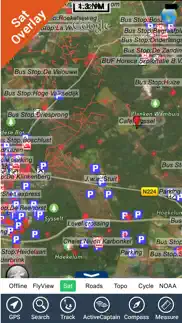
► New Design - Exclusively for the iPhone 3.0: FlyToMap multi-dimensional charts OVERLAYED with Satellite photos and map features.
► The unique application on App Store with this cutting edge technology.
► New iPhone 3GS Magnetic Compass integration.
--------------------------------------------------------------------------------------------------------------------------
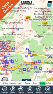
- PARK MAPS:
Park maps are extremely advanced embedded electronic charts with all information collected from the National/State Park and Forest Services and many other local sources. The maps contain all trails (Hiking, Biking, Equestrian trails etc.,) and Points of interests (POI) like Campgrounds, Visitor Centers, Lookout points, Eating places, Ranger Stations, Picnic areas, Boat/Canoe ramps, Parking areas etc. and much more:
“all Trails, Lakes and Rivers within the Parks”
“Park boundary”
“Elevation Contours with 10 meters step” (only "Topo" version)
“Mountain Peaks”
“All Roads and Railways”
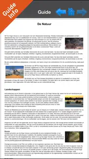
...and full Travel Guide with photos, maps, history, not to miss places.....
--------------------------------------------------------------------------------------------------------------------------
How to use:
“Zoom and Pan fast just by a finger touch”
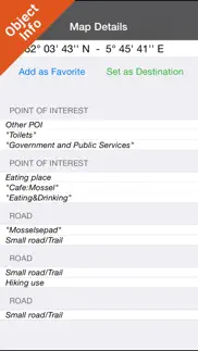
“Use Latitudes and Longitudes to go to your favorite places”
"Record your GPS Track"
“Detailed touristic guide at your finger's disposal”
“Navigate and see your GPS position on the map”
“Geo-Tagged photo management”
“Insert the target/destination ‘Waypoint’ and see in real time your speed, distance and direction to destination”
“Insert Unlimited Markers near favorite places on the map”
“Search your Favorite points or any location by name”
“Set On/Off Elevation Contours if you feel data is cluttering”
- WATER MAPS (Marine):
The new ‘iPhone Marine Navigator’: it contains embedded Electronic Nautical Charts (ENC) from NOAA and Corps of Engineers compressed to store the largest coverage. You can transform your iPhone in a chart plotter with best NOAA-USACE, ENC S57 cartography; which includes Coastline, Anchoring areas, Fishing areas, Restriction areas, Obstructions, Rocks, Buoys, Beacons, Lights, Depth contours (with values displayed in real time on map), Spot Soundings and more. Every effort is made to be as accurate as possible when presenting information for every sea area.
- LAKE MAPS:
High quality lake maps with detailed information and important features compressed to assure the larger coverage. Lake maps contain the most important lakes with detailed Depth Contours, Boat Ramps, Fishing spots etc. Maps also include Trails, Roads and Railways information.
- TRAVEL MAPS:
These Maps cover most interesting touristic areas combining Sea and Land information to allow you a complete travel experience. These are the best Maps to travel on fascinating voyages; map focus on the best Beach spots along the Coastline, Major ports, Sailing, Fishing, Picnic areas, Parks, Hiking, Biking, Clubs, Restaurants, Famous Hotels, Museums, Shopping areas, and much more.
A Travel Guide with photos, maps, history, not to miss places..... is included.
- HUNT MAPS:
These maps are designed specifically for hunting activities.
They contain the best hunting maps of the area with all the information for a safety and unforgettable hunting experience.
These maps are including all Parks, Forests, Trails, Huts, WMA (Wildlife Management Areas), Refuges, Point of Interests, etc. and a complete topographic map (Elevation contours, lakes, rivers, streams, roads, etc.).
A complete Hunting Guide with information about Season, Limits, Licensing, restrictions, etc.......is included.
"Continued use of GPS running in the background can dramatically decrease battery life."
😍 Do you love Hoge Veluwe National Park GPS and outdoor map app? Please share your friends!

Please wait! Hoge Veluwe National Park GPS and outdoor map app comments loading...
Hoge Veluwe National Park GPS and outdoor map 5.5 Tips, Tricks, Cheats and Rules
What do you think of the Hoge Veluwe National Park GPS and outdoor map app? Can you share your complaints, experiences, or thoughts about the application with Flytomap and other users?
Hoge Veluwe National Park GPS and outdoor map 5.5 Apps Screenshots & Images
Hoge Veluwe National Park GPS and outdoor map iphone, ipad, apple watch and apple tv screenshot images, pictures.
| Language | English |
| Price | $1.99 |
| Adult Rating | 4+ years and older |
| Current Version | 5.5 |
| Play Store | com.flytomap.PMDeHgeVeluwePark |
| Compatibility | iOS 9.0 or later |
Hoge Veluwe National Park GPS and outdoor map (Versiyon 5.5) Install & Download
The application Hoge Veluwe National Park GPS and outdoor map was published in the category Travel on 01 February 2016, Monday and was developed by Flytomap [Developer ID: 297575434]. This program file size is 19.85 MB. This app has been rated by 14 users and has a rating of 1 out of 5. Hoge Veluwe National Park GPS and outdoor map - Travel app posted on 04 August 2017, Friday current version is 5.5 and works well on iOS 9.0 and higher versions. Google Play ID: com.flytomap.PMDeHgeVeluwePark. Languages supported by the app:
EN FR IT ES Download & Install Now!| App Name | Score | Comments | Price |
| Great Lakes HD Nautical Charts Reviews | 2.1 | 7 | $14.99 |
| Flytomap All in One HD Charts Reviews | 3.2 | 4 | $14.99 |
| Boating Greece HD GPS Charts Reviews | 1 | No comment | $5.99 |
| Croatia Nautical Charts HD GPS Reviews | 1 | 1 | $6.99 |
| Lake Murray SC Fishing Maps HD Reviews | 2.3 | 6 | $4.99 |
This app has been updated by Apple to display the Apple Watch app icon. Track improvement Marine Weather algorithm update
| App Name | Released |
| Fly Delta | 31 August 2010 |
| Vrbo Vacation Rentals | 19 July 2017 |
| Google Earth | 27 October 2008 |
| Mobile Passport Control | 11 May 2021 |
| American Airlines | 26 July 2010 |
Find on this site the customer service details of Hoge Veluwe National Park GPS and outdoor map. Besides contact details, the page also offers a brief overview of the digital toy company.
| App Name | Released |
| MilSpaceA | 26 January 2012 |
| Prairie State Hike App | 18 May 2013 |
| OBD Fusion | 01 June 2013 |
| Ultimate RV Checklist | 02 February 2019 |
| Walmart Overnight Parking | 29 January 2010 |
Discover how specific cryptocurrencies work — and get a bit of each crypto to try out for yourself. Coinbase is the easiest place to buy and sell cryptocurrency. Sign up and get started today.
| App Name | Released |
| Google Chrome | 28 June 2012 |
| YouTube TV | 05 April 2017 |
| 09 October 2009 | |
| Hive Social | 18 October 2019 |
| SHEIN - Online Fashion | 19 May 2014 |
Looking for comprehensive training in Google Analytics 4? We've compiled the top paid and free GA4 courses available in 2024.
| App Name | Released |
| AnkiMobile Flashcards | 26 May 2010 |
| Paprika Recipe Manager 3 | 15 November 2017 |
| Plague Inc. | 25 May 2012 |
| HotSchedules | 30 October 2008 |
| Bloons TD 6 | 14 June 2018 |
Each capsule is packed with pure, high-potency nootropic nutrients. No pointless additives. Just 100% natural brainpower. Third-party tested and validated by the Clean Label Project.
Adsterra is the most preferred ad network for those looking for an alternative to AdSense. Adsterra is the ideal choice for new sites with low daily traffic. In order to advertise on the site in Adsterra, like other ad networks, a certain traffic limit, domain age, etc. is required. There are no strict rules.
The easy, affordable way to create your professional portfolio website, store, blog & client galleries. No coding needed. Try free now.
Hoge Veluwe National Park GPS and outdoor map Comments & Reviews 2024
We transfer money over €4 billion every month. We enable individual and business accounts to save 4 million Euros on bank transfer fees. Want to send free money abroad or transfer money abroad for free? Free international money transfer!
Did you know that you can earn 25 USD from our site just by registering? Get $25 for free by joining Payoneer!