Elevation For Real App Reviews
Elevation For Real App Description & Overview
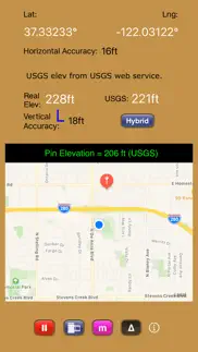
What is elevation for real app? Get real-time elevation from your iOS device's GPS receiver and built-in geoid model.
Also displayed is ground elevation from the USGS Elevation Web Service in the U.S. and Canada, and from the Google Maps Elevation API elsewhere.
Here are some more features:
- Real-time map which displays your location
- Estimated vertical and horizontal accuracy
- Spot elevation data displayed by tapping map
- English or metric units based on your region setting
- Start/Stop button
- One touch screenshots
- NO Third-Party Ads!
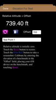
- Pressure altimeter. Measure relative altitudes or calibrate to an elevation benchmark. Use indoors or out. Even works in Airplane Mode! Note: your iOS device must be equipped with a barometer to access pressure altimeter functionality. The iPhone 6 and later and the iPad Air 2 and later have barometers.
Download Elevation For Real today!
Notes:
1) homedatasheet.com, Inc. is not affiliated with USGS. USGS Elevation Web Service is available to the general public online, at no cost.
2) ***The initial view of this app requires a GPS signal to work properly. A clear view of the sky is needed for GPS reception, and it may take several seconds to get a position fix. Elevation for Real will run on devices not equipped with a GPS receiver and GPS-equipped devices that are not receiving a GPS signal, but any resulting elevation readings will just be the approximate ground elevation at your location, even if you are several stories up in a tall building.
3) ***Any elevation measurements with personal safety or financial implications should be performed by professionals with professional GPS equipment. Elevation for Real is not intended to determine flood hazard. Consult a licensed professional in your jurisdiction, such as a surveyor or engineer, when dealing with flood risk.
😍 Do you love Elevation For Real app? Please share your friends!

Please wait! Elevation For Real app comments loading...
Elevation For Real 12.0 Tips, Tricks, Cheats and Rules
What do you think of the Elevation For Real app? Can you share your complaints, experiences, or thoughts about the application with Homedatasheet.com, Inc. and other users?
Elevation For Real 12.0 Apps Screenshots & Images
Elevation For Real iphone, ipad, apple watch and apple tv screenshot images, pictures.
| Language | English |
| Price | Free |
| Adult Rating | 4+ years and older |
| Current Version | 12.0 |
| Play Store | com.homedatasheet.elev4real |
| Compatibility | iOS 26.1 or later |
Elevation For Real (Versiyon 12.0) Install & Download
The application Elevation For Real was published in the category Navigation on 29 December 2009, Tuesday and was developed by Homedatasheet.com, Inc. [Developer ID: 307726715]. This program file size is 608 KB. This app has been rated by 4 users and has a rating of 3.2 out of 5. Elevation For Real - Navigation app posted on 04 January 2026, Sunday current version is 12.0 and works well on iOS 26.1 and higher versions. Google Play ID: com.homedatasheet.elev4real. Languages supported by the app:
EN Download & Install Now!| App Name | Score | Comments | Price |
| WeatherLCD Reviews | 4.2 | 7 | $0.99 |
| Texas Wells Pro Reviews | 3 | 4 | Free |
| IDamage-Pushed Reviews | 3.3 | 37 | $2.99 |
| Exif Wizard-Pro Reviews | 3.7 | 7 | $1.99 |
- Coded in Swift - Uses Google Maps Elevation API outside the U.S. and Canada - Checks which country the user is located in to determine which elevation service to use (USGS or Google Maps)
| App Name | Released |
| NAVER Map, Navigation | 01 May 2009 |
| Randonautica | 19 February 2020 |
| Premium Parking | 22 October 2013 |
| Bluebikes | 11 July 2017 |
| AMap Global | 08 September 2011 |
Find on this site the customer service details of Elevation For Real. Besides contact details, the page also offers a brief overview of the digital toy company.
| App Name | Released |
| Theodolite | 30 November 2009 |
| Speedometer 55 Pro. GPS kit. | 10 June 2012 |
| Land Nav Assistant | 18 May 2012 |
| ADOT 511 Traffic Cameras | 31 March 2023 |
| Knotmeter | 28 June 2014 |
Discover how specific cryptocurrencies work — and get a bit of each crypto to try out for yourself. Coinbase is the easiest place to buy and sell cryptocurrency. Sign up and get started today.
| App Name | Released |
| Gas | 27 August 2022 |
| PayPal - Send, Shop, Manage | 03 February 2019 |
| Hive Social | 18 October 2019 |
| Target | 24 November 2008 |
| Amazon Shopping | 03 December 2008 |
Install the Giftmio extension for smart shopping. Get notified about cashback opportunities, activate cashback in one click, and save money on purchases.
| App Name | Released |
| Earn to Die 2 | 20 November 2014 |
| Streaks | 31 May 2015 |
| Subnautica | 08 July 2025 |
| Ouros | 14 August 2024 |
| Farming Simulator 26 Mobile | 19 May 2026 |
Each capsule is packed with pure, high-potency nootropic nutrients. No pointless additives. Just 100% natural brainpower. Third-party tested and validated by the Clean Label Project.
Adsterra is the most preferred ad network for those looking for an alternative to AdSense. Adsterra is the ideal choice for new sites with low daily traffic. In order to advertise on the site in Adsterra, like other ad networks, a certain traffic limit, domain age, etc. is required. There are no strict rules.
Keep personal info private, avoid scams, and protect yourself online with AI-powered technology.
Elevation For Real Comments & Reviews 2026
Surprisingly Accurate. From the top of the mountain at Snowbird, UT to the coast of NC, this app is surprisingly accurate. If you don't require pinpoint accuracy, this free app is quite handy for those who are casually curious.
Accurate and it does the job.. I use this app at construction sites to verify the elevations of deferent areas and it does the job. Thank you.
Great app. What a great little app! We're house hunting and want to know the elevation of the houses we look at. This does the trick perfectly. We can tell which homes are out of the tsunami danger zone. Just what I wanted when I got the app.
Good app. I just wanted an app that could tell me my current elevation. It did exactly that. Ran fine I have a Verizon iphone4.
Great app, can't beat the price. I was looking for a simple app to show elevation at my current location and this does that nicely. Not super accurate, but wasn't expecting that. Has a very nice user interface.
Well thought out app that does the job quickly. I started this app for the first time indoors when the shades were closed. It still worked! They also explain why most other altimeters for the iPhone don't work properly. Nice.
Great. I've only use this app a short time for search & Rescue. It's a great app. Works very well.
Super!. Hey, these guys are super in creating this app. This is not a toy. This is a pro-consumer app. Great support. Lots of uses and a great learning tool for school kids and curious folks.
V2.4 (current free version) works perfectly in Marin County, California. This app did exactly what I wanted during my walks between sea level and 2750 ft elevation around Marin County in the San Francisco Bay area. Within half a minute or so, it told me what my elevation was, with estimates from both the iPhone 3G GPS and the USGS database, indexed by latitude and longitude. With longer periods of sampling, the two estimates generally converged within 20 ft or so, even on mountain paths. It is really a terrific addition to the phone, complementing the main feature that the built-in Maps for iPhone lacked.
Inconsistent. Looked good at first, nice layout, etc. Temp. In 30s. Several side-by-side elevations clearly yielded flawed elevations (e.g., lower curb elevation shown higher, etc.). Enough unreliability to render the app moot for rough topographic use. Unfortunate.
Fun to know. Informative
Excellent. The elevation reported is very accurate. Also, unlike most other elevation apps this one displays an uncertainty tolerance and identifies the digital elevation darabase it uses.
Great!. I read the reviews and was like this will waste my time. But no I downloaded it and I love it. It works perfectly. It shows the same elevation somewhere, as my google earth. I mean for free, you can't beat it. :-)
Must think I'm in a plane. Shows that I am twice as high in tx than I was on a mountain in Colorado.
Needs work. I live right on the coast and the usgs seemed pretty close to being spot on, the real elevation was horribly inaccurate showing me at an altitude of almost 300ft. Please fix
Works. Works great for me fo sho
Accurate. This is the most accurate elevation app I have found on the App Store.
Did you know that you can earn 25 USD from our site just by registering? Get $25 for free by joining Payoneer!
Imagine you at your best. All the time. Picture yourself at your sharpest and most productive. Your most alert and focused. Your most lucid, creative and confident. At work. At play. In every area of your life. Add Mind Lab Pro® v4.0 to your daily routine and uncap your true potential. Buy Now!
Thank you!. This is exactly what I was looking for. Only thing more I could want would be an option to calculate and show the geoidal separation on iPhone 4/5. This app is worth 5 stars for the 'about' info alone. It not only properly describes the difference in measurements from the ellipsoid and EGM96 geoid but also tells you what the iPhone 4/5 reports when asked for location, something I haven't been able to google despite trying for a while. This app will be invaluable to spot check outputs from other GPS devices to see what they are reporting. Thank you!
Works Great!. This app works really well and you can tell it corrects the elevation. USGS elevation matches topo contour maps for areas I ckecked.
Works well!. Simple to use. Well designed.
Adsterra is the most preferred ad network for those looking for an alternative to AdSense. Adsterra is the ideal choice for new sites with low daily traffic. In order to advertise on the site in Adsterra, like other ad networks, a certain traffic limit, domain age, etc. is required. There are no strict rules. Sign up!