C-MAP: Boating App Reviews
C-MAP: Boating App Description & Overview
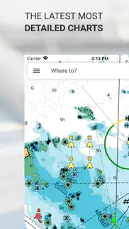
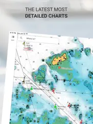
What is c-map: boating app? The C-MAP® App is the perfect companion for recreational boaters and water-lovers. Available on Mobile, Tablet or PC, you’ll always be able to access the most up to date C-MAP charts, wherever in the world you are.
With full features, allowing you to explore, plan and save Points of Interest and Routes from wherever you are, the C-MAP App is the perfect aid to navigation for savvy boaters.
The C-MAP App Includes:
- FREE Chart Viewer
- Autorouting™ – find the best route to your favourite places
- Personal Waypoints
- Track Recording
- Thousands of pre-loaded Points of Interest
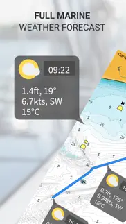
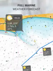
- Marine Weather Forecast
- Weather Along the Route
- Weather Overlay
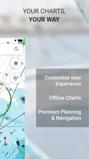
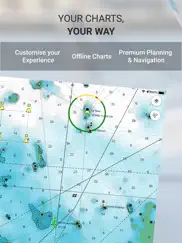
- Chart Personalisation
- Import & Export GPX Files – share your Routes, Tracks or Waypoints with friends
- Measure Distance Tool
Upgrade to Premium to unlock additional features, including:
- Full GPS Functionality
- Offline Map Downloads
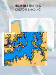
- REVEAL Shaded Relief
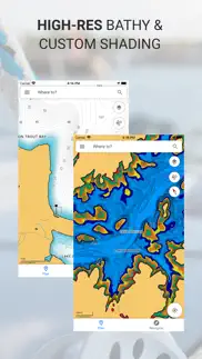
- High-Resolution Bathymetry
- Custom Depth Shading
- AIS & C-MAP Traffic
Try before you buy… Experience C-MAP App Premium for yourself, with a free 14-day trial.
The C-MAP App updates on a continual basis, ensuring the latest, most up-to-date maps are always at your fingertips.
Payment will be charged to iTunes Account at confirmation of purchase. Subscription automatically renews unless auto-renew is turned off at least 24-hours before the end of the current period. Account will be charged for renewal within 24-hours prior to the end of the current period, and identify the cost of the renewal. Subscriptions may be managed by the user and auto-renewal may be turned off by going to the user's Account Settings after purchase. Links to Your Privacy Policy and Terms of Use. Any unused portion of a free trial period, if offered, will be forfeited when the user purchases a subscription to that publication, where applicable
Privacy Policy:
https://appchart.c-map.com/privacy.html
Terms of Service
https://appchart.c-map.com/tos.html
😍 Do you love C-MAP: Boating app? Please share your friends!

Please wait! C-MAP: Boating app comments loading...
C-MAP: Boating 4.3.0 Tips, Tricks, Cheats and Rules
What do you think of the C-MAP: Boating app? Can you share your complaints, experiences, or thoughts about the application with Navico Norway AS and other users?
C-MAP: Boating 4.3.0 Apps Screenshots & Images
C-MAP: Boating iphone, ipad, apple watch and apple tv screenshot images, pictures.
| Language | English |
| Price | Free |
| Adult Rating | 4+ years and older |
| Current Version | 4.3.0 |
| Play Store | com.isea.Embark |
| Compatibility | iOS 12.0 or later |
C-MAP: Boating (Versiyon 4.3.0) Install & Download
The application C-MAP: Boating was published in the category Navigation on 28 April 2015, Tuesday and was developed by Navico Norway AS [Developer ID: 842162153]. This program file size is 161.7 MB. This app has been rated by 1,197 users and has a rating of 4.4 out of 5. C-MAP: Boating - Navigation app posted on 17 April 2024, Wednesday current version is 4.3.0 and works well on iOS 12.0 and higher versions. Google Play ID: com.isea.Embark. Languages supported by the app:
EN Download & Install Now!| App Name | Score | Comments | Price |
In this release we've redesigned and improved the offline maps experience for Premium users. Give it a try! As always, we've also fixed bugs to improve the quality of the app.
| App Name | Released |
| Bonjour RATP | 14 May 2012 |
| Find My Friends Phone - iMapp | 26 July 2014 |
| Find my Phone - Family Locator | 08 January 2013 |
| Blink Charging Mobile App | 08 October 2022 |
| KakaoMap - Korea No.1 Map | 27 February 2009 |
Find on this site the customer service details of C-MAP: Boating. Besides contact details, the page also offers a brief overview of the digital toy company.
| App Name | Released |
| Tide Graph | 12 February 2019 |
| LeadNav GPS | 30 September 2013 |
| Solocator - GPS Field Camera | 09 December 2012 |
| Cachly - Geocaching | 11 December 2015 |
| Phoenix Zoo - ZooMap | 19 December 2021 |
Discover how specific cryptocurrencies work — and get a bit of each crypto to try out for yourself. Coinbase is the easiest place to buy and sell cryptocurrency. Sign up and get started today.
| App Name | Released |
| Amazon Shopping | 03 December 2008 |
| Netflix | 01 April 2010 |
| Hive Social | 18 October 2019 |
| Gas | 27 August 2022 |
| DoorDash - Food Delivery | 10 October 2013 |
Looking for comprehensive training in Google Analytics 4? We've compiled the top paid and free GA4 courses available in 2024.
| App Name | Released |
| TV Cast Pro for LG webOS | 23 June 2016 |
| The Past Within | 02 November 2022 |
| Suika Game-Aladdin X | 06 March 2024 |
| Minecraft | 17 November 2011 |
| 75 Hard | 19 June 2020 |
Each capsule is packed with pure, high-potency nootropic nutrients. No pointless additives. Just 100% natural brainpower. Third-party tested and validated by the Clean Label Project.
Adsterra is the most preferred ad network for those looking for an alternative to AdSense. Adsterra is the ideal choice for new sites with low daily traffic. In order to advertise on the site in Adsterra, like other ad networks, a certain traffic limit, domain age, etc. is required. There are no strict rules.
The easy, affordable way to create your professional portfolio website, store, blog & client galleries. No coding needed. Try free now.
C-MAP: Boating Comments & Reviews 2024
We transfer money over €4 billion every month. We enable individual and business accounts to save 4 million Euros on bank transfer fees. Want to send free money abroad or transfer money abroad for free? Free international money transfer!
Beautiful. Fast. Intuitive. Free!. I spent considerable time this past week trying out C-MAP and other marine navigation apps like iNavX, Navionics, Wavve, etc., in an effort to find the best one to run on my iPad while sailing. C-MAP was the hands-down winner so I felt compelled to write a review and let people know how great this app is. First of all C-MAP stands in stark contrast to competing marine navigation maps because it’s uncluttered and the maps are super snappy and run butter-smooth on my iPad Air. You get intuitive options for distance/time estimating, mapping out routes, basic weather/wave/tide data, your GPS coordinates, even points of interest in the area... and it’s completely FREE! If you choose to upgrade (for just $19/year) you can even see more detailed weather forecasts and AIS traffic on-screen. As a tech CMO and recreational sailor I have to tell you, this app has every single thing I was looking for and nothing that I wasn’t - some serious thought went into C-MAP, from its design and feature set to its user experience. The only other marine app I use (and don’t really need) now is PredictWind, just to get really granular on wind speed and direction. I happily deleted all of the other marine apps on the iPad. If you’re searching for a boating/sailing navigation app like I was, give this one a try. There’s really no need to look elsewhere.
Awful, awful log in experience. So I have two B&G Zeus onboard. I try to log into Embark and the Zeus says there has been a problem signing to your account. So I log into my iPad Pro. No problem. I log out. I try to log in. It says too many attempts. Wait 10 minutes! I log in via magic link on my MacBook Air. I change my pass. I log out. I try with my new pass, it says wait 10 minutes, too many attempts! I get the security idea of the 10 minute hold and I know you were unsuccessfully trying to be secure but if you already let me log in vía magic link and reset the pass then the additional 10 minute hold is not too smart. So here I am, logged out on iPad, logged out on iPhone, and logged out on 2 Zeus devices on my boat. Congratulations, Navico. **** A few days later, Navico contacted me with a workaround. It still involves waiting 10 minutes. I am now logged in. Raising from 1 star to 3 star until Navico gets around fixing the 10 minute timeout that exists even after changing password or logging in via MagicLink.
Will leave you stranded when you need it. This app is horrible. I tried to use it the other day to record a track. After saving the track for the day and then opening it the entire app would just close. Then any time I tried to use automatic navigation it would do the same. This is the second time it’s failed me so I’m done. Use navionics. It works much better.
Pretty, but useless for nighttime navigation. You should not rely on this for navigation. No, not because it isn’t an ECDIS system (I don’t think anything on the App Store is) but because it doesn’t show you what you need to know. The descriptions of lights (eg Fl(2+1)R6s) Are generally not included and where they are, there are errors (San Francisco bay). This might work if you’re strictly a “day skipper”, but anyone that actually needs a chart will find this lacking. The extra star is for a rather nifty auto motorboat routing feature.
Can unhide routes! Navigation line is blue light all of the routes on the map. Despite trying to hide other routes, they automatically become unhidden as soon as you go to the next task. Very bizarre. Makes chart look like spaghetti. Almost worthless. Have contacted customer support but no response in over a week. Also, all routes are in blue but if you are navigating, the navigation line is, wait for it, blue! Just a slightly lighter shade. Very difficult to discern and differentiate. Why not make it red (like my Simrad chart plotter) or yellow or orange or any other color but blue. Makes no sense.
Not reliable.. Unfortunately you need reliable signal for this to work which kind of defeats the purpose of it because when you’re out on the water you do not have signal. I’ll be getting a Garman as there really is no solution to be using these things even though they say the phone has GPS it won’t load the maps. I downloaded off-line version and when I went on the boat there was no off-line map it said update of line map I can’t recommend this to anybody to be confident expect to be confident out on the water with this.
Great when it woks. I’ve been experimenting with C-MAP while doing some offshore cruising on my IPad. I love the layout and functionality of the app; the charts seem accurate compared to Explorer Charts, and the whole design is very natural and easy to use. However, twice now my offline charts have disappeared, and even with WiFi I can not get a chart to load, leaving me with a blank chart. I’ve reached out C-MAP a couple of times with no response; even though I’m a premium subscriber. Deleting the app and reinstalling and then downloading offline charts again seems to get things working again; albeit temporarily. It may be an issue on my end, but I don’t know as customer support seems to be nonexistent. Just don’t depend on CMap as your primary navigation tool until you are sure that it functions properly, long term, on your device. I will update if C-MAP responds and helps to resolve my issues.
Premium doesn’t work. I paid for premium and now it keeps nagging me to pay for premium. After paying, the premium features are not unlocked. Edit: I had to go in and “restore my subscription” to make it work. Still this is a pretty buggy and poor user experience.
What a great tool. I hate reviewing apps. That’s how much a love this app. It has become such a great tool. It has all the needed tools to navigate and feel confident we will get to our destination safely. The night mode is a great feature. It helped creates routes. The app is so customizable.
Sd card. Just bought a c-map discovery sd card. Hope it plays along with I phone. Since I have the sd card I feel like I don’t have to pay for the upgrade on phone. With card I get a free upgrade for the next month. Do I have to register the card someplace?
Longing for Garmin…... I’ve used Garmin and Raymarine chart plotters for years, supported by Garmin’s Active Captain and/or Navionics software. This is my first time owning and using C-Map, which I’ve been working with for a couple of weeks now. First,for the life of me, I can’t get the Simrad GO9 chart plotter (recent acquisition) to sync with my iPhone (Simrad says it’s a C-Map issue and C-Map won’t return multiple emails). Beyond the sync functionality, the C-Map does not have the bottom detail, scope of relief shading and markers/obstructions/navigation detail that Active Capitan by Garmin has and/or QuickDraw support you find in Navionics, as well. All things being equal, I’d go back to Garmin, but for now I’ll just keep hoping someone from C-Map will help me use their product on the Simrad. If the product starts to work and the experience improves I’ll happily update my review!
Great app. Free version is nice. Premium version is worth the money. Charts are nice. Weather is nice. I wish there was a feature were you could put in you range and the app would show fuel docks. All around it’s a great app. I would recommend.
Channel Markers Stink.. Loved it until the update that changed all the channel markers from red and green to all black. Now you can’t pick them up well while piloting your boat. Especially with older eyes. It’s a very simple app to use but I’m thinking about dropping it now that it’s ease of navigation use has been diminished. Go back to the red and green markers. That’s the color they are out here in the real world.
Crashed in the Erie Canal!!. This app is NOT accurate!! It is NOT update to date on markers or new channels/waterways. Showed us going over land when we were in a well marked channel. Didn’t show LOCKS on the Erie Canal which is a huge deal when the canal is filled with rocks and the locks are what get you safe through the canal from Lake Ontario to Hudson River. Ironically where we hit rocks and destroyed our boat is where every local knows NEVER to go but this app didn’t show the lock to the right and we went left and crashed! Should have known something was wrong when the app didn’t show a well known water way by the locals and instead showed us crossing land. Not showing locks in that area or any area that has locks is completely unsafe. Final word of advice .... no boater or local we met had ever heard of this app! Make sure to keep Google Maps and use Garmins backed apps; not this one!
Saved me from replacing my chart plotter. Very intuitive and easy to use. I was going to replace my 10 year old Furuno chart plotters with something touch screen. Instead, I use C-Map in parallel with Furuno. Perfect solution! Also love that all devices are updated with the same route planning and tracks.
Terrible experience. Definitely do not recommend this product.. I paid for upgrade, downloaded charts, but no detail was provided on the downloaded charts (only a rough outline of land features, no depth lines etc.). I tried contacting C-Map support, but there is no way to get through the FAQ page (which was totally unhelpful) to a support person. There is no obvious way to get a refund, so I will have to contest the charge through Amex. Very frustrating. Also, when asked to choose a “nickname” for this comment, any negative name (such as “unhappy” “unhelpful” “dissatisfied”) is disallowed.
Unreliable. Decided to try out C-MAP “Authentication error” made it unusable while at sea with good internet connection. Could not log into my account. I’m a professional pilot and skipper and would not recommend this app for any serious sailor. No response by developer will change the fact that this is an unreliable app for primary use. Thankfully I had other reliable equipment and apps. 2 stars instead of 1 because it has a nice look
Unbelievable for the money and easy to use.. I run inspected excursion boats in the summer and have professional grade electronics on board. I wanted a simple GPS chart plotter for my 20 foot fishing boat but the prices did not justify it. A friend told me to try downloading the C-Map to my iPhone. Definitely impressed with the excellent accuracy of the charting and positioning. We have some narrow and tricky channels around my island. No problem with C-Map. I just ordered a mounting bracket for the phone to attach it to my boat. Captain BillK
App won’t open. My Lowrance and C Map will no longer open. They have worked fine and been very useful but now I only get a blank white screen. I have reinstalled several times with no luck. When I click app support it also goes to a blank white screen. So this is the only way I could report this issue. Hopefully we can get this working again and upgrade to 5 stars?
C-MAP. Best boating/fishing app on the market, how do I know because I have downloaded everyone. It does freeze from time to time, not sure if it’s my iPad or the software, a quick restart always resolves the problem.
Frustrated. I downloaded the app, started the 14 day trial and was setting my home port. The app kick me out and went to the log on screen. I tried logging back in and a corrupted error message continues popping up not allowing me to log back in, I then tried to use my Lawrence app that C Map was married to and I now get the same error message. Really disappointed as this app came highly recommended by friends. I have removed both apps and cancelled the subscription.
Paid for Canada Pro.. Why are Canada charts in feet? No compass rose, I guess when you can choose between magnetic or true north, you don’t need a compass rose or heading. Hope I learn what I might be doing wrong with iPad tablet Well my iPhone has everything I want other than a compass rose and a magnetic north. The iPad Pro will catch up I hope Much better now that I found settings . All I had to do was turn tablet to horizontal. Most plotters are horizontal,I prefer vertical so I have more ahead view. App is working great and am happy with it now
Good App. I use it as a backup to navigation systems on charter boats. Have had a few occasions where it had different info but not too bad. It’s definitely worth the annual cost and with improvements over time, I expect it to be a reliable navigation tool. I will continue to use it.
Not for Intracoastal Use. Downloaded app and charts from St. Augustine to Charleston, specifically focusing on the Intracoastal Waterway. Comments: 1. When adding charts, this app features maps with absolutely no useful or recognizable names. No Savannah, no Charleston, no Jacksonville—nothing that would help you determine what area you were downloading without the use of another map. That’s just plain stupid. All it lists are the tiny, odd little names of surrounding areas. 2. Once downloaded, forget trying to plot between recognizable Intracoastal towns, like St. Augustine FL and Brunswick GA—this app has never heard of Brunswick, the best known hurricane hole in the southeast US. 3. No mention of Intracoastal Waterway whatsoever. Given other reviews, I’m thinking this app works great for offshore travel—but forget it otherwise. Cancelling.
Has some annoying bugs. App requests feedback too often, the pop-up interrupts me when I’m trying to use the app. When creating a route the auto zoom out is very annoying, if I zoom into an area I want it to stay there while I create the route. When tracking a route and trying to zoom in or out you have to hit the recenter button a couple of times to track your vessel movement, it should stay tracking your vessel movement while you are able to zoom in and out. While tracking a route the option to look ahead rather than keep the vessel icon center in the screen (like most chart plotters) should be available, I don’t need to know what the map looks like behind me, I’d rather see further ahead.
New to nautical navigation. While I’ve planned road trips and extended bicycle trips, I’ve never done any nautical route planning. I find C-Maps really easy to use to chart routes. I’ve only been using it for about a week and I haven’t used it to navigate yet. If the navigation works as well as the planning, it’s going to be extremely useful. I’m only giving it four stars because I wish the names of the smaller islands in my area were named on the maps when viewing.
Great Maps and User Interface. Have been using CMAP for two years now. We’ve traveled from Pensacola to Georgetown in the upper Chesapeake bay and back down to south Florida. The maps have been accurate, the auto routing feature saves time and the auto generated routes are easy to customize. Currently planning our Bahamas season and will continue to use CMAPs for the foreseeable future.
Worked great, until it didn’t. This navigational boating app was great until about the last month or two. Seems like it’s completely crashed and they haven’t been able to fix it. It won’t let me create routes anymore, once you go offshore it completely crashes with location, and you can’t even request help because it also gives an error. This was a great app for amateur boating, super easy to just set up where you want to go and head out. I felt comfortable relying on the routes and depths etc, but now it can’t be trusted. Idk if they tried to over complicate the simplicity of the app but it’s unfortunate. Hopefully it gets fixed and I’ll come back, but for now savvy navvy seems like the closest one for me to use on a regular basis.
Dangerous. I am desperate to find a replacement for the greedy Navionics (now Garmin) Boating app so I’ve been trying out everything I can find. I had a delivery yesterday and decided to sign up for the trial subscription to test it out. I couldn’t believe how ridiculous the route it chose was. It ignored navigation aids and channel markers and directed me into dangerous waters and completely unnecessary directions out of the way. At several points it even had me going outside a navigation marker and right over a shallow rocky area! I can’t believe this could happen in a modern navigation app. Other than having ZERO trust in the safety of it’s “auto routing”, I liked the app. I wish it had a little more guidance as to how to use it (the help section goes to a dead website). It doesn’t automatically follow your boat when you’re on a route and there isn’t any clear indication that it is actually FOLLOWING a route. My first chart plotter used C-map cartridges and that was more than 20 years ago. You’d think they could figure this stuff out by now. It’s not quite ready for prime time.
So far so good. 1st time use yesterday in 10,000 islands, Everglades NP. I bought a paper chart JIC and was glad I did. Very little detail. App says I need to download area chart however there doesn’t seem to be a menu option to do this. I justified using it as a GPS for speed and to save my tracks which seemed to work for both. Opened the app this morning and my tracks are gone! Some simple features that looks promising - 2nd day in and there may not be a 3rd...
It’s good for free. If you don’t pay for something and it gives you something you need well that’s great in my book thanks c-maps I’m just getting started sailing and don’t have much electronics on my boat and this app helps a great deal for my trips
Like the app, but it keeps freezing up. Great app, extremely useful. I would give it five stars, except for the glitch. Lately, the app has been freezing up on my iPhone 13. I close the app and open it and it freezes up again. Turned off the phone and turn it back on again, and still no help. Seems to be worse when I go to download off-line maps. It would be great if the developer addresses this complaint as it has become unusable.
Professional Guidance Needs Professional Tools. As a professional running a guide service in the Inland Northwest, the importance of accurate and reliable navigation tools cannot be overstated. C-Map has proven to be an effective and valuable part of my daily operations, however, its functionality could be expanded to better serve professionals in the field. The app’s current reliance on the built-in GPS of tablets and phones can be limiting, especially for professionals like myself who depend on the superior accuracy and reliability of external GPS units. The addition of support for external GPS devices would greatly enhance its usefulness. Equally important to me, as a professional, is the ability to use NMEA data from my boat’s internal network. Incorporating the ability to utilize this data would allow for greater interoperability with existing systems, as the coordinates from the external GPS are broadcast in NMEA format. Despite these areas for improvement, C-Map continues to be a reliable app that I frequently use and recommend. I hope that in the future, developers will consider these enhancements, thereby making the app an even more indispensable tool for professionals in the maritime industry. In its current state, I would rate C-Map at 3.5 out of 5 stars, but with these improvements, I am confident it would easily earn a perfect score. Until then, I will continue to utilize and support C-Map, eagerly awaiting these crucial upgrades.
Sloooow download speed. If you are using it in an area with high speed cell signal it might be fine. But if you need to download charts because you plan to be out of cell/WiFi coverage (like offshore Mexico) save your money or give yourself a few days to download charts. I am currently on day 2 of downloading less than a gigabyte of chart data on a high speed cable connection- apparently connected to a low speed C-Map server. I also run Navionics software and can easily download the entire pacific coast of Mexico and the US in minutes. Currently going on 36 hrs just to download Baja Mexico on CMap. Tolerating it now just to see how long it actually takes. My advice - go to Navionics.
Unreliable. I have used C-MAP charts for years and have little complaints over the accuracy but the app version of the charts has been nothing if not disappointing. As a full time sailor my health and well being is semi dependent on both accuracy and access to charts. Several times over the past year my downloaded charts have just disappeared, also last week the app inexplicably went down with a statement that it would be down for the rest of the month. Luckily I was at anchor but had I been mid passage this would have proven a safety concern. I will be switching to navionics and encourage anyone interested in this app to make sure the have chart redundancy as this app is wholly unreliable.
“Go to” button disappeared?. Hi, I signed up to annual subscription last season. As you have been updating the app all was working good. However this season when I started to use the app, I noticed that the “Go To” button disappeared. I still have an active subscription, however, when I go to account > your purchases> on the bottom it stated that I have an discontinued subscription. It will still work as long I keep subscribing to it. What’s really confusing about this is, I have a normal annual subscription to the premium version. How is this discontinued? Is that the reason I no longer have the go to button? Is was so easy to navigate on the C-map app before, now it is a nightmare. Please help.
What Garmin?. After downloading this all my wants for a Nav on my boat have dissappeared. I tried all the best ones for iOS and CMap earned my business and I purchased the Premium. Woud like to see more specific labels on some of the islands of the Caribbean. For example St. Thomas isn’t labeled at a zoom out or zoom in. These detailes should be checked out.
Newbie. I am new to all of this app stuff for boating. I love the idea of planning from anywhere. I just wish there was a way to transfer information back and forth to my Simrad Evo3 screens... or if there is, then I wish I knew how and I would give 5 stars and gladly pay since Navionics failed so miserably in this game and refuse to give them one more cent.
Easy to learn. I installed C-MAP on my iPad just a few day ago in anticipation of a delivery next week. I found it extremely easy to learn how to build the routs and go back and edit them. I’ll come back and post after we get out on the water and give it a try. Always remember to review your routes several times.
Enjoy this app. Good app. Been helpful even to an old school guy. Gives you best possible way to run and it’s pretty easy to figure out. Of course you need to double check everything but this is a great second back up to your main navigation system
Worthless. App will not connect. Keeps saying there is a network error. I’ve tried Wi-Fi and cell data with no luck. I’m beginning to loose patients with C-Map products. I had one chip fried because of a lowrance update, just bought new maps and they won’t download because of an issue with their website and now this app doesn’t work. I love the charts but does any of your stuff reliably work?!
Very Easy to use great job !!!!. I just bought my first boat and started trying to use the same tool on GO7, for weeks I tried figure out how to plan trips and watched hundreds of videos and finally I gave up and down loaded the app, within a hour I had all my places and routes saved now I am about to buy a iPad Pro to use for navigation tool. I really cant understand how they can make this App so user friendly and almost impossible for a new user to figure out same concept on the GO7 plotter also customer support would be the topping on the cake make it available and hands down every customer would be happy at least I know I would be... Great Job I love the App!!!!
Why are the maps not up to date and depth contours are way off too!!!!. Plz tell me why the maps do t show creeks and lagoons for my country. Sometimes I record a track and it shows me driving through land and sometimes it doesn’t even record my track until I stop and start to record track again. I need some feedback fast cause it makes no sense to buy this app if it’s not giving me accurate readings. U need to update your maps because that is Mis-information and you can cause accidents if you try to follow your maps it’s just ridiculous to have a gps and the naps are not accurate
Will not let me sign in. Will not let me sign in, signed up with “sign in with Apple” option - apparently a big mistake When I now attempt to sign in, I get- “Authentication error” - “ID token expired” I signed up with the with paid subscription… another big mistake Also, if you downland “offline charts” only download one at a time, otherwise it takes days if not weeks to download… attempted to contact the developer, no response.
Tested 3 CMap came out on top BUT. I wanted a planning APP that I could set up next to my B&G chart plotter. The idea was trip planning and back up if I had cell connection with my router. This one works. However, unless I can’t find out how in the instructions which could use depth, I can only add a starting point and end point on a route. CMap plots you on the fastest route without regards to fixed bridges. This is problematic on the Puget Sound with a mast of 65’. I haven’t figured out how to move the route (not in documentation) This is why I knocked off a star. My fix is to create multiple routes. Not the best way but it works fine for planning. Still better than the days of using the divider, parallel, and pencil.
This app was a godsend. My family and I were at a fish house down near port Mansfield on the inner coastal. The GPS on our boat malfunctioned when we were out there. This fog rolled into the area after dark and stayed. I frantically searched the App Store to find a boat navigating app because our guide had no way to navigate us back— you could not see the markers. I downloaded this from the middle of the ocean at 12am in my iPhone and used it to guide me back all the way to south padre island with 50 feet of visibility. It worked great and kept us right in the middle of the channel. My children were with a babysitter back in South Padre. There is no way I would have made it back without this app. I would give it 10 stars if I could . 👍🏼👍🏼👍🏼👍🏼👌🏼👌🏼
Best nav app I’ve seen. This app does everything I want, and includes features I didn’t know I wanted, but love, like showing weather and wind speed for my entire route. Data about currents is missing, which is why I give this 4 stars. The route show direction and speed of currents.
Best looking charts available. Embark has quickly become my favorite charts app. The cartography is top-notch and takes full advantage of a high resolution display. Updates are frequent, and the dev team is amazingly responsive. There are still some features I’d love to see (tidal currents, make it easier to find tide stations other than the closest and predictions farther out than a few days, track export), but they are continuously improving and I keep looking forward to seeing update notifications. I just hooked my B&G MFD up to my account, and I’m loving the way that tracks and routes sync. That feature plus the solid auto-routing make planning a joy- no more standing at the helm fighting the smaller screen and less responsive touchscreen! Instead I can do my planning sitting in an easy chair at home while anticipating the trip! Hats off to the devs for an app that is truly a joy to use!
Nice application for occasional boating use. Wave data seems totally bogus though!. I’ve been using this for a few weeks in test mode and I’m on a Washington state ferry presently, heading to my boat for some winter sailing. I’m looking forward to the routing and tracking other boats via AIS. The wave data in the detailed weather section though seems completely bogus. I’m in an area this morning where it’s absolutely flat no wave, no swell, but the app is reporting 6.2 foot waves and cresting at this location. I tried to submit a response to this fact but the app doesn’t seem to be able to actually connect and send messages back to the developers using the feature in the help and FAQ section. So I’m posting that here in my review.
Good update. C-Map had a pretty serious bug regarding bridge clearances, but I’m happy to report that their tech team acknowledged it and fixed it in about a week. It now correctly shows bridge clearance. C-Map has a lot going for it. Still has some bugs though, but none that I can see that are safety issues. The color coding for water depths, for example, resets every time you open it. They also claim that you can download charts (In Premium only) that cover a wide area, but in reality you’re only downloading the baseline chart. To get the full chart you have to zoom in as tight as you can and then download just those four tiles. Several others have commented on that. They say it’s fixed but didn’t work for me until I downloaded very small (large scale) areas. I tried to download all of Puget Sound in one go and it only gave baselines. But by zooming in over several areas separately, then the downloaded charts worked (tested while both Wi-Fi and cellular were off). I’m holding out hope for them! C-Map looks great. Their auto routing seeeeems to work okay. Lots of little quirks though still. Give them a chance and see what you think.
Did you know that you can earn 25 USD from our site just by registering? Get $25 for free by joining Payoneer!
Great for planning. Just loaded it and am getting the hang of this new program. So far it looks great and although it takes effort to learn it has great potential. In the next few weeks I get a great chance to evaluate at sea. Integrates well with Zeus 3 and my plotter. Took a while to learn how to plan on mg Mac at home as it seems aimed and easier for PC users. An up front intro for Mac users would help. John Mach 1
Great app. Perfect for any boatie and so easy to use. Use it every time I’m on the water ;)
Easy to use. Simple and easy to use, great night mode too.
Recommend. Easy to use powerful tool
Subscription. Hello if I subscribe to C-MAP premium is it available on Apple Mac computer or is it just on iPhone and aneroid? I love the free version and will upgrade and also buy C-MAP for my Simrad evo 2 Regards Robin Stewart
C-MAP. It’s good to be able to see all my waypoints, routes and tracks, but would be better if there were more settings available like change nautical miles to kilometres
Great maps. Easy to use, accurate. Don’t leave home without them
Trip planning. Easy to use
Great app. Worked well today to show the right way to go in an unfamiliar place. 👍
Authentication Error. Installed, tried to log in via numerous methods, authentication errors for all of them. I don't have time to be wasted on apps that I can't even get into. How hard can it be? Deleted, I will go try something else.
Great App - easy to use. Great app,easy to use. Clear maps, good night mode
Thank you for fixing c-map. I though I’d lost all my gps marks and routes with the prior upgrade. Thank you for fixing c-map. Love it.
Was a great app. I loved this app, but then they done an update and it hasn’t worked since. Can’t contact anyone from app, website hasn’t answered. Paying for subscription that I’m unable to use. Disappointing hopefully they can fix it but not holding my breath
Boat trips. Easy to use plenty of options and detail
C-MAP auto pilot. I have been using this with Simrad evo3 and it’s great set a course tranfer to Simrad and execute work brilliantly
User friendly and quick. Great to have saved spots at your finger tips when using the sounder for down/sidescan full screen
Gear app. Really recommend this app easy to use and has everything
Thanks. Very good app would be good to see the navigation location pin drop be optional, it can be quite sensitive to a brush of the finger when you’re really trying to zoom in on good ground
Very disappointing. One feature I was looking for isn’t available, or at least not easily found, is the ability to edit positions. The only way I found was to drag the map. To me this is dumb, I should be able to enter or modify a position by numeric means and not restricted to graphical means. Example, if I get a waypoint from someone written on a napkin, how do you suggest I enter it in this app? Needless to say I will not use or recommend this app because of this dumb implementation.
I use this app to do all my pre-departure planning. I use this app to do all my trip preplanning and as a secondary navigation aide onboard my vessel. It can have the odd glitch after an IOS update but overall I couldn’t be happier with it.
App is good, but the wind overlay…. The app is really good, but the wind overlay doesn’t work the well. At this point of time, it got bug, and The wind overlay doesn’t show up at all
Great app. Great app for phone just need a little less sensitive touch screen when on the water and your phone screen gets wet
Very happy. Great detail, my go app when I’m looking for new ground
Way points.. I can not enter way points such as fishing spots and when I go to help to ask how or can I enter them nothing happens can not get through to any one very frustrating an disappointing if I new I could not do this I would not have purchased the app very disappointed in this app .
iPad. Hey I use the app regularly on my phone. Absolutely love the app. I am truing to add the app to my IPad. I have the correct running version but it just won’t open. Wondering if you had any ideas ? Thanks Jason
Perfect emergency map. First I used it only if nothing else worked but now I use this map at every trip
Loving C-Maps. Really enjoying learning my way around C-Maps. It’s very intuitive to use and has great features. Easy to navigate a route. Easy to read icons. Looking forward to learning more as I go.
Don’t waist your money. Apps good when it works, haven’t been able to access it for the last few days, and product support is not available, save your money people there’s better on the market
Navigation Charts. Well it’s getting better pretty ok for a free app has a beta charmer now with more contour lines needs to have bottom info eg at anchoring point is it sand rock reef ect Hope in time it improves I’d certain pay a small amount to have that functionality
C Map Embark. Easy to use can’t wait to use sailing tomorrow and storing our track to review later.
Great Nav. Simple and easy, still discovering features.
Just what I needed. This app is fantastic and just what I needed to plan offshore trips without taking out the gps/ chart plotter out of the boat . Easy to use and very accurate I have found . I also like the weather info and navigation information that is easy to access everyone should have this if your serious about fishing /boating C-MAP is a deadset winner 😎😎😎
Does not work. Downloaded and had a look. I like the maps/chart layout but I can not start my subscription. I click the free trial button and nothing happens I have updated and rebooted the app and it still doesn’t work. 🤷♂️
It took a re-install. It took a fresh install of this app to get it working again after the latest upgrade, hence the 4 stars. At least all of my saved data and waypoints carried across, and it’s working as it should again. But it still shouldn’t need to be re-installed.
Quite good app. Would recommend this to others. Has extensive maps. Easy to use but would be handy to have a legend for what all the symbols mean on the maps for first timers.
Kitto. Finding this app more accurate and easier to use than the navigator in my boat
Hex review. The best app I have ever used easy to use and all the right information. Thank you c-map .
Cmap Embark. This app is the best thing on my phone. It is easy to use, reliable and extremely accurate Thankyou to its creators...Phill 😀
Great app. Allows me to see everything accurately easy to use
Login issues. Have purchased C-Map 4D for our boat online and am running with Expedition nav software. All good. However, downloaded the app to my iPad and have the following problems. 1) The app wants me to chose between signing in with Apple, FB or via an e-mail. Selected e-mail as I already have an account. I can enter the e-mail address, but the next page asks for a new password - no option to sign in to my current account. 2) In addition to no option for existing account sign in, the keyboad does not pop up when I click in the text box for “new password”. Help... Roger
Missing the create route using places. I had a response to a review but you missed the point. With the upgrade I believe we lost the ability to create a route from the saved “Places” (waypoints) list. Now creating a route manually creates a new waypoint every time regardless of passing a saved place. I literally have over 300 route points that make no sense such as 25 “Routepoint 5” for example in my places directory. Clean this up and allow us to create a SAFE route where we can view it with proper preloaded places, and the app is 5 star!!
Good app, needs things fixed though. App is great and quiet accurate! Use it all the time however it does needs some bugs fixed, majority of the time when putting in coordinates the app does not allow numbers to be typed into the box which can be very frustrating when trying to get to coordinates given to you.
HomeHarbour. I am a first time user and for a free app so far so good. However it is a little glitchy at times and some simple features don’t seem to work, for example, I am unable to save or set my home harbour even after following instructions 101!
Great app. Love the app as I can plan trips and add points away from the boat and it links up to my sounder when we take it out… no more loosing gps points. It is soo good.
Mid range Nav app. Has all the features i need, a little slow to track when cruising at 20 knots
Dangerous. Do not rely on this app for navigation. I’m currently in the middle of Bass straight yet this app says I’m in southern Tasmania at an anchorage I was at 4 days ago. At other times it has logged me out and won’t let me log back in without internet access. Lucky for me this was not my primary navigation device. Has a automatic routing feature but doesn’t save route when you try. I wouldn’t even recommend as a redundancy option.
👍👍👍. Excellent detailed maps and user friendly.👍
Missing C-maps. Hi guys wondering when the App will be up and running again as we are unable to still log in to our account. We are sailing Tasmania in the winter wonderland and we are missing this app cheers
Using Map around the world. Great everywhere
Unsure. Signed up to the sub, and there are lots of options. But all the weather options don’t seem to be working for me. Wind, wave height etc just change the land colour with nothing at all indicating anything of value.
Imagine you at your best. All the time. Picture yourself at your sharpest and most productive. Your most alert and focused. Your most lucid, creative and confident. At work. At play. In every area of your life. Add Mind Lab Pro® v4.0 to your daily routine and uncap your true potential. Buy Now!
Still not working. App still not working from its originally outage from weeks ago. They just renewed my yearly subscription yet it’s still not working.
Excellent program. Excellent program
Yee. This app is really good for when im out on my boat and works just as well or even better than a traditional nav system
Measure tool not working. I’m having the same problem as one other person in the reviews. The measuring tool is not working. It only shows a few feet even though I move the cursor a few miles. The reply from the developer is thanks enjoy the app, the reply is 3 years old. No explanation or assurance that they are working on it. I cannot get through on the phone lines waited over an hour on both the direct line and 1-800 number. What good is an app without product support. Also when I click on the product support link on the listing in the App Store it just opens the app to the home page. No support nothing. I will cancel my subscription.
Disappointing and Expensive. This app discredit’s c-map’s otherwise great cartography! Won’t open consistently or identify location while navigating. Seems to always need to be connected to the internet even after downloading charts! Couldn’t even get the ‘contact support’ feature in the app to work! Feels like this was created by people who don’t actually go boating. Regret purchasing as it’s ‘buggy’ and not reliable for navigating.
Top 1. Top 1
Tellement utile!. Application simple d’utilisation et très pratique! Un incontournable!
Service Outage While In Use!. I have a paid subscription and while out boating on the water using the app for navigation the app shut down and I got a C-Map system Service message saying that CMap is currently down and is not expected to be online until June 25th. That’s 8 days away! Not only did CMap put me in a dangerous situation on the water - but shown me that they don’t care about their clients. There is no reason for my app to disable itself. I have offline maps enabled that I could be using instead of the their wireless ones. Only the app won’t let me access anything! So disappointed.
I use it everytime I'm on the water!. Safe! Reliable!! Easy to use!!! Boat on western Lake Ontario
Best nav app. I try 4 nav app before i try this one. No need to get anither one this is the best one.
Can’t trust for navigation. This app very often fails to load. I added it as a potential nav backup for sailing but I have zero confidence it will work when I need it. I have deleted and reloaded the app and installed all updates but it just does not work reliably.
Simple et efficace. Simple d’utilisation, mais ne remplace pas les cartes papiers 😉👍
This a toy not a tool. If you are looking for a tool to automatically plan routes don’t bother with this.
Day trip to Gauja River. We started our trip from Daugava River and it took us about an hour to arrive to Gauja(at the speed of 34 km per hour). We stopped at the beach, where the river ends. There were nearly not as many people there as at the other communal beaches. Mostly, people go here using a motorboat or a smaller sailboat, since it’s quite deep here. It’s an outstanding location to visit!
Great app. Thank you for the great app, so useful!
Doesn’t work they want more money. I am very disappointed with this app. I had premium and now you want more money for it and have cut off all of my services even though I am paid up until Dec 2021. This really messed with me when I went out on the boat and couldn’t access this navigation app. This is dangerous.
Jdjdjfm. Hshshdhdhfh
User Friendly and More Details!. I use C-Maps more and more as I have found that it is much easier to find names of places on c-maps than Navionics. It is more user friendly in general. The only thing i haven’t figured out yet is how to bring up the Tide Chart. Great work C-Maps!!
Very good apps but some bugs to be fixed. With the last version 4.2.2, when I use the measurement function the distance appears in feet and the value is completely wrong. Apart from this problem, this is a very good application.
Great tool!!!. Great maps and features you can depend on
Super navigation. Great app didn't get lost!!!!
Canadian Great Lakes sailor. Very good chart detail wrapped in a nicely designed app. However, nearly all islands are not named. Names are shown for straights, channels, and few bays. If you want to cross reference with a cruising guide this reduces the app’s utility. I have been unable to identify a way to see a place’s name. Tapping land could reveal a name, while tapping water drops a pin. For instance in the North Channel of Lake Huron, Darch, Innes, Croker, John and Aird islands are unlabelled. Benjamins and Hotham are. In C-Map’s favour, they can be found by search, even the obscure Booth Rocks at the back door to the Benjamins
Amazing however. This app has made Georgian bay boating so much easier highly recommend it. I can’t seem to download offline map. I think that it must just be a glitch. It says when I try to download an offline map that the area is to large, however there is no way to zoom in the map is just blank
Problème de connexion. J’étais sur la période d’essai de 14 jours et le système à éprouver des problèmes pour près de 3 semaines! Impossible d’accéder à l’app. Ils m’ont facturé l’abonnement premium malgré tout!! Cette façon de fonctionner est complètement illogique. Jamais je ne recommanderai cette application. Aller avec d’autres compagnies fiables qui ne vous laisse pas tomber en tant que client.
Easy used. Facile à travailler
C-Map. Excellent app. Very easy to use.
Carte précise et efficace. Facile d’utilisation, carte précise et efficace
Great. App
A bit confusing. Maybe I need to pay for it.
10/10 parfait pour plaisanciers. J’ai découvert cet app et ma version gratuite est sans faille. Parfait pour sortir sur l’eau.
Very detailed. Easy to use
Stopped working. After the latest update the app has stopped working. It stalls saying it’s “Setting up charts. This might take up to 1 minute”. That started hours ago and I’ve restarted the app several times, and also rebooted the phone (iPhone XS)
Cmap. Great boating app.
Great for planning. Awesome app for planning routes, distances, and saving tacks for fishing.
Doesn’t show your location in newest update. App was great for heading out on the beach at low tide or paddling around in a kayak in prior update. DO NOT UPDATE AS THE APP NO LONGER WORKS (unless you like to guess where you are on the chart or pay a huge premium …)
J’aime. Très bonne application
New Update Helped. This is a good software and nice to finally have an alternative to other more common programs. My main point I don’t like is that recording tracks automatically delete if your device goes dead or restarts and even sometimes when the device does not restart. Please keep the updates coming. Thank you.
CMap. Dry useful
Waste of $ DONT BUY. App wont load consistently, glitched out on ocean and inaccurate gps readings. For safety sake dont buy. Waste of $40 wish i could get a refund!
So far so good. So far I have only been using C-Map for planing purposes and like what I see. Once back at my boat I will try it out sailing, where it will be my backup system and see what it is like. For now it is easy to set up waypoints and join them on a route. I did have one scenario where it wouldn’t let me plan a route they way I wanted to sail it. I will play some more and see if I can figure out what I did wrong. Therefore four stars for now.
Buttons don’t work well on an iPhone 12 Pro max. The app is great, but the buttons on the top right and top left don’t work well on this phone due to the way the screen curves in the corners.
App. Nice app with great charts.. i feel like this needs to be more straightforward for planning a route. Picking the origin and destination quickly seems cumbersome.. I have often had to resort to Navionics for this basic function. Cheers C
Too many bugs. I’ve been using the app for three months. When I open a saved route, often all I get is a blank white screen - no menu, no buttons, just blank. I have to quit the program, restart the app but it happens again. Rebooting the device does not help. My only option is to recreate the route again - very frustrating. When I select the same route on my iPhone 13, it is there but the Edit button doesn’t do anything. So it’s just dead. I tried to submit this feedback to C-MAP through the app contact form, both from iPad and iPhone, and it would not go through. Just returned the message: An error occurred. I’m switching apps, this one is a waste of time.
Paying premium member, but not working now. I have used the contact C-Map feature inside the app three times now with no contact back, the reason I have been contacting CMap was to let them know I have been a premium member since July 2020 and all of a sudden the app has stopped giving me premium features, even tho my premium status is good until my next billing date of July 2021. I’m a very upset customer, totally let me down when I needed mapping that I paid for.
Works great. Highly recommend
C-MAP. Bonjour, J’ai obtenu C-MAP, par erreur. Je ne désire pas essayer cette application, et je ne désire pas m’y abonner. Je vous demande d’enlever C-MAP immédiatement et de considérer que j’annule C-MAP. Michel Pelletier
Works great except a few Ui issues. Works great just have issues working with the iPhone pro max as the ui overlaps the time and battery information on the phone. If fixed would be a 5/5
Ease of use and accuracy. C-Map is a very trustworthy navigational aid. Very easy to use and accurate.
Very difficult to use. It seems like a good app except that I find it very difficult to use. I’m so sorry I wasted my money on this app. First of all it’s not really an app because you can’t download it into your iPad it insists that you must go to the website to sign in so it means you must be online at all times. It randomly signs you out for security reasons it doesn’t care if you’re navigating in a narrow channel your out until you can sign back in again.It’s so sensitive if you go to scroll the map all of a sudden you’ll get 1/3 of your screen covered with a pinned location notification. It says that you can use it off-line but I can’t find the instructions that say how to do that so it’s actually useless for what I bought it for, I wish I could cancel and get my money back.
Like it so far.. We are planning a trip to the coast like it so far.
Adsterra is the most preferred ad network for those looking for an alternative to AdSense. Adsterra is the ideal choice for new sites with low daily traffic. In order to advertise on the site in Adsterra, like other ad networks, a certain traffic limit, domain age, etc. is required. There are no strict rules. Sign up!
Great navigation app. I use this with my boats GPS system and it is a great back up. There are times that I make this primary and use the boats GPS as secondary. It is always spot on
can’t get wind feature to work. I actually really like this app for planning and navigation while sailing. I have used it in the past for wind direction and strength planning but it fails too frequently when I select the “Wind” overlay to get even 4 stars.
Worthless. App will not connect. Keeps saying there is a network error. I’ve tried Wi-Fi and cell data with no luck. I’m beginning to loose patients with C-Map products. I had one chip fried because of a lowrance update, just bought new maps and they won’t download because of an issue with their website and now this app doesn’t work. I love the charts but does any of your stuff reliably work?!
Need legend. There are several symbols on the lake that I ride on and a legend of the symbols would be very helpful...!or maybe a descriptor if you hover over the symbols. That’s the only thing holding it back from 5 starts instead of 4.
The best marine navigation app. So far the best I’ve seen. I bought iNavX that was suppose to be the best and not even close. This looks and feels like google maps for boaters. 100% recommended.
Ugh, these icons are not good. The icons you had before were a lot better. Additionally, iPhone vs iPad functionality feels off. On my ride today, I couldn’t click on anything on the water to ID via my ipad though it worked via my iPhone.
Very Handy. So far using the free app has kept us from running aground a couple of times. I’m becoming more interested in the Premium version
Novice using this. I’m a novice boater and this app has been very helpful. There are a ton of options if you know what you’re doing but I just keep it simple.
Love it. Great app. Missing a few names of ledges and stuff but the detail is way better than my garmin. 5 stars all day baby
Hidden gem. What a good app to navigate by. Really easy to use and helpful to find the routes to your next destination
Top notch plotter!. This app is awesome and is a must for boaters. It’s great having a backup system to my new Expensive Garmin and has already helped me out!
Nice features. I really like the fact that I can sit on my couch and drop waypoints of places I want to fish. The sync feature works flawlessly with my lowrance hds carbon units. Only down fall I see is I wis( you could get a satellite overview on the map. Fix that and this app would be 5 stars.
I purchased premium subscription. I purchased a premium subscription from them and they won’t let me view anything. They charged me for it and everything and I was able to see everything for about two weeks then they cut me off after they charged. I want a refund or to view the maps I paid good money for
Great app for course planning. I use it weekly for double checking my routes, headings and bottom areas
Love this app.. Would also like to see a map presentation based on RNCs, but that’s probably because I’m nearly sixty and used to the look of paper charts.
Great app but needs help with dynamic island. Looks like a great app, however, useless at times for me using iPhone 14 Pro because some screens within C-Map are under the dynamic island area of iPhone OS and one cannot touch the buttons to control app.
Great. Must have for fishing. I do recommend updating more fishing places like have a spot to search places to take family fishing or loading nearby not just big marinas
Love it. Simple and user friendly perfect for my use on the Ice in my local area. Great detail and options to edit your locations.
Great app. Great app with extensive features. The UI is pretty user friendly as well but would like to see a key for the map for newbies who don't have all the symbols memorized.
C-Map Review. I’m only giving four stars because the offline download maps won’t zoom in lose enough to see any lake contour lines. Other than that it’s a pretty cool app.
Amazing!. First year boaters. We navigated in the dark around many obstacles and made it safely. This app allowed us to explore with confidence. Amazing first year of boating. Better than a high price GPS!
App won’t open. My Lowrance and C Map will no longer open. They have worked fine and been very useful but now I only get a blank white screen. I have reinstalled several times with no luck. When I click app support it also goes to a blank white screen. So this is the only way I could report this issue. Hopefully we can get this working again and upgrade to 5 stars?
Pretty and easy to use. The app wasn’t working for me, and the developer personally contacted me and helped fix it for me. Works great. Very detailed and helpful at planning voyages and day trips. Fun to look at too
Easy to use. Once you figure out how to create a route from someplace other than where you are it’s very handy for planing a long multiple stop cruise. The program could provide better instructions, but I eventually figured it out.
Opportunity. I’m glad to find and use this app. We are just getting started in planning our first trip with our sailboat
Easy and fun. Just a note to say this is a great back up and learning tool for my kids.
Love this app can’t wait to use it. Have Ben looking at lakes I want to fish and love the details that I am seeing! Can’t wait to use this on the water with my lowrance gen 7s have Ben updated with C-MAP!
Super helpful. Super helpful for keeping my boat out of shallow water. I really like the route planning feature.
Reliable and easy to use. I use this every time I go out on the boat, hasn’t been wrong once. I use it to navigate in unknown territories
Best free mapping app. This mapping app has the most detail and markers without “unlocking “ the paid version. Weather, tides, route planning. Marinas and their phone numbers…. Lots of great information
New user. Things seem real easy. Still getting to understand things but easy for a beginner like me
C-map saves the trip. Great trip to American shoal, a little while back. Inclement set in and the mapping worked perfectly to get us home without any concerns.
Easy to use. Very easy to use maritime app, i am a beginner in navigating and marine boats, loved the simplicity to use and the added weather, tides and all info available!
C-MAP. Use it all the time; great backup to navigation or to study and reference while planning a trip.
Best Maps Out There!. Thank You Thank You Thank You!! Absolutely the best maps out there and a god send for offshore deep fishing! Worth every penny!
More then expected. It’s really good and reliable. We work of tug/barge and a tight spot and we can see all the rocks around for a accurate pin point. And no delays on the signal from gps.
So Far So Good. I’m getting ready to take this out on the water and it shows great potential.
Nice app, lack of support. Nice app, lack of support. I’ve been having an issue downloading maps offline. It’s been over a week now, and I’ve yet to receive a response despite multiple attempts.
Perfect for planning. Replaced most of my use of papercharts. The ability to create routes and measure distances are very useful. Since I am sailing I appreciate the easy visual depth information.
No legend. This app seems fine enough but there is no legend for the nautical symbols, which could be useful. There also there doesn’t appear to be a clear indication as to whether the depths are in feet or meters. Do we know which it is? It’s most likely feet, but the international standard is meters or fathoms and being able to switch between them would be helpful as well.
Great maps. I have used other maps and they work good but this one is spot on and you can link it to your Lowrance.
Maps deleting. I have the same problem. My offline charts disappear. I will write to customer support. Also, I would like to find a legend telling me what many of the symbols represent. I’ve tried referencing nautical charts but it wasn’t much help.
Better than Navionics. I have navioncs and c-map, honestly if I would have to choose C-MAP wins. It’s got a cleaner look, the info and detail is about the same on both.
Love it. I use this on my iPhone every trip... love it!!! Have many routes saved and ready to go…. I pre plan/route our trips prior to!! Awesome ⚓️🇺🇸
app crashes and deletes tracks. This app would frequently crash while navigating with the “track” function enabled. Once restarted, all tracks would be cleared. Very inconvenient when underway. Otherwise, I really enjoyed it - if they would fix this crashing issue it’d be 5/5
C map ap. works great use it on Lake Champlain in Vermont very accurate very easy to use lot of great detail I recommend this ap to any one that liked to boat or fish
Easy to use. We have tried a few other Nav programs and this is one of the easiest
This app has become absolutely useless. Charts don’t load and new login is ridiculous.. Now in the email option for logging in worked for me. Thank you for fixing this. But why require people who haven’t used the app in a while to go through this? With our boats hauled now many of us don’t look at nautical charts.
Nice charts but…. Auto routing takes me over 1’ areas when there are good depths along another path. Saved routes when accessed crash the app leaving a blank page. The app sometimes refuses to open. Not something you can count on.
C map. I use this app on the regular and it is pretty accurate it shows places that other apps like this do not