US Public Lands App Reviews
US Public Lands App Description & Overview
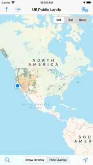
What is us public lands app? The US Federal Governments owns nearly 650 million acres of land - almost 30 percent of the land area of the United States.
These are lands that are held for all Americans.
US Public Lands allows you to quickly retrieve the boundaries of these properties without carrying physical maps, books, or digging deep online.
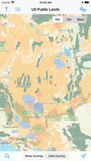
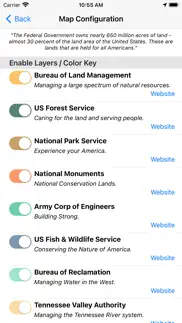
Included in the app are on-device (fully works offline), individually selectable & beautifully colored map layers for most of the properties administered by the federal government:
- Bureau of Land Management (BLM)
- US Forest Service (FS)
- National Park Service (NPS)
- Army Corp of Engineers (ACOE)
- US Fish & Wildlife Service
- Bureau of Reclamation
- Tennessee Valley Authority
- Department of Defense (military bases & installations)
- Other (National Laboratories, Test Sites, etc...)
Key Benefits & Features
- Know which US agency owns and operates the land you're on or are heading to. Use the "Layers" icon to select which agencies you want displayed to create your own custom map. (Hint, the toggles are color coded to the color each layer is displayed in.)
- Links are provided to each agency's website within the app, so that you can further your research as to what land use rules apply for each public land type - such as permits, fees, activities allowed, and limits of stay.
- Map layers are stored on device - no internet connection required.
- Be sure to turn on the 'Basic' base map to see the US Public Land labels for each land area. This base map layer is also stored entirely on your device, and can be utilized if you do not have an internet connection or would like to conserve bandwidth.
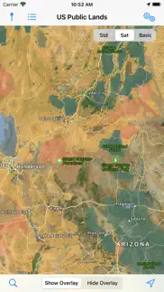
- If you have an internet connection (or have cached them before going out of signal), you can utilize the built in Apple Maps and satellite view maps as the base layer underneath the public land overlays.
- A boondocker's assistant - While US Public Lands is not specifically a camp site locator and does not have a database of specific sites, by turning on the satellite view map, you can better scout out trails, roads and signs of dispersed camping locations within the boundaries of the public land resources.
- Quickly toggle between 'Show' and 'Hide' via the "Map" icon to more clearly see satellite images below.
- If you have GPS access on your device, click the 'Locate Me' icon to show your present location - know what type of land you're on right now!
- Built in search tool locates anything on device maps supports (requires internet access) - including cities, states, zip codes, addresses and points of interest. A pin is dropped at the search location.
Thank you to the Protected Area Database (PAD-US) of the U.S. Geological Survey for providing the public domain raw map data that we’ve been able to utilize to create this interactive overlayable mapping & navigation tool. We will update our maps in the future to stay in sync with improvements to this data set.
Please note, the USGS PAD-US database contains the “most up-to-date aggregation of Federal lands and waters” available, but this database is still evolving and some locations may not be listed and others may not have precisely accurate boundaries. Resolution across the nation may vary. And always remember - there may be private unmapped inholdings within any public lands - so always pay attention to local signage, indications, and information.
The US Public Lands app should only be used as an overview, and you should always confirm more precise details by consulting local field offices, administration websites, and other resources. Do not solely rely on this app for determining if you are on public or private land.
😍 Do you love US Public Lands app? Please share your friends!

Please wait! US Public Lands app comments loading...
US Public Lands 2026.3 Tips, Tricks, Cheats and Rules
What do you think of the US Public Lands app? Can you share your complaints, experiences, or thoughts about the application with Two Steps Beyond and other users?


US Public Lands 2026.3 Apps Screenshots & Images
US Public Lands iphone, ipad, apple watch and apple tv screenshot images, pictures.
| Language | English |
| Price | $3.99 |
| Adult Rating | 4+ years and older |
| Current Version | 2026.3 |
| Play Store | com.twostepsbeyond.public-lands |
| Compatibility | iOS 15.6 or later |
US Public Lands (Versiyon 2026.3) Install & Download
The application US Public Lands was published in the category Travel on 11 April 2014, Friday and was developed by Two Steps Beyond [Developer ID: 371852083]. This program file size is 183.66 MB. This app has been rated by 745 users and has a rating of 4.4 out of 5. US Public Lands - Travel app posted on 01 April 2026, Wednesday current version is 2026.3 and works well on iOS 15.6 and higher versions. Google Play ID: com.twostepsbeyond.public-lands. Languages supported by the app:
EN Download & Install Now!| App Name | Score | Comments | Price |
| State Lines Reviews | 4.2 | 19 | $4.99 |
Updated maps to PADUS 4.1 Added ability to backup and restore pins. Added export feature so that pins can be imported into mapping software.
| App Name | Released |
| U-Haul | 25 May 2015 |
| Hertz Rental Car, EV, SUV, Van | 09 April 2019 |
| Vrbo Vacation Rentals | 19 July 2017 |
| Royal Caribbean International | 10 August 2017 |
| Frontier Airlines | 15 October 2015 |
Find on this site the customer service details of US Public Lands. Besides contact details, the page also offers a brief overview of the digital toy company.
| App Name | Released |
| Roadside America | 30 December 2009 |
| Packing Pro | 16 April 2009 |
| Road to Hana Maui GyPSy Guide | 19 November 2012 |
| Fotospot Road Trip Community | 20 March 2017 |
| Historic Boston | 22 November 2016 |
Discover how specific cryptocurrencies work — and get a bit of each crypto to try out for yourself. Coinbase is the easiest place to buy and sell cryptocurrency. Sign up and get started today.
| App Name | Released |
| Amazon Shopping | 03 December 2008 |
| Target | 24 November 2008 |
| Wizz - Make new friends | 24 February 2019 |
| 09 October 2009 | |
| Messenger | 09 August 2011 |
Install the Giftmio extension for smart shopping. Get notified about cashback opportunities, activate cashback in one click, and save money on purchases.
| App Name | Released |
| Shotgun King | 24 February 2026 |
| Paprika Recipe Manager 3 | 15 November 2017 |
| Balatro | 26 September 2024 |
| Terraria | 28 August 2013 |
| Bloons TD 5 | 15 November 2012 |
Each capsule is packed with pure, high-potency nootropic nutrients. No pointless additives. Just 100% natural brainpower. Third-party tested and validated by the Clean Label Project.
Adsterra is the most preferred ad network for those looking for an alternative to AdSense. Adsterra is the ideal choice for new sites with low daily traffic. In order to advertise on the site in Adsterra, like other ad networks, a certain traffic limit, domain age, etc. is required. There are no strict rules.
Keep personal info private, avoid scams, and protect yourself online with AI-powered technology.
US Public Lands Comments & Reviews 2026
Nearly Useful. Wanted an app like this. It's close. The color overlay is ok except green areas because the default map color is green. Must squint and guess. Should let you tap to get management info about a the location. Maybe change default map color or allow configuration of overlay/map colors. Yes, you can choose "basic map" with white default color to help, but lose roads and whatnot. You can zoom in but some areas have fuzzy, gradient borders. Shouldn't the GIS data be very clear about boundaries?
Useless if you need any detail. We live in a rural area that is a mix of private and public land. I bought this app hoping it would let me know where it’s safe to hike without trespassing, but it doesn’t even show the private property that I already know of. It shows half of the neighboring subdivision and all of the private land near a local reservoir as part of the national forest. I deleted it almost as soon as I bought it because I knew it wouldn’t be useful at all here. Only consider this app if you need it in the most general sense; do not trust it if you are out on the land and want accurate boundaries.
Worth it. Totally worth it however I'm disappointed that it doesn't show private lands. I bought it for camping/hunting/off-roading it would be also nice to be able to use as a turn by turn navigation with the iPhone.
Not Specific Enough. Not nearly specific enough. This app just shows large swaths of land, with mixed private and state showing as state land. I can get the same information from a small thumbnail.
Disappointing. I purchased this app hoping to make sure I don’t intrude on private property near the winnemucca area . Not sure how I’m supposed to do that with areas of maps that look like a checkered board. Even if I zoom in, the checkers don’t become defined areas. Wish I could post a picture of what it looks like. Terrible. Waste of money
A tad more useful. I am upping my review to 2 stars mainly due to fact that if you are in the boonies, at least you would click the 'basic' map and 'locate' and you may know if you are trespassing or not. The good: - it keeps you 'legal' as much as possible; if in doubt, better backtrack thou - low cost for doing above Still bad: - I think it uses Apple maps which is inferior to Google in showing all the tiny roads (off roads - even though I found many Google tiny roads that were gone when checking them on location but still showing on maps - not this app problem to fix). - you need to download google offline maps, then toggle between this app and google maps to navigate the maze of off roads when off grid - still misses large areas that are accessible to public but again, not big deal since there are so many public lands in western states Ideally when in the boonies and no coverage, satellite view is critical if you want to change locations if one proves inaccessible. Being able to download ahead of time the sat view and terrain view from google then lay over the ownership map, would make this app worth a lot. I would pay easily 50$ for one stop shop. Other apps that do that are pricey and require subscription etc. Again, great idea, I hope the developers improve it.
Brilliant app!. The info you get from the government sites on where exactly blm starts or even where blm land is located is very hard to pinpoint. This app allows you to search by name and while not accurate to exact boundaries is more accurate than the blm website. The maps there are very hard to read while this one is overlaid on actual maps so you can figure out directions and get where you want to go. I like that it also covers other government land for you to stay on. This app is a must have if you love camping off the beaten track.
New version of Publlic Lands. Love the new app and detailed data
Amazing app. I love this app and I have been using it for years. Great for cross referencing sat maps to find free places to camp.
Worth the money.. Just remember, camp real close to the highway,much safer.
Good but could be better. I like the satellite map with the color-coded overlay. You can see streets and figure out how to get places. But there's no measurement bar to indicate how large you've made the map or how far a place is from the highway. And as others have noted, small campgrounds or BLM dispersed camping areas don't show up. I can find these on free camping apps but not on this map.
Not accurate. In using this app for the last year it has become very clear that the maps within the app do not accurately list or show privately owned lands within BLM and USFS boundaries.
Great app!. Great App, does what it says it does. Very helpful. Would love to be able to "drop a pin" or similar, and get gps coordinates.
Hard to read and understand Eastern US. It’s difficult to use this app. I’m simply trying to identify land with dispersed camping, are Fish and Wildlife holdings displayed here because they have that? Also a lot of back and forth and guessing to use the color key that identifies the type of land that is overlaid. Quite regret this purchase.
helpful app. only 4 stars because you will need to cross reference with google maps, but it's a really useful app for those who want to explore and camp in beautiful spots for free
Appreciated simplicity. I use more detailed apps like Gaia GPS with premium layers to do deep investigation. But this app is great to have un the toolbox for its shear simplicity. Great for quick regional overviews to gather a sense of where to more granularly investigate. Thanks for making great use of these datasets, and implementing them in a clean and elegant way. Looks great on ipad.
An essential for camping!. This app alone is worth buying a smartphone for. You won't need to wonder where it's legal to camp. This app will tell you.
Great!!!. Just told me i spent night on someone's private land! Whoops...
Best App for RVers. We use this app all the time for finding beautiful boondocking spots on public land. The new version with the overlay is amazing
Great App!. This is an excellent app that makes our life so much easier. The developers have really improved it over the years.
Love the New Update. With this new update any review more then 6 months old may not tell the whole story. With the new update to fully use the features you need cell service. But being able to have three different view. With satellite view you can see if there are other campers there. Then turn on the overlay to see who is the land manager. Great tool.
Great app.. Seems most of the folks writing negative reviews did not read the limitations of the app. If you know what you are buying, I think you will find this is an awesome app. It's not going to find a 100 acre parcel and says that up front. A square mile is 640 acres which is the stated accuracy.
So inaccurate it’s basically worthless.. Less than two minutes into comparing the maps on this app to actual BLM maps it’s strikingly inaccurate! Hikers and hunters beware, this app could easily put you on private land. One look at neighborhoods in my area and it shows BLM and Forest Service land where there’s entire neighborhoods of private property with .5 to 40+ acre parcels. I want my money back.
I love this app!. I use Public Lands all the time. We are full time RV’ers and we use the app to find or confirm public land boondocking sites. Highly recommended.
Great for finding public lands. This is a great app for finding public lands but isn't quite as accurate as high dollar apps like Hunt. It's a great quick reference and is super helpful when roaming around the country looking for little pockets to boondock.
Disappointed. I was disappointed to find that this app does not show real boundary lines. Not helpful at all to be able to tell if you’re actually trespassing on private land.
Not useful. I got this app hoping it would show me where I could legally camp and where I could not. The “forest” overlay covered vast areas indiscriminately, including swathes of private land and even a small town (Nederland, CO). As of writing this in October 2020, this app is absolutely useless. I recommend using official US National Forest “motor vehicle use” maps instead.
Great app. We use this all the time when looking for Boondocking opportunities. Love it
Not what I expected. This doesn't really tell me anything about where I can camp. Just boundries of Government land. I guess I expected too much or misread the description.
Not very accurate. The BLM parcels are not very accurate when compared to a actual map from the BLM. Small BLM parcels are missing. BLM parcels and private lands within the boundaries of CA State Parks are not shown.
Great app. This app is great for figuring out what public land you are on for camping etc.
Waste of $3. If you travel the country and you're looking for a better app I suggest "the ultimate US public campground". Unlike this worthless app it gives you coordinates and helpful information. This app simply shows what land is for public use. This would be helpful if I didn't know about the other aforementioned app. I wish I could get a refund.
Awesome. When was the last time you bought a paper map from the BLM office? And then how long did you use it? This app is SO much better and allows you to see where you are on the maps combined with satellite images. Thanks for building great tools.
Not useful. This should be a free app-- many gps apps have this same info combined with more helpful features.
Lacking major areas. Initially I had some I hopes for this app, but after a few minutes of looking, I'm not too impressed. For example, it has large areas of state forest land in the Oregon coast range shown correctly, but then north of Highway 26, where there are thousands of acres of continuous forest land, none of it is shown. Also, there are no Indian reservation boundaries, which should be easy to add onto the app and would be very helpful to have visible. I much prefer a Gaia GPS with a pro subscription, which has a Public Lands overlay that is much more comprehensive.
Maps not vey accurate. I purchased this app to help me find legal shooting locations on national forest land. Unfortunately, the detail and accuracy of the maps are not good enough for me to rely upon. I live next to national forest land, but the app shows that my house and all the homes around me are on national forest land, which they are not. Hopefully over time the maps will get better. Nevertheless, the app is well done. I just think it needs a better database to draw upon. I would like to see the national forest system put out more detailed information for app developers to draw upon.
ABSALUTELY USELESS. The idea is great BUT the maps they have based the app on (newest versions as I just downloaded yesterday) is useless. When you look at the map in detail WHOLE TOWNS, STREETS are shown as US Forest where as there are miles and miles private land whihc is not shown. Consider that you are parked in the parking lot of a supermarket in a rural town and it shows you as being on US Forest land. That is USELESS
Very helpful. It does does what it says it will do. I’m a boondocker and this helps me determine if I’m on federal land and what agency owns it. Used in conjunction with a camping app such as UC, you’ll be all set to head out into the wide open spaces.
Worthless. Don’t waste your $. Wow, I feel bamboozled. This app shows swaths of BLM land... etc... but you can’t zoom in and see any detail. Like the highway or street, kind of critical. Boooooo.
Don’t expect support.... The map is functional but very basic. In Arizona we have a particular type of public land called State Trust land where the rules are very different. I was hoping this would help me differentiate the land types in Arizona, but it shows all state trust land as National Forest. I contacted the developers about this and gave them a link to a GIS showing much more detailed land types in Arizona including state trust land. Got a 1-line response saying “The app name and description is very clear on what is included.”
Wish I could get my money back. Not accurate at all. Does not show private land within public lands.
Public lands. Works great
It does what it says it does. My husband and I love 4-wheeling out to the middle of nowhere and staying a few days. Many times we’ve wondered if we were on BLM land or not. Now we know. I love that it shows your gps location on the map in conjunction with the colored map overlays. (Although I don’t believe it shows the coordinates.) If you’re looking for a basic app that shows if you’re on public land or not, then this is the app for you. If you need something that shows campgrounds and has all the frills, then look elsewhere.
Nice update!. This is a nice update to an already cool app.
State Lands????. Great app! Comes in very useful. I wonder though if/when state owned lands will be added?
What?. I paid for this? How is this useful? No resolution worth using on these maps. Download Avenza and use the MVU maps from BLM for real, up to date info about where we can and cannot go and dry camp...for free.
Yeah... NOT SO MUCH. So i uploaded all 3 and my first Acquaintance with this app shows the”general” area however there are no difinitve markers to help me deal with the boundreys... its ALL VAUGE! Hope it gets better, be sure to read the reviews... IM JUST SAYIN!
Beware. This app is just a rehash of low resolution publicly available info but once you sign up for it the subscription doesn’t show up to be cancelled but you keep getting charged. This “feature” is obviously where they focused their efforts.
Worthless. Save yourself the $2.99 and find alternative tools. This app is not intuitive or detailed enough to be of any value. Feel like I just gave $3 for a color coded map that actually already exists on line for free.
Needs ability to share/archive pin locations. I wanted to pin some of my favorite camping locations but found no way to share (with others or between different devices) or import/export. Also missing many public lands in PNW such as near port Angeles (especially state and county parks and DNR land )
Did you know that you can earn 25 USD from our site just by registering? Get $25 for free by joining Payoneer!
Imagine you at your best. All the time. Picture yourself at your sharpest and most productive. Your most alert and focused. Your most lucid, creative and confident. At work. At play. In every area of your life. Add Mind Lab Pro® v4.0 to your daily routine and uncap your true potential. Buy Now!
Useless. Totally useless... far better apps out there...
Totalement inutile. Ne gaspillez pas votre argent. Faites plutôt une brève recherche sur le web
Adsterra is the most preferred ad network for those looking for an alternative to AdSense. Adsterra is the ideal choice for new sites with low daily traffic. In order to advertise on the site in Adsterra, like other ad networks, a certain traffic limit, domain age, etc. is required. There are no strict rules. Sign up!
Waste of Money. No info AT ALL No idea why this app exists WASTE of money
Useless to anyone east of Denver. It is what it says it is, it is also useless to 3/4 of the U.S. Population.
Fabulous!. Been wanting something like this for years. A "must have" for everyone looking to camp on public lands.
Good resource. Thanks
Excellent. I love that this app along with my iPad's internal GPS capability can tell me at a glance if I am somewhere it is OK to stay overnight in my self-contained RV. I also love that Technomadia reads my mind then develops an app to fit my wishes.
Former Fed Emp. Very very bad app good luck with your trespass.
6/17/20 update is a fail. I have all your apps, but now my iPad only sees a expired subscription and my iphone subscription is fine. No amount of clicking on the Canadian $2.99 purchase does anything. Nothing mentioned of this update on your developer website......
Junk!!!. I just wasted $3 on this junk. Totally fuzzy, inaccurate overlays that will surely get you in trouble with land owners. Save your money.
Terrible App. I own 100 acres of rural property in Idaho that is bordered by BLM land on two sides. Neither section, or any other BLM land near this location shows up on this app.
Boondocker Dream App. We are full timers and this app helps us find spots for boondocking all the time! We love it:)
Total crap. Waste of $3. Give me back my money, you crook!
Excellent!. I haven't used any other app of this type to compare it to, but I use this app all the time and it works for me perfectly. I work out on public lands and I use it to determine if I am well enough inside BLM lands to walk some of my bird surveys. It is so much easier than pulling out a big folded map, then determining my location. This app determines your location even without service and is easy to use. Thanks to the creators!
Not happy with my purchase at all.... This app is nothing like I hoped it would be. I wish I could get my money back.
Exactly what is advertised... Assuming you know what that is. If you're looking for an app to find you campgrounds this isn't it. There are plenty of those out there already so don't buy this app and then get cranky that it doesn't do what it didn't say it did! What it does do is show you the maps as laid out by the different governmental depts for public lands. This is relevant for those of us who want to camp outside of camp spots or simply want to take a look at where public lands are by the current location. The key is that this works offline and that is terribly important. So many places here in the west don't have good coverage so having access to maps that work when your coverage doesn't is important. If what you're looking for is an app to tell you the boundaries of public lands this is the app for you.
Balls out. 👍🏻😏
Disappointing. I vastly prefer Ultimate Campgrounds app. which has a lot more options (including BLM). This is not a helpful tool to finding a clearly defined public space to camp. The idea is good but execution is poor.
Terrible maps. Areas are blurred so you have no idea where public land boundaries are, good luck explaining that to the rangers out west on blm lands!
It is OK. Bought this due to a rave review by someone else. To me this is a work in progress and not finished yet. More of an intellectual curiosity app with crude definitions of space related to the map. When I try to figure out where this might be useful compared to other maps I just don’t come up with much. Campwhere, which I also own has similar boundary designations and also tells you where public campgrounds are located. Allstays also defines essentially the same things with a huge amount of useful data. This said, the app cost is very small and I don’t mind having it. But more info that is useful would be nice.
Inaccurate. Very inaccurate. Excludes private land inholdings, as well as isolated pieces of public land. You could get in a lot of trouble hunting or camping while relying on this app.
needs more functions. Nice start but this app needs a couple more functions to be useful to me. 1. The ability to tap the screen to add and name a pin. 2. the ability to remove single pins without disturbing the others. 3. A notes function on the pin for detailed info Could be a very useful tool with a few additions. thanks, and keep updating!
Hunting in Arizona. If you live in Arizona, don't bother. Thousands if acres of State Trust Land are missing from the database. Useless if you download this for hunting.
Can't rely on at all. I always read the reviews BEFORE I purchase an app, but not in this case based on reviews from fellow RVers. A quick check of a BLM area near my home shows that the maps are not even close...miles off in places. You could never count on this app to determine if you weren't trespassing on private property, so what good is it? It is no more helpful than any other sources that generally locate Govt property. Sorry, but I need my money back.
An essential app for anyone who loves public lands. As full-time travelers who love to utilize public lands, we have been wishing this app existed for a long time. Now instead of searching through endless websites & maps, everything we want to know is all in one place. We love everything about this app from the choice of maps, to the numerous public land options, and even links to the public land websites. Would give it more than 5 stars if we could!
Crap. Just wasted $3. Doesn't have any information. Little blobs of color and a satellite option. Whoppie
Great resource!. What a handy app! Easy to use, and will be very useful for anyone who wants to take advantage of all that BLM land! Thank you so much for consolidating many different (and harder to read) maps, into a mobile resource. Once again, you've hit this one out of the park!
Don't waste your money. Not even close to accurate.
Another great app from Technomadia!. Awesome!! Just what we needed to get us started boondocking!
Outstanding app. As expected, Technomadia comes up with another great addition to 'Must Have' apps for anyone traveling and looking for a spot to pull over and enjoy this great country of ours. Very few developers make apps that I will just buy. I do that with Technomadia, if they write it - I buy it as they are that good. Thank-you for filling a void in the RV/Camping/Travelers marketplace and lifestyle. Keep up the great work. You are appreciated in everything you do.
Overlay is mislocated. Comparing this to a BLM map the overlay does not match. This is specifically for East Imperial County. (BTW, it also does not match freecampsites.net public lands overlay, which matches the BLM map.) The overlay itself seems to be accurate. The problem is that is not in the correct location. I’ll continue to test it in other areas, but for now I’m skeptical about US Pubilc Lands overlay accuracy. Without the overlay the app is useless.
Not ready for prime time. At best a work in progress.
Worst app ever and absolutely useless!. This app is a complete fraud. Nothing on this should be called an app. I want my money back!!!
Beyond Inaccurate. Beyond Inaccurate. Don't waste your money. My brothers property in Utah that is next to public land is shown on this map to be public instead of private property. That's a good way to get arrested being on someone's private property without permission and if you went by this App you would think you were fine. I went to the owner of this Apps website and facebook page and found that they requested people write good reviews about this App since they were not getting great reviews. I would question the validity of the positive reviews.
So Helpful. And easy to navigate. Great job.
Might get you in trouble!. This app is much to vague on where public land begins and private ends. I tested this app in southern colorado against areas I knew were private and found it showed them as public. It is nothing more than a spit ball guess on where boundaries are and when it comes to trespassing I think a person needs something more accurate than this app.
An invaluable resource!. So pleased that this resource has been made available. Public lands often seem like a vague collection of boundaries & regulations. This app makes it clear (1) where the public lands are, (2) which agency oversees them, and (3) their boundaries. A beautiful must-have resource for boondockers, adventurers, wilderness lovers.
Nothing new. Useful if you haven't done any other googling for federal lands or opened up ios maps. It does have a comprehensive list of federal lands agencies websites, other wise it seems to be lifted from apple maps.
0 stars aren't possible. Don't waste your money.
Don't Trust to Avoid Trespassing. Thought this would be a good app to use for hiking fishing and hunting public land. Unfortunately, it is not even close to being accurate ad to the actual borders between public and private property. Don't know why anyone would find it useful without a reasonable degree of accuracy. If you trust it, you will likely end up trespassing on private land.
Good…. But need a little work. I have some old BLM maps that show the BLM land still exist but does not show on this app. Be good if they had a section that can show a places for recreational shooting and hunting. It's really good and I don't regret downloading it