Pocket Earth PRO App Reviews
Pocket Earth PRO App Description & Overview
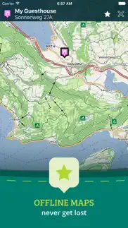
What is pocket earth pro app? • Detailed worldwide maps and travel guides • Topographic contour maps for the outdoors • Works completely offline even with GPS • Great when abroad or in the wilderness, NO data roaming charges • Online routing with offline Voice Guidance and much more!
« Reviews »
“I love this technology” – Natali Morris, Tech Reporter, NBC’s Today Show
Editor's Pick Best Offline Map App – thedigitaltrekker.com
“The best travel app in the world… Don’t leave home without it!” – bonvoyageurs.com
“Very impressive app with unmatched features.” – toptenreviews.com
« Maps »
• Beautiful Retina quality maps at a fraction of the size! The fastest and most beautiful offline maps on the App Store!
• Detailed and interactive worldwide maps! More than 100,000 places & completely free!
• Access your maps online and offline! Saves on data roaming costs!
• Personalize the maps to show the info you want!
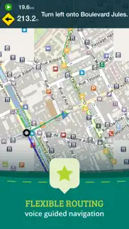
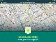
• Online Routing with voice guided turn by turn directions. Save your multi-stop itineraries for offline navigation!
• Online street address search and contacts integration!
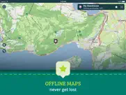
• Did we mention everything is offline? Works anywhere- cities, small towns, even in the middle of nowhere. Never any roaming charges. We dare you to try it!
« For the Traveler »
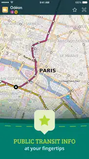
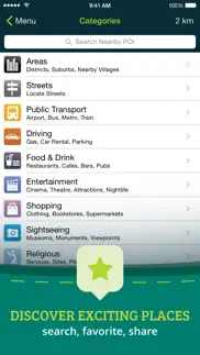
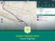
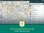
• Find out about thousands of interesting places - hotels, restaurants, bars, tourist sites, even get metro and public transit info!
• Our super wide area Nearby search is also super fast!
• Have all the travel info you need with more than 25,000 detailed Wikivoyage Travel Guides and more than 1 million Wikipedia articles in 7 languages! All offline of course!
• Customizable Pins and favorites groups! Add notes and mark and share favorite spots!
• Share maps links and your current location (SMS, Facebook, WhatsApp, Email, etc)!
« For the Adventurer »
• An in-app purchase option offers topographic maps. Get high performance, high accuracy 10m / 50ft contour display world-wide. The ONLY offline app that lets you download large areas, even entire countries! Contours are displayed on our existing maps for all Activities.
• Hiking and Cycling maps! Great for geocaching and getting off the track!
• GPS track recording lets you see what route you took! Great for hikes, cycling and off road! Never get lost again!
• Import/Export support for GPX and CSV files! Share with friends using PE Archives.
• Displays and lets you search for map coordinates (including DD, DDM, DMS, MGRS, UTM/UPS, GeoHash, and what3words)!
• Numerous GPS settings for your preferred configuration including compass and heading arrow or rotation, look ahead mode, accuracy and recording settings.
...and much more - so try it out!
« How's it Work? »
Just select the cities, regions, or even whole countries you want to download, and it will be available for offline use, complete with information on thousands of POIs (Points of Interest), travel guides and Wikipedia articles.
To do this we utilize community driven open data from a number of amazing projects. We use some magik to compress and package it in a format optimized for mobile devices. Pocket Earth then renders its beautiful vector maps on your device using our OpenGL ES based MagikMap technology.
To learn more about Pocket Earth or the community driven open data sources that we use, please visit our website.
Don’t forget this:
1. Using the GPS features of this app can significantly affect battery life. Only leave GPS enabled when you need to use it. Continued use of GPS running in the background can dramatically decrease battery life. Pocket Earth only uses GPS in the background for route navigation and gps track recording features.
2. This app uses data from the amazing community driven open mapping project called openstreetmap.org! Coverage detail may vary by region, please visit our website to check the map detail for your regions of interest.
3. Does not currently support all asian texts on the map (Chinese, Japanese, etc).
😍 Do you love Pocket Earth PRO app? Please share your friends!

Please wait! Pocket Earth PRO app comments loading...
Pocket Earth PRO 3.8.4 Tips, Tricks, Cheats and Rules
What do you think of the Pocket Earth PRO app? Can you share your complaints, experiences, or thoughts about the application with GeoMagik LLC and other users?
Pocket Earth PRO 3.8.4 Apps Screenshots & Images
Pocket Earth PRO iphone, ipad, apple watch and apple tv screenshot images, pictures.
| Language | English |
| Price | $5.99 |
| Adult Rating | 4+ years and older |
| Current Version | 3.8.4 |
| Play Store | com.geomagik.pocketearth |
| Compatibility | iOS 11.0 or later |
Pocket Earth PRO (Versiyon 3.8.4) Install & Download
The application Pocket Earth PRO was published in the category Navigation on 22 November 2011, Tuesday and was developed by GeoMagik LLC [Developer ID: 481679748]. This program file size is 33.35 MB. This app has been rated by 1,661 users and has a rating of 4.7 out of 5. Pocket Earth PRO - Navigation app posted on 19 April 2023, Wednesday current version is 3.8.4 and works well on iOS 11.0 and higher versions. Google Play ID: com.geomagik.pocketearth. Languages supported by the app:
CS NL EN FR DE RU ES Download & Install Now!| App Name | Score | Comments | Price |
| Pocket Earth Maps Reviews | 4.7 | 582 | Free |
Fixes issues with routing service.
| App Name | Released |
| Citi Bike | 21 May 2013 |
| OnX Backcountry Trail Maps GPS | 09 December 2020 |
| Parking.com - Find Parking Now | 07 August 2018 |
| Find my Phone - Family Locator | 08 January 2013 |
| Electrify America | 03 June 2019 |
Find on this site the customer service details of Pocket Earth PRO. Besides contact details, the page also offers a brief overview of the digital toy company.
| App Name | Released |
| Jacksonville Zoo - ZooMap | 25 October 2021 |
| Sun Seeker - Tracker, Surveyor | 04 October 2009 |
| Topo Maps | 26 March 2009 |
| GoSkyWatch Planetarium | 31 January 2019 |
| Tactical NAV | 14 February 2011 |
Discover how specific cryptocurrencies work — and get a bit of each crypto to try out for yourself. Coinbase is the easiest place to buy and sell cryptocurrency. Sign up and get started today.
| App Name | Released |
| 12 February 2019 | |
| Netflix | 01 April 2010 |
| Zoom Workplace | 15 August 2012 |
| Telegram Messenger | 14 August 2013 |
| ChatGPT | 18 May 2023 |
Looking for comprehensive training in Google Analytics 4? We've compiled the top paid and free GA4 courses available in 2024.
| App Name | Released |
| Incredibox | 27 March 2016 |
| Suika Game-Aladdin X | 06 March 2024 |
| The Wonder Weeks | 30 May 2012 |
| True Skate | 18 October 2012 |
| Bloons TD 5 | 15 November 2012 |
Each capsule is packed with pure, high-potency nootropic nutrients. No pointless additives. Just 100% natural brainpower. Third-party tested and validated by the Clean Label Project.
Adsterra is the most preferred ad network for those looking for an alternative to AdSense. Adsterra is the ideal choice for new sites with low daily traffic. In order to advertise on the site in Adsterra, like other ad networks, a certain traffic limit, domain age, etc. is required. There are no strict rules.
The easy, affordable way to create your professional portfolio website, store, blog & client galleries. No coding needed. Try free now.
Pocket Earth PRO Comments & Reviews 2024
We transfer money over €4 billion every month. We enable individual and business accounts to save 4 million Euros on bank transfer fees. Want to send free money abroad or transfer money abroad for free? Free international money transfer!
Pocket Earth. My only disappointment is lack of waterway names. Most ocean, sea, lakes and rivers are not named in map. Also, it takes multiple attempts to download requested maps; very time consuming!
Great for hiking.. There are so many features l use: - I download maps on my phone so I don’t need to use the cell phone network or the internet. - It shows more hiking trails than any other map app that I’ve used. - It shows bus and train routes for all the cities and counties I’ve traveled to. - I can add notes to my Favorite and can group them. You can also create a Favorite. - It shows elevation and speed (if you’re moving) even in airplane mode. - It sometimes displays house numbers in cities. I don’t use it for driving and it doesn’t give audio directions.
Okay for many uses, not for back roads. This is a great app for many applications. Travel on major roads, for example. However, for backroad users (hunters, fishermen, storm chasers) there is a major flaw: the minor roads disappear almost immediately when you zoom out. This makes it impossible to overview the road network of minor roads at a glance. There have been times I've been in the middle of nowhere and need to find a route 'out' to a major road. I can't easily do that, because when I zoom out, the road I'm on (and others I'm trying to find) simply disappear. It would be a simple fix: just add a setting that says to show minor roads at a wider variety of zoom levels. Until this is implemented, backroad users might want to steer clear.
The Best. This was one of the first vector based mapping software out there, and it’s still so vital to have. It’s one of the easiest to download huge areas right to your iPhone or iPad so you can take it with you anywhere. Never disappointed. Shows more details than others even when using the same OpenStreet Map. For example, power lines! Which can be very useful if your hiking in a rural spot. I’m glad to see some updates lately, and I could see some need for an interface update soon, but until then, this is simply the best offline vector map out there.
Pocket Earth Pro. Pocket Earth Pro is a great resource for those interested in traveling, adventures of those who just want to access maps for almost every location around the world. Almost any helpful information you can think of can be used for assistance. Whether individual travel guides for numerous locations, Wikipedia articles to provide information on locations, whether large maps of known and unknown areas that can be downloaded and accessed offline Pocket Earth has it. Most importantly the app is easy to navigate and use which can sometimes not be true of an application brimming with information. The side bar can be used to access a category or customize your personal settings. Pocket Earth is an application well worth a download whether the free or Pro version.
Excellent!. As a paramedic working in an remote, mountainous area I love this app. I used the offline maps constantly and have used it for coordinates when requesting a helicopter with perfect accuracy! You won’t regret getting this app!
Vertical Route Planner/Tracker, etc.. I’ve been using this app for several years now and I’m very happy to see that it continues to be updated. Don’t be lazy. Take time to understand the user interface. It’s well thought out. If you do you will find Pocket Earth great for planning travels, recording tracks and discovering places of interest at way points. Finally, you can download maps that cover your route even when you lack internet.
Great Resource!. I bought this so I would have maps when I had no cell service. We’ve used this in Europe and for some Caribbean cruises. Just download the maps you need before you leave. I also appreciate the POI data which is included.
Great world wide app. Have used this on my travels around the world. Great maps for cities and countryside and used it in almost 50 countries. Will not go anywhere without it.
Killer App!. I’ve had this app for years, but I just recently started using it. Best mapping app I’ve ever used. The maps are beautiful, easy to see and read. I love it
A must-have for world travel. A phenomenal tool for travel of all sorts. I’ve used this primarily for navigating the bush in sub-Saharan Africa, but have found it useful for travel most anywhere, especially when wanting to quickly share information and locations with other people.
Great Offline Maps. Great to use on older phones that no longer have cellular service. Load the app, download the maps and just use the internal gps with the map software. For $5 you can download the topographical maps, if you know how to read them. I’ve always just wanted mapping software that didn’t rely on having data available. Now I can just download while on WiFi and go. If you are running low on memory, you can just download the states you are in or visiting individually. From time to time I have noticed that maps are deleted when the app is updated. I did have to reload maps, but if I was already out and about I would just download the state and I can always restore my purchase of the topo maps and be on my way. Have fun, enjoy and get out and go explore.
Love the app.. but... I have used this app for years and I really like it.. however, I recently found an issue trying to find an offline map to download, emailed the developer 3 times over the course of 1.5 months and there has simply been no response. So I’m about to leave on my vacation and I’ll be map-less.. guess I’ll be trying google maps offline for this trip.
Life Saver. I enjoy using this app very much especially since one can download the local map. To us this meant that we didn’t need to have an Internet connection as we traveled around our destination city, Toulouse.
Me. I bought this app to enable me to use tracks for an upcoming cycling trip in Slovenia. The ease with which I was able to load the necessary map and then the gpx tracks made available to me was remarkable. I look forward to using the navigation features on the trip.
Fantastic trail finding. I like bicycling in the backroads of the world. In 25 countries I have used downloaded PocketEarth maps to pick my way through paths, urban and rural, on my bicycle. I have crossed skinny dams, gone alongside the Black Sea on farm trails, found my way through the Carpathian Mountains on skinny roads with River fords, and gone through odd corners of wild land in cities. Almost universally without fail. The only exception is that in the USA the “private road” data is sometimes inaccurate, and I have had to turn back and retrace my steps. 5 stars! I would give it more if I could. 6? 7? 10? Maybe 12!!!
Decent Maps. The maps are good. The topography layer is adequate and since no one else really offers any decent vector topography these are the best available. The UI isn’t my favorite but whatever. I just use it for basemaps because I have other apps for the other things this app does. Wish I could hide unused UI elements.
Most used app?. Possibly. Pretty simple to use, easy to measure distance , put markers on. Ability to download maps helps. Not always complete with trails and/or landmarks but good enough. Helps you not to lose your way and to plan your routes. I’ve used it all over the world, very helpful and functional.
Excellent tool. I’m continually impressed with the significant detail and depth of information in the maps. Extremely useful. Certainly beats Google offline maps. The app has lots of useful features. I often use the tracking tool.
Great app, woefully out of date maps. When I first found this app, they promised to update the data every couple weeks. A few years later and I’ve found that updates seem to come 6mo apart or worse. Given that the maps are derived from OSM, the maps are being improved *daily*. I just looked at an area that I know was updated months ago with more detail, yet even after updating the data is missing. I’ve contacted the developer in the past and when they bothered to respond they gave promises of updates that then failed to materialize. Very disappointed.
Great app for outdoor!. Amazing app! Way to customize the route such as avoid hill in cycling is something never seen in other apps! At any time any location you can see your moving speed and altitude. So many features am so excited about. Real masterpiece if you are all for outdoor activities! Better than any other popular and heavily advertised apps out there! Don’t get blown away by so many options initially. Once you get used to it, it’s hard to find anything else that can compete with this one!
Works like a champ. LOVE the fact that it works offline. I put it on my trusty iPod and not needing wifi or internet makes it an indispensable asset when I travel to remote areas. Sometimes I disagree with its choices for fastest or shortest routes, but on the other hand that frequently reveals alternate routes I can use when my preferred ones are jammed with traffic. I wish for the option to enter street intersections as a destination. Sometimes you don't have an address but you otherwise know exactly where you'd like to go. If its possible to do so and I missed it, my apologies. :)
Unable to restore Topo map purchase. This used to be a great app, but now it’s impossible to restore the Topographical information that I purchased. The developer does not respond and there is an error each time I try to restore my purchases or even buy it again. Needs to be fixed!
Fav maps! Offline, topo, accurate, configurable. Pocket Earth is awesome for several reasons: 1) Offline maps. This app was my go-to choice for a year abroad where I often would not have internet. It was amazing to download *the entire country* in one easy step (and it didn't even take up that much space!) 2) Topographic maps. Great for backpacking & cross-country skiing. 3) Configurable points of interest. I can enable banks & tourist spots while disabling other things when traveling, or enabling Wikipedia locations(!) in an area I'm curious about. 4) Easy saving & copy-pasting of recorded GPS tracks and coordinates (in many different formats!) 5) Most accurate running tracker I've used! This is an unexpected and random benefit, but it really does do a better job tracking my runs than the many other running-specific apps I tried (all other running apps had pretty bad "jitter"). Great app, thank you! :)
Good App. Good maps and kept current. Reason for 4 stars is the updating process is very tedious. To update the maps you have, you must actually go to the country and update that location’s maps. Must keep the app open to do so. Best to update the maps overnight, as it’s a pain in the neck during waking hours.
Super useful especially when you have to go off the grid. I use this for finding hiking trails during the day then a place to park when going out at night. I've not found a better offline mapping solution and I consult it constantly. All the points of interest you could hope for and travel guides to boot.
Sync has stopped working. I’ve always loved this app for its offline trail and navigation support. But saved routes and points of interest are no longer syncing. I can’t compare notes of recent hikes between my devices or plan something on my iPad and then leave it behind and use only my phone or watch. I’m also scared to upgrade my phone, not knowing if my favorites will be carried over. There’s no way to contact the developer or get support, so I have multiple backups of my Pocket Earth history and am looking for a replacement app.
I have used this app all over the world and it is nothing short of awesome. Indispensable.. This is a must-have app when traveling to rural areas, small towns and out of the way places. Extremely detailed offline data base makes navigating a cinch.
So Useful. Download the maps where you’re going and you are set. No need for a data connection, and pretty simple and intuitive. I use it every time I travel, drop pins at places of interest, or even where I park my car. Five stars!
Pay & pay & pay again. When it works, it works great. It can show your location on a map even when there is no service, using the built-in GPS, provided that the relevant map has been previously downloaded. The problem with this app is that it does not respect family sharing, and if one gets a new phone, ownership of the app is lost. Restore purchases does not work with this app. If you get this app, you will need to re-purchase it for no discernible reason.
It just works!. Love this off-line map program for international travel (not burning up data) and hiking. Many times I will hike in areas without cell signal and need Pocket Earth’s maps. Also great for finding trails and for marking my route so I know how to get back. Great App!
Pastes from Clipboard when Run, No Offline Routing. Why does it paste from the clipboard when launched? That’s a big security issue. Offline routing is no longer possible — some areas have no cell service. This defeats the purpose of offline maps which was a great safety feature. This was one of my favorite apps for being able to download maps for offline use.
Great app. We used Pocket Earth Pro to navigate a 2500 km cycle trip around France. It was indispensable. We used it to select cycle paths and low traffic roads between destinations. It also helped us to find food and lodgings near our routes. Highly recommend this app.
Highly recommend. Sandy and I kayak oftentimes way off grid in complex waterways. The tracking feature not only helps with navigation, but also helps us keep a record of all our expeditions. We tell many people about the app wherever we go. Thank you pocket earth.
Best Nav App. I travel a lot around the world and use this app everywhere I go. At new places, I drop pins first at the hotel, the work site, then all the restaraunts, convenient stores and other points of interest. When I walk around, I set a track to the pins so I know which direction to walk. I can get coordinates from Google Maps and use it to drop pins too.
The best. Absolutely the most top-notch, accurate and user-friendly navigational app out there. I have travelled and backpacked through 65 countries and Pocket Earth has steered me around the world. From traversing the bustling souks of Marrakesh to wondering the colonial streets of Cartagena Pocket Earth was there for me. The app showed restaurants, roads, stairs, local passageways that would not have shown up in other competitor navigational apps. Definitely better than Google Maps. The highly customizable nature of the app allows you to drop a pin for points of interest and also mark things down for later exploration. Two of the best features are the location tracker that tracks where you are without data. Pocket Earth is also able to calculate the distance between two points; allowing me to estimate how far a place of interest is. The vast amount of WikiTravel stored on the app is amazing. Without using online data I am able to read about an upcoming country. The information on local bus and train routes makes this app THE BEST in the industry. I can go wherever I want and not be afraid of getting lost anymore. If you’re still contemplating, download it now. You won’t regret it.
Almost Perfect App. I have been using the Pocket Earth for almost 9 years and have enjoyed its use and improvements over time, including more detailed information regarding services, businesses, etc on the map. However I continue to experience sporadic problems with syncing between devices. Just today I created five new favorites and put them in a newly created Group on my iPhone and they have not shown up on my iPad over 8 hours later. I have the sync feature turned on on both devices. So not sure if this is a server issue or what, but it is frustrating. This has happened in the past while a actually traveling, which is even more frustrating. Would appreciate hearing if other have this issue.
Map. Please bring offline routing. That would make this app stand out from all the others.
Finally offline topo maps that work. This app worked great at Rocky Mountain National Park when trying to follow the trail buried 6 feet underneath me in snow. Offline with no service. Thank you! Ps regular navigation works great too.
My go-to travel planning tool. I like to plan my trips well, and that means being able to find and mark locations on map and plan routes. I have found no better tool for this. Takes a little work to figure out how best to use - but worth the investment. My top desires for future updates is to be able to turn off all Wikipedia icons and even better ability to turn off all icons other than the ones saved - I like to print off maps that show my locations of interest but map gets too cluttered with unwanted icons.
Perfect. It just work and being in areas where the is little to no reception half the time I don’t have to worry about a silly data connection.
Fantastic offline/online app. Highly recommend this app, which I have been using for about 5 years or more. Really good for travel, especially if you will be going somewhere where you do not have an internet connection. You can download and save maps for wherever you will be in the world. I have even used it on flights where I can look out the window and see these beautiful islands, but I don’t know exactly where I am or the islands are. With this I can find out and possible visit them some day. Love this app! Thank you to the developers. Get it.
Pocket Earth Pro. I wrote this last year and have used Pocket Earth Pro even more since then. An essential travel tool which only gets better. “Fantastic app for any traveller. Offline maps including location based wiki articles and tons of layers to show or not. Very smooth scrolling in/out. Import POI's or add within the app - and create routes for offline,voice guided driving. Even shows one-way streets in tiny Spanish towns! I never leave home without it.”
Love this App.. Have used for many years and around the world. Love the downloadable maps for offline use. Great for hiking and tracking in the back country or the city. Try it!
Maps out of date; customer support nil. I generally like this app but its maps are not refreshed in any regularity. I understand that this app pulls from other map sources - but those sources have been updated months ago and they are still not reflected in this app. Emails to the developers fall into a black hole. How about some support? This app is invaluable for those who want to travel off the grid but with bad data it is a risky proposition.
So useful, really excellent!. Am so impressed with PocketEarth from 8 years of using it all over the world. It keeps my favorite bars, restaurants and places to stay available for the future but even mundane things like ATMs and such. I can’t say enough good things about this app!
Love it - and I'm a map geek. I LOVE this map. I first used it many years ago with my iTouch and now have the Pro version on my iPhone. You can navigate with iPhone even if you have no cell coverage; the GPS still works. I always pre-download maps when I travel. I can then navigate off line, which saves data fees as well as battery. The ability to switch which maps are downloaded is great, and very easy. I can for example download British Columbia topo maps for a backcountry trip; then later remove it before downloading Italy for my next trip. The level of detail and the number of "points of interest" is fantastic! I’ve even used it to navigate the Paris metro system! I d like to see more icon choices for “favorites” I save. A way to indicate a trailhead, or a picture of a car come to mind. Another update I’d like to see is that I’d like to be able to search for routes or tracks that are “Nearby”. The only way to find them currently is to search “Groups & Filters” by name date or user. Since I have dozens if not hundreds of Tracks and Routes, this is cumbersome. I usually don’t remember the name or date, and the user is always me, so I must scroll through the entire list.
Very good app. This app is one of the first apps I downloaded when I got my iPad. It has been extremely useful when traveling. It has got my buddies and I to are destination several times when all their cell phones could not, and I was only using the offline maps. The transportation info is always accurate (train route numbers, bus numbers, etc,) and will usually show your hotel. I am not a tech guy so I only gave it 4 stars because it is complex, otherwise I would have given it 5 stars. Any young person can use with no problem I’m sure. I was never sorry I got this app. Stevo
Great for cycle touring. Pocket Earth is my go to offline map when I an cycle touring. I’ve cycle toured across several continents including Asia and South America and always found it to be reliable. I especially appreciate the clear contour presentation, and the amenities and places to stay at the remote settlements where I end my day.
Great app!. I’ve been using Pocket Earth for years. It’s one of the best apps I have. The offline map feature is great; you can download and don’t need cell service when you’re out.
Did you know that you can earn 25 USD from our site just by registering? Get $25 for free by joining Payoneer!
Highly detailed maps. You never know when you might find yourself without the network so you really should get this now while you can. Might save you in a sticky situation!
Zm. Great app but need to improve downloading maps - full download every update not that good.
Great backup navigation app.. This app shows information other map apps do not. It’s saved me a few times.
Bring back a smaller GPS Arrow. I would give it 20 stars if I could as it is a fantastic off-line app, EXCEPT: The GPS arrow is now way too big and grossly oversize and hence gives a hugely inaccurate reading as to one's exact location. I have the map accuracy set to 10m but the GPS arrow is about 1km in size in relation to the scale of the map, and hence the arrow not only blocks your exact location but makes it hard to determine exactly where you are with any real accuracy. Furthermore, the absurdly oversize GPS arrow also distorts the distance to your destination, because the size of the arrow means the arrow gets to the destination at least a kilometre before you actually get there. The ridiculously large arrow makes no sense in a visual way either: it has probably been made huge so it can easily be seen, say in direct sunlight, but that reason is illogical because the map detail is so light and printing so small in relation to the giant GPS arrow that all you can see is the GPS arrow and not the map. Geez, put the GPS arrow back to a proper scale and context and I will give you a 100 stars!
Perfect-Map-App. In one broken word.. This has by far been one of the most valuable apps I’ve ever bought for travelling.. From downloading whole country maps (AND Wikipedia databases for that country) to my iPhone - to being able to place my own POI markers for personal favourites - to then being able to export all of these POI’s to a file I can then share with friends - to then have access to basically the whole of Wikipedia for any city I visit.. before finally arriving at the ability to filter map-generated Points Of Interest better than any Google Maps/Apple Maps client I’ve ever seen.. Making it so simple to find everything I need, from Hotels to places to eat and things to see.. There’s just so many reasons to buy the app. Perfect.
Awesome app, works very well. Hi Love this app, have been using it for 2 years now and have had no issues. Uploading GPX files works like a charm and I never felt that it drains phone battery too much.
It’s ok, but could be better. App helps in many cases, but the navigation around the app is often confusing. It’d benefit from a UI overhaul. Where do I get my recorded tracks from? How do I even record a track? What is my current accuracy? Etc. These things make you wonder if the developer(s) has/have used the app in a real application at all. I paid the $8 for the topography upgrade, but I don’t get topo maps for all the areas. In fact, many areas seem to just use OSM.
ByeBye Yelp! Foursquare CityMaps2Go TripAdvisor….. Well not quite, but after much app searching and stuffing around I have decided that PocketEarth is the way to go. Yelp and the likes are good for looking up places but as the central repository for all good things nearby, to do or to be done or how to get to them PocketEarth is the way to go. The reasons I choose PocketEarth: - Maps don’t get cut off at city limits like a lot of others - Good place to mark the places you want to remember - Groups - I have a group of “Bucket List” for places on that for example - Privacy - you don’t have to worry about everything getting broadcast - GPS Co-ordinates, really useful off-road - Subway/Metro lines etc. It’s a little technical, you have to play with it to really understand it but after many many hours on all the travel apps it really is very very good. You can add your own places - my only request to PocketEarth - when you add a location it should get shared back to the map source somehow. Please pay them for the full version, it’s worth it and I have no affiliations.
Great app for trail trekking. As a newbie, pocket earth is a great app to start with in Australia to learn about gpx files, trails, how gps can support map reading etc. i know more experienced trekking folks who use it. The Pro version and Topo maps well worth it, a great app.
Best App Ever, especially offline maps in Japanda!. I just got back from Japan and this app rocked! Downloaded my maps at the airport then went to the snow resort and used the offline maps each day. Then once I was back in Tokyo it was a life saver for navigating all the tiny alleyways. I Also used it to find some hidden gems like Whiskey bars and crazy restaurants you just never know existed. Well done guys love this app! Original: I love this app. It's gold. I've downloaded all the maps for Australia. Easy, quick. Now I can turn data off and not worry about expensive data roaming or finding wifi. It even works in airplane mode (but not the gps). I've been using it to keep track of my secret surf spots up and down the east coast but also more for great cafés I want to find again. Super excited to see what features are coming next!
Disappointed. On first using Pocket Earth I was very impressed but since May 2018 tracks have stopped recording efficiently and the app closes unexpectedly. I have tried contacting the providers and had only 1 response with no resolution to my problems.
Great mapping tool. Good offline map with tracks, topography (additional cost, though) and points of interests (more could be added). It would be nice it the map showed toilets and free/ cheap campsites.
Great but some missing tracks. The everard circuit has tracks not on map. The Great South Wwst Track also has missing tracks on pocket earth. How can I add my mappings to pocket earth?
Best Travel Companion. Pocket Earth is a great tool for travelling for leisure or work. I love to pre- plan a bike tour and then simply follow it on my phone. It especially makes it easy to traverse built up areas without getting lost. A game changer for bike touring. Happy days 😃😃🙏🙏
Just get it!. I have used this across countless countries. It is perhaps the single most useful app I have ever purchased. The map data it uses often has more detail than google maps, especially for hiking. The topographic add-in is essential and brilliant if you like going into the outdoors.
Great for Caravan trip. Using it to plan our WA caravan trip for 2 months, ideal for this.
One of the best. This app has more detail on it’s maps than some governments do on their maps. Easy to use with loads of features. I just love it.
Greatest app for planning and navigating holidays. Used this app all over the world. Excellent information. Always accurate. Found our way across the Yorkshire Dales in thick fog.
Detailed, easy to use and quick. I travel a lot and always use Pocket Earth now. I used to use Triposo but downloads took ages and so did zooming. The software behind Pocket Earth seems much cleverer and is not bloated.
Awesome. Use it in all of my trips. Best for walk exploring
Best offline maps. I've tried all the offline map apps but I've consistently come back to pocket earth. It's been a great resource while traveling (where this map really shines) as it's helped us find so many trails that we would have never found even places like Thailand. You can plan a journey by dropping place makers and get around in any city town without a connection. If you're in backcountry/off track it doesn't replace a real topo map but it's an amazing resource for planning and discovering. I've only used the app for offline (it's not google maps) and you do need to download some hefty files but 2.3gb gets you all of the topographic maps/trails/roads/POI for a continent like Australia to use offline. Insane really.
Great portable maps. Pocket Earth is a wonderful app for those that travel without a local SIM card. By downloading the maps of whichever country you are visiting onto your tablet of phone you will have access to them at anytime. Save the places that you are interested in visiting to find them quickly when you are there. I have used it in Peru, Greece, USA and so many other places and it always works a treat. The only thing that it lacks is the ability to give you step by step instructions when you are off line unless you have prepared them previously. I use this app all the time.
Must have travel app. I've used this app for offline maps while traveling through Thailand, Europe, the UK, Tonga & India - it's been indispensable. Being able to see which street you are walking down in Venice and see the pin of your hotel saved a stack of time and frustration. Public transport routes across Amsterdam and knowing which stop you are coming up to after just arriving in the city made it so easy to get around. Even in Tonga, remote island location, maps were up to date and GPS while whale watching meant I could save the info for later tagging GoPro video footage.
One of the BEST except for route planning. This is a stand-out app in its class. I am a hiker and I use it all the time. It comes into its own when you are doing recce's and want to track where you have been. The topographic overlays are great. And when I go to remote areas I really like the feature that allows me to download maps first. And the GPX export is nice. BUT route planning had some serious issues. It refuses to recognise walking tracks even when 'walking' is selected as the transport mode - when you add a waypoint right in the middle of the track it tries to back-track down roads to find an alternate to that point - my 14km day walked turned into 29km. I mapped out a trek that was a complex figure-of-eight route using roads and walking tracks and I ended up with routes going everywhere and it became a useless mess. Also, the map failed to load several times and I had to restart the app. The developers either need to fix this, or allow you add numbered waypoints and just draw straight route lines between them so you can see the order in which to tackle the route, and you can work it out visually from there. So, nice work, but PLEASE fix the route planning feature - I don't care if the calculated routes are straight lines as a first step :-) Hope that input is useful.
Offline functions. Need to be able to plan a route off line
Voice navigation offline on the autobahn!!!. Just got back from a trip to Germany. Some friends introduced me to this app because it works offline and unlike google, it doesn’t send your location to “the cloud”. I found it much quicker and cheaper than using apple maps and much better for storing my favourite locations and cafes for my next trip. I was even able to use Pocket Earth on the autobahn! They added a voice navigation feature while I was there, it’s great! Developers seem to always be adding new stuff. 5 stars.
Absolute must for offline use. If you are going overseas and don't want to get killed with data roaming charges, download all the maps you'll need while you have wifi access and then when you're out and about you can get where you want to go without breaking the bank balance. Would like easier / more intuitive access to explanations of what the various functions are and how to access them. Still trying to work out how to delete a pin! All in all though, an excellent app for travellers.
Great app with offline maps and detail. Highly recommended! You can save maps for use offline so you never need to worry about WiFi or expensive data. You can download only the maps you need and delete them whenever you need to save space. The detail is also better than google maps and there are maps for areas that Google don’t have. Worth every cent!
Most valuable app I have ever downloaded!!. I have used this app in over 25 countries in Asia, North America, Australia & South America. It has never once let me down on location or detail. The offline feature means I don't need wifi or local SIM card with data. I swear it has saved me hundreds of dollars in taxi fares because I know things are within walking distance or the app shows a bus/train route. Love love love this app and I recommend this to nearly every other backpacker I come across. Most valuable app I have ever purchased.
Brilliant. It’s a fantastically useful addition to the various map apps that I have. I use the route tracking facility often—it’s great for sending to friends so that they can see your route in Google Earth. But gosh, how I wish I could find out how to remove all the categories of POIs that I’m not interested in. Sometimes my maps are covered with so many POI symbols it’s hard to see the map!
Not bad but. Every time you zoom in say to see attack name the track name is , are been smaller really defeats the purpose of zooming in and therefore makes maps super hard to read
Best hiking gps app, period. I’ve tried and used a lot of hiking gps app. I used to be a big fan of MotionX-gps but the developer seems to have discontinued support as it is now longer in the app store. Since I wasnt really satisfied with the other hiking gps apps I already own, I looked around for a replacement. Then I found Pocket Earth Pro! Wow! Just as intuitive an interface as Motion X but more up to date detailed informative free maps. So I moved all my tracks and way points over and I am one happy camper! Literally! Everything is more up to date regarding iOS. Even streets are named. Wikipedia links to POIs. A fabulous upgrade for me. Highly highly recommended! 5 stars!
Pocket Earth. Great app. Crappy support
Feedback. Great app really good when there is no signal for telephone Text on roads could be larger when zooming in for older folks. Otherwise pretty good. Thanks
Excellent. Especially the public transport routes
GREAT CAMPING TOOL. I found Pocket Earth Pro several years ago and since then I have hundreds and hundreds of Australian camping locations ‘saved’ along with P.O.I (points of interest) that includes bakeries, Bunnings (Australian Hardware Store chain), etc. I attach comment on camp sites and even photos taken from above by Google Earth. To get these photos I do a cut and paste from a relative P.E.Pro camp site of its GPS Coordinates and paste them into Google Earth and then zoom in for a close look at the chosen camp site. I then take a screen shot of the camp site and paste it into P.E.Pro. Another good point is that if you zoom into a town you will see the names of all the roads and streets. I rate Pocket Earth Pro 10/10
Great for cycle touring. Our great standby while planning 4 long cycle trips in France, 2013, 2015, 2017, 2019. Wished we'd had it in 2012! Also used extensively at home in Australia. Fantastic that you can have all your maps downloaded and be independent of wifi connections. We have a cellular version of the iPad, but no SIM - we rely on the GPS capacity + the downloaded maps to locate ourselves whenever in doubt. Also worth adding that it's just as useful for car touring & I like it's not another Google product!
Loved it at First - Now not so sure anymore. When I used it at first it was great ( end 2013 ) , now end 2016 not so sure. Every upgrade forced me to download all offline maps all over again. As I’m planning a long bike journey trough Europe this has cost me a lot of time / bandwidth. Why not keep data and software better separated like iTunes itself. Imagine I had to download all music every time iTunes upgrades. No excuse guys … you made great app , just fix this download the maps all over issue please. For now only 4 stars sorry
Good features- hard to use properly. I love the detail and being able to store all of Australia so I’m ready anywhere. It is a pain to navigate through the features. You need to be in a map to select the home menu. I haven’t read all of the help but enough to see that you need a lot of practice and trial and error to switch between recording tracks , titling, deleting , getting navigation going, hiding previous tracks from your map etc eyc
Good but. Currently won’t geolocate, even though all settings seem on, GPS location, phone data , so forth. Worked before last update. Finally fixed problem, app must have glitched settings on update, change location to ‘always’, and then back to ‘only while using’, now good.....
Amazing app. Offline mode is a lifesaver for those with little or no mobile data. But in addition I would prefer an option to use the internet for routes only and prompt the user if extra map data is needed. The app automatically starts downloading map data in online mode which is annoying if your using mobile data and would rather have waited until you had access to a WIFI hotspot. But this can be avoided by downloading countries ahead of time. Using the app to get from A to B was not clear at first, you need to press the route button twice to enter the Start and End of the route, then you press X in the top right to exit the route feature. Their website guides don't do a good job of explaining this, there are no step by step instructions. I just had to figure it out. I've now been using this app for a week and can say with confidence this is the best offline map app out there and I will be using it for years to come.
Great app. Co ordinates numbers could be a bit larger but otherwise a great app.
Excellent for motorbike adventures. I regularly go exploring off-road routes and tracks and this app allows me to pre plan the route and then record the actual trip for later use in google earth. It's very simple to use and the offline content is simple yet comprehensive. Great work guys!!!
The best for hiking adventures. Compared to other similar apps I have downloaded, this is the best app you can get for a small one-off fee. It makes route planning a breeze, sharing/exporting waypoint details easy and is solid as an offline mapping tool on the trail.
Very high-quality offline maps app. I've tried a number of offline map apps for travelling and this one is the clear winner. Not only are the maps more detailed and smaller downloads overall, but the whole user interface experience is intuitive and responsive. All map downloads are asynchronous, meaning you can queue many of them up at once and continue using the app as normal. The ability to get online directions and save them for offline use also puts this app a cut above the competition. Highly recommended.
Navigation bar failure. The maps are excellent and the tracking of your location is excellent but if you lose the navigation bar it is a Herculean effort to get it back again. If only it was straight forward and easy to find. Also, when trying to get it back you end up adding new routes and generally getting very frustrated .
Brilliant app. One of my favourite apps . Works great offline while overseas so can save on data roaming fees. Have been using it locally as have found extensive information about my area that I didn't know existed particularly cycling routes and tracks . The cons : POIS makes maps too cluttered . I wish there was a option to allow your personal preference of multiple points of interest and remove all the clutter. When there are so many POIS it makes it very difficult to see the map well , particularly when your in a city.
Was good, now continues to drop out. This was my “go to” map and GPS program because of the offline capability and tracking. Unfortunately since the last update (2 months ago Sep 2022) the app continually drops out/shuts down and stops tracking. 😫😩😤😠🤬 This is extremely frustrating for a previously outstanding program! Hence my giving it only 2 stars Please, please please fix it! Having an offline route calculator would be good too
Best offline map app. Fantastic app for traveling Overseas. It not only shows where the bus, tram & train stops are, it also shows the bus/tram number that frequents the stop and where they go and the path they take.
Value for money with room for improvements. This is still the best offline IOS map program I know, however it is no match for Google maps search capabilities. It's a shame that in time-poor situations I prefer switching to Google maps rather than fiddling with Pocket Earth Pro online. Car navigators accomplish this task easily with addresses, POIs. It would be an idea to offer map downloading options with or without offline search, where the searchable version would obviously occupy mor space. Pros - offline maps occupy reasonably small disk space - offline tracking is very good - being able to switch any time among online/lan/offline, independently from iPad settings - map downloading options of city only or country Cons - even the online recorded route's voice guidance stops working if you deviate from the route. This makes a poor quality offline voice guidance: the voice instruction to return to the route is useless - unable to search anything offline, even on a downloaded map, is a significant limitation
Imagine you at your best. All the time. Picture yourself at your sharpest and most productive. Your most alert and focused. Your most lucid, creative and confident. At work. At play. In every area of your life. Add Mind Lab Pro® v4.0 to your daily routine and uncap your true potential. Buy Now!
Vraiment bien. Très complet
Best Place to visit at Chitwan,Nepal on the bank of Narayani River. Thumbs Up with Attraction Visit Nepal
Excellent app, worried about future support. I’ve been using this app for many years now and this is absolutely my first go-to app for travel. I have the terrain as well and have used it extensively for anything - hiking, biking, car travel, overlanding or just reference. I keep a backup copy of all my favourite places, locations, routes etc. Incl. my notes on them, which are very easy to import/export. I’m a bit worried that the support for the app will disappear, like it happened with way too many apps I used to like and honestly I see no worthy replacement... But while it’s working - highly recommended!
PocketEarth Pro. I'm just starting to use PE but so far I can say it's very intuitive, user-friendly and includes many useful features.Best app!
Useful app. One of the best map apps in offline mode
Best App for travelling. Just got back from a trip to SE Asia. This app is so awesome. Just download the countries you are going to. I recommend downloading the wiki packages for the countries as well. Lots of info. Don't need data or wifi even when its tracking your location. I used it constantly. 5/5 would recommend.
A must have map app. this app saved me many times with its offline gps, and the in app list of all local hotels/restaurants etc. are invaluable. I've been using this app frequently since 2013 through 7 different countries and swear by its functionality. I've only ever encountered one issue with it and it was that it doesn't have fully detailed alleyway systems in Vietnam. I can recommend this app to any backpacker as one of their most valuable tools, to any traveller as a helpful guide when needed; and to any expats living in foreign countries to use the tag feature to easily find your way around new cities.
Highly recommended for traveller without continuous data access. I wanted a simple way to preload detailed maps onto an ipad and use it on a trip without having to incur wireless costs. From my tests it looks like once you explore a city (zoom in) it auto downloads detailed maps. I've turned off wireless access and browsed in detail on a number of cities. Those that were downloaded already worked fine. Those that weren't gave an download error message when I tried to zoom in. Like I said this is exactly what I would expect it to do. I'm going to try loading some pois as an experiment but this is bonus functions. UPDATE: currently sitting in Paris, and very happy with this app. Has been terrific for this European vacation. Shows bus stops, subway stops and monument names for cities we've visited. Used many times to find out where we were. Used many times to find out if we were going in the right direction. Has extensive wiki articles on many (not all) of the major sites. Have shown it to others who can't believe this isn't an online app. (i have no data plan here - just preloaded the cities we visit, and occasional stops at wifi zones). I even used it to look up one restaurant we were trying to find in London (Vapiano). It happened to be one of the ones that was listed, so we could just walk to it without a detour to a wifi hotspot (like Starbucks) to google it. FYI, I found i also need to install a metro and bus route planner that works offline. I highly recommend this app for anyone taking a European vacation who will not have a data plan. Thanks to the team who put this together! This is a great app. Excellent work. UPDATE 2017-07 I still use this map regularly and for some use cases. First, anywhere I don't have data access, which can be out of country or back country. Second, it has hiking and cycling trails and at times has made hiking route selection much easier.
Lost syncing between devices. This is a very useful mapping application and I have been using it for several years especially for hiking. It has reassured us many times in foreign countries that we were on the right trail. I noticed recently that it no longer seems to sync my favourites and tracks between my Apple devices. Maybe with IOS 13 and no new Pocket Earth App update this capability has been lost. I use the app on my phone as well as IPads. I have SIM card capabilities on my IPads and use them to route find. I did find a workaround for the missing syncing by exporting the information, emailing the file to myself and then importing it on the second device. This is an awkward way of syncing but does work. I put my device on airplane mode to reduce battery use when I am route finding in the back country. I find that the device continues to search for cel towers and uses much more battery power when not in airplane mode. Other than the syncing problem, I am pleased with this App.
Great maps. The best thing about these maps is that it not only has the trails but also has the logging roads which help put your location into way better perspective. The topographic lines are an excellent add on so I know what I'm in for. I would highly recommend this app.
Great App. its a big help for navigation...
Impossible to navigate. Cannot pull up maps that I saved! Especially dangerous when you are pulled up on the shoulder of a major highway!
Works well!. Works well and does the job, even from kilometres in the sky on an aeroplane!
Superbe et facile a utiliser. Best ever , anywhere on the planet . Perfect.
Keeps getting better. I'm a map junkie; don't know why, I just love maps and mapping and this is my favorite iOS mapping app by far. If you like to hike, bike, travel or generally go places without good cellular coverage, you'll quickly realize how valuable it is to have maps stored locally on your device.
Better then all else!. Even though there's much to learn before using it at its full potential, the application works wonders. For hiking trips in the wild, or just trying to find viewpoints it's an amazing app. Plus, compared to all other hiking apps (AllTrails) around, this one is free and had always up to date maps due to it being synced With OSM. You can download offline maps without paying a monthly subscription. I use it everytime I'm going on a hike. Definitely a top 5 travel app.
Gréât app. One of the best off-line map apps. The maps are not all up to date, but the app still has many good features.
Great App!. Great detail, excellent offline features, GPS - very useful exploring Montenegro and the Balkans.
Fantastic Map App!. My wife and both love this offline mapping software! Very easy to use, many useful features. Wonderful to know that even if you lose Internet connectivity you always can determine where you are. Cannot give it enough praise!
Outstanding app. This app does ***everything*** it's designed for RIGHT, absolutely RIGHT. It is well written, has a clear, intuitive interface and performs REALLY well. No useless bells, no interface "innovations" to distort the framework of iOS design principles. The apps of this quality make the Apple ecosystem a pleasure to use.
Super. Doesn’t show my position anymore on my new ipad. It Cannot follow my position. Even if all the settings are ok it doesn’t work. Ironically it works on my iphone 6 with no wifi or cellular connection. What is wrong????????
one of my most useful apps. Huge fan. Going to Paris? Maui? download to phone, cached maps. now you have Google map level of details, no roaming and even includes Wikipedia site-seeing info. Maps don’t cost anything. Also does, extra cost, Topo hiking maps, quite good, though not as good as 15000 scale paper ones.
This the one if you like the wild. You wil never get lost, it is full of features very accessible. You can even as an real offline GPS, worth every pennies. Thanks
WDC. Love this app. By far the easiest to read and navigate on. Wouldn’t trade it for any other. Covers all the bases. Used on the Francigena. Perfect!
Application géniale. Un must pour les voyageurs. Je prépare un voyage en Europe et cette application me permet de tracer des itinéraires, de cibler des points d'intérêts, de mesurer les distances, d'inscrire des notes pour chacune des destinations, bref tout ce dont j'avais besoin. Il ne reste qu'à savoir si sur place tout fonctionnera comme prévu. Pour l'instant, je suis grandement impressionné de tout ce que l'on peut faire. En plus, les cartes sont très facilement lisibles et agréables à consulter.
Fabulous app. So much detail when it comes to trails. I tell all my friends and strangers about it.
Fantastic tool!. Still trying to learn all the features
Very useful resource.. The degree of zooming in is amazing. The offline feature is important to me.
#1. Saved our bacon several times !! Thanks
Absolutely the best. We travel all around the world, from cities to very remote regions. I've tried many apps for mapping, tracking, and orientation, and none of them come close to Pocket Earth for detail. The offline maps are life-savers; the level of detail amazing. The UI is complex and sometimes a bit confusing, but that's part of the price for the sheer mass of functionality this app offers. Well worth the price, including any and all the in-app features you can purchase.
Great offline Maps. Use this app all the time when backpacking/hiking in the bush or travelling outside the country where I don't have data. With a little planning ahead I always know where I am and how to get where I'm going. Only complaint is app navigation. It is difficult at first to figure out how to do what you want.
Topographic maps missing. Topography disappeared in southern BC, Waterton National Park and Glacier National Park. Testing on multiple devices with the same results. Could you please help with a fix? Giving you 5 stars as you’re amazing and we love you for so many years!
By far the best travel maps app out there!. I have used Pocket Earth for a few years now for All my travels through Europe, Cuba, USA and Canada. There is nothing that can touch it for on and offline map needs. Very easy to use! Accurate! I love the ability to input and save all the information I need for every stop I bookmark. If I could give them 6 stars I would! Keep up the great work! Love it!
Excellent map when your off or online. So far this has been great for hiking trails and tracking. It's been very accurate when off line. Haven't tested it out fully. This spring we will put it through our back country trail tests.
Great app. Great app I'm a truck driver Helps me to find highways & avoid narrow streets
Best offline maps app!. Excellent app that allows offline maps that work with GPS without the use of data. You can download just a city a state / province or an entire country of maps for offline use. Very handy when you lose cell phone data coverage!
Nice to be off data traveling!. Works great so far, missing the odd metro station but I can live with that. No data costs is the highlight. Recommended!
Essential map app for offline traveling. Using PocketEarth beats fussing with some giant map on the streets of a foreign city hands down. Its many levels of detail (all filterable) and offline functionality make it superior to Google Maps fir iOS. If it had iCloud syncing for one's custom pins, routes and favourites mine would be a 5-star review in a heartbeat. Word is, the devs are working on this, count this as my encouragement! PocketEarth is well worth the price.
Good app. A pretty good general purpose offline map app.
Fantastic!!. It’s an app that works everywhere I have been in Europe and North America. The detail has been outstanding.
Fantastic. It's great
Been Great for years!. I have used this app on numerous trips around North America. The ability to download content for off line use is an excellent feature that I have used on all my trips.
Nothing else comes close to Pocket Earth. 4 years I've been using this app. 4 years I've been in love with this app. 4 years I've seen continuous improvements. 5 stars doesn't describe how much I appreciate your work!!
Pocket Earth Pro. Excellent app just keeps getting better and better, don't leave home without it. Most comprehensive offline maps I have come across. Great route planning tools also.
Ça marche plus!. Depuis cette mise à jour, l'app ouvre et se referme tout de suite! Ouache!
So-so. I downloaded this app to get a satellite view and still haven't been able to get that. The offline map is great, but really the same as any other map program.
Best offline bike touring app!. I am an avid bicycle tourer and I have used pocket earth in Canada, France, Italy, Spain, Thailand, Morocco and Portugal. I spend my days riding beautiful small roads with no traffic on the routs suggested by this app. The additional option for topo maps is wonderful. Because it uses open maps local cycle trails are often marked in the most remote places. If they added elevation profiles I would never use anything else. Well worth the learning curve to figure out how to use the app well. The support is also great!
Très bonne application. Parfaite pour les voyages car elle peut être utilisé sans connexion. J'ai downloadé toute l'Italie avant mon voyage et je m'en suis servi tout les jours. C'est super de pouvoir mettre ses propres points sur la carte, je notais ou j'avais mis la voiture. Les note wikipedia sont aussi intéressante quznd on visite une ville. Vraiment une excellente application!
Saved tons of headaches. I don't always review apps, but when I do, it's only because they deserve five stars. It worked like a charm when travelling Europe with my wife. I was able to load the maps I wanted ahead of time with the hotel wifi. FYI-You don't need a data plan for the GPS to work. Maps were relatively lightweight in memory (5-20 mb) and detailed POIs. Wikipedia articles are a nice touch. It's smart enough to download your specified cities or only what it needs to (and a little bit more) along your route. I've tried and paid for other apps. This one beats them hands down. Well worth the 3 bucks. You would be buying a local map anyway for 5 euros at the gas station IMO. The navigation mode could be improved for single driver, but with a co-pilot it works just fine.
Great app for route finding. I have used Pocket Earth Pro for several years and consistently find it useful. We have used it on both the Camino Frances and the Via de la Plata in Spain. Downloading the tracks for each has kept us on course when signage was poor and also allowed us to choose alternative paths when needed. The topo add on is great for planning and assessment. This is a great app!
Adsterra is the most preferred ad network for those looking for an alternative to AdSense. Adsterra is the ideal choice for new sites with low daily traffic. In order to advertise on the site in Adsterra, like other ad networks, a certain traffic limit, domain age, etc. is required. There are no strict rules. Sign up!
Indispensable. Well worth it for offline maps. I have ForeverMap2 as well, and Pocket Earth is faster and has better features. FM2 is able to do offline routing, but it doesn't show turn-by-turn instructions so the feature is mostly moot (you end up scanning the map just the same as you would in PE). Also FM2 sometimes fails to route and often chooses inefficient routes. PE just feels like the smarter app: searching nearby uses the current map location on the screen, rather then requiring an initial address search. PE links travel articles to the viewport via the information bar, so you have quick access to guides for the city you're viewing. The Wikipedia integration is a great feature. It should be mentioned the the travel guides often have broken formatting, even missing text on occasions (the most recent update might address this?). PE is hands down the best offline maps app.
Poor. Worked great for 2 years, no longer works outside of cell range and no response from customer service regarding this.
Beautiful but needs fluid contact/map integration - NO Manual :-(. I input several street addresses of friends & businesses. App is thorough and maps are nice. BUT placing a marker on a map for existing contacts is excruciating work. Even after looking a contact up by name, a separate search is required by complete street address. Then the marker has to be renamed from a generic one to the particular contact. Once that accomplished each one can be grouped by icon and color. Very nicely detailed. I would buy this again, but it is not intuitive for existing contacts. App searches contacts without performing anything beyond displaying a name and address! NO USER MANUAL :-( I actually found a business app which plots the entire contact list (with each one's info) onto a nationwide zoom able/searchable map is my goto app. POCKET EARTH is however Very Useful for downloading detailed maps for ONLY those states or cities which you want to utilize offline. It has other perhaps useful features (e.g., tracking, which I have not yet used) and gives turn by turn directions just like my car's built in GPS. Handy on foot when visiting a community, and probably for someone traveling on public transportation. To Devs: this is a visually Attractive App requiring a degree of polish AND a User Manual. I use many kinds of apps regularly, and this would be a real winner for me if contact search was integrated tightly with marker placement on a map.
A disappointment with iOS 13. I really liked this app until recently. Previously I could import GPX files into the app via email attachments. Recently iOS does not give me the option to sent the attached file to this app. I can no longer import tracks or routes from others into this app making it essentially useless to me.
No longer stable.. Used to love this app for planning cycling routes, but the route planner now freezes when trying to use control points. This app is now largely useless to me.
Absolutely amazing app. I don't usually do many reviews. I don't know if you guys read these reviews, but I wanted to personally thank you guys for a truly amazing application. I was just recently on a 2 month, 2100km bicycle tour from Lisbon, Portugal to Barcelona, Spain. This app proved absolutely indispensable. Made my adventure that much more efficient, safe, and enjoyable. Was never worried about being lost in the countryside, always knew where close water sources were, restaurants, pharmacies, I can go on and on. Thank you. One thing I will say is that from time to time the info you had on a restaurant for example, has not been updated and the restaurant no longer exists or has since closed. Also the inverse, some places and information are not yet in the maps. I plan to keep traveling the world for the rest of my life, and I would love to help with anything I can in improving this app! Cheers guys and keep up the great work! Chris P.
Isaac. Never gets lost
The best. This is one of the only apps that I've rated in 3 years. I love this app! It's made my vacation to Paris so much better! I have no sim card in my phone and data is turned off, but somehow this app can still connected offline to pin point my exact location. Unsure how this works... But it does. Also, you can place pins where ever you want and intuitively move/rename them. I wish you could apply different colors to different pins though. All and all... Great app! Better than all of the rest (trust me, I downloaded like ten of them). Update... I forgot to mention, if you're not going to have any Internet access on your trip, make sure to quickly download the maps prior to leaving your Wifi connection (free and easy). Just locate yourself you the map and simply pan around. The app will quick download the panned areas and store them forever. Example - if you're in Paris, just hit the bullseye, and pan around the city. Again... My favorite app.
It used to be so amazing.... I bought this app a couple years ago, it was hands down the most incredible navigation app I had ever seen, everything you could possibly think of and more. How much elevation change in your trip, every minute detail, bike paths, the value was priceless. To my absolute horror and dismay I recently opened the app with confidence to guide me across the state and show me the best way to get there, including elevation differences so I may avoid the more hilly roads. Not one of those things was it able to do, I was crushed to learn that not only had it become next to impossible to use, despite its utter simplification of the UI, it no longer had untold unimaginable options. I have never been so disappointed In my life from anything, as I was to discover the desecration that had been unleashed upon this hidden once incomparable app.... Why???? I can't express my sorrow at the loss of what was unbelievable. I'd pay again just for the old app, what I got when I bought it. I'd die to be able to get that back and just keep it, it was a work of art, and someone trampled it. Seriously, there is absolutely no way I am the only one to feel this way. At the very least the developers must feel like some literally took a crap in their face and demanded to be thanked. Well I have some choice words for you lovely people that felt like they had to knock the genius who created the app I love, down an entire ladder, a peg wasn't enough, just rip that ladder right out. 🖕
Pocket Earth. Great! Used in Ireland, Brazil, New Zealand. Great to have topo’s and detail downloaded so no data needed. My Colorado hiking companion.
Topo maps don't come with app purchase. I wrongly assumed I'd have access to offline topographical maps with this purchase. Buyer beware. I've got other travel apps so I can't speak to its other features..
Very Good.. But! Download of maps for offline use is VERY slow.
Great App. Easy to use. Great downloadable maps that require relatively small storage
Great app!. I have used this app all over North America and in Europe for many years. Great for navigation on or off roads. Very good maps.
Junk. Won’t import GPX files
Never loads. This app is frustrating, never loads
Latest update ruined app!. The latest update, today, March 29th, 2020 completely ruined the app! It won’t move to my correct location. Says I’m in the middle of the Indian Ocean... I’m in Washington State! Thanks for wrecking my app 😡❗️
Worth every penny!. Great app- tons of features and no recurring payments.
A terrific app if it suits your purposes. I just used this app offline in a large area of central France almost every day for over two weeks. By caching key points throughout the area I planned to be in, the entire area was covered seamlessly. I was amazed at the detail in even small villages, where I found churches and other public building, points of interest, parking areas, etc. Someone said it doesn't show the smaller rural roads, but I did not find this to be true. Some things come and go at different levels of zooming, but I quickly learned to work with this. I, too, was a victim of the white screen crash, but customer service was quick to respond, and the problem was solved with a dowload of the latest update and a reboot. I think I should have been warned that a new interface was part of the update--it was confusing at first--but I won't deduct a star for that. I didn't use GPS so I can't say anything about it, but if you want offline maps, and you're willing to plan ahead and cache the necessary locations, this is an extremely useful app and a real bargain.
Great app. I’ve enjoyed using pocket earth for driving and cycling. The turn-by-turn voice navigation is great. Highly recommend!
No longer allows downloads over cellular. Even though I have the option enabled, the app no longer allows me to download unless I’m on WiFi.
Nice. Nice
Superb!. I'm loving it! And it syncs with my iPhone.
Offline maps that work.. Invaluable for travel or just exploring past the reaches of the wireless internet.
Great for travel abroad!!. Go for it.
Excelente funcionalidade do GPS. Excelente ferramenta . Funciona muito bem off line !
Don’t wast $5.00 on topography. $4.99 app is real good. But don’t wast another $4.99 for topography, all it does is print NA all over the screen. Topography doesn’t work at all, and just a wast of money 💰
Makes it easy to plan and navigate. This is an update to a previous review. And another glowing review. Many small but handy improvements have been made at user requests, making the app super easy to read and use. The developers continue to be super-responsive to user requests. It really shines on an iPad size screen. Better and handier than any printed map, works very well offline to avoid roaming data charges. Yes, that's right. Using downloaded (for free, from PE servers) maps, you have complete GPS enabled maps of a quality equal to any, without a data connection. (Note: To be scrupulously accurate, maps must be downloaded over WiFi. So, plan before you go! For the truly footloose and fancy free, this might seem an imposition or limitation. But for those of us who like to plan, it's actually a Very Good Thing. Download your relevant maps while you're planning your trip, and make Pins. Pins can hold a wealth of information in their Notes. Phone numbers, reservation info, just slap all of it in your Pin. Cool.) Anyone who travels knows there are, depending where you go, many times when an online connection is either spotty/unreliable or just not available. No more frustration! I don't have to be online! Topographical overlays are now available. Hikers and bikers will appreciate those, but even someone planning to walk in the city, or take a drive into the hills, can see what they're in for. Very handy! Recommended without reservation to anyone who wants maps.
Detail and reliability offline. This is a great hiking, MTB, dual sport navigation aid. Has as much detail as other activity-specific apps and always works
Best Navigation App Out There. I’ve used this app extensively for years and it’s my GO TO app for navigation, especially when it comes to hiking!!
Best. Love this app. The off-line capabilities are unmatched. It supports what3words off-line too. Easy to use and fast.
Wonderful!! Indispensable travel aid!!. The maps are large (so download the ones you’ll need when you have free Internet and delete them when you no longer need them). You never pay for maps. Unlimited downloads forever are included in the price of the app. The maps have exquisite detail. In hilly, hilly Valparaiso, Chile every funicular is shown. Every street name is available in every city and throughout the countryside, unlike with off-line Google Maps. Bike paths, unpaved walking paths, over-crossings, etc., all are shown. Even walls and fences are shown. Think you can walk out that park in the middle of the block? If there’s a fence that’d block your way, this app will shown it. Yet, the app display is uncluttered. Depending on your level of zoom, more or less will be displayed. You position and location are always available using the free GPS in your phone. (GPS does NOT use any data services, so you don’t need cellular or even WiFi to use it.) You can control which cultural features are shown. For example, you can turn on bus route display when you want to catch one, and turn the route display off when you reach your destination. While on the bus, with the real-time GPS you can follow your position. Bus stops on your route are shown on the map, so you know just when to alert the driver that you want off at the next stop. This app turns you into a fearless navigator of places you’ve never been before. True, route planning requires you to be on-line. But you can use planned routes off-line. Every route-planning feature I’ve ever seen in any app needs to be on-line. Route planning is a huge processing burden best done on heavy-duty computers, not on your phone.
Love it, has save my skin more than I would like to admit 😂. Amazing!!
Cool app. Where did you find the building? home? entrance to the building, parking? do not find the best app.
Freezes up all the time. All freezing up. Have to keep restarting.
Best of Best. This is best offline map app I ever use, easy to find anything, direction from your contacts and more features, keep up good the work
A Must for Travel. Great app. Wouldn’t travel without it! It has saved us numerous times. Bit of a learning curve but it’s a great app.
Not offline. Download all the maps for your area. Try to route to somewhere in the map you downloaded. Failed to download route from server, or can’t connect to server ... but your advertising makes it seem like you can. No developer responses either. Won’t recommend at all.
The best offline maps. Indispensable for backcountry and city adventures.
4 th year. I love it and I like the topography maps. I used it in Europe Japan and so on. Any chance for Apple Watch?
H. I find much difficulty trying to cancel a route, I don’t know how to find the route that’s open
Finally a one time, low cost payment for maps across the world. 👍
Incredibly useful for HIKING and traveling. This is one of the most useful maps I have encountered. It is especially useful for hiking and city traveling....especially but not limited to when you have no internet access. I've had this app for a while now, but the recent addition of the topographic maps and a recent trip to Europe has prompted me to write a review here to show some love and highlight some of the features. Offline map downloads are very small. For example, you can download the map of all of Italy in for 668MB, and download the topo lines for another 164MB. This is unbelievably more efficient than the tile-based offline map apps out there (like motionX GPS)...this app deserves 10 stars for this reason alone. Many hiking trails are already on the map. Additionally, you can download gpx files of hiking routes (or city walking routes) and display them on the map in a color of your choice. This makes it very hard to get lost in the mountains. You can also track routes from within the app. Some other "surprise features": you can display all public drinking fountains on the map that are close by, and you can click on bus stops and train stations and it will show you the routes of the buses and trains that stop there. You can mark locations (restaurants, historical sites, mountain peaks, etc.) as favorites so that they will be easy to find later. This app is a must have for hikers and for travelers.
Great for outdoors. A great app for hiking in the backcountry. You can easily download open street maps for offline usage. Very handy!
Great App !. The best local & international map app yet. Has great detail for footpaths, alleys, etc.
Unsupported or orphaned app. Do now purchase/download. The developer has not shown any signs of support for this app for months and has not had an update for over a year. As of IOS 13 I can no longer import GPX files from any source into the app.
Very difficult to use. It doesn’t have all the trails. It doesn’t show rivers. AllTrails much better
Informative. Offline use is exceptionally accurate and effective. As a 70 yr old international traveler, it has never let me down!
Was the best. Pocket Earth used to stand well above other apps of this type. But map updates seems to have stopped a long time ago.
Utter Garbage. They want $5 for an off-road maps, then want you to pay $5 more through in-app purchase to get off-road maps to this off-road app. You’d have to be a brain dead imbecile to buy this garbage. If you did - get your refund through iTunes.