Hiking Project App Reviews
Hiking Project App Description & Overview
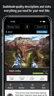
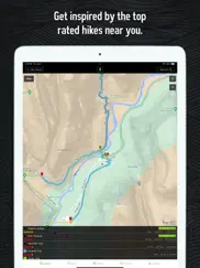
What is hiking project app? Hiking Project is your comprehensive guide to the best hikes near you, wherever you are.
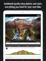
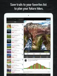
With the thoroughness of a printed map, we offer full GPS route info, elevation profiles, interactive features, photos, and more. Like a guidebook, we suggest the best featured hikes to explore—either near your current location or in an area you search for. Local experts show you the highlights, challenging features, and insights you need to plan a great day on the trails.
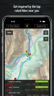
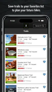
• Find over 74,000 miles of trail to hike with your crew.
• New trails are constantly added to our incredibly detailed hiking database.
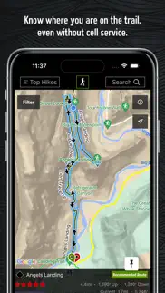
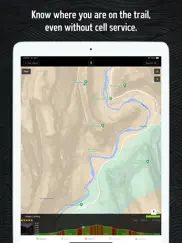
• Your exact location is shown on the trail.
• Downloaded trails work offline for when you’re off the grid. (No cell reception required!)
• Enjoy high-resolution photos and detailed topographical trail maps.
• We’ll sync with your to-do list and check ins on HikingProject.com.
By using GPS, we can show your location on trails and vertical profiles. Continued use of GPS running in the background can dramatically decrease battery life.
😍 Do you love Hiking Project app? Please share your friends!

Please wait! Hiking Project app comments loading...
Hiking Project 4.5.7 Tips, Tricks, Cheats and Rules
What do you think of the Hiking Project app? Can you share your complaints, experiences, or thoughts about the application with Adventure Projects Inc. and other users?
Hiking Project 4.5.7 Apps Screenshots & Images
Hiking Project iphone, ipad, apple watch and apple tv screenshot images, pictures.
| Language | English |
| Price | Free |
| Adult Rating | 4+ years and older |
| Current Version | 4.5.7 |
| Play Store | com.hikingproject.ios |
| Compatibility | iOS 14.0 or later |
Hiking Project (Versiyon 4.5.7) Install & Download
The application Hiking Project was published in the category Sports on 24 February 2015, Tuesday and was developed by Adventure Projects Inc. [Developer ID: 452308787]. This program file size is 76.97 MB. This app has been rated by 1,881 users and has a rating of 4.4 out of 5. Hiking Project - Sports app posted on 29 March 2024, Friday current version is 4.5.7 and works well on iOS 14.0 and higher versions. Google Play ID: com.hikingproject.ios. Languages supported by the app:
EN Download & Install Now!| App Name | Score | Comments | Price |
| MTB Project Reviews | 4.6 | 4,080 | Free |
| Powder Project Reviews | 4.3 | 48 | Free |
| Mountain Project Reviews | 4.7 | 3,700 | Free |
| National Park Trail Guide Reviews | 4.5 | 1,381 | Free |
| Trail Run Project Reviews | 4.6 | 403 | Free |
Bug fixes and maintenance.
| App Name | Released |
| MLB Ballpark | 02 April 2012 |
| LALIGA Official App | 01 August 2012 |
| FotMob - Soccer Live Scores | 21 December 2011 |
| Real - Sports | 02 March 2021 |
| Streameast - Live Sports TV | 28 December 2023 |
Find on this site the customer service details of Hiking Project. Besides contact details, the page also offers a brief overview of the digital toy company.
| App Name | Released |
| RacquetTune - String Tension | 06 April 2010 |
| Applied Ballistics | 12 July 2014 |
| Apnea Trainer | 10 September 2010 |
| Goal Horn Hub | 02 November 2020 |
| REAL Turkey Calls for Turkey Hunting | 09 June 2016 |
Discover how specific cryptocurrencies work — and get a bit of each crypto to try out for yourself. Coinbase is the easiest place to buy and sell cryptocurrency. Sign up and get started today.
| App Name | Released |
| Hive Social | 18 October 2019 |
| Google Chrome | 28 June 2012 |
| YouTube TV | 05 April 2017 |
| PayPal - Send, Shop, Manage | 03 February 2019 |
| 05 February 2019 |
Looking for comprehensive training in Google Analytics 4? We've compiled the top paid and free GA4 courses available in 2024.
| App Name | Released |
| Poppy Playtime Chapter 1 | 08 March 2022 |
| True Skate | 18 October 2012 |
| Plague Inc. | 25 May 2012 |
| Terraria | 28 August 2013 |
| Slay the Spire | 13 June 2020 |
Each capsule is packed with pure, high-potency nootropic nutrients. No pointless additives. Just 100% natural brainpower. Third-party tested and validated by the Clean Label Project.
Adsterra is the most preferred ad network for those looking for an alternative to AdSense. Adsterra is the ideal choice for new sites with low daily traffic. In order to advertise on the site in Adsterra, like other ad networks, a certain traffic limit, domain age, etc. is required. There are no strict rules.
The easy, affordable way to create your professional portfolio website, store, blog & client galleries. No coding needed. Try free now.
Hiking Project Comments & Reviews 2024
We transfer money over €4 billion every month. We enable individual and business accounts to save 4 million Euros on bank transfer fees. Want to send free money abroad or transfer money abroad for free? Free international money transfer!
A must-have for every hiker.. I can not stress how useful this app has been. With it, I’ve been able to find trails that I didn’t even know existed. Each trail has mileage listing, elevation chart, and a description of the trail itself. Directions are readily available on the same page. The app is even able to track your location whenever you lose cellular connection, so there’s no need to worry about getting turned around. More trails are added every day.
Just what I was looking for. There are apps that do things better than this, of course. But none come even close to this considering this is all free. It has offline maps and list of the best hikes for all difficulty levels around me. Would recommend it to anyone who is looking for an excellent barebones to find awesome hikes near you and navigate.
Best source for hikes I have found. We just returned from a wonderful trip to Yellowstone, made even better by the great information on this app. Now I am home finding new places I didn’t know about within hours of my home. This app doesn’t ask you to pay for extra information or only offer you info when you have created an account and given them your info to sell. What a great option.
Way better than AllTrails. The desktop version is more user friendly to find trails than this app, BUT all of the trails you add on the desktop version transfer over to this app, which is awesome! It’s easier to search for a bunch of trails on a computer anyways, personally since it’s a bigger screen. This app gives hikers more of a “community feel” than other hiking apps. It allows you to see other hikers’ trails and where they have been.
Wow!!!. I planned a whole 3/4 night/day backpacking trip and was using a different app. A friend suggested a different section of the trail I wanted to hike, but I couldn’t find the section on the app I had always used. He told me about Hiking Project, I downloaded the app on the drive to Danial Boone National Forest, searched for the trail I wanted when I parked near the Red River Bridge and I was on trail and recording my trip with no trouble at all! This app worked perfectly start to finish! Love it!
Great app, I have used it for years now.. The one complaint I would have is how if you’re recording a hike and your phone dies the app will not recover the hike you were doing before your phone died, it just crashes the app when trying to load it. Other than that 10/10
Fantastic and free.. My only suggestion would be notes or comments so I can update when and where seasonal water is or good camp spots so I can bookmark (pin, gps coods) adding pictures. Also real time tracking when no cell signal is available would be nice I can’t check in, track my progress and mph like in some of the other apps. But it does show me where I am accurately with the altitude which is fantastic, tons of new trails added since last year too!
Very Helpful App. I’m very new to hiking, and just moved to an area close to the mountains. I love that this app gives routes to climbing many of the famous mountains and even combines them. Very easy to use, compared to my original method of merely researching the area on google maps. Also with COVID 19, many of the hiking centers at the parks have limited hours and don’t offer paper copies of the maps. This app provides those and even at some points gave me my location on the trail. Highly recommend this app.
Just what’s needed. I’m a wake up in the morning need to find a trail don’t care where it is kind of guy. I don’t want any technology or noise or people when I decide to go away, but this app literally is awesome. Being able to use it without cell service has saved me from marking wrong turns and bad trails. I admit I feel like cheating when I pull it out to see where I’m at but it also makes me want to explore more without the fear of getting lost. Love it.
The only ethical app out there not charging to use. This is the only non bait and switch hiking app on the market m. The rest will tell you free to use, but “you have to pay to use offline on the trail” making it pointless when free except for planning. Kudos to this app, very detailed and even routes others apps didn’t have!
Awesome, but.... So we’re old farts that love to hike easy to moderate trails. Very intuitive app to filter and find those, BUT many you need to be parachuted into the middle of the wilderness to get to! It’s funny to see little 1 mile easy jaunts the start and end on 17 mile intermediate hikes that themselves are a journey. I’m sure there is an “easy” stretch on Mt. Everest if someone just labeled a start and stop and gave it a name. In spite of that little “flaw,” this is a great app to find those hidden gems that are accessible. Look forward to exploring. Meanwhile, all you young, fit folk can trek those easy hikes on your journey across the Appalachian Trail.
Better than AllTrails. This app is exactly what I was looking for. Features include crowd sourced hikes, photographs, reviews, and user updates to popular trails. Of note, it seems to load with less data than alltrails, and doesn’t drain my cell phone battery as quickly as alltrails either. For a free app, it has everything I need. Paired with a hard map as a backup, you can’t go wrong.
Great for travellers and hikers in the USA. I’m from the UK, and to be honest the hiking community hasn’t really taken up the mantle yet and most of the trails I know at home are notably absent. I’ve been living in the US for 2 years, and exploring the national parks, monuments, and forests. This app has been the critical piece of the puzzle that has helped me plan trips, and feel confident about where to go and what gear to take. It’s also been a great bail out option, because downloading the maps means that I know my location and if I’ve lost the trail. As a solo hiker on unfamiliar trails, this has been invaluable more than once. I recommend this app to everyone. It’s brilliant. And free.
Love this app. Use it whenever we travel. Always make sure you download the state trails BEFORE you head out otherwise it can take a LOOOOOONNNNGGGGGG time. My family always use this app whenever we venture out on our trips. We’ve used it for most states in the Western US. I love that it tracks where you are on the route even if you don’t have service.
Nice maps, but no user content from phone. The app does provide some great maps with lots of useful information about trails. But the app falls flat because users cannot load trails, tracks, photos, or notes FROM THE TRAIL! You have to go home, go to the web site, and share your experience after the trip. I see in the forums that this capability was a “priority” for the developers back in August 2018. Still not seeing this capability 8 months later.
Hard to get set up. When I first started using the app, I couldn’t get any information other than a map of the area where the trail is located. But after fooling around with it some more, I discovered that I have to download a list of trails for the state I’m in before the app gives the information the website does. In a way I like the website better because the map and trail information are on the same page. AllTrails is probably better for an app.
Great for all who desire a good hike. I started getting into hiking on a more serious level several years ago but always had a hard time finding resources that would give me details about a trail. This app not only tells you the trails that aren't on the mainstream, but elevation, trailhead location, pictures, level of difficulty, all you need to know!
Search not working?. Most everything about this app is amazing, and I still recommend it to my friends despite my one problem. Every time, and I mean EVERY time I try to search for a trail it tells me a message saying there’s a search error. I have to go into google maps and then try to sync it with the project app, and it’s a whole thing. Once you find the trail on another app then it works but it should be all inclusive. This app has literally saved my roommate and mine’s live’s one time and I still trust the gps pointer because of it. It is a pain to have to sync up the two apps though. I will continue to use it but there are some major bugs that need to be fixed.
Has bugs, still the best. Certainly the best hiking app because of its downloadable maps and ease of seeing all the hikes in an area quickly. However, Multiple times when I have tried to add content by recording a hike, the app freezes, begins crashing seconds after I open it, and the only way to recover it is delete the app from my phone and re-download it. Pretty annoying, even dangerous, when I was using it for navigation in the Alaskan wilderness where there was no service.
Why did you break my favorite app?. Why did you break something I was able to rely to on the trail? This new version is not reliable and can't be used on the trail anymore, will probably have to switch to Alltrails. - this is not production ready, when you have a great app, don't rush yourself on releasing a new version with SO many bugs and crashes! Like I said not reliable anymore on the trail! - Map is now simply not usable, terrible UX, on top that it is impossible to use because it's slow and buggy. - Why removing the Pin trail feature!? This was so convenient to pin a trail planning my hike and during my hike to simply stay on the trail I'm on, now it's lost in my favorites, and have to sometime spend time looking for itwhile on the trail, what a waste of time... - finally, TODOs and Favorites are two different things! Why rename TODOs into favorite, it's just all confusing for the user, I feel like I lost all my stuffs. The better is the enemy of the good, in other words, don't fix it if it's ain't broke. The hiking project was my best reliable companion on the trail, I was happy to log new trails to be part of the community and help building the trails database, I will now have to use Alltrails. This is sadly not reliable anymore out there, fearing that the map get unusable and might crash trying to use it is not an option.
Wow just wow!. I love to hike but have no sense of direction whatsoever, so when I hike alone, my expeditions involve a lot of wandering on and off the selected trail when I use a paper map. Today I did a 4.9 mile loop with my dog (who is also not a good navigator) and thanks to the insanely fast GPS updating on this app, I could always tell when we were going in the wrong direction. This is so much easier to use than Alltrails, plus no ads. THANK YOU!!
The app that every hiker needs. This is is great app that I have used countless times. Being able to access trail maps off line is fantastic because as we all know, the chances of having a phone signal on trail is slim. Knowing the terrain and elevations is a plus with the app and on my last hike, I tracked my location and kept up with what elevation changes I was about to encounter. My only complaint is that I wish the app could save my hike information (miles, elevation gains, etc.). Until this happens, I have to keep track of my data on another app. However, I am sure that as time goes on the app will eventually be able to do so and more. This app is a valuable tool for every hiker.
Great Beta.. I love the app. Works great with lots of trail beta. The downside. I’m finding more and more on trails here that people are not practicing “Leave no Trace” ethics. This past weekend on a trail I found people literally camped on the trail with fire ash within feet of water sources. For the developer. Maybe when people sign up they could check an agreement box after they’ve read the “leave no trace ethics.” As more and more people head out into the backcountry it’s creating a negative impact that I’ve not seen in nearly 30 years of being on the trails.
Needs to catch up with the website. I really like this app but it lags far behind the website in terms of functionality. The data is stale, can’t submit trails, hikes, photos, or even post comments. Still, this has the potential to be the best of breed and I look forward to the release that incorporates all of the missing features. It’s worth the wait because of the dedicated and highly knowledgeable community and careful management of submissions.
Disappointing. I guess I’m not REI’s average hiker. Maybe the area where I live isn’t populated enough, or maybe trails for locals isn’t REI’s priority. The app is great if all your hikes include forest. All of the trails in the app near me are a) alpine or b) very popular and busy. The trails are just a fraction of what other websites and apps show close to me. While there are popular trails within a very short drive, they are not listed. In fact, the only trails I can find are in national forest land - no BLM, state, county, or city trails, not even when they connect to USFS trails. So if you live in a small town (even one with a reputation for the outdoors) and just want a few good places to spend a an hour or three, there are better apps out there.
Could Use Some Minor Improvements. I had been waiting to see if REI would make a global trails app similar to AllTrails. I like both interfaces of the REI app and AllTrails, and I love the gem feature which the REI app provides. Unfortunately, there a few items I feel could be improved to set it above AllTrails. Firstly, when you’re zoomed out it’s clusters all the trails to identify there are “X” amount within that area, but when you zoom in they all disappear. In AllTrails, you can zoom all the way up to the trail head pin and even tap on it to display the more detailed trail information if desired. Secondly, I noticed when zoomed out to view larger trail clusters you have the ability to tap to view a list of the trails on screen. However, when viewing smaller clusters the option to tap to view the list of trails on screen disappears. Perhaps both of these are coding glitches and were not intended. But if they could be fixed, then this would help streamline the app interface tremendously. The other items I noticed which were lacking in this app, but available in AllTrails, is an in app local weather forecast and the featured ability to record your hike. I did notice you can “check-in”, but being able to record your times is a very nice feature; especially for those of us with a more competitive side.
Best hike planning app I have found. This app has exactly what I was looking for. I use it every weekend to plan hikes with my family and have used it several times to find hikes in other parts of the country while on work trips. It does not include every hike that I know exists, but it will only get better as more content is added. I love that I can track our position using GPS when we are out of cellular range to check trail junctions and progress.
Nice app for finding trails. Keyword is “finding” trails. I would not use this app to plan any hikes. The mileage is consistently off by a mile or more. Dicey’s Mill Trail up Passaconaway is 4.6 miles, not 3.9. When stringing trails together this can make for a trip that has the potential to be off by 2 miles or more. That’s pretty bad for novices who may not hike with essential gear (and many don’t). Do yourself a favor and get a paper map for your location and a guidebook. This is no substitute.
Terrific planning tool and good in the field too. This app is awesome for trip planning, especially the elevation profiles, reviews and photos. Sometimes it’s a little sensitive when you’re trying to navigate around a given area on the map, and it would be great to be able to reverse a route. But minor suggestions for an otherwise very useful tool as a backup to your paper map and compass.
Fantastic app, but still needs tweaking. I have used this app extensively in my travels around the US to find great hiking trails. And I love it! But I just discovered a local trail incorrectly showing up for hiking when it is in fact dedicated for Mountain Biking. As such it would be dangerous to hike there for both the hiker and bikers. But, there was no option I could find in the app to report this error, other than the “trail condition” report. Go ahead and use the app, but pay attention to the local signs and alternate online info before going!
New version is terrible. You guys have absolutely destroyed what used to be my favorite hiking app. The new version is buggy and unresponsive to the point of frustration but even more then that is the removal of so many good features. It doesn’t make any sense to me. This app used to be a great tool for finding new hikes and points of interest; however, you can no longer search by gems or most popular hikes. Now you either have to already know what hike you’re looking for or wander around a glitchy app till you find something. I couldn’t be more disappointed in the developers. If it’s not broken, don’t fix it!!!
An Incredible Tool. Whether you are a novice to hiking or you’re an expert, this app is a must have. The Hiking Project is an awesome resource for planning your next hiking adventure; it also makes a great resource while on the trail. It’s trail library curated with excellent standards for photographs and GPS accuracy when submitting new trails to the system. The elevation graphs of the trails are extremely informative and so is the fact that the graphs are interactive. And most of all, this app allows you to accurately determine your own location on the trail in situations where you are conserving your phone’s battery by disconnecting from your cellular network or if you simply lose service. I still use good, old-fashioned maps of course but a multimodal approach to adventuring has always worked best for me. This app has helped increase my confidence and overall experience out on the trail. Whether backcountry camping or embarking on a day hike, I never play outside without it.
Great App, a couple hang ups.... I love the app. I use this app and it’s counter part for mountain biking as well (MTB Project). It is accurate with GPS, it has offline capabilities for maps without a subscription *ahem* (All Trails), and it has great reviews of the trails with topographical data that really lets you know what you are getting into. The two snags I have with this app are small issues. The first is that it doesn’t save the total time of your hike when you save a GPS Tracking Record from a hike, and the second deal is that the forums for this app are on the website but not the app. It would be nice integrate those two things into the app. This is by far the most amazing hiking enthusiast app out there. Download it! You won’t regret it if you love the outdoors.
THE best hiking app. This app will keep you on the trail, no matter what. And you can find any kind of hike, anywhere…even if offline. What more do you want? How about comprehensive profile and descriptions of the trail, along with photos, reviews and driving directions. This app really does it all. We have used it across the country from Olympia to Acadia. Has not let us down! Love this app. Thanks!
Great app to find hikes. I’ve only recently started to hike and this app has been really helpful to find places to check out. I can find hikes that are appropriate for my level and it gives me an idea of what to expect. I really wish there was a scale on the map view though. There have been times we wanted to make changes to a planned walk, but it was difficult to get the length of just one segment. It always highlights a whole trail when maybe I just plan to go on some of it. A scale would make it a lot easier to plan if it’s an appropriate distance.
A go-to app for hiking. An amazing resource for finding hiking trails wherever you are. The rating system is easy to follow and I love knowing the basic elevation gains/losses of the trail. Plus, it can find you offline so you always know where you are on the map. It would be great to have more detailed information for every trail. But my guess is that will come with time and updates.
Loving this app!. We tools this app out for a spin over the weekend, and it was fantastic! Being able to browse all of the trails at a glance in the area (we were visiting Mt. Laguna in Southern California at the time) was fantastic. Finding a trail with just the right length was obviously great, but one of the features that proved to be quite invaluable was the trail highlight and GPS feature. Being able to double-check our location against the trail meant never wondering about whether we had taken the right spur (as there were multiple cross-crossing trails along our path) and at one point when we got lost in conversation, we were able to double-check our location and find that we had missed the narrow off-shoot we were to have taken while enjoying each other’s company. Another incredibly helpful feature was the elevation overview for the trail. Taking a look at it meant being able to ration energy and plan food and water breaks more easily, as well as determining when to take an impromptu break before one of the bigger gains in elevation along the trail. It’s been a wonderful, beautiful little app so far, and I can’t wait to see where else it takes us. Happy trails everyone!
Want to give up on klunky adding trails function. I really want this project to succeed. But every time I record a GPS track and try to add it as a trail, I run into a klunky, hard to use interface that makes me wonder why I bother. I record my track. Now to add it as a trail, I have to go to my profile (Why?), select “Add a Trail”, then scroll all the way down to another page to use my recorded track. Then I get sent to the web interface, where map editing is impossible on a small screen. And why force me to edit the map? There are so many selections and descriptions to fill out after that. And tonight I did a big edit, and it was all lost. Clue: if “how do I recover my lost edit text” is on your FAQ, and the lame answer is “try your back button”, then your site is failing basic usability criteria. You’re not respecting the time I take to fill in data that your site can’t even bother to put into a buffer? Why should I bother? Make it easy to add a trail from the app (not the website) and make it reliable. Otherwise I might as well go donate my time to recording tracks for AllTrails instead.
Very useful. I use this app a lot, even when not on a trail but just to track a walk. I use it to check my location in relationship to the trail when it’s covered with snow. I wish you could scroll around the screen when in record mode, this would be useful for navigation. All in all, I really like the app.
Offline maps?. I see no downloadable offline maps option, which is the core of what this app reports to be. Get on the bandwagon! It must be because it uses Google Maps API rather that the publicly available USGS topo. The best you can do is pre-view the entire route at a decent zoom level before you go in order to cache the Gmap as much as possible, but the result is varying quality and is very limited. It’s pretty crappy actually. The trail sharing community component on this app is probably great (especially because it’s free) but without an permanent offline topo basemap the app is pretty useless for its purpose. Sure I can make a breadcrumb trail with this app but I also want to use the same app to view my route options ahead, this especially when I’m taking an uncharted course. I’ll wait until to use this app until it uses a real offline maps (not just spotty cached map data and offline trail lines). It seems that they don’t intend to make this happen though as users have been asking for it for 3 years.
Love it!. I am a directionally-challenged woman who loves to hike unknown trails by herself and this app has saved me more than once. The portion of the AT that goes through my area is thoroughly marked and easy to follow. However, I enjoy solitude and like to hike places others don’t. Those trails are typically horribly marked and/or overgrown. I have relied on this app several times to keep me on track and safe. I also use this app to find trails near me that I’ve never heard of/done. I love it!
Essential offline hiking map app!. Just like the MTB Project, this app works really well when you’re out in the woods without service, but overlays your GPS signal upon the downloaded off-line maps. It’s really fast and easy to use, and your location shows up on the elevation portion of the trail map while you are using it. Can’t recommend higher!
Life saver!!!. I went on a backpacking trip to Santa Rosa Island in the Channel Islands National Park. The plan was to camp at Johnson point, bit off way more than we can chew. So as we realized that completing the trek was isn’t in the cards I tried AllTrails but nothing I remembered about this app cause REI was out of physical maps. I opened it up as boom a couple of tiny barely visible trails, so after navigating about 5 trail junctions I got a glimmer of hope and saw the ocean(small dot of blue). After that enjoyed 3 days of seeing absolutely nobody on my beach and it wouldn’t happen without this app
Great app, with one big caveat. I have used this app for years, all over the US. It's great for finding trails, seeing photos of them, reading descriptions, and so on. It's been a huge help to planning many vacations. There is one "but." In my experience this app consistently under-reports trail distances, often significantly. This week, for example, a hike in the Grand Canyon that the app lists as 2.9 miles registered as 4.1 as-hiked for me with a GPS tracker, and a hike in Sedona that the app lists as 5.4 miles registered as a 7.8 as-hiked for me with a GPS tracker. Those may not seem like big differences, and in absolute terms maybe they're not. But they're each off by more than 40%. These two examples were not a problem for me, but if you're hiking a challenging trail on the edge of your experience level, or hiking in bad weather, or fighting darkness, the trail turning out to be 40% long than expected is bad, bad news, and a legitimate safety issue. Forty extra percent turns a ten-mile hike into a 14-mile hike, and a 20-mile hike into a 28-mile hike. My advice: use this app, but build in a significant buffer on the distance.
Used to use Everytrail, then AllTrails. This is excellent.. This is a terrific app. It does not have all the features of AllTrails (like photo embedding on your tracked route), but it has all the features I want. I love the interface vs AllTrails and Gaia. Very easy to find hikes. In the map view, trails are color coded the same as ski trails: green=easy, etc. Can import, export GPX and recommend trails to be added. Download offline maps, track your route with all elevation stats. I’m currently stuck in Reno as the ski season ended abruptly with the coronavirus. But only 45 minutes from Lake Tahoe, and via Mount Rose Highway, still in the same Nevada County, so not breaking any orders. At least we can leave our own neighborhood for exercise! With 80 hikes in the Tahoe area I’m not going to get bored.
Handy tool for the Appalachian Trail. I used the app to pick a trail segment to hike on the Appalachian Trail. I was able to download the map in advance (very handy since there was minimal data service during the hike). During the hike, it was really handy to see our progress via GPS, see Scenic Looking Spots and view nearby segments. I would like to see information added to the app about when we have to cross a street to continue on the trail and step by step instructions to get to the next segment. It would also be handy if the firepits were marked. We reached the end of the segment, didn’t realize we had to cross a street to get to the shelter further ahead. Then, we spent 30 minutes of hiking searching for a campsite with a fire ring. We were so tired we almost gave up. I’m very pleased with the app overall and will use it to find more local trails and hike other AT segments in the future.
Love the app but missing some key features!. I love this app and think the Hiking Project is better as whole compared to other hiking apps but it is missing some key features that are available on the website which keep it from being the best. I wish we could upload our trails, photos, or comments about hikes through the app since you are able to do these things in almost every other hiking app. Seeing other people’s comments about their hikes would also be super helpful since they could provide some relevant recent information about the trail. I don’t like having to use the website (or other hiking apps) just to have these functions.
Not easy enough to add trails or have comments. There's a reason Alltrails has more trails and more people using it, because it is way easier to read and add comments. This app is way better, I love being able to see all the trails on one map instead of just a single waypoint at the trailhead like in Alltrails. You need to do something about this because you don't have as many trails as Alltrails so I have to switch back and forth and also I have to go there when I need recent comments on the conditions and more specific directions.
What happened to this app?. This used to be my favorite app. I told everyone about it. Now it loads to show the area I’m in but won’t show any of the trails. And these are places I’ve been before and used this app so I know they were there. My phone does not show any update available. Very sad guess I’ll have to look for a replacement
A must have for any hiker. This app is a must have for anyone venturing into the woods. I love how the GPS keeps working as you lose signal so you can still know where you are. It is a feature rich tool for maps, elevation, photos and more. My only wish is that users could login and leave a review or notes on hikes (took my dog on a hike rated as “dog friendly” and could have used a note that the route included a dog scramble).
Did you know that you can earn 25 USD from our site just by registering? Get $25 for free by joining Payoneer!
Easy to use, exactly what you need from a trail app. Best trail map app. Great work REI.
Great app with most required features. If the app can add the estimate time to finish the track will be great. I am using this app to plan my New Zealand hiking however I have to navigate to the other website to find the estimate time required for the track
Imagine you at your best. All the time. Picture yourself at your sharpest and most productive. Your most alert and focused. Your most lucid, creative and confident. At work. At play. In every area of your life. Add Mind Lab Pro® v4.0 to your daily routine and uncap your true potential. Buy Now!
Use. User interface face is clunky and not well designed. Could be a lot better. Very limited user functions for adding trails to find the trail head. Then let users completed it once they find it to give users a more completed list to choose from. Then they can fill out the maps 100% and hike it. Can’t minimize a trail from the bottom of the screen. Can’t go through a list, get more details without having to refind the list and to go back through again. Really frustrating app that could have a lot of potential
Not enough Canadian trails. It’s really hard to find an app that actually has a substantial amount of Canadian trails.
Adsterra is the most preferred ad network for those looking for an alternative to AdSense. Adsterra is the ideal choice for new sites with low daily traffic. In order to advertise on the site in Adsterra, like other ad networks, a certain traffic limit, domain age, etc. is required. There are no strict rules. Sign up!
Lost? Help is here!. One of the best travel apps ever. If you’re one of us who likes to get away from the crowd, out on trails that led to places most never see, this is the app for you. Hiking Project allows you to download hiking maps of whole regions! Free! The app includes maps elevations, trail ratings, and even other hikers’ pics. And it uses your phone’s GPS to keep constant track of your location. Away from cell towers. Not sure which fork to take? Just choose one, walk a few dozen steps, and check your phone. It’s that precise. This is just me of the best deals out there. If you’re a hiker, you need this.
Great app for trail finding!. Downloaded the app yesterday and decided to try it. So glad I did because the way down a trail was very difficult to find, and the app took us right to the trail when we were turned around. Great features!
Save your time and space on your phone and stick to alltrails. Downloaded app with full hope that it would be better than AllTrails. I downloaded all of California and Colorado. Trails showed up for about a minute before disappearing. I did the sync process multiple times afterwards and even closed out the app all together to get the trails to show up again. Nothing worked Save your time and space on your phone and stick to all trails
Love it so far. Just started using this app love it so far are used it on the mountain was able to orientate mysele, also used the driving directions and all seem to work well I look forward to using it in the future.. It is a good source of information.
Recording a trail. The app is pretty good except, if you are recording your trip on a marked trail the app will not let you look at the area around you. When I pause to look at other trails that intersect the app won’t let you “pinch” to expand and look at details.
The Hiking Project...almost perfect.. This app is great for finding and submitting new trails to the hiking community. The only thing missing is an option to highlight the trails you’ve already hiked based on your user profile. Driving directions ti trailheads have been spot on and the download for a State’s trail system is awesome for offline use.
Great hiking app. I’ve used this app in the Sierra backcountry on an 8 day backpacking trip. It doesn’t require cellular so I can set my phone to airplane mode and go days using the phone for this app and photos (of course). I’m using it now in Maine on Mt Desert Island and it’s equally awesome. Lots of trails with descriptions and difficulty ratings.
The only ethical app out there not charging to use. This is the only non bait and switch hiking app on the market m. The rest will tell you free to use, but “you have to pay to use offline on the trail” making it pointless when free except for planning. Kudos to this app, very detailed and even routes others apps didn’t have!
Curated and accurate, works offline. Love the curated Featured Trails, and Spotlights! The download area feature actually works, and the app preserves the battery veru well. Tracking and recording is also much better than AllTrails. And it is Free.. wow!
Used to be good. This app used to be reliable. Now everytime I open it all of my downloaded maps are deleted and I have to redownload them. You also can't favorite anything without registering a stupid account. I don't want to signup for your service, just charge for the app through IAP or make it free. This app is too unreliable to trust anymore so I'll be deleting it. Apple is supposed to be adding trails and offline maps to the Maps app anyway. Goodbye to this trash.
Buggy with newest version. After the UI update, the map jumps around and makes it impossible to find what I’m looking for (I end up in Utah instead of Colorado and then the map freezes.) Beyond the bugginess, I’m disappointed in the UX changes, I was trying to find a trail with my friend and I got so confused. The old app was great - it’s awesome to improve on it with fresh design but only if the core functionality still works!
Get this app!. I don’t rate apps because they are just supposed to work. I’m rating this app because it works so well and is FREE. I’ve found the trail database to be extensive and generally accurate. WORKS OFFLINE. Hey, did I miss the junction? Pop the app open and quickly verify your location. Great trail info for planning purposes. GET THIS APP!
Issue with "Search Error" lately. Unable to search now for any trails whatsoever. Uninstalled and redownloaded app and maps by state. On the map you can see trails but when you try to search for a specific area you get an error message that pops up. "Search Error. There was a problem with your search, please try again." The app is usually good but without the ability to search it is worthless.
Great Hiking app -. This is easy to use gets you to the trail head with directions and keeps you on the hiking map so you always know your location. Just a great app and just what I would expect from REI. Have been using this for years since it was first released.
Most helpful!. I found this app to be super useful as I hiked around Utah, an area I knew nothing at all about. The insights helped find the best trails for my wants and plan accordingly. Love the fact that maps can be downloaded ahead of time and used even when there is no signal. Useful in so many ways!
Great offline maps. This app can be used off the grid as long as you download the maps for the state your in while your still connected.
A once-great app wrecked by a senseless “update”. This used to be a great, easy-to-use app for finding trails. However, a recent redesign has left the app plagued by glitches and slow, erratic performance. For example, if you tap a trail on the map and then scroll across the map to view other trails, the trail description at the bottom of the screen begins to frantically jump between different trails at a dizzying pace. In addition to being an eyesore, this behavior slows the app considerably. I much preferred the old version.
A Lifesaver❤️❤️🙏🙏. This is the best hiking app on the planet. Gives specific directions, very reliable and shows you many different trails to take Incase your feeling adventurous. It doesn’t even require internet, also, there’s a to do list, so this app serves as a journal as well. The reviews also give you and idea of what the hike is like. Love this app.
Good start. It’s a good start of this app but am having some difficulties with few things. On the phone, cannot do trial search (it comes up empty) and there’s no filter capability for me to narrow down the trails to check out. There’s no GPS for us to time and track our live hiking on a trail (not sure if you have an intention to do such as that). Overall, if you know the name of the trail and where exactly it is, can easily find it on the map and check it off as completed.
Top Notch!. As a crowd-sourced app, I’m happy to contribute. This app is so good, I’d even donate! Rich with information and improving all the time, you will definitely find it useful on or off the trail (live use or planning). Forget the subscription apps, put your energy and resources here, and enjoy the benefits that come from great hikes!
Favorite trail/nav app!. I’ve been using this app heavily for the last few months now and it’s been great help this week hiking in Colorado. Works great even when you have no cell coverage (as long as you’ve downloaded the area you’re hiking in before hand).
Good, but not great. Coming from Washington, I feel spoiled with the Washington Trail Association’s resources. Two additions I’d personally like to see would be the ability to filter out hikes based upon season, and the other would be when using the “best of” feature, being able to do a “best of” near a city or area you will be, rather than the entire state.
Near perfect. With great detailed information on trails and terrain, this is the best resource I’ve found for getting specifics on proposed routes. This map along with a hard map and you can truly plan to make the most of your time out there!! Keep going, I can’t wait for new individual route planning functionality!!
Convenient and Accurate Trail Guides. I’ve used this app to find new parks and trails, and its maps are very helpful when hiking a new trail. The interactive map allows you to track your progress and location on your hike, and the collective hiking community is always adding new photos and information about the trails. Highly recommended!
Cliff Austin. This app is fantastic. The ability to search by text or search by map is great. Simply click on the trail on the map and instantly you get descriptions, altitude, reviews and even history about Some areas. There is also an app for mountain bikers. Equally as fantastic.
Easy & Accurate. While I always have a paper map, Hiking Project is a great tool for when things get confusing. It’s super easy to use and to download areas for GPS-only use, and I’ve been impressed with the accuracy in tight spots. Thank you Hiking Project!
Outstanding. Great app to use! I love how I can see campsites and hiking trails. Already downloaded go when I have no more service. I can see trails everywhere and see updates. Also it’s free which is one the best parts. Also very clear and easy to use which is also a favorite part.
What happened to this app?. This used to be my favorite app. I told everyone about it. Now it loads to show the area I’m in but won’t show any of the trails. And these are places I’ve been before and used this app so I know they were there. My phone does not show any update available. Very sad guess I’ll have to look for a replacement
Amazing app. I absolutely love this app and the simplicity of it. One thing I think would be great is to add an average time for the trail. It would be great to be able to see how long it typically takes somebody to hike this taking in steepness and mileage wise.
Best hiking app ever!. Thank you for creating this! It has helped and saved me in so many situations without having cellphone service in Colorado mountains. I have also helped countless amount of fellow hikers who were once like me and didn’t know about this app! Keep up the good work!
Not reliable. I have an ongoing problem with the app not recording my hikes. I turn it on, put my phone to sleep, and put it away. Sometimes I come to the end of my hike and it’s just stopped recording. The hike is nowhere to be found. Other times, it paused itself and only recorded the beginning of the hike. It’s quite frustrating. I have 68G of memory free, so it’s not a resource problem. My cell service is from AT&T, if that matters. I’m looking for alternatives.
Great Resource. This is a great way to save trail map papers, this digital wonder map is extremely accurate. I loved how even if my service went in and out the map stayed the course like a GPS. I’ve noticed also in my home state new trails added to some local state parks were loaded in the app before any printed material! If you are an avid hiker use this.
Disappointed in this app. After reading all the reviews carefully, as many of them were over a year old, I had hopes that some of the deficiencies would be corrected and this will be a great app. Did not work that way. The user interface is not intuitive, and there’s no way to filter for things like dog friendly, which was suggested many, many times and reviews. Maybe I’ll come back in a year or so look at again.
Please change back to previous version!!. The redesign of this app has several problems. Hikes shown at the bottom rapidly change even when I am not zooming or shifting the map. Also, the view randomly jumps from the area I am exploring to my current location. Very erratic behavior. In addition, this version is just less user friendly than the previous version. I wish this would revert back but I know how this app thing goes...we are stuck.
Essential before and during the hike. Hiking Project is an excellent resource for planning hikes, including routes and current conditions. Hiking Project is also useful during hikes, even with no cell service, as it’s a GPS-enabled map of your route, so you can check to see if you’re still on-course.
Great for tracking workouts and challenging yourself. It’s a good app to keep me and my girlfriend motivated but not too keen on the friends you can get. Seems too much like a dating app. But being able to record your routes was amazing. I also like the challenges keep me thinking about what workout I’m going to do next.
Nice maps, but no user content from phone. The app does provide some great maps with lots of useful information about trails. But the app falls flat because users cannot load trails, tracks, photos, or notes FROM THE TRAIL! You have to go home, go to the web site, and share your experience after the trip. I see in the forums that this capability was a “priority” for the developers back in August 2018. Still not seeing this capability 8 months later.
Best Hiking App Ever. Best App ever. Cannot believe this app is free. I would love to make a donation in support. It is all the info you need to plan a short or multi day hike. Detailed and accurate info about everything from trail head location and complexity, to what to watch for. With pictures, maps, and inclines.
Best Hiking App. This is by far the best hiking app available! The trail maps, especially the topography and georeferencing, are really helpful and easy to use. I love that this is crowd sourced and it’s so fun to contribute trails. On top of all of that, it has never asked me for money a single time. I cannot overstate how much I love this app!
Great idea, poorly implemented. You cannot upload a favorite hike unless the trail has an official map. There’s 30+ trails in my area that do not have ‘trailhead maps’ or official routes so I can’t upload anything. With that policy you cannot submit a County, City, or a local park’s trail anywhere in my area. I’ve tried uploading several trails; an incredibly difficult process on a smart phone. It took me more than 4 hours to get to the submit phase on my first trail, only to get an email some weeks later saying they need a “trailhead map” or online map. I sent the municipal website & local newspaper site that explained the dedication ceremony, and [land] donors for that trail as it was brand new.
Every Hiker Should Use This App. I can’t say enough good things about this app. It works without service so you can see a trail map, you can use the feature that shows you where are you at on the trail, including your elevation gain. It’s saved my bacon multiple times! And a great resource for planning future hikes!
Good map backup. I use your app with other apps that have better written directions but the maps are not live. Your map shows the hikers location even when the phone has no communication links (no bars for the phone). You can track yourself any where shown on the map, even on adjacent trails. So, it allows me to see whether I am making correct turns or are off trail. Saves so much time back tracking when you think you have lost your way. Very accurate so far. You can actually see your placement dot rotate as you walk in various directions. I’ve used it in: NY, VA and ME
Nice app for finding trails. Keyword is “finding” trails. I would not use this app to plan any hikes. The mileage is consistently off by a mile or more. Dicey’s Mill Trail up Passaconaway is 4.6 miles, not 3.9. When stringing trails together this can make for a trip that has the potential to be off by 2 miles or more. That’s pretty bad for novices who may not hike with essential gear (and many don’t). Do yourself a favor and get a paper map for your location and a guidebook. This is no substitute.
Missing a lot of trail listings. This hiking app is good I Especially like the pin map feature , but it sure does not have ALOT of hiking trials listed ON IT. I sometimes have to use other hiking apps like “all trails” in order to find trails not listed in this app. This app should have most if not all hiking trails listed . For now the “ all trails “ app has all the hiking trails i have looked up .
No way to download the map of the trail. You are unable to download the map of the trail the same way you can with “all trails.” I think this app would be amazing if you could do that as well as see reviews other people have left on a trail and be able to use the app offline. This app is promising but has a long way to go!
Almost got lost. We followed the trail map and several obstruction were able to get back on track and finish our hiking. Easy to use for a couple of 50+ years old.
Highly Recommend!. I absolutely love this app and use it on all of my hikes. I try to avoid subscriptions so I'm always on the lookout for quality free apps. It's amazing the features that this app includes! I've used it from the Enchantments hike (22+ miles) to Camp Muir (basecamp of Mount Rainier).
Hike Location. Need to have a feature similar to Alltrails where there is a icon that shows a location for hikes in a local region. Then the user can select at it will expand to show you the options. Right now the user sees a lot of trails going everywhere, hard to decipher which ones go where.
Great app. If you have access to cell service or want an app to track your routes without paying, it’s a great app. My one issue is that I can’t see how to go back and review or edit previously saved hikes. If you could fix that, 5 stars
Bidwell upper park Chico California. I live in Chico and hike here all the time and use it for training to go on other hikes around the world and I found this app spot on Just an update for the readers Dogs are allowed in all areas of the park on leash however on the north lower, mid and upper rim trail area you can let you dog off leash YIppee !! You can let your dog walk by the creek and let them play in the water but dogs must walk on leash close to the creek Also we have rattlesnakes especially during spring and summer so during these months I keep my dogs on leash for their protection Great park !!