Scenic Map Western Canada App Reviews
Scenic Map Western Canada App Description & Overview
What is scenic map western canada app? A 3D topo map of Western Canada. All map data is dowloaded to your device and can then be used without an internet connection. Use it in a car, a boat, a plane or while hiking. It is like having more than a third of the country in your pocket.
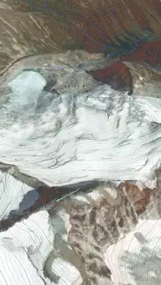
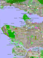
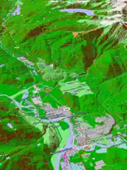
Scenic Map now covers the entire world via online maps. The maps are cached automatically so they can still be used when there is no cell coverage. Turn on Online Map in the Settings menu and you can then scroll or go to any location on the planet. Satellite image overlays add breathtaking detail and realism to the maps (tap preset 2 or 4 when Online Map is enabled). You can use them as you travel to see what is hidden from view at ground level. This takes moving maps to a whole new level.
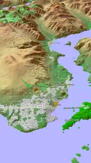
Use the two finger vertical swipe gesture to tilt the map for a 3D view. Scroll like a map or fly like a flight simulator. Enable Joystick Gestures in the Settings menu and then fly around the terrain using a virtual joystick. Prefer only 2D maps? Enable the 2D Map option in the Settings menu.
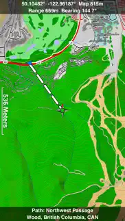
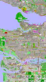
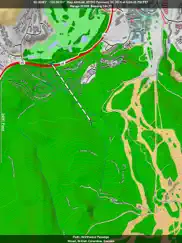
Scenic Map is simply the best 3D topo map available for a mobile device. You will see incredible detail while scrolling, rotating and zooming perfectly smoothly. You will see every road even if you zoom out to the altitude of a satellite. As you zoom in, you will see every small bump and hollow of the Earth and terrain features as small as ten meters. Unlike old fashioned topo maps, Scenic Map’s roads and trails are up to date thanks to OpenStreetMap.org. It contains polygons for urban areas, shopping malls, an ever growing number of buildings and many other features, The best lake, pond, stream and rivers from the USGS and Canadian public databases are also included.
Tap the GPS center button to begin tracking your location. As you move, you will generate a track file. Tracks can be replayed with video like controls to speed up, slow down, pause, restart or skip to the end. You can display existing tracks while recording another if you want to retrace your route. When online, you can automatically create a route from your current GPS location to any other point on the map. Tracks can be received from or sent to other apps in GPX format. GPS recording stops automatically after you have remained stationary for some time or you can choose to manually stop tracking by tapping on the top track in the Tracks view.
Never before have maps been this customizable. For example, you can turn on or off the roads. You can change the lighting direction or remove terrain shading entirely. You can display contour lines even over satellite images. There are five presets which let you quickly switch between map styles. Use Metric, English or Nautical units and choose one of four different coordinate displays including UTM.
Want to learn more about a map feature? Tap the target icon and center the feature under the compass rose to display its name, type, urban area, county, state, elevation and coordinates. You will also see a bearing line back to your current GPS location or from your location to a selected waypoint. The status bar shows the bearing direction and distance along with the map and GPS elevation, the track length, and your current speed and direction of travel.
In-app documentation is provided in the Help section at the top of the Settings menu. Links are provided in the documentation to detailed coverage maps, tutorial videos, installation guide and blog at ScenicMap.com
Map data © OpenStreetMap and contributors under the Open Database License
Scenic Map supports GPS tracking while the app is in the background.
Caution: Continued use of GPS running in the background can dramatically decrease battery life.
😍 Do you love Scenic Map Western Canada app? Please share your friends!

Please wait! Scenic Map Western Canada app comments loading...
Scenic Map Western Canada 1.9.2 Tips, Tricks, Cheats and Rules
What do you think of the Scenic Map Western Canada app? Can you share your complaints, experiences, or thoughts about the application with GrangerFX and other users?

Scenic Map Western Canada 1.9.2 Apps Screenshots & Images
Scenic Map Western Canada iphone, ipad, apple watch and apple tv screenshot images, pictures.
| Language | English |
| Price | $3.99 |
| Adult Rating | 4+ years and older |
| Current Version | 1.9.2 |
| Play Store | com.grangerfx.ScenicMapCanadaW |
| Compatibility | iOS 16.1 or later |
Scenic Map Western Canada (Versiyon 1.9.2) Install & Download
The application Scenic Map Western Canada was published in the category Navigation on 19 February 2013, Tuesday and was developed by GrangerFX [Developer ID: 363698835]. This program file size is 66.39 MB. This app has been rated by 15 users and has a rating of 1 out of 5. Scenic Map Western Canada - Navigation app posted on 19 January 2024, Friday current version is 1.9.2 and works well on iOS 16.1 and higher versions. Google Play ID: com.grangerfx.ScenicMapCanadaW. Languages supported by the app:
EN Download & Install Now!| App Name | Score | Comments | Price |
| Blue Hound Reviews | 4.6 | 717 | $1.99 |
| Scenic Map Eastern Canada Reviews | 1 | No comment | $3.99 |
| Scenic Map Eastern USA Reviews | 5 | 6 | $4.99 |
| You Need A Map Reviews | 4.2 | 46 | Free |
| Scenic Map Central Canada Reviews | 1 | No comment | $3.99 |
Fast initial download. Maps are then dowloaded automatically. Fixed track recording in iOS 17. Fixed the settings menu in landscape mode on iPhone. Fixed low frame rate when the information bar is enabled. The map's highest detail is now displayed while scrolling.
| App Name | Released |
| Google Maps | 12 December 2012 |
| Premium Parking | 22 October 2013 |
| EV Connect | 09 June 2017 |
| Find my Phone - Family Locator | 08 January 2013 |
| Neshan Map | 04 May 2023 |
Find on this site the customer service details of Scenic Map Western Canada. Besides contact details, the page also offers a brief overview of the digital toy company.
| App Name | Released |
| Aprs.fi | 02 December 2015 |
| Phoenix Zoo - ZooMap | 19 December 2021 |
| Bronx Zoo - ZooMap | 16 May 2021 |
| Spyglass | 04 October 2009 |
| Tactical NAV | 14 February 2011 |
Discover how specific cryptocurrencies work — and get a bit of each crypto to try out for yourself. Coinbase is the easiest place to buy and sell cryptocurrency. Sign up and get started today.
| App Name | Released |
| DoorDash - Food Delivery | 10 October 2013 |
| Telegram Messenger | 14 August 2013 |
| CapCut - Video Editor | 14 April 2020 |
| 05 February 2019 | |
| Google Maps | 12 December 2012 |
Looking for comprehensive training in Google Analytics 4? We've compiled the top paid and free GA4 courses available in 2024.
| App Name | Released |
| Poppy Playtime Chapter 1 | 08 March 2022 |
| Purple Place - Classic Games | 17 May 2019 |
| Minecraft | 17 November 2011 |
| Monash FODMAP Diet | 17 December 2012 |
| Plague Inc. | 25 May 2012 |
Each capsule is packed with pure, high-potency nootropic nutrients. No pointless additives. Just 100% natural brainpower. Third-party tested and validated by the Clean Label Project.
Adsterra is the most preferred ad network for those looking for an alternative to AdSense. Adsterra is the ideal choice for new sites with low daily traffic. In order to advertise on the site in Adsterra, like other ad networks, a certain traffic limit, domain age, etc. is required. There are no strict rules.
The easy, affordable way to create your professional portfolio website, store, blog & client galleries. No coding needed. Try free now.
Scenic Map Western Canada Comments & Reviews 2024
We transfer money over €4 billion every month. We enable individual and business accounts to save 4 million Euros on bank transfer fees. Want to send free money abroad or transfer money abroad for free? Free international money transfer!
Did you know that you can earn 25 USD from our site just by registering? Get $25 for free by joining Payoneer!