Guru Maps - Navigate Offline App Reviews
Guru Maps - Navigate Offline App Description & Overview
What is guru maps - navigate offline app? Detailed and easy-to-use offline maps. We have millions of points of interest (POI) on our maps. Record your GPS tracks and bookmark your favorite locations.
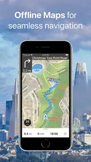
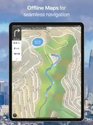
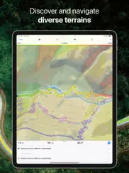
OFFLINE MAPS
• Amazingly-detailed maps covering the entire world.
• Based on open data from OpenStreetMap project.
• Download once, then use offline without restriction.
• Maps updated monthly with most-recent fixes and additions.
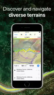
OFFLINE NAVIGATION
• Turn-by-turn driving directions.
• Voice instructions while navigating available in 9 languages.
• Routes for Driving/Cycling/Walking/Shortest Distance.
• Automatic rerouting gets you back along your way.
• Supports intermediate points on your itinerary.
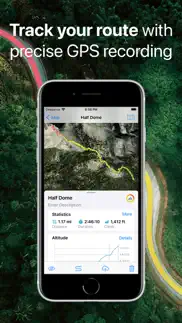
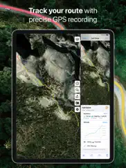
GPS TRACKS
• Record your trips even when the app is in the background.
• Monitor your real-time speed, distance, and time traveled, as well as altitude right on the map during the trip.
• Choose from seven solid track colors, or altitude and speed gradients.
OFFLINE SEARCH
• Incredibly fast – results appear instantly as you type.
• Search in a variety of ways – by address, object name, category, or even by GPS coordinates.
• Searches simultaneously in multiple languages, making searching easier than ever.
BOOKMARKS
• Save favorite places on your map.
• Choose from a variety of map icons.
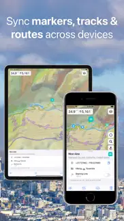
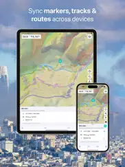
SYNCHRONIZATION [Pro]
• Sync your data across multiple devices.
• Data saved on a server as a backup.
IMPORT AND EXPORT
• It's easy to export your tracks, bookmarks, or your whole travel collection as a KML or GPX file.
• Organized into collections for easy access.
• Offline maps can be imported from sqlitedb/mbtiles format. [Pro]
ONLINE MAP SOURCES from thunderforest.com [Pro]:
OpenCycleMap, Outdoors, Transport, Transport Dark, Landscape, Mobile Atlas, Neighbourhood, etc.
SMALL FEATURES
• .GeoJSON file format is supported to display map overlays.
• One-finger zooming.
• Trip computer with speed and altitude.
• Tracking mode.
• Coordinates and scale.
• Customize what objects are visible.
• 11 different map languages to choose from.
• Adjustable label size.
PRO SUBSCRIPTION
Without subscription it's possible to create up to 15 bookmarks, record up to 15 tracks and have only 3 vector maps downloaded on your device.
Subscription allows you to create unlimited bookmarks and record unlimited GPS tracks, download unlimited maps, sync between devices, use Pro map sources and import offline raster maps in sqlitedb/mbtiles format.
Guru Maps Pro offers two payment options (prices may vary by location):
• monthly or yearly subscription (with 7-day trial version),
• one-time purchase for lifetime license.
For those who paid for any in-app purchase earlier, a lifetime subscription is activated automatically.
Should you choose to upgrade to a Pro subscription, payment will be charged to your iTunes account at confirmation of purchase. Subscription automatically renews unless auto-renew is turned off at least 24-hours before the end of the current period. Account will be charged for renewal within 24-hours prior to the end of the current period.
You may cancel automatic renewal and manage your subscription by selecting Manage App Subscriptions in your iTunes Account settings and selecting the subscription you want to modify. Any unused portion of a free trial period, if offered, will be forfeited when you purchase a Premium subscription, where applicable.
Terms of Service and Privacy Policy: https://gurumaps.app/terms_of_service
Continued use of GPS running in the background can dramatically decrease battery life.
😍 Do you love Guru Maps - Navigate Offline app? Please share your friends!

Please wait! Guru Maps - Navigate Offline app comments loading...
Guru Maps - Navigate Offline 5.5.4 Tips, Tricks, Cheats and Rules
What do you think of the Guru Maps - Navigate Offline app? Can you share your complaints, experiences, or thoughts about the application with Evgen Bodunov and other users?
Guru Maps - Navigate Offline 5.5.4 Apps Screenshots & Images
Guru Maps - Navigate Offline iphone, ipad, apple watch and apple tv screenshot images, pictures.
| Language | English |
| Price | Free |
| Adult Rating | 4+ years and older |
| Current Version | 5.5.4 |
| Play Store | com.bodunov.galileo |
| Compatibility | iOS 15.0 or later |
Guru Maps - Navigate Offline (Versiyon 5.5.4) Install & Download
The application Guru Maps - Navigate Offline was published in the category Navigation on 30 July 2009, Thursday and was developed by Evgen Bodunov [Developer ID: 321745477]. This program file size is 101.85 MB. This app has been rated by 826 users and has a rating of 4.6 out of 5. Guru Maps - Navigate Offline - Navigation app posted on 26 March 2024, Tuesday current version is 5.5.4 and works well on iOS 15.0 and higher versions. Google Play ID: com.bodunov.galileo. Languages supported by the app:
BE CS NL EN FI FR DE HU IT JA KO PL PT RU ZH ES TH ZH UK Download & Install Now!| App Name | Score | Comments | Price |
| Wireless DJ Lite Reviews | 3.6 | 3 | Free |
| OsmoTagger Reviews | 1 | No comment | Free |
This update adds the CarPlay Dashboard and rapid route building in CarPlay
| App Name | Released |
| Neshan Map | 04 May 2023 |
| Find my Phone - Family Locator | 08 January 2013 |
| Bonjour RATP | 14 May 2012 |
| EVgo EV Chargers | 17 October 2017 |
| Volta Charging | 11 June 2015 |
Find on this site the customer service details of Guru Maps - Navigate Offline. Besides contact details, the page also offers a brief overview of the digital toy company.
| App Name | Released |
| Phoenix Zoo - ZooMap | 19 December 2021 |
| StarPilot | 03 March 2010 |
| Aprs.fi | 02 December 2015 |
| MapOut | 19 March 2012 |
| MiniMap Radar | 20 October 2023 |
Discover how specific cryptocurrencies work — and get a bit of each crypto to try out for yourself. Coinbase is the easiest place to buy and sell cryptocurrency. Sign up and get started today.
| App Name | Released |
| Indeed Job Search | 07 June 2009 |
| Messenger | 09 August 2011 |
| SHEIN - Shopping Online | 19 May 2014 |
| Snapchat | 13 July 2011 |
| 07 April 2016 |
Looking for comprehensive training in Google Analytics 4? We've compiled the top paid and free GA4 courses available in 2024.
| App Name | Released |
| Paprika Recipe Manager 3 | 15 November 2017 |
| Poppy Playtime Chapter 1 | 08 March 2022 |
| Stardew Valley | 24 October 2018 |
| Bloons TD 5 | 15 November 2012 |
| Plague Inc. | 25 May 2012 |
Each capsule is packed with pure, high-potency nootropic nutrients. No pointless additives. Just 100% natural brainpower. Third-party tested and validated by the Clean Label Project.
Adsterra is the most preferred ad network for those looking for an alternative to AdSense. Adsterra is the ideal choice for new sites with low daily traffic. In order to advertise on the site in Adsterra, like other ad networks, a certain traffic limit, domain age, etc. is required. There are no strict rules.
The easy, affordable way to create your professional portfolio website, store, blog & client galleries. No coding needed. Try free now.
Guru Maps - Navigate Offline Comments & Reviews 2024
We transfer money over €4 billion every month. We enable individual and business accounts to save 4 million Euros on bank transfer fees. Want to send free money abroad or transfer money abroad for free? Free international money transfer!
Must have for advanced mapping. This is my go-to app for anything that Google or Apple Maps can’t handle. With selectable map sources, downloadable vector maps, decent navigation, and rock solid track recording, it does everything I need. It even works offline with a little preparation.
feet unit for peaks. Please add an option to display the mountain peaks in feet. Currently they are only in meters.
Works pretty well. I’m on a cruise ship and wanted to track our route, so this is working pretty well. I wonder if you buy it for iPhone do you have to buy it again for iPad?
A life-saver where data is limited. We used this app for a trip to Canada where we did not want to pay international data rates. I prepped the map using the PC tool to download the maps overnight and loaded them on my phone. They served their purpose well letting us find our way around without needed wi-fi or celluar data, but still having GPS to show us where we were. If you follow the directions on the developer's site, I'd recommend downloading maps at one level of detail deeper than they suggest. I'd recommend 16 instead of 15, so you can see all the street names.
Offline maps. Offline Vector maps can quickly and easily be preloaded all at once. This is great, but the. I discovered you can pre-download tiles too, and they are cached. I used this ability to get topographical tiles (OSM cycle). Best feature is the ease with which I can transfer a GPX file (via Dropbox, just click "share") to this app. Now I can have a track to follow in real time. I am very experienced with Garmin devices for outdoor navigation, and honestly, this app beats the pants off any Garmin I have used in terms of map draw times and reliability. That may be thanks partially to the great Apple hardware, but this app is well designed with clear, understandable menus. Finally, it is free. Wow!
Galileo maps. Wonderfully useful as visitors from the USA
Wonderful app. This app is awesome especially with the fact that u can use it offline once the map is downloaded for ur country. Pls keep improving it cos it helps with getting coordinates airborne especially for operations.
Great for SF Bay Area hiking. The best app I have found for hiking directions in the SF Bay Area. The app is awesome.
I keep finding more uses for Galileo. I use Galileo quite a bit for trip planning, but also for tracking my travels in real time. it works well for any travel, including motorcycling and hiking. I use several other tools -- the iPhone is the best gps device I know of, largely because of so many good single purpose apps. like all these specialty apps Galileo has a bit of a learning curve. this is because being out and about on your own has a very steep curve. these days I worry that my favorite apps will fall out of support--some already have. but Galileo is updated frequently and draws from reliable map sources. it's a deal, for sure! if it became a subscription service, I would be a loyal subscriber. they pack a lot of value into a very reasonable purchase price.
Does not replace other like apps yet. The app does not register as accurately and quickly the direction I’m moving or the direction I’m aiming the phone. This is an issue when trying to smoothly navigate in the city. The app also has issues with recognising street addresses or names of locations. As a paid use of Guru, I still end up having to use Google maps.
Excellent offline maps. Used the app for backpacking for several days. Super easy to download offline maps and it provides excellent offline navigation both for driving and walking. It even provides excellent terrain information for walking directions, showing the expected elevation changes which was super helpful.
Works well (with some effort). I had a problem creating an offline map. I emailed the developer, got a reply in 24 hours that solved the problem. The answer was actually on the online users manual- I had not read the manual closely enough. A reply in 24 hours is "excellent" service nowadays. I do wish the online manual was somewhat more detailed . For example, I needed a map in a certain format . Somehow I selected the wrong format, it created an unknown/weird file structure to save it. It took trial and error to figure it out (a different problem from the one above). There were other "non-intuitive" issues that took a while to problem solve. Once solved (the learning curve for new apps), works fine.
Voice directions on steroids!. While I have not used this app much, there is one big deal breaker when I used it for navigation. It is as if voice navigation directions are speeded up 5x! Unless that is fixed, IMO, it is bot usable as is.
Some of the 5 star reviews look fake. Really! They read like self-promos. In reality this app is poorly organized (e.g., available maps are listed in no apparent order, not by continent, nor in ABC order). The iconography reminds me of the movie Idiocracy, the scene where the hospital receptionist has to choose the event from a panel. A word describing each icon won't hurt. Map Features is a good feature but here is where text should meet icon. Instead there is only text. The POI descriptions cover too much of the map. On first run I was presented with an upgrade prompt right after I was notified I could use full features for 5 days & I could not dismiss the prompt except by closing then re-opening the app. This app could be much better if its developer focused more on actual development rather than self-promotion.
App is very good, not a scam. Free version is good for displaying map and showing location. Where it shines is being able to load in maps that you have created. The developer states very plainly that the app is free and the upload feature is 1.99. More than worth the price. Its just what I have been looking for. There are other map viewers available but this is the only one I have seen that allows you to load in maps your create. And then use when you do not have internet access. You do have to download and use another program to create your own maps from online map sources. Use Mobile Map Creator. It is a java app and runs on Mac OSX, Linux and windows. Hardily recommend the app and the inline purchase.
Best in Class Open Street Maps App. Galileo is very polished and packed with features. I have used this to get around my own town online as well as other countries without cell service with great success. The map quality for Open Street Maps is not as good as Google or Apple maps in my city, but the great part is i can fix errors in minutes instead of “reporting a problem” with the map and waiting months for it to be fixed.
Looks good, but an audio speed issue. I installed the app and to try it out I tried to navigate to a location near my house. It seems to work but the voice that reads out the turn by turn instructions plays at extremely high speed (I would guess 10x normal) so it is impossible to understand it. This is with iOS v16.1.1, on an iPhone 12 mini.
Awesome app, but search is AWFUL. DON'T LISTEN TO THE PEOPLE WHO SAY THIS APP DOES NOT WORK. THERE ARE INSTRUCTIONS IN THE APP DESCRIPTION ON HOW TO GET OFFLINE MAPS. You do not download them to your device. You have to first download them to your computer using the atlas creator. Then you transfer them to your device. There are instructions, read them! This app is great as an alternative to a paper map! It is very fast when loading and moving around in offline maps. The process to get offline maps is easy but could be faster. My single complaint is the search is absolutely and utterly UNUSABLE. I'm not sure if this is because I am using google maps instead of open street maps, but I have searched for multiple addresses and I have not seen a correct result yet. This is very annoying since other map apps have great search functionality. Other than the search the app is worth 5 stars.
Very complex to figure out :/ extreme fail app. Sounded like a great concept to be able to download your own maps for usage offline. I tried another offline map source only to get frustrated when it left out a good sized chunk of the city I live in. So while waiting to see if the developer of that app expands the map I went searching for a way to save my own. Found this app which seemed to promise making available to you access to download offline maps of your design. The instructions seemed straight forward enough. Rubbed me the wrong way that you had to pay a fee to create your own maps but if it worked thought would be worth it. I downloaded the software and followed the directions to create the atlas. For the life of me though it won't create the map without so many errors it tells me "multiple tile downloads have failed". It kept dinging every other second as the "transient download errors" accumulated. I lost track of how many times I have tried to create the map before I can then import into the app. If only there was a way to create the offline map directly from inside the app itself instead :( Itunes really needs to make a way to get a refund. . .
Too buggy. Too buggy, especially if try your so called offline mode. And remember, putlerlover, that Crimea is not Russia, it is Ukraine.
Rock solid navigation and offline map viewer. I’ve been using Guru maps for many years in multiple countries including Mongolia, Costa Rica, Indonesia, Australia and the USA. The maps are accurate, the downloaded versions are quick and snappy in areas where WiFi and cellular are hard to come by. The developer is awesome! We get new features all the time, customer service is great, and updates for each OS come quickly after apple releases any updates. This is a map app for pros.
Guru is great!. Used guru in the states, Israel and Peru so far. Best way to travel. Easy and accurate.
Not a True Offline Map. The vector map quality looks very nice and professional, and the app works with off device GPS such as Bad Elf. However, when you download a state map, you don't get a high resolution map for the whole state. It seems that your device have to be online in order to pull in the additional details. For example, if I bring up the app at home where an internet connection exists, it will show my surrounding streets clearly and cache that information. If I leave the house and drive 10 miles out with no internet connection, the map details will get blurry, street names are no longer recognizable. Once I get online again, the app will download the necessary details and the map gets updated with the higher resolution information. Also the search function will not work unless you are online, I was hoping that it will at least be able to search the downloaded database. If an online connection is required to generate a high resolution map, you are better off using Google Map's cache mode. In Google Map, zoom your window in or out to include a region where you want to cache the map information, then type in "ok maps" as the search criteria. Google Map will cache that data and display them in high vector resolution. Unfortunately, you cannot cache an entire state, its too much information to cover.
Galileo Offline Maps. This program does exactly what it is supposed to do. However, to use it, you must follow instructions carefully. If you want to make a set of offline maps, you have to use mobile atlas creator, and you have to buy the import map feature within the app. Your maps can then be loaded into Galileo. Google maps was removed as a map source in version 1.9 of mobile atlas creator for copyright reasons, but it is still available in the previous version. I just searched Google for version 1.8 of mobile atlas creator and downloaded it. Google maps was then available as a source. However, I got an error message when I tried to convert to an sqlite database file, which is needed for Galileo. There is a library that you must download and place in the mobile atlas creator directory. This is mentioned in the documentation for Mobile Atlas creator. After that, it worked beautifully, and I have offline maps of any region I choose on my iPad. The Galileo website has a help file for making offline maps and importing them, which was a big help. This program is excellent.
Great Map App!!. Worldwide downable maps, offline functionality and quick tech support. Easy and intuitive to use. The too-fast-talking issue was an iOS problem resolved by going to Settings->Accessibility->Spoken Content and adjusting the Speaking Rate slider. So impressed that I gladly paid for the pro license.
Use this every day even within my own city. I'm not one to rave about apps just because, but Galileo is really the best app for travellers. Download all your maps when you have a WiFi connection and use them everywhere. But it's the highly intuitive design, with excellent features that just work, that rate the 5 stars. Touch 2 points and it shows you the distance between them. Choose offline vs online map modes. The new vector map feature with auto download makes it a no-brainer (used to be somewhat convoluted and "techy" to get offline maps before). You can use the free version but the "Bookmark" feature alone is worth the $4 for the package. But you can always try the non-pro free version and buy in-app the features that make it essentially the same as the Pro version (though I thinkn it's logistically simpler to delete the non-Pro and install the Pro version once you decide to buy, otherwise you will always have the "non-Pro-with-in-app-purchase" version).
Wish the free version allowed to more paths. The free version only allows you to trace 15 trails. Also, I haven’t figured out how to map individual waypoints.
accurate & efficient!. If your looking for an offline map, this is it!
Worth a try. I used this a few years ago when it was Galileo. I downloaded maps for 5 US states. The UI is confusing but you get used to it, so everyone I showed this to I would explain the UI so that they’d understand what it does. The map design is not as nice as other mapping apps but this app works offline, so I used it occasionally when I was out of signal range. Since then, Galileo/Guru has changed their pricing from one time to subscription, and other apps have added offline use. HERE Maps has unlimited downloads, a simpler UI, and better map design; Google Maps has limited downloads but a nicer UI and more data on the maps. I stopped using Galileo/Guru when I had to restore my phone from backup. It lost the maps it had already downloaded and wouldn’t let me download them again without payment. I understand why they raised their prices but it made me think about why I didn’t use it much (map design, ui, features), and led me to delete it. I don’t want to be reminded every month that I’m paying for something I only use occasionally; I only subscribe to things I use often. It’s the right app for some people so *it’s worth a try* but it wasn’t worth the higher price for me so I’ve removed it and no longer show it to my colleagues.
Not worth paying for. Lots a better and free options. Not sure how they expect to survive with the new subscription model
Get this app.. Easily 4 stars .... close to 5. Ok. 5. Does everything it says it does, cheap. Offline caching is brilliant - controllable for the data you need and the available storage on your phone). Detail (including house numbers in my part of town) is great (might not exist where you live). The only thing I'd like to see is an indicator of how good the GPS signal is along track. Sometimes the signal gets low but there's no indicator or filter for this. Then when I download the tracks into google maps there are obvious bad altitudes. I understand that, but I'd like to be able to get rid of such points. But get this app! It's the best.
Best navigation app. The best navigation app I have ever used. I really love it
Great map offline.. My family and I were trying to find a house in a remote area and our GPS on our phones couldn’t reach service where we were. Not to mention we wouldn’t be able to find our way back home. Luckily, a year ago, I decided to download this Guru map offline app and to my surprise, it worked offline like It said it would. So this is diffidently an app worth keeping. As well as a real map. Lol
Great app. Needs CarPlay support!. Love this app. Would get 6 stars if it had support for Apple CarPlay.
Love this map program. I have used Guru maps for year. (Before they renamed it). I love the route tracking. We travel a lot and it is great documentation for where and when we have been. I also use it on bike trips that we take from time to time. So I have markers and route tracking from all over. I use it on bike t
Guru. Excellent map app. Especially like the downloaded maps. Have used it to fly along roads in the mountains in a Cessna where cellular is spotty. Fast response on tech service questions.
Excellent App. Guru maps has replaced my stand alone GPS unit for hiking and hunting. This is a well written and very useful app. Thanks.
Just what I’ve been looking for. Great app. The functionality without internet or cell service was exceptional on a recent visit to Baja California. Looking forward to using it on my next adventure here in the states now.
Love this Guru app. I use it frequently on my daily walks and trade images of my route with my daughter in CA. We also enjoy sharing flowers and nature photos we see along our route. It uses NO Cellular Data and doesn’t track us
Offline map usage clarification - App does work but require in-app purchase!. I felt the need to write a review due to some of the confusing reviews on this app. I just returned from traveling in Asia and was very appreciative of this app while traveling for being able to access offline maps on my ipod touch 4g. Yes, you do have to make in-app purchase in order to activate the function of importing maps. I downloaded the maps that I needed via the PC utility from Galileo's website and imported the map files unto the ipod touch prior to traveling. It was very simple and straight forward as I just followed the instructions that came with the utility. I appreciated the ability to be able to download detailed mapping from anywhere in the world and being able to utilize the maps without having internet connection. It made traveling by foot and sight-seeing alot simpler for me. In summary, great app, but does need in-app purchase to realize full potential. (you can also cache previously viewed map areas while online with the free version, but I don't trust the device's caching)
Potential life saver. The ability to access maps and GPS navigation is great here in New Mexico, where cell service is nil away from urban areas.
I don’t like it. It’s no way to figure out how to use navigation or driving directions, just wasted my time.
Great offline map ( no need internet ), accurate info. I am currently in China. Google maps cant function here ( Apple Maps provide wrong info ). So I use this app as free version and it is WOW!!! Really good app, no need internet connection ( I dont buy 3G simcard in China since i cant use Google services here) and this app give me the accurate location, accurate maps. I can find the metros stations easy by just looking at the app's map (if you travel by yourself, you will know how valuable is a good map ). I decided to give this app a review since it helped me so much. I also buy the pro features to support the creators. Good job and hope you can make it better !
Lifechanging app - travel on a whole new level. I never would have guessed how completely this app has improved my experience traveling both for pleasure and for research. I'm continually astounded by the level of detail available in the tiny little back paths of places like Sicily and Cyprus, and on a number of occasions I have discovered new sites I didn't even know to search for. The GPS populates the map even with no mobile service or data, meaning that the app can be used for navigating in real time virtually anywhere in the world, and all that is needed is a little advance planning (with a wifi connection). Getting (unwillingly) lost and buying copious and unwieldy paper maps are things of the past.
Almost perfect. Years waiting for an app that was easy to use but powerful. Simple, elegant screen and useful controls, you can configure the main screen a little bit, great maps offline, layers and overlays depending on your current activity, and you can navigate main roads and trails… Very close to be perfect…. Now I can throw away my garming and have all on my phone
Best app ever. With the ability to download offline maps and the recent addition of topographic data, this is the best map app for my uses.
Great App!. Love that it is free and shows terrain for all my trad climbing routes in Yosemite Valley. I can record the gps trail map, save pins for not so well marked climber trails. Have been using this app for over 5 yrs!
New User. Just learning how to use Guru Maps. Enormous potential! Applying it to aerial survey of protected areas in Africa. Looking forward to mastering it in aid of Biodiversity Conservation.
I like it mostly.. One thing that I have found that I dislike about the app is the search function. Let’s say I open the app and conduct a search. It finds my results, and if I select a result, a new panel appears on the right side of the screen that shows the update map. I cannot seem to merge the search results into the main screen. I do not want a small sliver of screen. If I search for a location, chances are I want the map to be centered on my selected search result. Full screen, big map. No small windows or split screens. Horrible aggravating implementation of search.
Excellent app for using maps when not connected!. I have an iPod Touch which means when I'm on the road I can't view maps unless they're stored on the ipod. The Apple map application is useless in this situation. Galileo fills this need nicely. I think many of the negative reviews are from people that didn't understand how it works. YES you can use it completely for FREE! When you are connected to the internet, you can find the area you're interested in, and scroll/zoom around. As you do so, the maps you are viewing are loaded from the internet and stored (cached) on the ipod. Later on when you're not connected, you can still use the maps that you viewed earlier. Any other maps are not yet on your ipod so you obviously can't view them. The extra app you can buy for your computer is just a convenience. Instead of having to scroll/zoom around on the iPod to collect maps, you can just draw an area on the map on the computer, select the zoom levels you want and save them to an Atlas on your computer. You can then import that to your ipod and select it as a source for the display. I had a couple of minor issues with it, and found their tech support to be excellent and extremely quick to respond! I was unable to import maps due to the fact that I had an ipod touch that was too old to use iOS4. They provided me with an easy and free workaround and got me going quickly. Great app, very useful, great tech support. What more could you want?
Did you know that you can earn 25 USD from our site just by registering? Get $25 for free by joining Payoneer!
Best Maps App. I use this app all the time to find walking and cycling tracks around Victoria Australia . Opencycle,vector,hikebikemap best ever and maps are open source so get updated by users all the time
Great App. Such a handy app. I use it all the time. Perfect.
Ignore the confused!!!. This is a very handy app that works perfectly for free. If you want a map of a journey you are going to take simply hook up your iPhone to the internet, fire up Galileo, then trace your journey on the screen. The map tiles that are downloaded when you do this are stored on your iPhone for later use by Galileo ... OFFLINE!!! No extra purchase required if you don't desire. Please ignore the confused. Remember that what you see on the screen when you are caching your new map is exactly what you will see offline. So if at some point in your journey you think you will want to zoom in to your offline map for a closer view, then you will need to do this when creating your map. Otherwise all you will see if a magnified, blurry zoomed view of the current tile with NO extra info. So make sure to zoom the screen right in when you are near any points in your future journey that may require a detailed view.
Used this app to track around the world. I’ve been an iPhone user for 8 years and this is my first app review. This app deserves its 5 stars that I’ve rated it. It does what it says and has worked in places so remote the I didn’t think it would! Well done and keep it up!
Galileo. Great offline map app Wifi location works really well
Great app. This is a great app for walking and cycling and general navigation. I have used it for 6 years in Europe and Australia. The open source maps have great detail and the ability to also use online maps like Google maps and Google satellite is very useful. Works fast and is stable. Interacts with my database providing a complete mapping solution for travellers whether it be by vehicle, bike or hiking.
Great Maps. I have been using Galileo Offline Maps to find my way around Swiss and Austrian towns and cities this May and june 2015, They have proved to be easy to use and a most productive mapping tool. With the offline maps stored on ones phone there is no need to access the phone network in order to get access to the maps one needs. Ck
Really Great Map App. I use Galileo in Australia, UK, USA, UAE, China and when flying over Europe to identify features below. I use it across multiple iOS devices and sync my tracks between them. As well as recording tracks, I am able to plot a track using Google Earth before I leave for a walk or cycle then import that track into Galileo so that I can follow it (or not) as desired. With the track on the device I can always get back to it after getting 'lost'. Easy to use. Easy to update the maps. Highly recommended.
New issues ?. The app used to be good but as of today downloading maps is very slow, resume does not work and ‘contact us’ shows an error.
Best mapping app. Had some issues with last map but all fixed now
Works ok but requires more work.. I found this app to work well as a map viewer until I magnified the screen to its maximum. It appears that the rendering engine fails at 2 levels below max. Instead of displaying the maps correctly, it tiles the level 3 images making the maps unreadable. If, however, you refrain from magnifying your maps it does do a pretty good job. As far as performance is concerned it is a bit slower than Google Maps in online mode. If, however, you create offline maps on your PC (extra cost to activate the feature on Galileo) the performance is excellent provided you don't magnify too much. There appear to be various bugs relating to uninitialised variables or poor type conversion resulting in some unpredictable behaviour when making changes to settings. This app and its associated off line map creation software 'Mobile Atlas Creator' are really at the alpha stage of development. I expect improvements to be released in the future but in the mean time it is a tolerable implementation.
Works perfectly. Great app. Works really well. Offline feature requires a small addition purchase, but it's well worth it and works flawlessly. Can't speak highly enough of this app.
Pretty good. I'm using it because my favourite, Locus Maps, doesn't run on Apple. So far l've managed to do most of the things I could do on Locus. No option for offline topographic maps is the most serious problem so far.
Great app for travel and outdoors. Have used the app while traveling Europe thanks to the free offline maps available. Also great for tracking/navigating outdoors activities when well out of mobile reception.
Latest version crashes. The latest version 5.4.2 (8809) crashes A LOT! The APP is not usable at this stage.
Highly functional. An amazing cheap app! Now I can create a bike route in Google Earth and export the file and view in this app to follow the route. The map needs to automatically move and keep up with the phone's position as the phone moves along a route, otherwise you have to keep pressing the 'go to current position' button. Points need to display their number on screen without having to tap the point. An extra button to create a waypoint is needed while recording a route. Excellent customer service!
Dr. Very good app esp if you travel a lot and want to save $ from ridiculous roaming fees. Navigation would be a nice extension for this app.
Priceless Mapping App. I use Galileo overseas because I can download the maps I need at home, then navigate without access to Wifi/3G. Add to that the (premium/paid) track saving feature, and its like leaving a trail of digital breadcrumbs to return to your origin (eg hotel). I would've wasted hours on holidays in Kathmandu, Phnom Penh and Kuala Lumpur trying to navigate with paper map and compass. I highly recommend this software to any intrepid adventurer! Its a *lot* cheaper than mobile roaming charges.
Disappointing. No better than free alternatives. Maybe not even as good.
BROKEN. used to work great now can't import files without crashing EVERY TIME
Great, but.... Great interface, easy to use. Fast and stable. The key feature it lacks (that would earn it five stars) is route planning.
Maps. City maps yes but no way your 4x4 adventurous maps.
Yet another useless offline map app. I've tried a few offline map apps in the last 2 days and have yet to find any that work at all. I don't understand how this worthless rubbish gets into the App Store in the first place *scratches head* I'm starting to believe my search for a useable offline mapping service for Australia simply doesn't exist. I'm so sick and tired of wasting my time trying these hopeless apps. I've been in contact with the dev and he offered no direct reason for this rubbish to fail to find one of the most major roads near me. 99% of searches returned no results. Apple maps is a step backwards from the google maps I previously used, but this garbage doesn't even come vaguely close to either. A truly awful, frustrating, and time wasting experience. I'm prepared to spend up to $100 for an offline map app to replace my old hard copy maps. This is yet another failure that won't be getting my money! Honestly how hard is it for someone, anyone to offer a truly useful offline mapping application ? This is yet another one that is not even worth the minimum 1 star! Don't bother wasting your time....unless you live in the close neighbourhood of the app developer, which I'll assume is the only place on earth this rubbish actually works, if at all Fail
Great app. I have been looking for something like this for ages. I have tried other offline maps but this one has a few major points that put it a step ahead of the rest. 1.Maps can be stored in satellite view (very important for offroad use where road maps wont help) & 2.It is difficult and time consuming to save large map areas for offline use with other apps. With it's supporting mac/pc software this app makes it so easy and there are so many map types to choose from and different magnifications. Only thing I would love to see in addition to this app is a little more GPS functionality. It needs the ability to use 'drop pins' on maps and then have some navigation tools such as 'navigate to' a drop pin. These functions would make it 5 stars from me.
Best mapping app ever. Works really well using open street maps data. The vector based mapping data allowing you to download maps for offline use or caching of live tiles data is great.
Customer service. Customer service is excellent and prompt
Vector map not working. Vector map is not working properly. No matter how many times I download any of the maps, they will just magically disappear from the downloaded list.
Very good app!. Great app. Like how you can creat and import google maps for offline use using the mobile atlas creator program. Great customer service, very helpful.
Doesn't work offline.. iPhone 3GS OS 4.3.5 App doesn't work as advertised. Cannot pick up GPS signal when offline. Paid to install offline map - no instructions. Must be something better.
Top app. Best offline map app i've ever used!!!
Use for all navigation now the spoken directions are unintelligible gobbledygook too FAST. Terrible fast directions now Unintelligible Used all the time…and searching offline but
It was good before this latest update. Now, after updating to 3.4.9 on my iPod 4 (iOS 6.1.6) it crashes immediately after loading. I have cleared memory, restated the iPod, but it still does it. PLEASE fix it.
Really great app. We have just completed a road trip from Perth to Sydney with 10 other cars. We used Guru Maps to plot the course and share with all participants. Worked really well. No one got lost and we all found the correct destination each night. Also the app support was excellent when we needed help to share files around.
Spanner. Great offline map, used in Singapore great street detail and completely off line.
Faultless. This app is perfect for anyone needing offline mapping and track recording. Invaluable 4x4 or hiking tool.
Super. Very neat app!
Imagine you at your best. All the time. Picture yourself at your sharpest and most productive. Your most alert and focused. Your most lucid, creative and confident. At work. At play. In every area of your life. Add Mind Lab Pro® v4.0 to your daily routine and uncap your true potential. Buy Now!
Great for offline maps. Does exactly what I wanted, which was to be able to import downloaded map that I created with the Global Atlas Creator (which was also easy to use). Well worth the extra for the offline map import feature.
Updated review 2016-06-23. I confirm that this is quite possibly the most valuable app on my iOS devices.
Great app!. Especially great when used with MOBAC!
Not bad but needs a lot of work. For the 0.99$ price tag this was almost worth it. Publisher, if you wanted tp make it better add 2 features at the very least. First, the ability to search for cities, towns or counties would be extremely useful. Secondly, add the ability to download at all resolutions all the tiles within a definable distance from the current map position. Ie if I'm centered on centeral park in NY I can tell the app to download all the tiles for all resolutions within say 40 miles. No one has time to go to a city and scroll around al all the different resolutions just to have the area available later. Other that that, the app is a lot more useful than the others I've seen.
Galileo Offline Maps. For me, this app has to be one of the best offline Map apps I've looked at. Sure there may be some flaws with this program seeing there is no search function or route planner, but that’s what the Maps app on your device is for. An update to add more features would be nice. The “My Locations” feature is able to find where you are, so it's great if you get lost. Overall this app is great for finding roads, looking for locations without Wifi, and there is no limit to MAP SIZE DOWNLOADING. Also I would definitely suggest buying the "Download Offline Maps" feature where you can use Mobile Atlas Creator and select a location of your choice and make it available offline, then import it to your iPod. 4/5 :)
Never lost. Haven’t been lost since 1975. Thanks!
Has some unique features. This app have some unique features hard to find elsewhere. Has very good track management, and it is the only app where i can find info on track just by touching it on map. Developer very responsive.
Best GPS app for iOS. If you’ve been looking for a Garmin Zumo replacement that doesn’t automatically reroute you (unlike Garmin Navi devices, and Google and Apple Maps), look no further. Add your GPX file and it’ll sit there and show you the route without constantly changing it! Been looking for this for almost a decade.
Great. It's the best offline map app out there. Simply preview you trip on WiFi and this app cashes every area you looked at.
Great !. Works perfectly for me (ipad 2 - ios 5.1). It's for sure the fastest loading map up there ! I love the choice we have with different maps layouts :-) For me it replace the use of "google map" on my iPad. When will we have the chance to have a Galileo app for Mac ?
Crashes after recent update. Unable to launch it anymore!
Best offline map on iOS. Fast, lots of options. Vector maps let you add lots of maps without a huge use of space.
Wow!. Used this app with an open street map data file for a recent trip to Costa Rica. It worked GREAT, and combined with caching my next route using google maps when i had wifi access, i was able to do without an expensive GPS. Works well, and you can't beat the price...
Great app. Like the new 3.1 features
this version 1.5 does not support IOS 4.1. Bought import offline maps for 1.99, but it is not supported in IOS4.1(not even read YourMapName.sqlitedb), Don't buy it unless this version gets updated !
Great mapping and tracking. Galileo works very well and does as claimed. I have tried it for a few days on an iPad 2 with 3G. Note that you need the 3G option to get true GPS and work off line. You don't need a data plan, just the option. We are about to travel to Asia and Europe and this will work very well for active mapping and route planning. Really like the ability for it to track and store our route. It looks like it will be very easy to export the route data. The maps load easily just by zooming in to the area you plan to visit. The app installed easily and is intuitive to use. My only concerns are: - If the iPad is closed for a while it stops tracking so you need to open it about every 30 minutes to keep the GPS active. - While off-line occasionally the map tiles are not pulled out of memory and displayed. I needed to zoom in and out to display all the map tiles. This could be an issue with my iPad and not Galileo. We map get the iPad Mini 3G and add Galileo to it to lighten the load. Highly recommended.
This App Rocks!. I used this App on my UK trip it was awesome, so many great features. I give it 11 out of 10
Route data non functional. All the fancy new features are all well and good but it might be better to concentrate on getting the basic functions to work. As in track log data which can show anything up to over 1,000 metres of climbing on an essentially flat hike.
Not bad for 1 dollar app. I'd really like feature, when I can select area and then download all tiles for it up to some zoom with prediction, how much memory it would take on the storage.
GPS is flakey. The GPS doesn't seem to work that well when it's not connected to the internet. The app seems to try to connect to the internet when first booted. And if it can't then for some reason you current location will not appear on the map.
Une carte fiable et ultra pratique. On ne peut plus s’en passer, on se retrouve à tout coup!
Best offline GPS I've tried yet. This app is really good, because you can import satellite maps and other .ms files and get directions for anything you use offline like car, bike and walking. If your looking for an offline gps with satellite or just looking for one, Get this one. It's probably the best. You need a subscription for the imports, but there's a 7 day trial and its only 2 dollars a month.
Fast tracking/no support. After getting it to work, it tracks quickly. However, I've received NO customer support on a question I submitted weeks ago.
So far so good. Great app and look forward for more features and options
Offline gps. With a little manipulation of Mobac and getting some better map images I was able to convert my old iPhone 4 into a offline GPS for northern lake with no service.
Just what I needed!. Seems to be a good enough map app, getting it to display what you want offline is a bit of a hassle if you want large areas to be avalible, but it does work well. All in all for the $5 I spent, I am quite pleased.
amazing for travel!. this app is fantastic for travel. if you download your maps and remove your SIM card, or turn off data you can still use your phones gps capabilities. I imported a google map of locations I wanted to visit in iceland and it worked flawlessly.
Easy to use but doesn't fully support kmz. I found this app incredibly easy to use and probably the best app for saving maps for offline use - and using Vector maps is great for saving my phone's memory. But I had to uninstall it because it lacks one feature - it can import kmz files but doesn't support custom track colors and custom waypoint icons that kmz files usually contain. Otherwise, great app.
Great software, very capable. I started using this app a year ago, and didn't use it much at the time. Since then, with more travel, and more exploration of features I have used it a great deal. I bought the optional features as they have been worth it. If you're considering this product, check out the website and blog for many awesome ways to get custom maps and features in the product. Only wish there was an easier way to share place marks between devices, an ability to move (spatially) a placemark, and ability to find directions while online and cache them. Having to do this in google and then import is kinda clunky.
Good. Its good , but I cant use it in offline mode, and I don't know why!
Do not work. I paid but the damn thing do not work.
Fixed iOS 11 crashes. Thanks
So Far, it does everything I need, simply. I just needed a simple offline map app. I usually know where I am headed, and so it is no bother to 'fly' to the location, zoom in and out, and have the map cached. That's the level of complexity I'm after, and this app does that quickly and easily. I tested out the GPS functionality in an offline nature preserve, and somehow the app had all the little lakes, and the hiking trails already there. Will test it out further in Mexico City next month, but so far, so good.
great app. great app but it would be even better if they add a direction feature 😊 please do then I could get rid of google maps app
Accuary. Not Accurate
A must have app. Best offline map app
Tired of false free app. This is a false free app. In order for it to work offline, you need to pay more and more and more.
Ehem?!!!!!!!. Worst app ever!
It crashes all the time now. Doesn't even open on IOS 13.2.3 Fix it!
Général. Excellent application , tout est facile,on peut acheté pour 6$ des cartes .Fonctionne avec gps dual en Bluetooth sur un ipod, donc pas besoin de wi-fi.
Great for travelling!. I can't believe how hard I had to look for an app like this. This is perfect for placing lots of pins on a map and having it available offline. Let's you manage many different sets of locations. The bookmark feature is definitely worth the price. Many different styles of maps available, nice bonus. My top request: more categories/styles for the pin icons, and preferably the option of changing the colors for any pin. Maybe add the option to define your own categories. Also, the ability to set an area to download maps within the app would be nice; the recommended desktop app for doing so is incredibly slow, just scrolling around the desired area on the actual phone app was much faster.
Am I missing something?. No search function, offline or online. No route planner. So it's real pretty but pretty useless. The extremely cumbersome and user-unfriendly Atlas Creator has a pretty large learning curve, and it's Intel only, no PPC. Once you get it configured it does a fabulous job and the iPhone app displays the custom maps beautifully. But the lack of search and routes means there's not much you can do with this except track your course.
Useless app.. This app. is useless at all. Don't buy the add-on.
Adsterra is the most preferred ad network for those looking for an alternative to AdSense. Adsterra is the ideal choice for new sites with low daily traffic. In order to advertise on the site in Adsterra, like other ad networks, a certain traffic limit, domain age, etc. is required. There are no strict rules. Sign up!
GALILEO MAPS = Best iOS app for using offline maps. Great app, easy to use, incredibly effective and includes all the goodies at a very low price (gps/gpx/kml tracking, bookmarks, categorized tracks,etc the in app purchases). This most recently updated version is even better b/c it has a real-time dashboard w/ current speed & elevation along with total trip time & total distance traveled. I have searched, bought, downloaded and attempted to use many iOS map apps, and by far this is the best one if you're looking to use offline maps. Also, for anyone with older hardware, this app also works well on iPhone 3GS (a great candidate for a handheld GPS).
Map user. This is a terrific app to replace paper maps when you don't have a data signal and/or don't want to pay cell charges. It would be nice if they added a feature to specify an area and zoom levels to cache; that would obviate the tedious process of manually ensuring you've loaded all the tiles you need.
Excellent maps, spam notifications. This should be a 5 star app but it gets two stars because it gave me a pointless notification asking about where I'd go on my dream vacation. Why would anybody want that? Don't annoy your users. If I'm not using your app, I don't want to hear from you. It's a shame because otherwise it's the best offline maps app I've found, but I'm not going to keep apps that go out of their way to bug me to use them.
Great App!!. This is a great app.. At first I didn't really know how it worked, but then I understood.. Just navigate through the maps while you are online, and the app will save all the maps that you've looked at.. And then you can access them at anytime!! Very useful, and highly recommended!!
Extremely Useful. Love it.. If you're a traveler, don't hesitate to download this. If you travel in less common places (not Europe and the States), this app comes in very handy. More accurate than google maps and tracks you wherever you go. It's all my friend and I used on our recent 3 month trek through the African continent.
The best application both in everyday life and when travelling. You pay 4$ and you are done - you have all the maps of the world, including trail maps, in front of you. No need to use data. Simply download the map of the state or country you are going to before your trip and you are done! Several benefits: 1. You can store your points of interest on the map forever. Your friend recommended you a nice restaurant? You have discovered new location you want to remember? Everything is easy to store for use in future. 2. You can store all your routes' treks and see what was your speed and altitude profile. Very useful for keeping track of your trips. 3. You could easily import maps of your friends or your maps from google maps in gpx format. Conclusiong: I have been recommending to all my friends who travel and they love it! Simply the best!
Great beginning, now needs UI development. This is great app. It gets that just for existing. The user interface is robust. It never failed with any map I made for it. It zoomed and panned smoothly even with maps greater than 1 Gig. The developer could now develop the UI to include waypoints and tracks which could of corse be displayed independently of the map on view. Routes could be generated online and saved for offline use.
Grateful for this app!!. First off, to the morons who can't comprehend words and instructions-get bent. This app stores the naps you personally create through another site and YOU load them on the phone for OFFLINE viewing. Not rocket science here folks. Easy to use and the concept is great. 5 stars for true.
Great for international travel. Great map app for international travelers. I download offline maps to any location before traveling. This way I can navigate without needing a local data plan! Maps pan and move smoothly with no problems. Bookmarking feature is easy to use.
Best offline solution for iPhone!. This app is great, the option to import custom maps, as well as use their provided vector maps is fantastic. Caching seems to work well, and the vector maps work well. Bookmarks and GPS tracks are very useful as well. A couple things I would like to see. 1) the ability to see minor roads at a lower zoom level. It seems like the minor / gravel / unnamed roads you have to be zoomed in very close to see. Not very useful when out in the back country. 2) a legend; I've been guessing what the different types of lines mean. 3) syncing, it would be nice to work on a map on my computer and sync the details over to Galileo. (Points of interest, locations etc) Hopefully the developers can add these features later!
Great App. I got it because I like to see where I am going without using internet data. I do not have unlimited data so using this helps save my data for other things along with not having to bump up to the next data level so it that sense it does save me money. Good stable app that does what it claims. Try it out.
Best App in the App Store!. I use this app everyday while traveling. I've been on the road for only 8 months now, and this app has made it super easy to navigate remote locations in any country. Many places don't have wifi or SIM cards, so I can simply download that area before I travel there. Great for trekking in Nepal or a motorbike tour in India. I still want to see marine charts before my boat trip which is planned for next year ;)
Best offline maps, by far. I rarely write reviews, but this app is fantastic at what it does. I've been using it when traveling to cities I know I won't have a SIM card with 3G for a couple of years and it never disappoints. If you look on their website, they have lots of tips on how to improve your experience with the app even more, by adding foursquare saved places or importing google maps tiles for example.
Great little app, works as advertised (if maybe not how you'd expect). As other folks have pointed out, you can cache maps for free (things you surf to in the app), and only have to pay $2 if you want to bring maps in from your desktop / laptop machine. Piece of cake -- and it works beautifully! I just have one feature request -- track logging. This would be the perfect offline GPS app if I could turn on / off logging of my movements, with export of tracks in some standard format (GPX, log, etc.). Meanwhile, it's great for travel to places your data plan doesn't (affordably) cover!
Lifesaver. The best app a do-it-yourself traveler can have. Bookmark everything you want to see and navigate freely all day using no data and still see your moving personal location as you walk or drive around. This is the first app that has ever compelled me to write a review. It has made our honeymoon extremely smooth and efficient, allowing us to see and do so much more, without fear of getting lost or stressed in the least. No roaming charges is a huge plus!
Great app for travel. I was hooked once I tried the trial which included the Pro features. There was no question as to whether I should buy it or not! Even if you buy a SIM in a country, you never know when the signal will be spotty. Galileo is a bullet-proof backup plan. That plus the GPS tracking makes for a fun way to record flights, bus rides, and hikes, which you can quickly/easily backup or export to use within Google Earth, MapBox, and probably others. Galileo gets a spot on my bottom row! Don't travel without it!
So far so good. I like the simplicity of the interface and the fact that it's running great so far. Definitely get a copy of MOBAC so you can create offline maps... It's a hell of a lot easier than running the map all over cache'n all the zoom levels you'll need for a useable off-line map! Well worth the $6 I paid to unlock everything.
Awseome app. I always wanted a map with a you are here button! Just lock at everything around where you are going while on wifi, make sure data roaming is off and enjoy a map with the "you are here" marker. I never write reviews, but this is awesome!!
Great for GPS Tracking. I use this for tracking myself while on photo adventures, then I export the GPX file to Lightroom and use that to geotag my photos! Great app! You can also just zoom into the areas you'll be traveling and it will cache them for offline use FYI.
Simply awesome!. This turns any 3G iPad into the ultimate off grid mapping device. I was able to generate a fully zoomable Google Map of the entire USA and get it running offline on my iPad. Now i'll never get lost on my Harley again. And the speed (panning and zooming) of the maps once on the iPad makes the connected Google Maps app look stupid and slow... Thank you guys, you've made my summer!
Galileo. This is one of the best apps ever. The software is fast and reliable. If you look at the low reviews here you will see that every one of them is written by someone who doesn't understand this app's purpose. No, this is not a turn by turn gps. No, the app maker did not create the maps. I use Galileo almost daily. Updates have been frequent and filled with good enhancements. As a software developer I can tell that the team behind this app are solid engineers who know what they are doing. I put Galileo in the top 1% of apps I've used.
Use for long distance hiking. The ability to create your own maps (using Mobac) and load these into Galileo makes this app easily usable for long distance hiking. I loaded GPS data of the trail and am now able to get direction using either preloaded vector maps or my own topographic map. I plan to use the recording feature to record my own hikes and share the associated GPS data with friends.
Excellent App!. Took a little work to figure out Mobile Atlas Creator on the PC, but if you take the time to read the documentation it all fits together. This app is clean, simple and does exactly what it's supposed to. A huge "thank you" to the developers for producing exactly what I was looking for!
Works Great!. Just used this for a car camping trip through and around the Gunnison National Forest. Used Mobile Atlas Creator to create two map sets, one using USGS topo maps, the other using OpenStreetMaps. Neither map set was perfect, but using in tandem, did a great job of keeping us on-course on the networks for winding Forest Service roads. Minor bug with app where, occasionally, when restarting the app, the cursor/chevron representing the current location would not display (workaround: kill the app and restart), but overall, worked like a charm.
Great App. I am in Paris on vacation and I find this map to be much better then the guidebooks. I can always find what I am looking for. I would like to see a way to download maps without a PC. In my case, I only have my iPad while traveling and did not think to down load prior to leaving. It is otherwise a great app
Needs offline search, routing. I'll give them credit for having a free version. But offline search didn't work for me and since I can't even tell that it's supposed to, I'm going to assume that it isn't implemented. This is a big miss because without offline search, you have to know while you're online everywhere you're going to want to go while you're offline and that's not realistic. Also, it doesn't appear to do routing; not as big an issue as I can follow a map but it's still easier to follow a route than it is to figure it out.
Fast Vector Maps and Offline!. Great offline map viewer with excellent search function. The best feature is that it uses vector maps which load and scan extremely fast. Why using pixelated tiles when there vector maps out there?! The makers of Galileo have clearly seen the great advantage of this low-footprint technology at a very early stage of the app development. Importing trails for cycling works like a charm. No complains from my side.
Do NOT pay for this app. I got it on sale for free. You can't save any maps for offline use. There's some sort of caching done, but you can't control what is cached. I think it's just the last map viewed. You can't even pan or zoom that map if you lose service. In order to view the offline maps, you have to enable the service for $1.99 and do it through the computer. Get another app. If you have to be online to use a map app, the standard iPhone map app is much better. This app had the name of the street I live on switched with the street next to it. I'll be deleting now, but I do want an offline map app now and am willing to pay a couple dollars for a legitimate, honest one that isn't trying to trick me into paying later.
My favorite so far.. I've been using this for three years now, and love it. Get this app. Get MOBAC. Go offline anywhere you want. You can build layers from different maps. You can choose spots to get more or less detail and leave intermediary levels out to save disk space. Customize like mad, once you get really into it. This mapper is so awesome. Record routes, mark waypoints, export to other apps, and if you didn't quite make the ideal map, you can resort to the full state vector map you downloaded, just in case. Really, too cool for school.
WOW. Spent 2weeks driving around Europe and with this app I was able to locate my position on the very detailed map totally offline. I kept my phone on airplane mode and the GPS was extremely accurate. It even displayed the speed, location and altitude of the flight I was on! 10 stars!
Great for avoiding overseas data roaming charges. The key to making it work is to buy the app that lets you load the offline generated files using the clunky Mac app. I've used this on multiple continents with good results. One other tip, check your map before you travel to make sure that you have all of your potential travel area covered.
Has no driving direction capability - just a stupid money making toy!. Do you want to walk around with a super small map not able give you any kind of directions? Then this is the right tool for you! Otherwise it is completely useless as there is no functionality to get directions. Of course you can download trips from Google earth, but of course it is perfectly possible to plan everything perfectly in advance. Sorry, but I need to delete this useless tool.
Great App!. This is my favorite GPS app. I use it to log my bike rides and hikes, then upload to MapMyRun. I also use it to keep track of my flights-I travel a lot for work. Finally, I use it as a volunteer for my local land trust-the boundaries have been converted to GPX files, so I can easily find the borders of our properties to check for encroachment. Easily worth the price. It keeps getting better, too! Now you can pause and restart a recording (like when you stop on a bike ride for a break).
Great offline map... Just has a steep learning curve. Amazing and super powerful. Has hiking trails all over the world and works great offline. My group got lost hiking in Costa Rica, I was just laughing watching them scurry around in the rainforest. We were still on the trail just no blazes. I knew exactly where we were. So amazed every trail I have ever hiked is on this thing. Take it on a flight download the map of the country or state you are going to in the airport or at home first. Play with it on the plane. There you go, never lost again.
Very pleased. This is a very functional app providing GPS functionality for WiFi only devices. Map perusal is easy while on WiFi. Once desired map area is found, download the needed map portion using available free map download apps (MOBAC) and use downloaded map(s) offline. Although there is no turn by turn directions (at least I have not found it yet), I find this not so needed when vacationing. I usually need to see where I am and what else is around me, like the old paper maps, except much better.
Totally great.... I've used this app for years, especially when traveling out of cell range. The vector maps are amazingly-detailed for their small data size. Now I use it a lot while cycling... I build a route online, then load the kml into this app and just follow the route... it's all offline, so no need to bite into my data cap. At the same time I use it to record my route, for upload to Strava or the like, and to geocode my photos later. Five stars.
Great app for offline use. The app is great for offline use and quite straightforward. For people who complain about lack of automatic routing, remember that Galileo uses free maps like Openstreetmap, which usually lack routing info. In any case I found this app to be very convenient to orient myself during trips abroad. Features like export to KML are also quite handy.
Great App. The offline maps add on is really useful if u need to get maps from certain area. But the only downside i´ve found on the application was not been able to delete the map i´ve uploaded and face the direction of the gps. Fix those things and you have and great offline map viewer.
PC needed. I understand maps are cached but in order to have a known area loaded you need to use a PC. Should be able to do this from the phone. There are at least 3 other mapping apps that do this. Otherwise the interface looks clean. Add the ability to download from the phone without a PC and it's 4 stars. Add usage of the compass and it's 5 stars. I don't mind paying for these to be added. The PC download feature is useless in my case - it would need to be done from the phone. For now I recommend the app OffMaps instead.
Excellent App!. Galileo is great for traveling around where you won't have Cellular Data. You download the maps beforehand and they are there when you need them. The GPS shows you where you are all the time. It's super easy to create bookmarks and export them to others. This App is invaluable for foreign travel. Thank you for making my travel life a lot easier.
Excellent Worldwide. I have been using Galileo for a couple years now and love it. I travel extensively and use it all over the world. I especially like the feature of being able to track and save a record of my travels. Also love that it is not a battery hog. I can hike for several hours without losing battery power on my iPhone 6. Thanks!
This is an excellent app. This app is really good, especially now that it has the downloadable vector maps. I do think the old icon was better though. The old icon was beautiful, but the new one is a little clunky. About the only feature Galileo doesn't have is the ability to show you your past speed at different points on your route trace. Being able to tap the route to see the speed at that point, or color coding the route by the varying speed would be cool.
Great app. It's fast, the maps look good, and the features are useful and appropriate. There is not a lot of fluff. Downloading maps is fast and convenient. A big feature is having the maps on the phone (so you don't need cell network access). I'd suggest purchasing the "all-in-one" feature pack.
Works well. Just ended tour of france. Used this app everywhere. Did pay for full version as was not sure what free version gave. This was a lifesaver in the backroads of france! Ofcourse u have to make sure u downliad all the maps first. Not sure of the GPS fn. It worked when we had internet access but not after. I guess i will have to find out about thst. In all i liked this app
Great app. I love this app. I've used it for motorcycle navigation and hiking. It couldn't be easier to import a route and the map download sizes are much smaller than other apps. And now you can view Google maps in the app with a data connection. Buy this now.
Unimpressive. This app does not show search results on the map which is really frustrating, I need to be able to see all the hits of my search on the map not on a list in a sub-menu screen. Also it seems very inaccurate; it does not show restaurants that I know are there even when I'm searching the "on screen" option and I'm over the site. What I really need is an app that stores all the addresses so I can search offline and get somewhere from the boonies. I do appreciate the speedometer and altimeter. I could keep it just for that.
Great App with a great add-on! - NOT a scam!!!. REALITY CHECK: Offline maps created in the app are free, transferring maps created on your PC to the app is a $2 add-on. Here's how it works: 1. As you browse online maps within the app, the app caches the map tiles you've viewed and you can view the same map later when in offline mode (this is FREE!) 2. You can purchase an add-on with another feature: you can pre-generate a full map for a certain area and transfer it to the app through iTunes. There is no scam here - just an add-on that enhances the functionality of the app. Pay no attention to those who didn't bother to figure out how it works! I've had the app for a while and it works fine without the add-on. I just purchased the add-on, though, and it works great! A great addition for only $2!
Great offline map viewer. Great map app to use for cross country trips outside of mobile phone coverage. We also are experimenting with this app for basic navigation and situational awareness during remote operations. The custom map download feature and the kml file import feature really makes this app work for us. The Galileo development team are adding new value added features all the time, so this should only get better.
VERY capable!. Some might call me obsessed with maps especially when traveling! Galileo is a great tool for planning trips as well as recording tracks of where you've been in great detail. I have constantly found new ways of utilizing this app.
Great Concept - Extremely Useful. While this app has its issues, the concept is so wonderful. It makes travelling so easy, using your GPS data on downloadable maps. Very accurate, and I love the ability to save folders of points of interest for different trips. Keep working on this app - it's great!