OS Maps: Hiking & Bike Trails App Reviews
OS Maps: Hiking & Bike Trails App Description & Overview
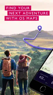
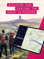
What is os maps: hiking & bike trails app? Create your adventures your way & let OS Maps guide you on stunning routes across the UK & beyond. Get more from the outdoors, with more freedom to explore, more confidence to tackle that next challenge & more adventures along the way. OS Maps is the official app by Ordnance Survey & your guide in the great outdoors.
Why you’ll love using OS Maps:
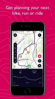
EXPLORE & PLAN HIKES, RUNS OR RIDES
Whether you are planning a walk, hike, run or ride; OS Maps lets you create outdoor adventures with trusted mapping & navigation tools from the experts at Ordnance Survey, Britain’s national mapping service.
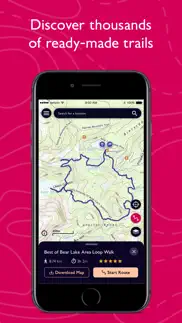
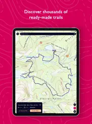
DISCOVER THOUSANDS OF READY-MADE ROUTES
Get outside with curated routes from outdoor experts & organisations such as Trail, Country Walking, Mountain Bike UK, BBC Countryfile & more.
ICONIC OS MAPPING
Subscribe to unlock the detail & accuracy of OS leisure maps including OS Explorer 1:25,000 & OS Landranger 1:50,000 & now with global mapping & topographic mapping for USA, Australia & New Zealand to keep you exploring all over the world.
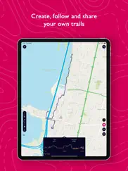
CREATE YOUR OWN ADVENTURES
Best in class route planning & navigation tools mean you can get off the beaten track & explore with more freedom. Plan routes with quick & easy snap-to-path route plotting, then save & share with your friends to plan that next epic day in the outdoors.
NO SIGNAL? NO PROBLEM
Download maps & routes to your phone to view offline, so they’re ready, whenever & wherever you need them. View any part of GB even without signal & export to your GPS device.
UNLIMITED PRINTING
Print copies of all your routes & maps to take with you, so you always have a backup to hand.
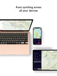
USE ON EVERY DEVICE
Sync your activities between across devices, on desktop, mobile & Apple Watch. On desktop, premium users can use our 3D Aerial Layer & route fly-throughs to see the landscape, terrain & explore in stunning 3D.
TRACK & RECORD ACTIVITIES
Use the activity recording feature to keep a log of your activity history. Follow along, save your activity, review it & turn it into a new route to share & follow again later.
RECOMMENDED BY THE EXPERTS
Ordnance Survey is proud to partner with Mountain Rescue England & Wales, with OS Maps as their recommended app to help you keep on track, & keep safe when heading outside.
TABLETOP 3D
Preview a route before you tackle it, ensure it’s suitable for your level of fitness & avoid any surprises. Our 3D model feature lets you check out your routes from the comfort of your home.
SUBSCRIPTION INFORMATION
OS Maps premium is available through a 1 month or 1 year subscription. Prices are posted in GBP but may vary by country or when converted to local currency. Subscriptions will auto-renew. Payment will be charged to iTunes Account at confirmation of purchase. The subscription automatically renews unless auto-renew is turned off at least 24-hours before the end of the current period. Your account will be charged for renewal within 24-hours prior to the end of the current period, & identify the cost of the renewal. Subscriptions may be managed by the user & auto-renewal may be turned off by going to the user's Account Settings after purchase.
Terms & Conditions at os.uk/termsosmaps
USEFUL INFORMATION
Battery life while using the app can be extended downloading maps offline prior to use, operating in Flight Mode (the GPS will still work) & turning off the screen when not in use. We release updates to all of our apps on an ongoing basis to improve stability & add extra features. Topographic mapping is available for UK (including Northern Ireland), USA, Australia & New Zealand. Your feedback & comments about this app are important to us. Leave a review or use os.uk/contact to get in touch.
*This feature uses Apple's ARKit which requires an iPhone 6s, iPhone SE, iPad 2017, iPad Pro or any later device.
😍 Do you love OS Maps: Hiking & Bike Trails app? Please share your friends!

Please wait! OS Maps: Hiking & Bike Trails app comments loading...
OS Maps: Hiking & Bike Trails 5.0.5 Tips, Tricks, Cheats and Rules
What do you think of the OS Maps: Hiking & Bike Trails app? Can you share your complaints, experiences, or thoughts about the application with Ordnance Survey and other users?

OS Maps: Hiking & Bike Trails 5.0.5 Apps Screenshots & Images
OS Maps: Hiking & Bike Trails iphone, ipad, apple watch and apple tv screenshot images, pictures.
| Language | English |
| Price | Free |
| Adult Rating | 4+ years and older |
| Current Version | 5.0.5 |
| Play Store | uk.os.osmaps |
| Compatibility | iOS 15.0 or later |
OS Maps: Hiking & Bike Trails (Versiyon 5.0.5) Install & Download
The application OS Maps: Hiking & Bike Trails was published in the category Navigation on 10 June 2015, Wednesday and was developed by Ordnance Survey [Developer ID: 569517411]. This program file size is 104.22 MB. This app has been rated by 226 users and has a rating of 4.6 out of 5. OS Maps: Hiking & Bike Trails - Navigation app posted on 11 March 2024, Monday current version is 5.0.5 and works well on iOS 15.0 and higher versions. Google Play ID: uk.os.osmaps. Languages supported by the app:
EN Download & Install Now!| App Name | Score | Comments | Price |
| OS Locate Reviews | 4.7 | 121 | Free |
This release is a major update to the app which improves the ease of use and modernises the look and feel of OS Maps. Major changes include: • Introduction of a 5 bar navigation menu to make it easier to find features • New ‘Home’ tab including shortcuts, recommended partner routes, and learn tutorials • My routes, bookmarked routes, and offline maps now all found in a convenient ‘Saved’ tab • The app can now be viewed in light or dark mode, depending on your system settings Additional new features include: • When viewing a route, you can scroll the elevation chart to see height along the route • On the Maps tab you can choose to see the mapping in full screen mode • When plotting a route, you can now reverse route direction • When searching for a route you can filter by circular or point to point routes • When recording an activity, you can now minimize the recording and continue to use other app features
| App Name | Released |
| NAVER Map, Navigation | 01 May 2009 |
| EVgo EV Chargers | 17 October 2017 |
| Premium Parking | 22 October 2013 |
| Circuit Route Planner | 22 March 2017 |
| Electrify America | 03 June 2019 |
Find on this site the customer service details of OS Maps: Hiking & Bike Trails. Besides contact details, the page also offers a brief overview of the digital toy company.
| App Name | Released |
| GoSkyWatch Planetarium | 31 January 2019 |
| Light Pollution Map | 20 September 2020 |
| Rule Master | 04 April 2022 |
| MilGPS | 01 December 2010 |
| Los Angeles Zoo - LA ZooMap | 10 May 2022 |
Discover how specific cryptocurrencies work — and get a bit of each crypto to try out for yourself. Coinbase is the easiest place to buy and sell cryptocurrency. Sign up and get started today.
| App Name | Released |
| 28 April 2011 | |
| Amazon Shopping | 03 December 2008 |
| TikTok | 02 April 2014 |
| Ralph Lauren | 08 November 2021 |
| Snapchat | 13 July 2011 |
Looking for comprehensive training in Google Analytics 4? We've compiled the top paid and free GA4 courses available in 2024.
| App Name | Released |
| Geometry Dash | 13 August 2013 |
| Plague Inc. | 25 May 2012 |
| Suika Game-Aladdin X | 06 March 2024 |
| AutoSleep Track Sleep on Watch | 19 December 2016 |
| Earn to Die 2 | 20 November 2014 |
Each capsule is packed with pure, high-potency nootropic nutrients. No pointless additives. Just 100% natural brainpower. Third-party tested and validated by the Clean Label Project.
Adsterra is the most preferred ad network for those looking for an alternative to AdSense. Adsterra is the ideal choice for new sites with low daily traffic. In order to advertise on the site in Adsterra, like other ad networks, a certain traffic limit, domain age, etc. is required. There are no strict rules.
The easy, affordable way to create your professional portfolio website, store, blog & client galleries. No coding needed. Try free now.
OS Maps: Hiking & Bike Trails Comments & Reviews 2024
We transfer money over €4 billion every month. We enable individual and business accounts to save 4 million Euros on bank transfer fees. Want to send free money abroad or transfer money abroad for free? Free international money transfer!
Really useful. I got this app just before starting out on a week-long walking holiday and was a little unsure about it as I love paper maps . It was incredibly useful. As we walked in the rain and on top of windy cliffs it was much easier to use the app than do battle with a paper map. It can be used offline so internet connection isn't vital. The image quality is excellent. It doesn't get blurry when you zoom in or out. I like the feature that shows you exactly where you are and that you can record your routes and distances. The only slight issue I have with it is if you have it set to record your route and then try to move the map to see where you are heading (or zoom out) the map automatically centres back on your current location. But all in all a great addition to the OS range.
Terrific app. This app does so much in a easy to learn format. I highly recommend it!
Love in the USA. I use this app all the time for my walking in Washington State. All the trails are there. App works amazing. Gaia GPS went downhill after Outside bought it. OS explorer is great!
Don’t see how to integrate with OS hiking guides. I’m a big user of Ordnance Survey hiking guides, particularly the Pathfinder series, but don’t see a way to integrate these routes into the App. Am I missing something?
Fails to retrieve country settings. As of 2022-02-08, my copy can’t allow setting up account—with which to add more detailed maps—because “failed to retrieve country settings.” Blah. As of 2022-02-13, now won’t even log me in because “failed to retrieve email server,” or soemthing. My email server is working fine. I am suspecting that this thing only works for people in the UK.
Map download. Although you can download actual OS maps, which is good: these maps take a very long time to download, in the US 24 hours; you have to scroll to map area to download, so when downloading adjacent areas there is likely to be overlap, so you download overlap areas twice;
Keep on Trekkin'. We use OS Maps app all across the UK @TrekEpic, love it!!! Can't wait for our next walk!
Good App, but don’t subscribe in app. Like this app for the rights of way and download map feature (which worked fine for our trip), but subscribe through the website and not in the app. A one month subscription through the app ran out on the last day of the month (after only 2 weeks) and not after 30 days. The in app subscription also didn’t reflect in our account on the website. Subscribing instead through the website also works for the app and it lasts for the appropriate amount of time from activation (you might also be able to find a discount code for it).
Released with fatal bugs. In July of 2016 I used this app for walks in the Yorkshire Dales. I had planned the trip carefully, researching walk routes on the Internet, and downloaded about a dozen offline maps, a key feature of the app, designed so you can view a map in a wilderness area without data connectivity. The maps saved ok, but I discovered when I tried to use them, that if I loaded a saved route on top of an offline map, it would crash immediately.. On my first walk I had to abandon the app altogether and use a paper map. Later I discovered I could use the app if I loaded the map I needed for the upcoming walk using wifi in my hotel. As long as I didn't save it, it would persist in cache and I could load saved routes on top of it. So I finished the trip using the App that way. That's why a 2* rating. When I contacted customer support after my trip to report the problem, they admitted this was a known bug if you save more than "3 or 4" offline maps.
Not serious about safety. The app developers are pretty casual with their users’ safety. Offline maps are an important safety tool on a hike and if you can’t rely on them being available (or if they’re not available at all zoom levels), it can be a risk to use them on a hike. Given that this is basically a government funded endeavour, it’s terrible how careless they are.
Doesn’t work. Period.. All you get on trying to log in to the iPhone/iPad app is “Unknown error occurred. Please try again.” Really helpful. I paid for the Premium version so that I could import routes. Just getting the login working on their site was a chore; their domain and session handling seems a mess. And now I find the iPhone app is effectively useless. Can I have my money back please?
Must have for hiking in the UK. If you’re going hiking in the UK and not taking this app on your smartphone then you are a fool. Definitely worth the cost of the premium version to get access to the detailed maps and offline maps. OS maps always had amazing accuracy and detail - now you can use gps on your phone to see exactly where you are among all that detail. Great for planning free form hikes to get you off the beaten path. Only thing the app can’t tell you is the condition of the trail or footpath you are going to hike on - huge clumps of stinging nettles are a real thing - but you can use the app to replay your hike on the fly to avoid whatever you encounter that you don’t want to deal with. All this for less than the cost of a single paper map - it’s a bargain!
Major technical issues syncing to iPhone and I Pad. When I originally installed the apps and upgraded to Premium, everything worked fine. I logged out, but could never log back in with my premium subscription, both on the website and on the smart devices. I was finally able to log back on to their website but only by changing my password, which is ridiculous. And when I used the new password on my iPhone and iPad, in both cases I received the message that an unexpected error had occurred. Technical support did their best to help but the issue remains unresolved. There’s another feature of the app that is very annoying (this was before all my technical issues). The screen has a window with the option to start navigation. I only wanted to look at the route, not navigate. Unfortunately this window takes up a significant part of the screen, blocking a large part of the map. For some unknown reason, you can not close this window, and tech help said that the app developers aren’t currently going to change it. All in all, it’s a great app when it worked for me, and most people don’t appear to have had the problems I’ve experienced. I hope that tech people read this and do some more development work.
Very good. Missing one basic thing!. I use this app whenever visiting family in the UK, for hikes and runs as it points out locations of historical interest as well as footpaths in the countryside. I’m back for the first time in 4 years (thanks covid) and just in time to try the new snap to path feature which is great! Wow! The one thing missing is that I can’t save locations the map and to a list. I’d love to be able to save “mum’s house”, as well as other destinations I’d like to visit without having to plot a route. Love OS, they’re great maps!
Offline maps are buggy. Downloaded a couple of maps from purchase of paper versions. Zooming causes the map to be truncated. Can’t be relied upon. Test before you leave.
Quits repeatedly with large custom offline maps. Created a custom map of most of Pembrokeshire (250K) for an upcoming hike. Once it finished downloading, I zoomed in and out, scrolled, etc. It only took a few seconds for OS Maps to quit. I tried again with similar results. A separate custom online map of SE Wales had the same trouble. I had fewer problems with paper map downloads (OS maps that have a digital activation code). This makes me think that OS Maps was not thoroughly tested with large offline maps (>250K). I will make sure that I carry paper maps for now.
Doesn’t work when connected to the internet. Update. The app works great with no internet connection. Disable mobile data for the app and it works great. Having purchased paper maps, I’ve used this app to download the off-line version. The app continually requires me to re-login, and I frequently have to re-download, or at least verify the download, before I can use the maps. Horribly flaky behaviour.
Just terrible. I downloaded a paper map, then zoomed in on it, but it failed to show up. I close & reopen map; still not showing. Then I kill the app, reopen, and finally the map shows on zoom in. Really this app is poorly map. I think I will move to AllTrails instead. OSM is so much better now. Previous complaint: drove to remote location with no mobile phone to do a hill walk. Opened the app and nothing worked: it had logged me out and refused to show my downloaded map. There I was, in the wilderness, and no electronic map! Thankfully, I brought paper map. This app is useless to me if it requires mobile data to operate on hill walks!
Lots of fun!. For armchair travelers and walkers too.
Did you know that you can earn 25 USD from our site just by registering? Get $25 for free by joining Payoneer!
“Premium” topo has a long way to go. Australian “premium” topo maps appear to be a low res scan which does not zoom without terrible pixelation. Certainly not worth the subscription and nothing like the quality of the UK version. ViewRanger is a better option at the moment for Australia
Not worth it!. Downloaded and signed up. What a waste not even one trail in my area. And found only one in the whole Aus. Waste of time! Deleting and canceling the subscription!
Rubbish!. Why would I pay for a subscription when I have no idea what sort of quality I can expect?
Plagued with problems, poor support. This app has great potential but it just doesn’t work. I can’t view routes I have created nor can I view routes uploaded from gpx files. Support is so slow as to be worthless. I am a Premium member which means I subscribe to all their features. That gets you an app that doesn’t work and support that takes days to answer. Why bother. Worse than the cost of the Premium membership is the amount of time wasted trying to get simple things to work. It should be clear by now that I am not a happy user and recommend people to steer clear. I also use AllTrails. It works. I’ve never used AllTrails support, I’ve never needed to.
Not worth it!. I got suckered into paying for the app, it doesn’t even show available riding trails in my area. They are sign posted by the local council but this app doesn’t recognise them. Absolute waste of money!
Not for AU Vic. Doesn’t really have anything listed, there’s quite a few well known walking tracks in my area and none appear on the map.
Poor quality maps. The maps were so low resolution it was pointless keeping the app. It’s a shame because it would otherwise be so useful.
Useless for Australia. Absolutely useless for Australia. Zero maps in SEQ, complete waste of time and money.
“Premium”. The initial app was very promising, so I upgraded to access “premium” topographical mapping. Unfortunately this premium map is an embarrassingly bad image that couldn’t even be used for planning long distance cycling or driving. So disappointing given the fantastic quality I’m used to from OS in the UK. Such a shame as the base app is good Update: several weeks later the “premium” maps haven’t been updated, and I’ve had no response to emails to customer services. Star rating reduced commensurately.
My subscription disappeared. I came on a walking holiday, relying on the app for navigation. After day 3, the app “forgot” my Premium subscription so it won’t show me the leisure maps. I am so angry! It’s Sunday and I can’t even talk to their support. What a joke.
Buggy. Premium subscription very buggy. Says you need to download maps but won’t let you download when you have it. So it is useless
Don’t rely on this for Australia - could be a death sentence. For the new Australian service - I would suggest steering clear of this app at least until they get their act together. It’s patchy at best and poorly constructed without true bushwalking maps being included. There’s plenty of bushwalking guides and maps available, including digitally, and I suggest looking at those instead. Getting lost in the Australian bush can be a death sentence, and by putting out a beta product with poorly constructed maps loaded on a battery-powered device, is just asking for trouble. Let’s hope the worst doesn’t occur. Coming from an experienced wilderness warrior - be prepared and stay aware.
Can’t Rely on This App. We subscribed to the maps for a month long walking holiday in UK. Downloaded maps disappeared, their update went badly with many bugs. Could be fatal, so carry a hard copy map.
Downloadable maps don’t work. No help from OS to resolve.. Firstly the codes on the paper UK explorer maps didn’t work. After chasing it up with OS, the downloads were added to my app account. Then the downloads triggered a message “the map failed to load because the style can’t be loaded.” They advised be to uninstall, reinstall, redownload. Same issue again. When I contacted OS they said they would get technical services to look into it. A week later I got an email saying they couldn’t recreate the issue and couldn’t fix it, in spite of screenshots being provided showing it is a problem. Waste of time and clearly false advertising when they say includes mobile download on the front of their maps. Really poor service.
Imagine you at your best. All the time. Picture yourself at your sharpest and most productive. Your most alert and focused. Your most lucid, creative and confident. At work. At play. In every area of your life. Add Mind Lab Pro® v4.0 to your daily routine and uncap your true potential. Buy Now!
Adsterra is the most preferred ad network for those looking for an alternative to AdSense. Adsterra is the ideal choice for new sites with low daily traffic. In order to advertise on the site in Adsterra, like other ad networks, a certain traffic limit, domain age, etc. is required. There are no strict rules. Sign up!