Elevation Tracker App Reviews
Elevation Tracker App Description & Overview
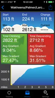
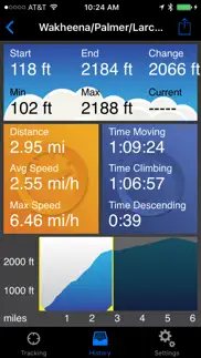
What is elevation tracker app? Elevation Tracker is a fitness tracking app with a particular emphasis on climbing and descending. It tracks and displays the following info:
- Basic info like time, speed and distance
- Current elevation and accumulated climbing and descending amount
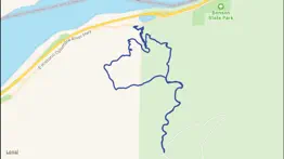
- Elevation profile and route map
- Current heart rate and time spent in four training zones (if paired with an Apple Watch or chest strap)
When paired with an Apple Watch, Elevation Tracker really shines, displaying all this info (except the elevation profile and map) in an easy-to-read format. We haven't seen another fitness app that puts this much info onto your wrist for detailed tracking during your activities.
When you finish an activity, you can save it to your history, email route summaries and profile images, send GPX data to other applications, or download refinements from an online elevation database. You can even drag range selectors onto the profile to view the stats for just one section of your route.
Elevation Tracker uses GPS to determine elevation. GPS is not as accurate for elevation as it is for location, but over the course of an outdoor activity, the results are still quite useful. Elevation Tracker is not designed for indoor (stair climbing) or stationary (treadmill) use.
Elevation Tracker works in the background or with your device locked, and can run alongside other fitness apps you might be using. We routinely use this app for real-time display, another app for social sharing and a third for emergency tracking, all at the same time. Continued use of GPS running in the background can dramatically decrease battery life, but newer smartphones have enough capacity to handle this for the duration of an activity.
>>> If you have a problem or a suggestion, please contact me before writing a bad review. My response capability is limited if you publish your complaints in a review, but I respond promptly to all emails. <<<
😍 Do you love Elevation Tracker app? Please share your friends!

Please wait! Elevation Tracker app comments loading...
Elevation Tracker 2.6.5 Tips, Tricks, Cheats and Rules
What do you think of the Elevation Tracker app? Can you share your complaints, experiences, or thoughts about the application with Arlo Leach and other users?

Elevation Tracker 2.6.5 Apps Screenshots & Images
Elevation Tracker iphone, ipad, apple watch and apple tv screenshot images, pictures.
| Language | English |
| Price | $2.99 |
| Adult Rating | 4+ years and older |
| Current Version | 2.6.5 |
| Play Store | com.arlomedia.elevationtracker |
| Compatibility | iOS 8.0 or later |
Elevation Tracker (Versiyon 2.6.5) Install & Download
The application Elevation Tracker was published in the category Navigation on 15 July 2011, Friday and was developed by Arlo Leach [Developer ID: 353281976]. This program file size is 5.33 MB. This app has been rated by 6 users and has a rating of 2.3 out of 5. Elevation Tracker - Navigation app posted on 24 January 2020, Friday current version is 2.6.5 and works well on iOS 8.0 and higher versions. Google Play ID: com.arlomedia.elevationtracker. Languages supported by the app:
EN Download & Install Now!| App Name | Score | Comments | Price |
| BandHelper Reviews | 4.2 | 87 | Free |
| Mouth Harp Reviews | 3.2 | 4 | Free |
| BandHelper Reviews | 1 | No comment | Free |
| Set List Maker Reviews | 1 | No comment | $19.99 |
| Autoharp Reviews | 3.9 | 10 | $0.99 |
- Fixed a crash on launch when paired with an Apple Watch.
| App Name | Released |
| Bonjour RATP | 14 May 2012 |
| EVgo EV Chargers | 17 October 2017 |
| Google Maps | 12 December 2012 |
| OnX Backcountry Trail Maps GPS | 09 December 2020 |
| Speedometer Simple | 18 November 2014 |
Find on this site the customer service details of Elevation Tracker. Besides contact details, the page also offers a brief overview of the digital toy company.
| App Name | Released |
| Bronx Zoo - ZooMap | 16 May 2021 |
| Jacksonville Zoo - ZooMap | 25 October 2021 |
| Tactical NAV | 14 February 2011 |
| WakeWatch | 31 March 2016 |
| StarPilot | 03 March 2010 |
Discover how specific cryptocurrencies work — and get a bit of each crypto to try out for yourself. Coinbase is the easiest place to buy and sell cryptocurrency. Sign up and get started today.
| App Name | Released |
| Google Maps | 12 December 2012 |
| Snapchat | 13 July 2011 |
| Ralph Lauren | 08 November 2021 |
| 09 October 2009 | |
| 12 February 2019 |
Looking for comprehensive training in Google Analytics 4? We've compiled the top paid and free GA4 courses available in 2024.
| App Name | Released |
| Suika Game-Aladdin X | 06 March 2024 |
| Shadowrocket | 13 April 2015 |
| 75 Hard | 19 June 2020 |
| Poppy Playtime Chapter 1 | 08 March 2022 |
| Slay the Spire | 13 June 2020 |
Each capsule is packed with pure, high-potency nootropic nutrients. No pointless additives. Just 100% natural brainpower. Third-party tested and validated by the Clean Label Project.
Adsterra is the most preferred ad network for those looking for an alternative to AdSense. Adsterra is the ideal choice for new sites with low daily traffic. In order to advertise on the site in Adsterra, like other ad networks, a certain traffic limit, domain age, etc. is required. There are no strict rules.
The easy, affordable way to create your professional portfolio website, store, blog & client galleries. No coding needed. Try free now.
Elevation Tracker Comments & Reviews 2024
We transfer money over €4 billion every month. We enable individual and business accounts to save 4 million Euros on bank transfer fees. Want to send free money abroad or transfer money abroad for free? Free international money transfer!
Good. Pretty accurate
Good app, needs work. App elevation if off by more than 100 feet. If I go up a mountain and back down it reports a elevation much higher than I started with. Doesn't truly support background app refresh. App constantly crashes or has to be reopened. Doesn't always track elevation and it would be able to use the up/down buttons on the Pebble to look at elevation gain, start/max elevation. Thanks, Mike
Works Great. I walk city streets and hills and this works really well. Easy to read and it will also display my route. Pretty accurate too.
Not working. Basically it does not work. Waste of money.
Not worth even $1.99. This App can't even tell you what elevation you have claimed or descended during a hike or ski. You can not get a reading unless you stop the tracking. If you hike a 1100ft peak and track starting at the trailhead returning to the same trailhead your elevation reading gained is ZERO! Duh! Who needs an app for that. It does not provide cumulative number of feet or meters actually climbed. Get a basic altimeter and do your own calculating. The app is a waste.
Doesn't seem to work at all. Won't detect movement. Reported 11' Elevation change walking in my living room (but still did not detect I was moving) tested several times. No luck at all. IPhone 5 latest iOS release.
DO NOT BUY THIS APP. This app is completely inaccurate for tracking elevation. It does not actually track elevation well. I do not recommend this app.
Did you know that you can earn 25 USD from our site just by registering? Get $25 for free by joining Payoneer!
Imagine you at your best. All the time. Picture yourself at your sharpest and most productive. Your most alert and focused. Your most lucid, creative and confident. At work. At play. In every area of your life. Add Mind Lab Pro® v4.0 to your daily routine and uncap your true potential. Buy Now!
Will not work. Crashes while booting
$2 for this $2 for that. If you want the full capabilities of this tracker you gotta pays for all kinds of "extras" What I want to know is which is better as a Data Source:GPS or NASA.
Adsterra is the most preferred ad network for those looking for an alternative to AdSense. Adsterra is the ideal choice for new sites with low daily traffic. In order to advertise on the site in Adsterra, like other ad networks, a certain traffic limit, domain age, etc. is required. There are no strict rules. Sign up!