QLDTraffic App Reviews
QLDTraffic App Description & Overview
What is qldtraffic app? QLDTraffic is the official source of live traffic and travel information from the Queensland Government. It lets you check traffic conditions and plan your journey before you drive.
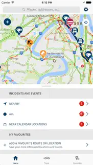
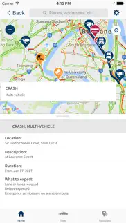
Managed by the Department of Transport and Main Roads, QLDTraffic provides information on road conditions throughout Queensland, including crashes and hazards, road closures and restrictions, roadworks and special events. The app also provides access to web cameras that relay near real-time traffic imagery.
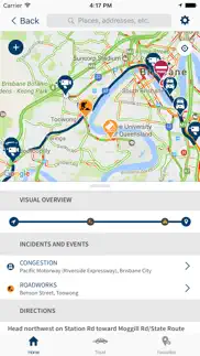
Add your favourite routes to the app, like the trip to the office or a car journey to school, and QLDTraffic will inform you of traffic issues on the way. It’ll even send you personalised push notifications if something happens on your favourite routes, so that you’ll know before you go.
FEATURES
· Save favourite routes and places to receive personalised traffic alerts as push notifications
· See live traffic alerts and events on a map
· Filter traffic alerts to see:
o What’s happening on your routes or around your current location
o Incidents near your calendar events (if you’ve set a location for the event)
o Crashes, flooding, and hazards
o Road closures and restrictions
o Roadworks and special events
o Traffic flow and congestion
o Traffic web cameras
· Add a route by searching for a way to drive
· Use travel mode while you’re on the move to get live traffic alerts throughout your journey
o Travel mode includes audio announcements, so you can continue to pay attention to the road.
· Add custom routes by recording your trip in travel mode
Please note: Continued use of GPS running in the background can dramatically decrease battery life.
😍 Do you love QLDTraffic app? Please share your friends!



Please wait! QLDTraffic app comments loading...
QLDTraffic 1.9.53 Tips, Tricks, Cheats and Rules
What do you think of the QLDTraffic app? Can you share your complaints, experiences, or thoughts about the application with Department Of Transport And Main Roads and other users?

QLDTraffic 1.9.53 Apps Screenshots & Images
QLDTraffic iphone, ipad, apple watch and apple tv screenshot images, pictures.
| Language | English |
| Price | Free |
| Adult Rating | 4+ years and older |
| Current Version | 1.9.53 |
| Play Store | au.gov.qld.tmr.traffic |
| Compatibility | iOS 9.0 or later |
QLDTraffic (Versiyon 1.9.53) Install & Download
The application QLDTraffic was published in the category Navigation on 08 February 2017, Wednesday and was developed by Department Of Transport And Main Roads [Developer ID: 919723337]. This program file size is 35.84 MB. This app has been rated by 1 users and has a rating of 1 out of 5. QLDTraffic - Navigation app posted on 19 June 2026, Friday current version is 1.9.53 and works well on iOS 9.0 and higher versions. Google Play ID: au.gov.qld.tmr.traffic. Languages supported by the app:
EN Download & Install Now!| App Name | Score | Comments | Price |
| EIT Forum Portal Reviews | 1 | No comment | Free |
| Verifier for Digital Licence Reviews | 1 | No comment | Free |
| Queensland Digital Licence Reviews | 1 | No comment | Free |
| Translink Reviews | 1.2 | 4 | Free |
In this release: Removed SurveyMonkey prompts and menu, and fixed some bugs.
| App Name | Released |
| Earnify | 22 May 2024 |
| Bonjour RATP | 14 May 2012 |
| Neshan Map | 04 May 2023 |
| DC Metro and Bus | 19 November 2012 |
| Premium Parking | 22 October 2013 |
Find on this site the customer service details of QLDTraffic. Besides contact details, the page also offers a brief overview of the digital toy company.
| App Name | Released |
| FlightReady E6B | 10 October 2015 |
| Solocator - GPS Field Camera | 09 December 2012 |
| Ski Tracks | 05 April 2010 |
| Speedometer 55 Pro. GPS kit. | 10 June 2012 |
| Strike and Dip | 30 October 2009 |
Discover how specific cryptocurrencies work — and get a bit of each crypto to try out for yourself. Coinbase is the easiest place to buy and sell cryptocurrency. Sign up and get started today.
| App Name | Released |
| Messenger | 09 August 2011 |
| YouTube TV | 05 April 2017 |
| Google Maps | 12 December 2012 |
| WhatsApp Messenger | 03 May 2009 |
| Ralph Lauren | 08 November 2021 |
Install the Giftmio extension for smart shopping. Get notified about cashback opportunities, activate cashback in one click, and save money on purchases.
| App Name | Released |
| Balatro | 26 September 2024 |
| Earn to Die 2 | 20 November 2014 |
| RadarScope | 12 February 2019 |
| Monash FODMAP Diet | 17 December 2012 |
| CloverPit | 17 December 2025 |
Each capsule is packed with pure, high-potency nootropic nutrients. No pointless additives. Just 100% natural brainpower. Third-party tested and validated by the Clean Label Project.
Adsterra is the most preferred ad network for those looking for an alternative to AdSense. Adsterra is the ideal choice for new sites with low daily traffic. In order to advertise on the site in Adsterra, like other ad networks, a certain traffic limit, domain age, etc. is required. There are no strict rules.
Keep personal info private, avoid scams, and protect yourself online with AI-powered technology.
QLDTraffic Comments & Reviews 2026
Did you know that you can earn 25 USD from our site just by registering? Get $25 for free by joining Payoneer!
Embarrassing!. I have such low expectations when I see government / councils try to invent anything tech or new & I wasn’t let down this time. Clunky, slow & really amateur. Can’t even get the maps to load the details before the next APPLE OS has been realised (jokes) but you get the idea. Waze uses a bit of power but leaves app in the dust. Waste of time!
Keeps sending me through flooded roads. Why doesn’t the app route you around a closed road? Why on earth would I want to go on a journey and wait for a flood to go down for a few days before continuing if there is any way possible to avoid it?
Decent app. It’s alright overall like it has some problems navigating and loading but it dose show the road works and stuff. It’s good but can still improve
Rubbish. This app is absolutely useless. I am currently stuck in Mackay due to flooding over the Bruce Hwy which is closed in several places between Calen and Prosepine yet it shows nothing on the app.
Too slow with the information. Very quick to put up road closures on the app, extremely slow at putting them down. The information during flooding events is far too slowly updated. A review by another user from three years ago says the same thing and the developer has stated it is a top priority to be fixed. This has clearly not been the case
No transparency. There has been no response to repeated accusations of TMR staff posting positive reviews for their own app here. Feel free to comment an answer on this one.
Crashed on first use. I wasn’t even able to enter a destination it crashed on one attempt, showed me a sad cloud with try again on another & did nothing on another attempt. App deleted maybe iron out the bugs first 😡
Bad app. Pity queensland did not purchase an app from the developer who made the NSW app , at least it would have been useable then.
Need serious improvements. Just downloaded the apps today to check the flood affected roads. When using the map, it seems ok. However when trying to plan a route , even for a 5 min drive, the apps doesn’t work. Has to revert to IPhone map or Google map.
Map. Ridiculously small map. Should be able to see the whole state on a full page similar to NSW incidents app. Very disappointed.
Awkward and clunky app. Have been using live traffic Nsw and found it easy to use and read. This app requires iPad to be held awkwardly and visuals do not fill screen. Find it outdated and is not user friendly compared to other similar apps. Look elsewhere.
Crashes on ipad Air and iphone 7+ constantly. Cant search for any address as it just wont stay open long enough to actually search. Same issue on both devices and both have ios13.2.3. Cant honestly be the only one im sure 🤷♀️ PS hasn’t been updated since August 2017 - assume they lost interest. Which is sad have a few recommendations rather then managing your own maps why not merge your maps with google? Then you can utilise what they already provide but if you offer the functionality to report incidents while they use your app I think it would be more efficient and definitely help you provide an upto date service rather then telling people it could take days to show up. The data would definitely assist you to also know what roads are causing the most issues I would have thought too. Also manage emergency services quicker too?? Could also partner up with the emergency services app too?? Anyways if you need some direction id be happy to assist 👍
A Garbage. Completely useless when you need it, like all Australian government websites and apps, i am sure our government spent few million dollars on this app from tax payers pocket to make this rubbish app when they can just update road conditions on the google map easily and free.
Awful. This app is absolutely awful. There was severe traffic congestion on the Bruce Highway this afternoon the app told me my route from Narangba to Buderim would be 55 minutes. I joined the Bruce highway confident the accident must have been cleared only to sit in a jam for hours. It’s pathetic. Use this app at your peril.
Crashes. I’ve tried to use the trip recording feature to save favourite routes a few times now and the app just crashes (closes itself) after about an hour or two of the journey.
Please fix. Please update , roads open but on here they’re still closed.
Hasn’t been updated since 2022…. Current flooding road closures are not in the app. Most recent is October 2022, which doesn’t exactly help anyone given the current situation. Will the app be updated any time soon?
Freezes. Terrible app that freezes. Can’t scroll or move to another place to check roads.
Dangerously inaccurate. Info rarely updated, shows roads closed from months ago that are not closed and doesn’t show current closures due to floods. Should be removed from access.
Please! Please! Please update!. This app is basically useless as it is not updating as to what roads are NOT open during the last few days/weeks of flooding! If it’s flooded, forget it we are being told Ad nauseam but if you updated what roads are flooded sensible people would either avoid the flooded areas or stay home! Sorry but you are not encouraging people to act/drive safely at all!!!
Irregular updates. Downloaded because a major highway access cut off our main route to town. Irregular updates, better information provided by google maps traffic overlay.
To slow. Useless app doesn’t even report flooded roads even after they have been closed for over 24hrs pathetic
Totally useless app. None of the functions in this app work. Tried to type in search boc and it keeps freezing. Why you need access to my calendar? Spy on my life and hack my phone? This app has hardly any features. Sack the all developers of this app and hire someone who knows how to develop properly functioning app
Utterly useless. Crashes randomly for no reason. Tried to use it to check on flooding around brisbane but it just fails to even plan a journey, let alone show info on a map. And it uses Google for journey planning.. so why not just use Google maps? Rubbish
Lousy on an iPad. Hi tried this app may be fine on a phone but on my iPad Pro it windows to a small mobile size screen that I cannot find any way of fixing. It does work on the iPad but acts as if on a iPhone too much text not yes of available iPad screen
Misleading road information during disasters. During disasters when road conditions change quickly, the app does not seem to update frequently enough to reflect what is actually happening. When entering a destination, it sometimes shows routes as clear even when roads are closed or impacted. Because of this, I no longer rely on the app, even though emergency services recommend it during disasters. I’ve personally found Google Maps to be more reliable, as users can report road closures and hazards in real time. I can also find flood cameras and other useful information through other apps. Unfortunately, this app has become mostly useless for me. It feels very clunky and outdated, almost like it’s running on software from 20 years ago. I wish government agencies would reconsider recommending an app that can be misleading during emergencies. This app has potential, but it needs major improvements to its reliability, update speed, and overall usability.
Slow to update. Road closures seem to update reasonably quick. But road reopening are very slow to update. Much better using google maps
Terrible. Hey Admin, do you even check user reviews? This app is a complete rubbsh—its design, functionality, and features are all a mess. Who on earth did you hire to build this train wreck?
Slow, lacks info & “only” TMR. The road closure info needs to be updated more often in a rapidly-changing situation such as a flood event. The map is slow to use: clunky to move and zoom in or out. There are different coloured stripes on roads, which presumably indicate something about their accessibility, but there is no explanation anywhere in the app or online about exactly what the colour codes mean. Finally, when using the function to search for a specific road, MOST roads are “not TMR controlled roads” and therefore there is no data available about them. Can you really not get your collective selves together in 2022 and stop splitting hairs over who is responsible for what and just give us the info we need?!!
Mackay/Whitsunday Traffic/Flood Cameras. Still no flood cameras for Mackay/Whitsunday Region. What is going on TMR? Apparently nothing :( poor response from TMR blaming “remoteness” what the? The cameras along the Bruce Highway near Proserpine like Myrtle Creek and Goorganga Plains etc are not remote and are near mobile towers. Where did you install the other cameras? Llanarth? Seriously TMR Mackay is the worst district to live in, they are terrible compared to other districts.
So useful. Brilliant for travel in FNQ when keeping a eye out for possible flooding. Great to be able to save a route and check it.
Old. If you are looking for old information about road closures or crashes this is the spot. There’s no current information on this site it’s next to useless.
Outdated information. The map is cluttered with outdated information. For example, Hazards in Broken Hill, last updated two months ago. Also, Eungai Creek, updated 4 weeks ago and dated 17 March. It’s now June.
Terrible App. This application is not working properly. The links to cameras work but the travel plan feature does not. Spent 10-20 mins trying to check for road closures during a heavy rain event but would not even load. Deleting this app and is a waste of tax payers money.
Needs flood camera. Love using the website as it shows the flood cameras on the bridges. Was hoping that the app would also show feature this but it doesn’t.
What is the point of this app???. This app doesn’t do anything at all. Doesn’t show you anything. It is useless? I don’t understand the point. Most pointless app I’ve ever downloaded. Does Not Show Rest Areas Either.
Useless !. Totally useless app ! It does not synchronise with the data presented on their website, which is also out of date and meaningless. I'm deleting it.
Accuracy is not timely. No regular updates. To be useful, this information needs to be as close to ‘real time’ as practical. One example that affects me is the roads around Thargomindah and Yowah areas are still shown as closed or 4WD only which was the situation October 2022 - that’s 20 months ago.
Slow to update. Difficult to navigate, the filter function is virtually useless. Important information about road closures is sometimes days old and inaccurate. People are better off joining a Facebook page for real time updates.
Doesn’t work on iPhone. App is unable to load local warnings, unable to plan a trip from surfers to Rockhampton. What’s the point ?
Waste of Space.. Opens on a small phone sized screen on an iPad. This makes expanding and reading maps difficult, particularly for older people.
Urban Use Ok. The map becomes very cluttered if zoomed out to view a large area when traveling out west
Hopeless. Never up to date. Not worth having as the app is never updated with latest road information even when there is a major incident on a major freeway like a traffic accident. If the app worked like the NSW live traffic app with constant updates of incidents and indicating incidents in current location it would be a whole lot better.
No use to man nor beast!. The app frequently hangs and is painfully slow to zoom and move around. Still shows the road as being closed to Lark Quarry…but we drove it easily today. Was last updated 3 days ago which is just not good enough. Frequent updates and better local knowledge of roads required!!!
Difficult to navigate. I got this app to check for the quickest route. I found it difficult to navigate and doesn’t show the estimated travel time on the map itself. Google maps is easier to quickly choose the best route
Rest areas. I can not find rest areas which on your web site says should be on this app
Always Refreshing. The app gets annoying sometimes because it’s always refreshing every 3 secs. Also when things have happened like floods, vehicle accidents and so on the app doesn’t need to be updated every 3 secs due to long delays. How about every 10mins as people normally find out before the app finishes there 2000th update when a road opens to 4WD only and then conventional vehicles etc.
Worst app of all time. Would honestly be easier to jump in the car and try every single route until you find one not closed. Why can’t you just filter the map by road closures ? Totally useless app and website.
Up to date road report for western Qld. A very helpful tool for travel during the wet season in northwest Qld. Seemed to be updated with accurate information regularly.
Useless. Given the recent situation with the weather in and around Brisbane, it is essential that clear concise information be given about flooded areas and routes. The App as it currently stands is slow and buggy and is very hard to navigate. It doesn’t seem to display the full areas of flood closures and even turning roadworks off, some closures are still noted as roadwork related, not flooding! An absolute mess compared to the NSW live traffic app. Perhaps an agreement could be reached enabling Queensland to utilise NSWs technology as currently both the website and app are not for for purpose, especially on mobile devices.
Imagine you at your best. All the time. Picture yourself at your sharpest and most productive. Your most alert and focused. Your most lucid, creative and confident. At work. At play. In every area of your life. Add Mind Lab Pro® v4.0 to your daily routine and uncap your true potential. Buy Now!
Adsterra is the most preferred ad network for those looking for an alternative to AdSense. Adsterra is the ideal choice for new sites with low daily traffic. In order to advertise on the site in Adsterra, like other ad networks, a certain traffic limit, domain age, etc. is required. There are no strict rules. Sign up!