Wildfire - Fire Map Info App Reviews
Wildfire - Fire Map Info App Description & Overview
What is wildfire - fire map info app? Download the most comprehensive Wildfire app for iOS.
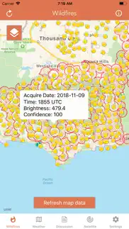
CURRENT WILDFIRES
- MODIS Thermal Satellite Fire Detection
- VIIRS IBAND Fire Detection
- MODIS + VIIRS Spot Details
- Fire Weather Outlook: Days 1 - 8
- Large Fire Points
- Dry Thunderstorm Fire Weather Outlook
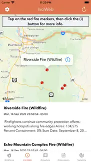
- National Fire Incident Reports
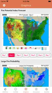
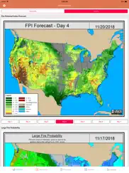
- Fire Potential Index: 7-day Forecast
- Large Fire Probability
- Fire Danger Rating
- Expected Large Fires per PSA
- National Significant Fire Outlook: 4-months
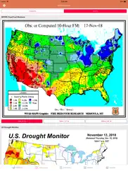
- NFDRS Dead Fuel Moisture
- US Drought Monitor & Index
HAZARDOUS WILDFIRE CONDITION ZONES
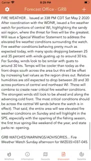
- Detailed NOAA discussion
GOES-16 SATELLITE IMAGERY ANIMATIONS
- Regional zones (CONUS)
* Available for iPhone and iPad with single purchase *
Feel free to contact me at [email protected] if you have any questions.
Enjoy.
😍 Do you love Wildfire - Fire Map Info app? Please share your friends!

Please wait! Wildfire - Fire Map Info app comments loading...
Wildfire - Fire Map Info 1.4 Tips, Tricks, Cheats and Rules
What do you think of the Wildfire - Fire Map Info app? Can you share your complaints, experiences, or thoughts about the application with LW Brands, LLC and other users?

Wildfire - Fire Map Info 1.4 Apps Screenshots & Images
Wildfire - Fire Map Info iphone, ipad, apple watch and apple tv screenshot images, pictures.
| Language | English |
| Price | $0.99 |
| Adult Rating | 12+ years and older |
| Current Version | 1.4 |
| Play Store | wildfires.lwbrandsllc |
| Compatibility | iOS 13.0 or later |
Wildfire - Fire Map Info (Versiyon 1.4) Install & Download
The application Wildfire - Fire Map Info was published in the category Weather on 06 August 2018, Monday and was developed by LW Brands, LLC [Developer ID: 963599018]. This program file size is 9.44 MB. This app has been rated by 1,709 users and has a rating of 4.4 out of 5. Wildfire - Fire Map Info - Weather app posted on 10 April 2025, Thursday current version is 1.4 and works well on iOS 13.0 and higher versions. Google Play ID: wildfires.lwbrandsllc. Languages supported by the app:
EN FR PT Download & Install Now!| App Name | Score | Comments | Price |
| Turkey Call App Reviews | 4.2 | 269 | $2.99 |
| Kentucky 511 Traffic Cameras Reviews | 4.4 | 152 | $2.99 |
| Marine Weather Forecast Pro Reviews | 4.7 | 15,758 | Free |
| Wyoming Road Conditions Reviews | 4.6 | 2,733 | Free |
| North Carolina Traffic Cameras Reviews | 4.5 | 238 | $2.99 |
+ Updated GOES-East imagery to utilize GOES-19, the designated replacement for GOES-16 + Fixed a few minor bugs Thank you for the positive feedback!
| App Name | Released |
| Car.Play Weather Navigation | 20 May 2023 |
| OSHA-NIOSH Heat Safety Tool | 23 May 2017 |
| UV Index Widget - Worldwide | 03 May 2016 |
| Beam Tanning - Get Tan Fast | 13 July 2024 |
| WeatherWise.app | 16 October 2024 |
Find on this site the customer service details of Wildfire - Fire Map Info. Besides contact details, the page also offers a brief overview of the digital toy company.
| App Name | Released |
| RainAware Weather Timer | 29 February 2012 |
| Fishing Times Pro | 18 February 2011 |
| WeatherPro | 10 November 2008 |
| Best Fishing Times | 30 September 2011 |
| My Aurora Forecast Pro | 26 January 2016 |
Discover how specific cryptocurrencies work — and get a bit of each crypto to try out for yourself. Coinbase is the easiest place to buy and sell cryptocurrency. Sign up and get started today.
| App Name | Released |
| Google Maps | 12 December 2012 |
| Gas | 27 August 2022 |
| 09 October 2009 | |
| Wizz - Make new friends | 24 February 2019 |
| 06 October 2010 |
Install the Giftmio extension for smart shopping. Get notified about cashback opportunities, activate cashback in one click, and save money on purchases.
| App Name | Released |
| HotSchedules | 30 October 2008 |
| Bloons TD 6 | 14 June 2018 |
| AnkiMobile Flashcards | 26 May 2010 |
| Monash FODMAP Diet | 17 December 2012 |
| Geometry Dash | 13 August 2013 |
Each capsule is packed with pure, high-potency nootropic nutrients. No pointless additives. Just 100% natural brainpower. Third-party tested and validated by the Clean Label Project.
Adsterra is the most preferred ad network for those looking for an alternative to AdSense. Adsterra is the ideal choice for new sites with low daily traffic. In order to advertise on the site in Adsterra, like other ad networks, a certain traffic limit, domain age, etc. is required. There are no strict rules.
Keep personal info private, avoid scams, and protect yourself online with AI-powered technology.
Wildfire - Fire Map Info Comments & Reviews 2026
Not ready for prime time. Like so many app makers eager to make a fast buck, the developers released this before it’s ready for prime time. There are fires that are showing up on other apps in the south east bay of San Francisco - bit not this app. I’m going to delete this one because it’s just clutter.
Worthless, constantly crashe. Newest version downloaded, tried it on an iPhone and iPad. Crashes, does not offer relative current data. I live 15 miles from a 7,000 acre fire, this app offers no information on it.
Not worth it…. Bad app. Data is confusing and I think these reviews are false. I don’t rate apps unless they are really bad…this is one of those.
Great app. Aside for a few minor tweaks, I find this a very useful app. Highly recommend. Update- developer offers awesome support of the app. I received a very quick response in answer to my emailed questions/comments. ‘Wildfire’ app continues to inform me well, especially this fire season here in California.
Just evacuated from Easy Fire and it’s still not on this map.. I’m just gonna say today this was totally useless and would have been dangerous if I was depending on this app. The Easy Fire has been burning since 6 am it’s now almost 11am and we are still not a blip on this app.
WildFire App. A very useful app so the development team should be pleased as this is a very useful tool in keeping up to date with Wildfires.
App is awesome again!. The last update fixed everything.....Thank You!
Lacks incident feeds. I live in California, app always starts in Australia. We had nearby fire that was not identified. Would not rely on this app as my “go to”. Developer was kind enough to point out that I was running an older version. Update version took care of the problem and added nice features. The ability to move to incident feeds is especially nice. ThNk you
A must for fire prone areas of the country.. I’ve been glued to the Bobcat fire updates on the app for a week. Watching the glow get brighter and my area get smokier. This a great app. The details of where the fire was moving were informative. I didn’t have to wait for updates on TV. I highly recommend the app.
Useful app, but really slow to load. Useful app, but really slow to load
Great resource for national/regional overview. As the app states, the information provided is not detailed enough for operations; however, it has plenty enough detail for someone to keep tabs and make reasonable estimations of regional fire behavior thanks to the forecasts. I use this app to watch the fire season progress while I’m not deployed. I took one star off because the main map is not quite intuitive. I wish when you clicked on the fires it could give more information about them. Also, it would be nice if the map would indicate where the forecasting offices are for people like me who are unfamiliar with them so I can cross reference forecasts based on stations nearest to the fires. A minor gripe, overall I love the app!
Accurate. With the SAT pictures, I think this app has deadly good precision at locating fires and for how long. Works best around WiFi just because there is so much information to be downloaded.
Grateful for the peace of mind provided by this app. This app has been super helpful for tracking the progression of the Kincade Fire in Sonoma County. Thank you for making this information easily available. The ability to hide the legend is great. 2 pieces of feedback: the icons and text on the legend are difficult to make out because of the small size, and it would be nice to have a brief explanation of MODIS and VIIRS in the app.
Small screen large information. One problem I’m having is the fact that the legends and keys to the map take up at least 50%-60% of the screen making it hard to look i the surrounding area without having to fish to locations by small adjustments or zooming all the way back out and in again when on a new location. App should allow user to close the key down after reading it to show more of the map. Also there should be a method of setting up alerts. Perhaps that’s just user error but I don’t see a way of setting my location and getting an alarm if there is an approaching fire.
Instructions?. This site is hard to figure out. I can see there’s a fire near me but can’t get any useful information.
Terrible. This app is pretty much worthless when it comes to wildfires because the information on the fires is not updated in a timely fashion. I bought it to keep tabs on wildfire that has been burning since 8hours ago and consumed 2000 acres. The app shows nothing at all. I tried a few times & am connected to WiFi. It did have information on other fires that have been burning since yesterday... but so does a newspaper! At least update the information hourly.
US “only”. Until last summer (2023), this was the only fire-reporting app I had or needed. But in the aftermath of the wildfires in ON & QC and their severe downwind effects in the Eastern US, this app is now effectively sidelined because of the lack of coverage of Canada. I’ll be using another that does have this coverage, which tells me that the data are readily available and that the dev just needs to incorporate them. I hope that will happen, at which point I would gladly change my review to 5*s. I have two of the dev’s other apps — Snow Report and River Levels — which are great. I expect this would be as well with inclusion of Canada. 🇨🇦
Has Potential. I live in SoCal, and need up-to-date info. Few improvements: 1) slow loading at times and 2) you have a refresh button, but there should be a “time” indicated of when the map was last updated. You can refresh, but it’s possible the data is 5 hours old and the winds/fires have shifted. 3) Download option. I was stuck in an area where the cell towers had been destroyed. A “saved” option that saves to the app so you can see the most recent fire status.
Don’t get it. It doesn’t even show where there is a fire WHAT A RIP OFF
Fantastic app!. I’ve been hearing so much about the fires here in AZ I decided to get this app...and how wonderful...gives so much info on every fire in the state! And much much more! I wouldn’t change anything, except I would add state maps showing which roads were closed. I haven’t been here in AZ very long and do not know the state very well...there are a lot of road closures and I have no idea where they are in reference to the big fire. I have a drive coming up on Thursday (Northern AZ to PHX) and I want to avoid the fires if at all possible. Over the weekend I17 was shut down, some say due to fires, others say no just traffic, and that’s the only reasonable route to PHX from the verde valley. Detailed Road maps would be a help. (Sorry so wordy, I am an elderly talkative☺️). Great app... 6 stars!
Missing Data. My friend's house in Zuma beach is gone as of a few hours ago and several other friends I haven't heard back from about their homes in Malibu, TO, Agoura during the Woolsey fire on November 9, 2018. No data even showing for Malibu when much of it has already been evacuated and burned. I tried the zooming in and out. Yes, of course this app shouldn't be relied upon to save one's life. But it doesn't even show Malibu as a burn area as of 3:45pm when much of the area has already been burned. UPDATE- data seems to be coming in slowly. As of 5pm-ish data for Malibu burn area and Sta. Monica mountains is now showing. UPDATE- Also noticed air quality index isn't accurate either, maybe based on conditions without the fires. About 48 hours into the Woolsey and Hill fires still shows good-moderate all over the area. We are 50mi east of fires in Pasadena and the air out here is thick like burning tires. Can't go outside.
Fixed crashing issue . . .. Restarted phone and switched to LTE and now app is working on both WIFI and LTE. Nice app!
legend covers half the screen!. Nice app w/lots of info, but on iPhone 8 the legend practically covers half the screen on the active wildfire view. Need a drawer to hide it and actually see the map.
It’s what Cal Fire recommends so that’s good enough for me. When talking to a Cal Fire fighter who stopped to check on a fires progress because it was 2 canyons away from our house we were being evacuated,. We wanted the quickest update info onwhere the fire was, how much contained it was we were told to check here. Don’t be caught without it during fire season.
Great developer support, interface is imperfect. Crazy good developer support for a 99¢ app! I emailed the developer to report a bug and make a small feature request. Not only did he respond quickly, he pushed out an update fixing and implementing both within a couple days!
Was going to find another app but. I was going to look for different app because I hate the view of legend. It was difficult to view map. But as soon I saw your new update information that you have added “hide legend”. I kept the app! 😁Seems you’re the only developer keeping updates on your app. The other apps apparently were over a year old!! 😮 Please keep improving your app!!
Useful for overall weather & trends. Good technically based analysis - had to get definitions for a few weather abbreviations. I expected to see a few active NorCal fires showing on map, but did not. Maybe they’re no longer burning? Or maybe I need to learn to use this app.
This app is trash (and wow, charging people for it). There is a 20-acre fire that was reported a couple miles from my house (Northern California.) No mention when I zoom in to my area. Also, the listing preview says NOAA (The National Oceanic and Atmospheric Administration) as the developer - a a federal government agency. That’s not the case. On a further look it appears it’s a private company. I would really like to be given a refund as this is in no way helpful. Also, with so many people who have already lost their lives in the Campfire blaze north of the Bay Area, I find it disgusting that the top-rated app on App Store is fed-based.
Incredibly helpful app!. We are currently surrounded by wild fires and this app gives you all the updated map information and fire information to include evacuations. The app acquires its information and includes links to national agency’s on wild fires.
Map. Hello, I enjoy the map it is a cool map. The first map that you go to, I wish that you could see the fires, or what is that?Dunno what it is. The Inciweb Fires, there should be an area on the side after your touch it and you do not go to the website.
Not reliable. I used to rely on this app, but right now there is still a major fire in Santa Cruz mountains that badly pollutes the air all over Bay Area but the app doesn’t show it. Neither it shows the fire at Point Reyes, that’s been on for days and only 5% contained. When I compare Cal Fire website data to the Wildfires app I see huge gaps. I don’t think I’ll continue to use Wildfires app.
Information too complicated to understand... Information too complicated to understand..lots of dots but what does that give you? When I look at current fires it links me to my browser and then you have to understand how their website works. Not worth the money if you have to search elsewhere. Was hoping for more information.
Everything you need to track wildfires. Wildfires are sadly becoming a common fact of life in the age of climate change. I use this app to help track where they are.
App not updating. Clicking on the inciweb tab makes the whole app shut down. Fire data does not appear to be updating. I’ve contacted the developer with no responses correcting the issues. I have noticed that all of the feedback is from a year or more ago. Edit 8/8/23: thanks for the correction. The app is working fine now, and the link to Inciweb is seamless and works nicely.
Wow. Fabulous to get so many options to view the world in layers of wind&moisture&heat
Awesome support. I saw something I’ve never seen before: the developer actually offering to assist a confused reviewer! I decided to chance it and bought the app. Noticed a small discrepancy and notified the developer, and he responded within the hour with professional curtesy and appreciation! The developer genuinely is concerned about his creation and how people like it and it shows! Concerning the app: fantastic link to NOAA data that is very timely and accurate! We could see the progression of the Pole Fire (Utah) and we could predict that some communities might be under threat, and then the public alerts for evacuations started coming from the local news. On the downside: the map could use a bit more detail regarding terrain, towns, and roads, as we had to translate the maps here with Google Maps to determine scale and location with surface features. How the developer can accomplish this is a bit beyond me, but would welcome to help where I can. Despite this one drawback, I must give this app 5✖️🌠🌟⭐️💫✨!
Looks promising so far. Coming from Australia I miss the coordinated fire information available in Victoria, so finding this looks promising. One thing I've noticed is that the area of a fire appears when you start to zoom in but then is lost when you zoom in a bit more. Be nice if it wasn't so you could get a better picture of the extent.
Lots of potential. I’m in SE GA with a large wildfire about 10 miles away from me right now. At the moment it seems to be moving away. I like your map, but have a couple questions: 1. What’s the difference between the orange and yellow dots? There is no legend. 2. Can you incorporate wind direction and speed? It would be great to have a visualization of both in relation to the location of the wildfires. Thanks for providing your app.
Needs fire identification. There needs to be way to know the names of the fires being detected by satelite. Merely opening the Inciweb site in one’s browser with no clue as to what the fire is called is of minimal use. I can find this information much faster and with greater detail well established sources such as the CalFire incident map, Twitter, and local news media sources and more. Im giving this two stars instead of one because other reviewers suggest a sincere effort by the developer to makes this a good app. For me though, all the information I see here is much more readily available, and in near real time, from other sources so I won’t be using this one. I may re-load the app later in the season to see if it incident identification is fixed. In the meantime, good luck in your efforts to make this an efficient wildfire information source. I wish you well.
Easy to use!. This is a great app for keeping track of the wild fires!
Now or never. Tried to load latest alert update. Nothing! Freezes up, shows “loading” but nothing happens. I could have really used this app today. I am just glad my life didn’t depend on it.
Can be useful. A useful resource. A bit for the professional who understands the terminology used because there’s no glossary.
Waste of time if trying to stay updated on wildfires. Trying to track California fires. This app has too much information on several kinds of small fires that make it way too hard to see the dangerous life threatening ones trying to track, to decide whether or not need to evacuate and to keep up with loved ones.
Where is the information?. I tapped on every possible setting and layer (of which there are few to none) to set it up, and the fires currently burning are not even showing… the settings gears just links me to other apps this company offers. The informational maps cannot be drilled down into - they literally look like placeholders with nominal graphics. I cannot understand why the developer believes that their app is functional because appears to be a skeleton with nothing fleshing it out in a live interactive manner. Please don’t tell me I need to update the version, as I just downloaded it an hour ago. Utter facepalm. Deleting. You got my dollar.
Very informative app. Very informative app for finding fire maps.
Basic. Nice UI. Easy to use. Provides only very basic info. I wish it had alert and evacuation zones mapped. That would make it useful enough to keep on my phone.
Ever Heard of the Palisades Fire??. Title pretty much says it all. I just paid .99 for an app that is supposed to show wildfires and it doesn’t show the largest one currently burning the you-know-what out of SoCal. The fact that I can see it when I look to my southwest is helpful, but I’d love to know if my recently evacuated house is among the 27k acres it has burned. Yes, I know that there are reasons the app might not show various fires blah blah blah, but this is inexcusable.
You’re keeping us informed on the Point fire and we are grateful.. Thanks for continual update on point fire and all othrts
Difficult to use. Why can’t I tap a fire on the map and have it go directly to that fire map and fire info rather than having to scroll through ALL the fires listed and why don’t the listed (inci web) fires not give a state location in the first sentence so you know where these fires are? It’s easier just to google the fire by name or type in “fires in Colorado” . App is a waste of $ so far
Just not doing it. For me. This app was a bust. I needed updates on a local fire and it lagged well behind info from open sites on the web. I went elsewhere to get updates. Might be good for some but for me? Just didn’t work. Sorry folks.
Did you know that you can earn 25 USD from our site just by registering? Get $25 for free by joining Payoneer!
Imagine you at your best. All the time. Picture yourself at your sharpest and most productive. Your most alert and focused. Your most lucid, creative and confident. At work. At play. In every area of your life. Add Mind Lab Pro® v4.0 to your daily routine and uncap your true potential. Buy Now!
NOAA is a US government agency.... Education is the answer. Try some.
Canadian Data not in it. Why is this sold in Canada without access to the Canadian data? They have it on the desktop version, it exists, and yet the app only gives the contiguous US.
Terrible for Canadian users. Doesn’t show any Canadian fire data. I want my money back!
BS. This app is BS!! It doesn’t cover anywhere in canada!
Adsterra is the most preferred ad network for those looking for an alternative to AdSense. Adsterra is the ideal choice for new sites with low daily traffic. In order to advertise on the site in Adsterra, like other ad networks, a certain traffic limit, domain age, etc. is required. There are no strict rules. Sign up!
IDENITY THEFT APP. Read the contract, this app is CLEARLY a high risk to download with NO help for fire risk assessment. DO NOT DOWNLOAD!
It does not work!!!. Garbage, plain and simple. Give my money back please!
World wide. Would like to see a more global perspective.
Frustrating. Where on this app does it say they charge for it? Please return my money
No dispersion anywhere.. Plus maps for wildfire potential maps won’t load.
So far, the best app for fire tracking. UPDATE: I was able to load the layer for fires once I connected to my wi-fi. Not sure, but the cell signal strength may have been the root cause. I am going to bump this up to 4-stars and setting a new review title. Kudos to the developer for being very responsive!!!! thank you! It is 8/10/18 and the app is showing no fires in California. They have also turned off the ability to read reviews. No ethics with this organization....
Don’t get it. It doesn’t even show where there is a fire WHAT A RIP OFF
Regular guy. Not worth the money
Senseless. I IIDin'tbunderstand how this works, but you got my follar
Fire app. Worthless for this
No current info. If there are fires breaking out, you need current information. This app doesn’t update for hours/days. Useless!
No alert feature.. Wasted my money.
Not accurate.. There’s a fire raging where my daughter lives in southern Oregon - and one south of her. Neither are on this map
Legend is bulky. I’d like it more if it were easy to remove the legend.
Not reporting every fire. Fire in Suisun City on 6/3. After two hours of burn, tool did not show that a fire was happening. I can’t use use tool and will be removing it.
Does not show active fires at all.. There is an active “Cave Fire” presently raging across 2,800 acres in California. According to this app, there is nothing going on at all. Don’t waste .99 cents.
Can’t remove legend. Legend covers half my iPhone screen!!! Can’t be removed!
Doesn’t work. Doesn’t work, app is not functional after opening on iPad mini
App does nothing. I paid for and downloaded the app, and it shows zero wildfires—which clearly isn’t true. Waste of time and money!
More data than I was expecting.. Clean visual presentations and, text.
Wasted my time. Useless information
Waist of time. Would be a great app if I could actually see the fire data
Wildfire App is a money well spent for me .... I’m very impressed by this app. It provides wildfire data, prescribed burn data, NWS forecast discussions and great details via an apparent interface with the InciWeb website. As I explore it more in the next two or three months when wildfires on the plains of the Midwest begin to pop up, I will have a better idea of other aspects of the app. I understand there is a similar Android version that is produced by a different developer. I’m using the IOS version.
Tenaja fire. Fire Stated at 4 pm and looking at the app now at 10 pm with no indication of a fire at all. It’s now over 1000 acres and no reports to see. Houses are being threatened. Disappointed!!!
Name please. The Moc Fire is raging near me and does show as a red dot but is not named or updated, help
decent but.... the air quality tab doesnt seem to display anything for days now...