Outdoor Explorer Utah - Map App Reviews
Outdoor Explorer Utah - Map App Description & Overview
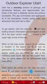
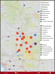
What is outdoor explorer utah - map app? Utah is a geologic wonderland with an incredible amount of canyons, trails, and public land. About two-thirds of Utah is owned by the US Government or the State government and can be enjoyed by everyone! The recreational opportunities range from boating and swimming to rock climbing, bicycling, and hiking.
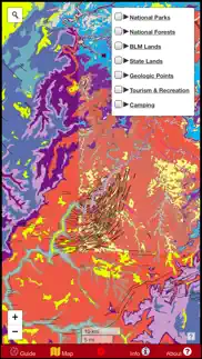
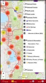
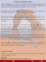
This app is a one-stop resource for all of the public lands in Utah. It includes boundaries, trails, and data points for State Parks, National Parks, BLM Lands, and National Forests, as well as a variety of other point-of-interest information. All points and lines featured in this app are interactive and provide more information in a popup when tapped. The data is supplied as an elegant digital map that can easily be customized to show only the points that interest you.
Some data sets include: Campgrounds, park offices, campsites, waterfalls, vistas, trailheads, hiking trails, tourist attractions, geologic points of interest, hot springs, meteorite recovery sites, boating access, and much more! Over 25,000 points are included, along with thousands of miles of trails and boundaries. Nobody else offers this much data aggregated into one convenient offline app. You do not want to explore Utah without this!
In addition to public data sets aggregated from around the internet, hundreds of independently mapped car campsites along roads in public lands are provided. This data set is proprietary and it is your key to finding the best free camping that Utah has to offer! Why pay $30/night to camp in a National Park when there are millions of acres of federal land where camping is free?
Never get lost again with GPS based navigation and location / coordinate searches are included. Always know exactly where you are so that you can see what attractions are nearby and find what you're after. The navigation feature will work even when your phone is in airplane mode!
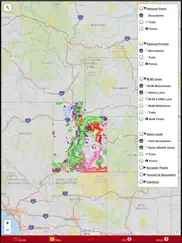
A variety of detailed basemaps are provided: a road map, topo map, geologic map, aerial imagery, and more! Several layers have the capability to be downloaded for offline use so that you never have to worry about having reception or using cellular data in the remote wildernesses of Utah. An offline road map with limited view levels is even bundled in for your convenience.
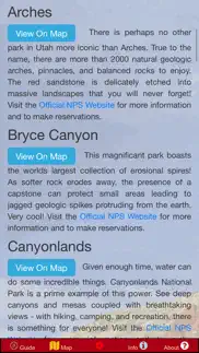
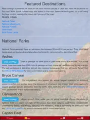
Relevant external links are included for reference and so that you can get the latest official information for a given park or forest without needing to search dozens of websites! Easily locate the major parks and forests and BLM land on the map with static programmed links that automatically pan and zoom the map to the area of interest. It doesn't get any simpler!
NOTE: A great deal of information is included in this app as offline data. The consequence of this is that the app can be a little slow to respond when toggling and viewing certain layers at distant zoom levels. This issue was left unresolved in order to offer the maximum amount of data feasible rather than the fastest performance. If you struggle with this on an older phone, zoom in to an area of interest first. Please have patience when loading these layers and understand this quirk before purchasing the app. If you have any other problems, contact us and we will make it right. Thanks!
GeoPOI LLC is a small, individually owned cartography business founded in Saint Paul, Minnesota. An immense amount of time and effort has gone in to this app in order to make it an invaluable tool for travelers and locals alike. By purchasing this app, you are essentially buying us a drink to fuel our efforts and ensure that quality apps like this will continue to be made in the future for other states. Thank you for your support! If you want to get a feel for the layout and format of the app before buying it, check out some of our other apps at https://geopoi.us
We welcome ideas for future updates; let us know what states you want to explore next!
😍 Do you love Outdoor Explorer Utah - Map app? Please share your friends!

Please wait! Outdoor Explorer Utah - Map app comments loading...
Outdoor Explorer Utah - Map 1.2.0 Tips, Tricks, Cheats and Rules
What do you think of the Outdoor Explorer Utah - Map app? Can you share your complaints, experiences, or thoughts about the application with GeoPOI LLC and other users?
Outdoor Explorer Utah - Map 1.2.0 Apps Screenshots & Images
Outdoor Explorer Utah - Map iphone, ipad, apple watch and apple tv screenshot images, pictures.
| Language | English |
| Price | $1.99 |
| Adult Rating | 12+ years and older |
| Current Version | 1.2.0 |
| Play Store | com.geopoi.xut |
| Compatibility | iOS 9.0 or later |
Outdoor Explorer Utah - Map (Versiyon 1.2.0) Install & Download
The application Outdoor Explorer Utah - Map was published in the category Navigation on 28 July 2018, Saturday and was developed by GeoPOI LLC [Developer ID: 1335041500]. This program file size is 60.87 MB. This app has been rated by 14 users and has a rating of 1 out of 5. Outdoor Explorer Utah - Map - Navigation app posted on 22 May 2022, Sunday current version is 1.2.0 and works well on iOS 9.0 and higher versions. Google Play ID: com.geopoi.xut. Languages supported by the app:
EN Download & Install Now!| App Name | Score | Comments | Price |
| BC Coast Mushroom Forager Reviews | 1 | No comment | $2.99 |
| Pennsylvania Mushroom Forager Reviews | 1 | No comment | $2.99 |
| Border Route Trail Offline Map Reviews | 5 | 1 | $0.99 |
| BLM Public Lands Map Guide USA Reviews | 2.9 | 11 | $2.99 |
| Twin Cities Fallout Shelters Reviews | 3 | 2 | $4.99 |
Added a new terrain basemap layer with elevation!
| App Name | Released |
| Volta Charging | 11 June 2015 |
| Google Maps | 12 December 2012 |
| Premium Parking | 22 October 2013 |
| Footpath Route Planner | 07 May 2013 |
| KakaoMap - Korea No.1 Map | 27 February 2009 |
Find on this site the customer service details of Outdoor Explorer Utah - Map. Besides contact details, the page also offers a brief overview of the digital toy company.
| App Name | Released |
| Sun Seeker - Tracker, Surveyor | 04 October 2009 |
| Spyglass | 04 October 2009 |
| Jacksonville Zoo - ZooMap | 25 October 2021 |
| NavRules | 07 March 2011 |
| Los Angeles Zoo - LA ZooMap | 10 May 2022 |
Discover how specific cryptocurrencies work — and get a bit of each crypto to try out for yourself. Coinbase is the easiest place to buy and sell cryptocurrency. Sign up and get started today.
| App Name | Released |
| Gas | 27 August 2022 |
| Wizz - Make new friends | 24 February 2019 |
| Telegram Messenger | 14 August 2013 |
| Spotify - Music and Podcasts | 14 July 2011 |
| CapCut - Video Editor | 14 April 2020 |
Looking for comprehensive training in Google Analytics 4? We've compiled the top paid and free GA4 courses available in 2024.
| App Name | Released |
| Poppy Playtime Chapter 1 | 08 March 2022 |
| Paprika Recipe Manager 3 | 15 November 2017 |
| Pou | 26 November 2012 |
| Geometry Dash | 13 August 2013 |
| Bloons TD 5 | 15 November 2012 |
Each capsule is packed with pure, high-potency nootropic nutrients. No pointless additives. Just 100% natural brainpower. Third-party tested and validated by the Clean Label Project.
Adsterra is the most preferred ad network for those looking for an alternative to AdSense. Adsterra is the ideal choice for new sites with low daily traffic. In order to advertise on the site in Adsterra, like other ad networks, a certain traffic limit, domain age, etc. is required. There are no strict rules.
The easy, affordable way to create your professional portfolio website, store, blog & client galleries. No coding needed. Try free now.
Outdoor Explorer Utah - Map Comments & Reviews 2024
We transfer money over €4 billion every month. We enable individual and business accounts to save 4 million Euros on bank transfer fees. Want to send free money abroad or transfer money abroad for free? Free international money transfer!
Did you know that you can earn 25 USD from our site just by registering? Get $25 for free by joining Payoneer!