SeaNav App Reviews
SeaNav App Description & Overview
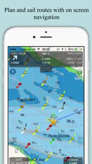
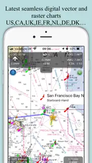
What is seanav app? SeaNav combines high-resolution marine charts, route planning and real-time navigation in one simple boating app for your iPhone, iPad and Apple Watch.
Charts, Autoroute planning, AIS ship tracking, tides and weather in one powerful and affordable navigation app.
Built from official hydrographic data with extensive coverage across North America, Europe and Australia.
Professional marine navigation features including:
Planning
• Create and edit routes with auto-routing for creating waypoints
• Measure distance & bearing
• Import & export GPX routes
• Tides, Streams & Weather
• Works offline
Navigate with Confidence
• Real-time GPS navigation
• Course Up & North Up modes
• ETA, XTE, VMG, SOG & COG
• Sailing HUD display
• Background navigation
• Automatic Waypoint advancing & alerts
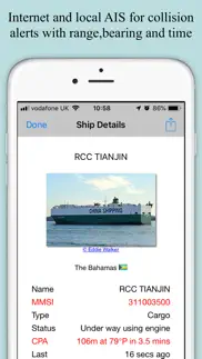
Live AIS & Safety (Optional IAP)
• Real-time AIS ship positions
• Collision alarms
• AIS position sharing
• Internet AIS integration
• Free AIS when used with Boat Beacon
• MOB and Anchor alarm (IAP)
- NMEA Link for Depth, Wind & AutoPilot
- Real time local wind feed and Sailing laylines display (IAP)
Alongside this SeaNav offers advanced onboard capabilities rarely found in a single app:
Apple Watch app
SeaNav for Apple Watch is included at no extra cost, giving you route data, key navigation information and quick access controls directly from your wrist.
Sophisticated AIS Display and Position sharing
The leader in the field with global coverage and clear, information-rich vessel tracking with intelligent filtering and collision prediction tools.
CPA and TCPA alerts help you assess risk early and act confidently.
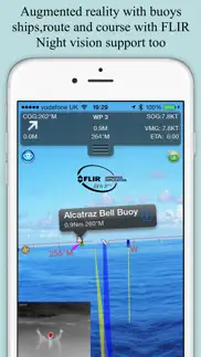
Augmented Reality View
Overlays navigation, AIS and chart data directly onto the real-world camera view for intuitive situational awareness.
Includes night mode support for compatible thermal cameras such as FLIR.
SeaNav Autoroute and Autopilot Integration
- Just choose where you want to go and SeaNav will create the route for you
- Go one step further and let SeaNav pilot the route with compatible autopilot systems from Raymarine, SIMRAD, Lowrance and B&G
SeaNav comes with a built-in tutorial mode with free access to all features including charts, AIS, AR & wind
The free version includes all navigation and trip planning tools. High resolution vector charts are available by In App Purchase (IAP) including updates for 12 months.
Requirements:
GPS only required for real time route navigation. Optional Real time AIS, Tides and Weather information require an active internet connection.
WiFi-only iPad will need an external GPS receiver for navigation.
Please note that continued use of GPS running in the background can dramatically decrease battery life.
Subscriptions
Our in-app purchases are 1 year subscriptions, which automatically renew at the end of the subscription period unless auto-renew is turned off at least 24-hours before the end of the current period. Payment will be charged to your iTunes Account at confirmation of purchase, and will be charged for renewal within 24-hours prior to the end of the current period.
Subscriptions may be managed by the iTunes account holder and auto-renewal may be turned off by going to Account Settings after purchase.
No cancellation of the current subscription is allowed during active subscription period.
NOTICES: This product has been derived in part from material obtained from the UK Hydrographic Office with the permission of the UK Hydrographic Office, Her Majesty’s Stationery Office.” “© British Crown Copyright, [2026]. All rights reserved.
The UK Hydrographic Office (UKHO) and its licensors make no warranties or representations, express or implied, with respect to this product. The UKHO and its licensors have not verified the information within this product or quality assured it.
Terms of Use: http://seanav.net/termsofuse.php
Privacy Policy: http://seanav.net/privacy.php
Support: [email protected]
😍 Do you love SeaNav app? Please share your friends!

Please wait! SeaNav app comments loading...
SeaNav 5.5.5 Tips, Tricks, Cheats and Rules
What do you think of the SeaNav app? Can you share your complaints, experiences, or thoughts about the application with Pocket Mariner Ltd. and other users?


SeaNav 5.5.5 Apps Screenshots & Images
SeaNav iphone, ipad, apple watch and apple tv screenshot images, pictures.
| Language | English |
| Price | Free |
| Adult Rating | 4+ years and older |
| Current Version | 5.5.5 |
| Play Store | com.electricpocket.seanav.zz |
| Compatibility | iOS 15.6 or later |
SeaNav (Versiyon 5.5.5) Install & Download
The application SeaNav was published in the category Navigation on 24 April 2014, Thursday and was developed by Pocket Mariner Ltd. [Developer ID: 719592131]. This program file size is 157.86 MB. This app has been rated by 240 users and has a rating of 4.3 out of 5. SeaNav - Navigation app posted on 18 May 2026, Monday current version is 5.5.5 and works well on iOS 15.6 and higher versions. Google Play ID: com.electricpocket.seanav.zz. Languages supported by the app:
DA EN FR DE IT ES SV Download & Install Now!| App Name | Score | Comments | Price |
| Compass Eye Bearing Compass Reviews | 4.5 | 5 | $4.99 |
| Boat Beacon Reviews | 4.6 | 847 | $14.99 |
| Boat Watch Pro Reviews | 4.5 | 88 | $7.99 |
| Boat Watch Pro Reviews | 1 | No comment | $6.99 |
| SeaNav US Reviews | 4.3 | 100 | $19.99 |
Improvements to Auto-routing
| App Name | Released |
| NAVER Map, Navigation | 01 May 2009 |
| Google Maps | 12 December 2012 |
| Bluebikes | 11 July 2017 |
| DC Metro and Bus | 19 November 2012 |
| Randonautica | 19 February 2020 |
Find on this site the customer service details of SeaNav. Besides contact details, the page also offers a brief overview of the digital toy company.
| App Name | Released |
| FlightReady E6B | 10 October 2015 |
| Speedometer 55 Pro. GPS kit. | 10 June 2012 |
| Cachly - Geocaching | 11 December 2015 |
| GPX-Viewer | 23 May 2014 |
| Moon Seeker | 09 June 2010 |
Discover how specific cryptocurrencies work — and get a bit of each crypto to try out for yourself. Coinbase is the easiest place to buy and sell cryptocurrency. Sign up and get started today.
| App Name | Released |
| 09 October 2009 | |
| CapCut - Video Editor | 14 April 2020 |
| Spotify - Music and Podcasts | 14 July 2011 |
| 28 April 2011 | |
| Messenger | 09 August 2011 |
Install the Giftmio extension for smart shopping. Get notified about cashback opportunities, activate cashback in one click, and save money on purchases.
| App Name | Released |
| PeakFinder | 12 March 2010 |
| Farming Simulator 26 Mobile | 19 May 2026 |
| Monash FODMAP Diet | 17 December 2012 |
| Stardew Valley | 24 October 2018 |
| Bloons TD 6 | 14 June 2018 |
Each capsule is packed with pure, high-potency nootropic nutrients. No pointless additives. Just 100% natural brainpower. Third-party tested and validated by the Clean Label Project.
Adsterra is the most preferred ad network for those looking for an alternative to AdSense. Adsterra is the ideal choice for new sites with low daily traffic. In order to advertise on the site in Adsterra, like other ad networks, a certain traffic limit, domain age, etc. is required. There are no strict rules.
Keep personal info private, avoid scams, and protect yourself online with AI-powered technology.
SeaNav Comments & Reviews 2026
Great help. Excellent
By far, the best sail nav app available. Of all the apps I've tried in this genre, this is the very best one and well worth the $$. The vector maps are amazing in detail, easy to read and super fast even on older iOS devices (aka iPhone 4). Great in--route tracking and tracing. Amazing HUD. Fabulous for nighttime navigation. Active captain integration is terrific as well. My only wishes would we course integration with nmea 2000 devices (autopilot, etc). as well as easy export import of route plans between iOS devices.
Sailing mode crash. Cannot start sailing mode to test all functions supporting apple watch (period)
Not worth it!!. I’d suggest switching to android and making a one time fee of $15 for MX Mariner. Although this app offers some great instruments and charts I don’t believe it’s worth all the money. In the US you’re looking at $20 a year just for the charts and that doesn’t include another $10 for the Raster charts plus another $10 for AIS instrument. It just keeps adding up. If you’re actually using it to Navigate the waterways good luck cause you can’t even zoom in enough to see if you’re inside of the channels. The person who designed this isn’t thinking about the Mariners they’re in it for the money! Just saying, don’t waste your time and money on this one better off downloading a free one for IOS.
Misleading marketing do not buy. They do not make it clear that chart purchases are required. To make it even more misleading I can’t use the charts Boat Beacon which I already purchased from them. There was a link in Boat Beacon to SeaNav saying I could navigate with SeaNav and show AIS overlays on the charts. Well now they want me to repurchase the charts I already bought from them
Excellent program. Had this installed for a while and I’m now beginning to use it. Integrates well with my Wind Instrument. The building of routes and importing waypoints stumped me but after reading the Help document. After working with the app and companion app Boat Beacon, I am really impressed. Excellent response from help desk/support and they want user feedback to guide their future app updates. I am changing my rating from 4 to 5 stars.
Intuitive and accurate. I have had SeaNav for a year now and have learned to trust it. It is just as accurate as any high dollar system and is easy to use.
I’m pay 29.99$ can’t do anything never manage a new route then I have to buy more and more 😩😩. Feel unhappy with this 😩🙁❇️
Awesome tool. This has to be one of the best tools to have in your hands.
Penny-lane2282. Excellent
Question. Can you see water depth on Apple Watch ?
Wouldn’t sail without it!. Love knowing what went buy in the middle of the night when anchored. And what’s coming by before I can see it! Catalina 380 Hull 123
Excellent nav tool. Best app for marine navigation bar none! In-app purchases are also well priced and actually increase functionality and usefulness. Must buy for boaters, especially big water.
Fantastic. Works great.
Great for this newbie. I am a novice boat renter. This app really helped me stay on course in unfamiliar waters.
Great tracking app. I use this for near shore tracking and marking favorite fishing spots
I have paid $30 bucks. Nothing works what a thief you are Shame on you
Did you know that you can earn 25 USD from our site just by registering? Get $25 for free by joining Payoneer!
Waste of time. Rubbish
Best sailing app. What a great app, especially if you have a pebble watch....if you don't go and buy one - we bought two! The ability to pickup data from the onboard b&g and get that relayed to my watch is invaluable. Depth graph, TWA, TTW, count down. It's all there ! Defiantly worth the investment.
Confused and buggy. There are so many buttons and on iPhone X some of them are hidden under the clock and battery indicators at the top and you can’t tap them. Crashes when I press the boat button
Imagine you at your best. All the time. Picture yourself at your sharpest and most productive. Your most alert and focused. Your most lucid, creative and confident. At work. At play. In every area of your life. Add Mind Lab Pro® v4.0 to your daily routine and uncap your true potential. Buy Now!
Useful app. Works great on my iPad. The app has lots of features. Route planning, storage of waypoints, information and reviews of anchorages. You can click anywhere and instantly see the depth at that point. I don't have a cellular connection on my iPad. I bought a portable wifi connected GPS antenna from Bad Elf. The antenna fits in the palm of my hand, and is rechargeable. I then have proper GPS coverage anywhere. I could see where I was 700 miles north of Hawaii. In local waters I connect to my iPhone then I can get live AIS information. I only make this connection when I need it to look at nearby boats. I don't want to eat up wireless minutes.
Sea nav great for cruising. I watch the SeaNav app when we are cruise to watch our ship and the current and winds while we travel
Super app. Really like this app and the info on my Apple watch. But above all outstanding support!
First use during 4 day Lake Erie cruise. Hi, We just got back from 4 days sailing Port Dover -> Port Maitland -> Port Colborne -> Port Maitland -> Port Dover. We had installed SeaNav and Navionics on a pair of iPads connected to our NMEA 2000 system via a Yacht Devices YDWG-02 server port. SeaNav easily won the evaluation and we did not try to use the Navionics after the first day. An outstanding success! David Bramwell Sailing vessel Eriewinds, Port Dover
Total disappointment. Charts are not detailed. Maps have very low resolution. Speed reading was way off. Waste of time and money
NOAA CHARTS ARE FREE TO THE PUBLIC. Any app that makes you pay for them is ripping you off…
Great app with accurate Canadien data. I like this supporting app to plan my selling navigation and play back. To the dev team. Keep going on dev.
Adsterra is the most preferred ad network for those looking for an alternative to AdSense. Adsterra is the ideal choice for new sites with low daily traffic. In order to advertise on the site in Adsterra, like other ad networks, a certain traffic limit, domain age, etc. is required. There are no strict rules. Sign up!