NZ Topo50 South Island App Reviews
NZ Topo50 South Island App Description & Overview
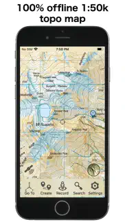
What is nz topo50 south island app? This app provides complete offline topographic map coverage of the South Island of New Zealand from the LINZ Topo50 1:50k scale map series. The maps are all contained in the installation so there is no additional need for downloads, no need for phone or wifi signal, no slow server issues, no account signups, no missing tiles, and no additional map fees. Just install for seamless off-line zooming and panning across the whole island down to 1:50k scale. The app also includes 1:50k resolution satellite images for the island, and elevation data. Additional aerial imagery can be downloaded.
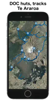
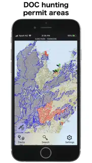
Other integrated data includes DOC hunting permit boundaries, DOC huts, campgrounds, and tracks, Fish and Game access points, Te Araroa trails, Public Conservation Land boundaries, selected public road parcels, and many more.
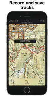
The app has a full suite of navigation functions including GPS location, compass orientation, distance to map locations, track recording and graphing, route creation and following, hillshade and slope angle overlays, import/export of gpx and kml files, search functions for named places and user data. Add and edit your own locations and routes and plot elevation profiles. Set proximity alarms. Live location sharing. Use your camera view to identify surrounding peaks and match with local topography. Uses an intuitive simple interface with one-touch access to all functions.
LINZ TOPO250 series maps are used at lower zoom levels for easier navigation.
Perfect for outback use out of cell phone range. GPS and maps function fully without phone coverage. No need to cache files in advance either as they are all fully installed with the app. Popular with trampers, hikers, runners, bikers, search and rescue (SAR), hunters, boaters, flying, paragliding, as well as survey applications.
Note that continuous use of GPS will run down the battery faster than when not using the GPS. The NZTopo50 app gives you full control over when GPS is used. The map can be used without GPS, intermittently with GPS for spot checking of location, continuously for logging while the app is open, or for continuous background logging when the phone is off.
Check our website for links to user guides and useful tips and tricks.
The in-app purchases are for an optional contribution to ongoing app development, or for selected additional third party data sets. They don't affect the functionality of the app or the availability of updates.
Feel free to get in touch with any suggestions.
😍 Do you love NZ Topo50 South Island app? Please share your friends!



Please wait! NZ Topo50 South Island app comments loading...
NZ Topo50 South Island 6.03.03 Tips, Tricks, Cheats and Rules
What do you think of the NZ Topo50 South Island app? Can you share your complaints, experiences, or thoughts about the application with Right Place Resources and other users?


NZ Topo50 South Island 6.03.03 Apps Screenshots & Images
NZ Topo50 South Island iphone, ipad, apple watch and apple tv screenshot images, pictures.
| Language | English |
| Price | $3.99 |
| Adult Rating | 4+ years and older |
| Current Version | 6.03.03 |
| Play Store | sqrl.net.NZTopo50.SI |
| Compatibility | iOS 16.6 or later |
NZ Topo50 South Island (Versiyon 6.03.03) Install & Download
The application NZ Topo50 South Island was published in the category Navigation on 27 February 2013, Wednesday and was developed by Right Place Resources [Developer ID: 522317291]. This program file size is 2.75 GB. This app has been rated by 9 users and has a rating of 4.1 out of 5. NZ Topo50 South Island - Navigation app posted on 09 May 2026, Saturday current version is 6.03.03 and works well on iOS 16.6 and higher versions. Google Play ID: sqrl.net.NZTopo50.SI. Languages supported by the app:
EN Download & Install Now!| App Name | Score | Comments | Price |
| NZ Charts Reviews | 1 | No comment | $2.99 |
| NZ Topo50 North Island Reviews | 5 | 2 | $3.99 |
| GBTopoMap Reviews | 5 | 2 | $1.99 |
Minor layout changes
| App Name | Released |
| Neshan Map | 04 May 2023 |
| Bonjour RATP | 14 May 2012 |
| EVgo - Fast EV Charging | 17 October 2017 |
| Speedometer Simple | 18 November 2014 |
| Divvy Bikes | 16 May 2018 |
Find on this site the customer service details of NZ Topo50 South Island. Besides contact details, the page also offers a brief overview of the digital toy company.
| App Name | Released |
| NavRules | 07 March 2011 |
| LocaToWeb | 04 August 2012 |
| Cachly - Geocaching | 11 December 2015 |
| Bronx Zoo - ZooMap | 16 May 2021 |
| FlightReady E6B | 10 October 2015 |
Discover how specific cryptocurrencies work — and get a bit of each crypto to try out for yourself. Coinbase is the easiest place to buy and sell cryptocurrency. Sign up and get started today.
| App Name | Released |
| Spotify - Music and Podcasts | 14 July 2011 |
| WhatsApp Messenger | 03 May 2009 |
| Messenger | 09 August 2011 |
| SHEIN - Online Fashion | 19 May 2014 |
| Cash App | 16 October 2013 |
Install the Giftmio extension for smart shopping. Get notified about cashback opportunities, activate cashback in one click, and save money on purchases.
| App Name | Released |
| Pou | 26 November 2012 |
| Subnautica | 08 July 2025 |
| MilGPS | 01 December 2010 |
| Stardew Valley | 24 October 2018 |
| Farming Simulator 26 Mobile | 19 May 2026 |
Each capsule is packed with pure, high-potency nootropic nutrients. No pointless additives. Just 100% natural brainpower. Third-party tested and validated by the Clean Label Project.
Adsterra is the most preferred ad network for those looking for an alternative to AdSense. Adsterra is the ideal choice for new sites with low daily traffic. In order to advertise on the site in Adsterra, like other ad networks, a certain traffic limit, domain age, etc. is required. There are no strict rules.
Keep personal info private, avoid scams, and protect yourself online with AI-powered technology.
NZ Topo50 South Island Comments & Reviews 2026
Useless for navigation. These maps only show little floating bits of trails (tracks), not the complete ones. It’s impossible to tell where they go or how they connect to each other
Excellent!. I used it for navigating a number of different tracks and it worked flawlessly. Also, the search feature is handy for exploring areas.
Did you know that you can earn 25 USD from our site just by registering? Get $25 for free by joining Payoneer!
BEST APP FOR THE NZ BUSH. Excellent navigation tool set. Comprehensive yet simple to use. Nothing else comes close.
Brilliant!!!. Was the best $5 I ever spent! Was such a valuable tool...didn't have to pull out a map book even once! Pinpoint accuracy plus worked of GPS signal I remote regions! Awesome!
Great. Best of the 4 of have tried. Better than toast.
Imagine you at your best. All the time. Picture yourself at your sharpest and most productive. Your most alert and focused. Your most lucid, creative and confident. At work. At play. In every area of your life. Add Mind Lab Pro® v4.0 to your daily routine and uncap your true potential. Buy Now!
Get this app if your doing NZ backcountry. I got this app for a fly fishing trip and WOW. It’s saved my but on these trails to access fishing as it’s easy to fall off the trail in the unmarked remote huts and everything. But also the trails that’s DOC maintained. It’s a saving grace and helps find new water and Huts to stay at! GET IT
Adsterra is the most preferred ad network for those looking for an alternative to AdSense. Adsterra is the ideal choice for new sites with low daily traffic. In order to advertise on the site in Adsterra, like other ad networks, a certain traffic limit, domain age, etc. is required. There are no strict rules. Sign up!