Wildfire Info App Reviews
Wildfire Info App Description & Overview
What is wildfire info app? Disclaimer: This unofficial app does not represent any government agency and is not affiliated with any government agency. The sources of the data are the publicly accessible sources listed below.
Browse current wildfire and prescribed burn activity throughout all of the world.
Active Wildfire Perimeter data from NIFC WFIGS. Tagged by state, search by name, and filter by acres burned. WFIGS stands for the Wildland Fire Interagency Geospatial Services (WFIGS) Group. NIFC stands for the National Interagency Fire Center. NIFC WFIGS Source URLs: https://www.nifc.gov/ with data hosted at https://data-nifc.opendata.arcgis.com/datasets/nifc::wfigs-current-interagency-fire-perimeters/about
NASA MODIS and VIIRS satellite instruments data: Thermal hotspot maps by region show wildfire activity in the past 48 hours. See hotspot info including fire radiance power, brightness temperature, and confidence. NASA MODIS/VIIRS Source URL: https://firms.modaps.eosdis.nasa.gov/active_fire/ . MODIS stands for Moderate Resolution Imaging Spectroradiometer. VIIRS stands for Visible Infrared Imaging Radiometer Suite.
InciWeb & CAL FIRE active fire maps: hot-link to the corresponding official incident webpage. Inciweb Source URL: https://inciweb.wildfire.gov/ , CAL FIRE Source URL: https://www.fire.ca.gov/incidents
CHP (California Highway Patrol): Incidents in the past 3 hours related to fires are filtered out separately, all traffic incidents are included viewable by last 1 or 3 hours.CHP Source URL: https://cad.chp.ca.gov/Traffic.aspx
Lookup current hyper-local weather conditions, including temperature, wind and gust conditions, and local forecasts anywhere in the USA, Canada, or Australia using map quick lookup or, for USA, search: Detailed NWS Forecast, Hourly Forecast, Grid Data Forecast, and Summary Forecast. Data is from the NWS, NOAA, Government of Canada, and Government of Australia. NWS/NOAA Source URL: https://forecast.weather.gov/, Government of Canada Weather Source URL: https://weather.gc.ca/, Government of Australia Weather Source URL: http://www.bom.gov.au/
Wildfire Situation Reports section with mirrored PDFs from NIFC. NIFC Source URL: https://www.nifc.gov
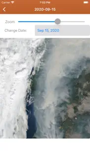
NESDIS GOES 16/17 Satellite Animations show wildfire smoke plumes, drought conditions, etc. from the satellite's perspective. NESDIS GOES Source URL: https://www.star.nesdis.noaa.gov. NESDIS stands for National Environmental Satellite, Data, and Information Service. GOES stands for
Geostationary Operational Environmental Satellite.
A Recent Wildfire News section: find news from 1,700+ cited sources quickly on a map or in a table view tagged by state alphabetically. Set up your own custom state feed with the state toggles. Quickly lookup news source homepages near specific fires.
Map Measurement Tool added to the Map Tools Side Menu. Measure distance and area.
Premium users: View 250m resolution true color images from NASA GIBS (Global Imagery Browse Service). Images are available back to Jan. 1 2007. Worldwide coverage.
Premium Users: Lookup a driving route to any fire or hotspot with Google or Apple Maps directions Universal Links. Save your preferred Directions Provider in the App Settings.
There is a section for wildfire-related US government Twitter accounts viewable by map by approximate location or sorted into national and state sources in a table view. Twitter Source URLs: https://twitter.com
User-Submitted Fire Map feature: map-based wildfire-related chatter. Photos are allowed. Posts and replies are anonymous; no account needed.
Information is posted as soon as it becomes available from WFIGS, NIFC, NASA, InciWeb, CAL FIRE, CHP, NESDIS, NOAA, NWS, Government of Canada, and Government of Australia.
This app is not affiliated with any government agency.
Terms of Use: https://davidgrossapps.com/terms/tos-wildfire-info.html
Privacy Policy: https://davidgrossapps.com/privacy-policy.html
😍 Do you love Wildfire Info app? Please share your friends!

Please wait! Wildfire Info app comments loading...
Wildfire Info 4.8.2 Tips, Tricks, Cheats and Rules
What do you think of the Wildfire Info app? Can you share your complaints, experiences, or thoughts about the application with David Gross and other users?


Wildfire Info 4.8.2 Apps Screenshots & Images
Wildfire Info iphone, ipad, apple watch and apple tv screenshot images, pictures.
| Language | English |
| Price | Free |
| Adult Rating | 12+ years and older |
| Current Version | 4.8.2 |
| Play Store | usa.wildfires |
| Compatibility | iOS 15.6 or later |
Wildfire Info (Versiyon 4.8.2) Install & Download
The application Wildfire Info was published in the category Weather on 14 July 2016, Thursday and was developed by David Gross [Developer ID: 922822485]. This program file size is 4.24 MB. This app has been rated by 31 users and has a rating of 3.4 out of 5. Wildfire Info - Weather app posted on 24 January 2025, Friday current version is 4.8.2 and works well on iOS 15.6 and higher versions. Google Play ID: usa.wildfires. Languages supported by the app:
EN Download & Install Now!| App Name | Score | Comments | Price |
| Doom Scroll Global Reviews | 1 | No comment | Free |
| Find Lot Size Reviews | 2.8 | 6 | Free |
| Map Measurement Tool Reviews | 2.5 | 6 | Free |
| Earthquake Monitor Reviews | 4.8 | 17 | Free |
- Updated to handle the in-app purchase subscription through Apple StoreKit2.
| App Name | Released |
| Beam Tanning - Get Tan Fast | 13 July 2024 |
| Tides Near Me | 12 December 2012 |
| NOAA Live Weather Radar | 16 June 2023 |
| RainDrop - Virtual Rain Gauge | 17 July 2023 |
| Zoom Earth - Live Weather Map | 27 June 2023 |
Find on this site the customer service details of Wildfire Info. Besides contact details, the page also offers a brief overview of the digital toy company.
| App Name | Released |
| My Lightning Tracker Pro | 16 November 2016 |
| Solar Weather - Space Forecast | 30 July 2024 |
| Fishing Times Pro | 18 February 2011 |
| My Aurora Forecast Pro | 26 January 2016 |
| NOAA Radar US | 28 January 2011 |
Discover how specific cryptocurrencies work — and get a bit of each crypto to try out for yourself. Coinbase is the easiest place to buy and sell cryptocurrency. Sign up and get started today.
| App Name | Released |
| Google Maps | 12 December 2012 |
| Gmail - Email by Google | 02 November 2011 |
| TikTok | 02 April 2014 |
| Target | 24 November 2008 |
| Amazon Shopping | 03 December 2008 |
Install the Giftmio extension for smart shopping. Get notified about cashback opportunities, activate cashback in one click, and save money on purchases.
| App Name | Released |
| Slime Rancher | 26 May 2026 |
| Earn to Die 2 | 20 November 2014 |
| Slay the Spire | 13 June 2020 |
| Pou | 26 November 2012 |
| Procreate Pocket | 17 December 2014 |
Each capsule is packed with pure, high-potency nootropic nutrients. No pointless additives. Just 100% natural brainpower. Third-party tested and validated by the Clean Label Project.
Adsterra is the most preferred ad network for those looking for an alternative to AdSense. Adsterra is the ideal choice for new sites with low daily traffic. In order to advertise on the site in Adsterra, like other ad networks, a certain traffic limit, domain age, etc. is required. There are no strict rules.
Keep personal info private, avoid scams, and protect yourself online with AI-powered technology.
Wildfire Info Comments & Reviews 2026
Fires not listed. I live near Nacimiento Lake and after 3 days no mention of this fire. I was looking for an app that would show a map. Quick link to CalFire only good thing. I deleted it.
Barely launches on ios12!!!. Just updated on ios12 and now the app doesn’t even refresh. I’m trying to track fires in my area!!! Update - developer says there was a server issue. Still a great app!
Blank maps. There is a huge fire (Thomas Fire) but most maps are blank or have sparse push pins so this app is useless
Unstable. Crashes frequently. Restarts readily but searching, enlarging image, and hitting the info button bring on failure. I've removed it from my phone.
So far so good. Haven't had a chance to use it much yet but it has several sites with up to date information since it is pulling directly from the sources. Not a great interface but it does pull these sources together on one page.
Great Developer & Important App. This is a crucial app if you love in wildfire country. The developer (David) responded rapidly to my feedback. I’m grateful for this invaluable app and hope it continues to be so well supported and evolved.
Great little app. Really enjoying this app so I can keep tabs on southern California wildfires. Does everything you'd want it to do. Thanks!
Very Very General. Names fires, gives you size and that's about it. Looking for an app with details like the website inciweb, coordinates, fuel type, movement, projected containment, etc.
Out of Date. The information on this app is usually out of date. It shows fires that have been put out months ago.
Not exactly up to the minute info. While Gatlinburg is burning, no info at all😔
Old app needs updated. Interface is basic and old school. Needs a redesign to stay modern. Since other much more modern and frequently updated apps with the same functionality always exist, it’s better to avoid this one - it’s not supported and should probably be retired.
The app unfortunately does not hold record. This app is horrible it is about whenever I try to make a fire go into a place it never updates the wildfires that makes the app bad take it off who needs an app with it I think it reminds me of Wikipedia not encyclopedia but if you can’t delete it just add more wildfires to the app this is reticules I can’t handle it anymore
Wildfire info. Still getting run time errors it never lasted this long I guess it’s time to move on and delete it will be using watch duty for fire info now. This has not been updated for over 3 years not good.
Crashes!. Sounds like a great idea, but it crashes on my iPad 10.5
Not updated anymore. App doesn’t seem to be managed anymore, fires are rarely shown or updated. Used to be a great resource and now is useless.
Love it!. Living in a drought area of California where wildfires have happened, I check this site at least twice daily. Thanks for making me feel more secure.
Crashed every time. It looks like a good app, but it just crashed every time I tried to open it.
Great app!! A must have!!. This is an awesome app for quick access to California Fire status. It streamlines access to fire maps and twitter feeds. Thank you!!
Useless. This app is useless. Wildfires have been raging for 2 days in Napa and Sonoma counties in California with extensive evacuation orders. I’ve been trying to get information but there’s not a peep re. things like CAL Fire incident reports or updates via this app. The best I can do is stale information from the San Francisco newspaper.
Info incomplete. While this looks like a good app, it’s very inconsistent. Many fire perimeter maps are not available. That should be the most important item to show.
Not ALL State In This App NO WA STATE FORESTS. Next to a Washington State Forest. And every summer we worry about forest fires from tourists flipping their cigarettes out on the road in the forest or campfires not put out properly. Or tourist randomly shooting their guns in the forest sparking off a wildfire. But there's nothing here for Washington state. So it does me no good. I'll be deleting this app and look for a WA State app.
Useless. The map will not display. Shows pins and thats all, nothing more. Using IOS 12.4.1.
Wildfire Info not current. The Wildfire app is days behind current events and not effective for emergency public information. I have stopped using it in favor of local emergency services reports.
One Stop Shopping. Lots of links to any Wildfire info you may need in one location. Nice job.
Inciweb at hands reach!. Inciweb is my go to website for all active wildfire events. I do not live in an area prone to wildfires but I do pay close attention to them as I do travel quite a bit. Along with Inciweb this app provides outlooks for the country. Awesome app!
This is what professionals in California have nearby. First, to all the reviewers who don’t know, the ‘Cal’ in Cal Fire stands for California (formerly CDF or California Department of Forestry). This is your first stop for information on wildfires in California so that is where the priority information emphasis is The Cal Fire active fire map is your number one first stop to see the morning and evening report stats and assess each fire in the state. Having the Twitter feed included is golden. Those two features alone are worth having this in you pocket if you use them for work (as I do) could be threatened by an active fire or just want to know what’s going on. (Note - I write very few reviews and am not a Cal Fire employee, but my work puts me at many of the state's biggest wildfires)
Information not current. Perhaps lack of information on the ground limits the ability of any such app to provide current information on fire perimeter, but it would be helpful (particularly for those with family members in or near an impacted area) to have some idea of the present size, growth of a fire, and how much of a threat a fire poses to any certain area. The fire perimeter information hasn’t been updated in nearly 10 hours. A fire can cover a lot of ground in that time.
Works great. 🔥
great app for what it does. who needs the hyperbolic news when you can just get actual fire data direct from reliable sources. love this app - especially when my mom texts from montana with whatever recent sensationalist nonsense the TV has had to say about fires here in california. 5 stars.
A great tool. Thank you so much for such a great app - I had some trouble initially with the fire map not showing anything except the topographical map. The developer contacted me. I deleted and then downloaded the app again. It is now working perfectly.
Will not launch on 13.5.1. The app crashes immediately upon launch. I’ve tried deleting and reinstalling several times to no avail
NO WAY TO SIGN UP FOR ALERTS.. California fires and NO ALERTS?
Impressive array of easy to access data and feeds. Minor suggestions- allow users to bookmark favorite twitter feed for their area. And perhaps explanation of how to interpret the power ratings of MODIS VIIRS readings. Overall- 5 stars.
Doesn’t work well. There is a 90 square mile fire in Woodward County, Oklahoma and the air in Norman 140 miles away is filled with smoke, but this app doesn’t know about it! Deleted.
Did you know that you can earn 25 USD from our site just by registering? Get $25 for free by joining Payoneer!
Imagine you at your best. All the time. Picture yourself at your sharpest and most productive. Your most alert and focused. Your most lucid, creative and confident. At work. At play. In every area of your life. Add Mind Lab Pro® v4.0 to your daily routine and uncap your true potential. Buy Now!
Adsterra is the most preferred ad network for those looking for an alternative to AdSense. Adsterra is the ideal choice for new sites with low daily traffic. In order to advertise on the site in Adsterra, like other ad networks, a certain traffic limit, domain age, etc. is required. There are no strict rules. Sign up!