Hoge Veluwe National Park GPS and outdoor map
Hoge Veluwe National Park GPS and outdoor map Uygulama İncelemesi
Hoge Veluwe National Park GPS and outdoor map uygulaması nedir, nasıl kullanılır? ■ “Download any FlytoMap application for Free! By purchasing FlytoMap All-in-One App.”
■ !! Watch "FlyToMap GPS" app video on www.appreview.com and www.youtube.com !!
[Version: 2.5 - Topo]
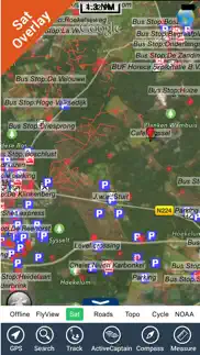
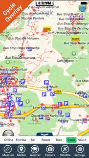
► New Design - Exclusively for the iPhone 3.0: FlyToMap multi-dimensional charts OVERLAYED with Satellite photos and map features.
► The unique application on App Store with this cutting edge technology.
► New iPhone 3GS Magnetic Compass integration.
--------------------------------------------------------------------------------------------------------------------------
- PARK MAPS:
Park maps are extremely advanced embedded electronic charts with all information collected from the National/State Park and Forest Services and many other local sources. The maps contain all trails (Hiking, Biking, Equestrian trails etc.,) and Points of interests (POI) like Campgrounds, Visitor Centers, Lookout points, Eating places, Ranger Stations, Picnic areas, Boat/Canoe ramps, Parking areas etc. and much more:
“all Trails, Lakes and Rivers within the Parks”
“Park boundary”
“Elevation Contours with 10 meters step” (only "Topo" version)
“Mountain Peaks”
“All Roads and Railways”
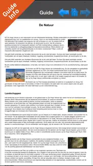
...and full Travel Guide with photos, maps, history, not to miss places.....
--------------------------------------------------------------------------------------------------------------------------
How to use:
“Zoom and Pan fast just by a finger touch”
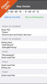
“Use Latitudes and Longitudes to go to your favorite places”
"Record your GPS Track"
“Detailed touristic guide at your finger's disposal”
“Navigate and see your GPS position on the map”
“Geo-Tagged photo management”
“Insert the target/destination ‘Waypoint’ and see in real time your speed, distance and direction to destination”
“Insert Unlimited Markers near favorite places on the map”
“Search your Favorite points or any location by name”
“Set On/Off Elevation Contours if you feel data is cluttering”
- WATER MAPS (Marine):
The new ‘iPhone Marine Navigator’: it contains embedded Electronic Nautical Charts (ENC) from NOAA and Corps of Engineers compressed to store the largest coverage. You can transform your iPhone in a chart plotter with best NOAA-USACE, ENC S57 cartography; which includes Coastline, Anchoring areas, Fishing areas, Restriction areas, Obstructions, Rocks, Buoys, Beacons, Lights, Depth contours (with values displayed in real time on map), Spot Soundings and more. Every effort is made to be as accurate as possible when presenting information for every sea area.
- LAKE MAPS:
High quality lake maps with detailed information and important features compressed to assure the larger coverage. Lake maps contain the most important lakes with detailed Depth Contours, Boat Ramps, Fishing spots etc. Maps also include Trails, Roads and Railways information.
- TRAVEL MAPS:
These Maps cover most interesting touristic areas combining Sea and Land information to allow you a complete travel experience. These are the best Maps to travel on fascinating voyages; map focus on the best Beach spots along the Coastline, Major ports, Sailing, Fishing, Picnic areas, Parks, Hiking, Biking, Clubs, Restaurants, Famous Hotels, Museums, Shopping areas, and much more.
A Travel Guide with photos, maps, history, not to miss places..... is included.
- HUNT MAPS:
These maps are designed specifically for hunting activities.
They contain the best hunting maps of the area with all the information for a safety and unforgettable hunting experience.
These maps are including all Parks, Forests, Trails, Huts, WMA (Wildlife Management Areas), Refuges, Point of Interests, etc. and a complete topographic map (Elevation contours, lakes, rivers, streams, roads, etc.).
A complete Hunting Guide with information about Season, Limits, Licensing, restrictions, etc.......is included.
"Continued use of GPS running in the background can dramatically decrease battery life."
👋 Hoge Veluwe National Park GPS and outdoor map aplikasyonunu beğendiyseniz arkadaşlarınızla paylaşır mısınız?
| Uygulama Adı | Hoge Veluwe National Park GPS and outdoor map |
| Kategori | Seyahat |
| Geliştirici | Flytomap |
| Yayın Tarihi | 1 Şubat 2016 Pazartesi |
| Güncelleme | 4 Ağustos 2017 Cuma |
| Dosya Boyutu | 19.85 MB |
Hoge Veluwe National Park GPS and outdoor map Hakkındaki Yorumlar
Her ay dört milyar € üzerinde para transferi gerçekleştiriyoruz. Bireysel ve işletme hesaplarınının banka transfer ücretlerinden 4 milyon Euro tasarruf etmelerini sağlıyoruz. Yurtdışına ücretsiz para göndermek veya yurtdışında ücretsiz para transfer etmek ister misiniz? Ücretsiz uluslararası para transferi!
Sadece kaydolarak sitemizden 25 Dolar kazanabileceğinizi biliyor muydunuz? Payoneer'a katılarak ücretsiz 25$ kazanın!

Lütfen bekleyin! Hoge Veluwe National Park GPS and outdoor map uygulama yorumları yükleniyor...
Hoge Veluwe National Park GPS and outdoor map Müşteri Hizmetleri
Hoge Veluwe National Park GPS and outdoor map aplikasyonu hakkında ne düşünüyorsunuz? Uygulama hakkındaki şikayet, deneyim veya düşüncelerinizi Flytomap şirketi ve insanlarla paylaşır mısınız?
Hoge Veluwe National Park GPS and outdoor map Uygulaması Ekran Görüntüleri & Resimleri
Hoge Veluwe National Park GPS and outdoor map uygulaması iphone, ipad, apple watch ve apple tv aplikasyon görüntüleri.
| Dil | Türkçe |
| Fiyat | 79.99 TL |
| Yaş Sınırı | 4+ yaş ve üstü |
| Son Versiyon | 5.5 |
| Play Store | com.flytomap.PMDeHgeVeluwePark |
| Uyumluluk | IOS 9.0 ve üstü |
Hoge Veluwe National Park GPS and outdoor map (Versiyon 5.5) Aplikasyonu İndir & Yükle
Hoge Veluwe National Park GPS and outdoor map ios uygulaması Flytomap [Geliştirici ID: 297575434] tarafından geliştirilip, 1 Şubat 2016 Pazartesi günü Seyahat kategorisinde yayınlanmıştır. Aplikasyonun dosya boyutu 19.85 MB'tır. Bu uygulama 15 kullanıcı tarafından oylanmış ve 5 üzerinden 1 puan almıştır. Hoge Veluwe National Park GPS and outdoor map programının 4 Ağustos 2017 Cuma günü yayınlanan son sürümü 5.5 versiyonudur. Minumum IOS 9.0 ve üzeri cihazlarda sorunsuz olarak çalışmaktadır. Google Play Store ID numarası: com.flytomap.PMDeHgeVeluwePark. Uygulamanın desteklediği diller şunlardır:
EN FR IT ES Uygulamayı İndir & Yükle!
| Uygulama Adı | Puan | Yorumlar | Fiyat |
| Mediterranean Sea GPS Charts | 1 | Yorum yapılmamış | 499.99 |
| Great Lakes HD Nautical Charts | 1 | Yorum yapılmamış | 599.99 |
| Maldives GPS Map Navigator | 1 | Yorum yapılmamış | 399.99 |
| UK Ireland Nautical Charts HD | 1 | Yorum yapılmamış | 599.99 |
| Mediterranean Sea HD GPS Chart | 1 | Yorum yapılmamış | 499.99 |
This app has been updated by Apple to display the Apple Watch app icon. Track improvement Marine Weather algorithm update
| Uygulama Adı | Geliştirici |
| Airbnb | Airbnb, Inc. |
| BinBin Scooters | Bin Ulaşım ve Akıllı Şehir Teknolojileri A.Ş. |
| Wizz Air - Book Flights | Wizz Air Hungary Ltd. |
| Jolly Tur | Club Jolly Turizm ve Ticaret Anonim Şirketi |
| SunExpress | Güneş Ekspres Havacılık A.Ş. (SunExpress) |
VPN programları, dünyanın her yerinden sınırsız ve güvenli internet erişimi sağlayarak internete erişmenin en güvenli yolunu sunar. Uzman ekibimizin objektif incelemeleri ve derinlemesine analizleri ile ihtiyacınıza uygun 2024 yılının en iyi VPN programını seçin!
| Uygulama Adı | Geliştirici |
| PeakFinder | PeakFinder GmbH |
| Offline Translator Turkish Pro | SkyCode Ltd. |
| Fog of World | Ollix |
| Offline Translator Pro 8 lang | SkyCode Ltd. |
| TripView | TripView Pty Ltd |
Farklı kripto para birimlerinin nasıl işlediğini keşfedin ve bizzat denemek üzere her kriptodan küçük bir tutar kazanın. Coinbase, kripto satın almak ve satmak için en kolay yerdir. Kaydolun, hemen başlayın.
| Uygulama Adı | Developer |
| Instagram, Inc. | |
| Gmail - Email by Google | |
| Threads, an Instagram app | Instagram, Inc. |
| Meta Platforms, Inc. | |
| Snapchat | Snap, Inc. |
Jasper, size ve ekibinize 10 kat daha hızlı şaşırtıcı, orijinal içerik oluşturmak için yaratıcı engelleri aşmanıza yardımcı olan yapay zeka içerik üreticisidir.
| Uygulama Adı | Geliştirici |
| CameLoCorpions | Loan Thao |
| Legendary Car Transporter | Tap2Play, LLC (Ticker: TAPM) |
| Capeemo | WIMMOV |
| Buku Catatan Keluarga | Khubaib Azain Jillani |
| BatThousandMilesSearchAnswers | Nguyen Bao Duy |
Mind Lab Pro ® odaklanma, stres altında çoklu görev yapma, yaratıcı problem çözme ve daha fazlası için nootropiklerle iş performansını ve üretkenliğini arttıran bilimsel bir ilaçtır. Beyninizi %100 performansa çıkarın!
Adsterra, AdSenseye alternatif arayanların en çok tercih ettiği reklam ağıdır. Adsterra, günlük site trafiği düşük olan yeni siteler için en ideal bir seçimdir. Adsterra’da siteye reklam vermek için diğer reklam ağları gibi belli bir trafik sınırı, domain yaşı vb. katı kurallar bulunmuyor.