Cairngorms Maps Offline
Cairngorms Maps Offline App Description et Analyse
Qu'est-ce que l'application Cairngorms Maps Offline? From the producers of GB Maps (featured in Ordnance Survey's OS OpenData innovative application showcase)
Beautifully detailed maps supplied by Ordnance Survey.
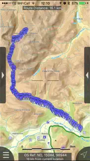
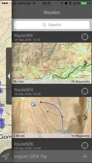
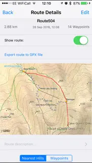
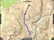
Cairngorms Maps provides a useful offline (no mobile signal required) mapping reference and navigation aid whilst travelling throughout the Cairngorms by footpath, road, rail, canal, loch and river. Intuitive route and waypoint management features are implemented enabling creation, modification, deletion, import and export of routes. A powerful offline search facility can locate places, roads, post codes and hills within the region. Worldwide online Apple Maps (Standard, Satellite and Hybrid) with map features that users are used to are available on both offline and online maps as well as providing 3D buildings on Apple maps (where available).
Maps
6 different levels of offline 2014/2015 Ordnance Survey map detail from national overview. (No data connection required)
Progressively more detailed maps are automatically loaded as the map view is zoomed. The OS recommended viewing scales for the more detailed maps are approximately as follows:
1:1000,000 (The whole of GB is covered at this map scale)
1:250,000
1:50,000
1:25,000
The map region of the more detailed maps covers a rectangular region around the national park boundary (ref. http://jomosolutions.com/Maps)
- Contours with height information and annotated height points.
- Extensive footpaths from ©OpenStreetMap contributors
- National Park boundary demarkation
App
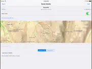
- Route/Waypoint management
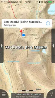
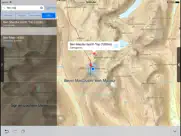
- Offline search functionality with searchable locations (places, roads, post codes and hills). (For the place search a location's latitude and longitude is accurate to 0.1 of a minute of the centre point of the 1x1 km National Grid square in which the name falls)
- Detailed hill information, including height, OS Grid Ref, latitude and longitude, region, parent, classification, drop and hill specific links to Streetmap, Geograph and Hill Bagging web sites
- Display of current GPS position as OS Grid Reference or WGS84 latitude and longitude
- "Share My Location" allowing users to share an image of their current location and location references. Buttons are provided to share location information by Facebook, Twitter, iMessage/SMS and e-mail
- Online access to worldwide Apple Standard, Satellite and Hybrid maps
- Apple 3D Buildings are displayed on Apple Standard maps
- Apple maps contain Points of Interest
- User location can be tracked with or without heading on all online and offline maps (GPS capable devices only)
- Display of scale bar in either metric or imperial units
- Display of current speed
- Zoom, pan, rotation of all maps
- Pitch of Apple Standard and Ordnance Survey maps
- Selection of current location annotation for display of speed and location data
- User setting for speed display in Miles per Hour (mph) or Kilometres per Hour (kph)
- Selection of search result pin annotations to display location information
- Collective deletion of search result annotation pins
- A user guide is provided within the app information
Further application details.
The post code, place name and road name data was published by Ordnance Survey in 2014.
Extracts from "The Database of British and Irish Hills" v14 published 22/04/2014 (ref. http://www.hills-database.co.uk/index.html )
No warranty
The data is supplied by Apple, Ordnance Survey, contributors to OpenStreetMap and Database of British and Irish Hills.
The Information is licensed 'as is' and the Information Provider and/or Licensor excludes all representations, warranties, obligations and liabilities in relation to the Information to the maximum extent permitted by law.
The Information Provider and/or Licensor are not liable for any errors or omissions in the Information and shall not be liable for any loss, injury or damage of any kind caused by its use.
This app is not a substitute for a paper map and compass.
👋 Si vous aimez l'application Cairngorms Maps Offline, pouvez-vous la partager avec vos amis?
| Nom de l'application | Cairngorms Maps Offline |
| Catégorie | Navigation |
| Développeur | JOMO Solutions Ltd |
| Date de Sortie | samedi 9 mai 2015 |
| Mis à jour | lundi 3 décembre 2018 |
| Taille du Fichier | 430.67 MB |
Cairngorms Maps Offline Commentaires et Critiques (2024)
Nous transférons plus de 4 milliards d'euros chaque mois. Nous permettons aux comptes individuels et professionnels d'économiser 4 millions d'euros sur les frais de virement bancaire. Vous voulez envoyer de l'argent gratuitement à l'étranger ou transférer de l'argent à l'étranger gratuitement? Transfert d'argent international gratuit!
Saviez-vous que vous pouvez gagner 25 USD sur notre site simplement en vous inscrivant? Obtenez 25$ gratuitement en rejoignant Payoneer!

S'il vous plaît, attendez! Chargement des commentaires du jeu cairngorms maps offline...
Cairngorms Maps Offline Client de Service
Que pensez-vous de l'application Cairngorms Maps Offline? Pouvez-vous partager vos plaintes, expériences ou réflexions sur l'application avec JOMO Solutions Ltd et les autres?
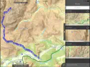
Cairngorms Maps Offline Apps Captures D'écran et Images
Cairngorms Maps Offline iphone, ipad, apple watch ve apple tv images d'application.
| Langue | French |
| Prix | 1.99 EUR |
| Limite d'âge | 4+ ans et plus |
| Dernière version | 2.1.1 |
| Play Store | com.jomosolutions.Cairngorms-Maps |
| Compatibilité | iOS 8.0 ou version ultérieure |
Installation et Téléchargement de l'application Cairngorms Maps Offline (Version 2.1.1)
L'application Cairngorms Maps Offline ios a été développée par JOMO Solutions Ltd [ID développeur: 953796555] et est sortie dans la catégorie Navigation le samedi 9 mai 2015. La taille du fichier de l'application est de 430.67 MB. Cette application a été évaluée par 15 utilisateurs et a une note de 1 sur 5. La dernière version de Cairngorms Maps Offline publiée le mercredi lundi 3 décembre 2018 est la 2.1.1. Le logiciel IOS 8.0 et supérieur fonctionne correctement. Google Play ID: com.jomosolutions.Cairngorms-Maps. Langues prises en charge par l'application:
EN Téléchargez et installez maintenant!| Nom de l'application | Puan | Commentaires | Prix |
| Brecon Beacons Maps Offline | 1 | Sans commentaires | 1.99 |
| Yorkshire Dales Maps Offline | 1 | Sans commentaires | 1.99 |
| Northumberland Maps Offline | 1 | Sans commentaires | 1.99 |
| The Broads Maps Offline | 1 | Sans commentaires | 1.99 |
| Fylde Maps Offline | 5 | 1 | Gratuit |
Fixed intermittent failures within the search functionality. If you like the app please leave an app review.
| Nom de l'application | Développeur |
| Klaxit - Covoiturage quotidien | KLAXIT |
| Wikiloc Navigation Outdoor GPS | Wikiloc Outdoor SL |
| Karos - covoiturage quotidien | Karos |
| Bolt Driver | BOLT TECHNOLOGY OU |
| Bonjour RATP | RATP Smart Systems |
Vérifiez-vous les résultats de votre travail de référencement? Ou regardez-vous simplement le classement de vos mots clés dans Google? Si vous ne pouvez pas lire correctement les données de votre travail de référencement, vous perdez beaucoup!
| Nom de l'application | Développeur |
| TripRoad | Burotica |
| BringGo Western Europe | Engis Technologies.Inc |
| Direction Compass With Maps | Chaviro Software |
| MapOut | Valnova |
| POIViewer | FrenchKiss Development |
Découvrez comment fonctionnent des crypto-monnaies spécifiques - et obtenez un peu de chaque crypto à essayer par vous-même. Coinbase est l'endroit le plus simple pour acheter et vendre des crypto-monnaies. Inscrivez-vous et commencez dès aujourd'hui.
| Nom de l'application | Développeur |
| X | X Corp. |
| Doctolib | Doctolib |
| Revolut - La banque en ligne | Revolut Ltd |
| Duolingo | Duolingo |
| Meta Platforms, Inc. |
Jasper est la plateforme d'IA générative pour les entreprises qui aide votre équipe à créer du contenu adapté à votre marque 10 fois plus rapidement, où que vous travailliez en ligne.
| Nom de l'application | Développeur |
| Amazing Nail Art Salon | Pravinkumar Parmar |
| Canyon Creek School Cougars | Canyon Creek School Cougars |
| APS Sidekick | Grant Olsen |
| Cookie or Biscuit | Anton Semakov |
| Arum Shop | Arum 3D Solutions Ltd |
Chaque capsule est remplie de nutriments nootropes purs et puissants. Aucun additif inutile. Juste une matière grise 100% naturelle. Testé et validé par une tierce partie par le Clean Label Project.
Adsterra est le réseau publicitaire préféré de ceux qui recherchent une alternative à AdSense. Adsterra est le choix idéal pour les nouveaux sites à faible trafic quotidien. Afin de faire de la publicité sur le site dans Adsterra, comme d'autres réseaux publicitaires, une certaine limite de trafic, l'âge du domaine, etc. est requis. Il n'y a pas de règles strictes.