TrailLink: Bike, Run, Walk App Reviews
TrailLink: Bike, Run, Walk App Description & Overview
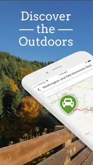
What is traillink: bike, run, walk app? TrailLink is the ultimate trail-finder app to help you stay active and get outdoors. Enjoy full-length trail descriptions, reviews, photos, and detailed trail maps not found anywhere else!
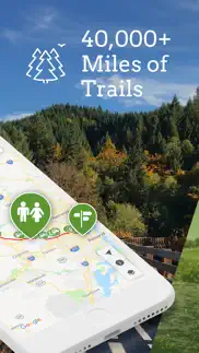
Discover amazing trails near you that are perfect for cycling, jogging, walking, workouts and more. Explore over 40,000 miles of multi-use trails in the US, all carefully curated for quality.
Want to get started biking, walking trails or jogging? Subscribe to TrailLink Unlimited for detailed offline trail maps, plus tens of thousands of trail amenity waypoints.
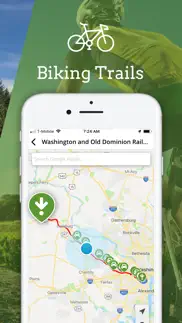
Find walking trails with exercise stations, biking trails with great views and much more. Find fitness anywhere you walk or ride with the best trails near you.
Empower your next on-the-trail adventures, whether you’re hiking, biking, jogging or walking.
TrailLink is powered by Rails-to-Trails Conservancy (RTC) expert trails database which offers unique trail-finder functionality. Plus, TrailLink Unlimited lets you search Google Places for easy access to trail-side businesses.
Rails-to-Trails Conservancy's GIS mapping initiatives have produced more than 40,000 miles of highly accurate trail maps. Download trail maps and access them any time, then share your trail photos and trips with friends.
Take TrailLink with you today and let Rails-to-Trails Conservancy be your expert guide out on the trail. Try it out today and register to get your first map for free!
Download TrailLink today for:
OUTDOOR EXERCISE
• Discover the joys out the outdoors with scenic walking and biking trails near you.
• Get outside and get in shape whether you’re a beginner or an outdoor enthusiast.
FIND TRAILS
• Search for trails near you or by location
• Search for trails on the map
• Search for Google Places on the map
• Download trail maps for offline use
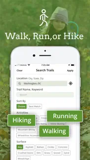
• Find the best trails for jogging, walking or biking
TRAILS FOR ALL TRIPS
• Find trails for jogging
• Biking routes
• Walking trails
• Hiking trails
• And more!
TRAIL REVIEWS
• Read RTC's expert trail descriptions
• Read and write trail reviews
• Save your trail favorites
SHARE YOUR ROUTES
• Upload trail photos
• Share trails with friends
TRAIL DIRECTIONS & INFORMATION
• See your location on the trail
• Generate driving directions
• Amenity waypoints like exercise stations, trailheads, tunnels and drinking fountains
• Find restrooms, parking & much more
RAILS-TO-TRAILS CONNECTION
• Sync your account with TrailLink's website
• Support the mission of Rails-to-Trails Conservancy!
Download the TrailLink app today and let RTC guide your way!
The TrailLink app offers the Unlimited subscription in the app directly through your iTunes Account for only $29.99 for 12 months of unlimited offline map downloads. The TrailLink Unlimited subscription will automatically renew for $29.99 after 12 months unless you cancel your subscription at least 24hrs before the end of the current subscription period. You can cancel at any time and manage your subscription, including turning off auto-renewal, in your Account Settings.
To view TrailLink Terms of Use policy, please visit: https://www.traillink.com/terms-of-use/
To view Rails-to-Trails Conservancy's Privacy Policy, please visit: https://www.railstotrails.org/privacy/
😍 Do you love TrailLink: Bike, Run, Walk app? Please share your friends!

Please wait! TrailLink: Bike, Run, Walk app comments loading...
TrailLink: Bike, Run, Walk 2.6.1 Tips, Tricks, Cheats and Rules
What do you think of the TrailLink: Bike, Run, Walk app? Can you share your complaints, experiences, or thoughts about the application with Rails-to-Trails Conservancy and other users?
TrailLink: Bike, Run, Walk 2.6.1 Apps Screenshots & Images
TrailLink: Bike, Run, Walk iphone, ipad, apple watch and apple tv screenshot images, pictures.
| Language | English |
| Price | Free |
| Adult Rating | 4+ years and older |
| Current Version | 2.6.1 |
| Play Store | org.railstotrails.traillink |
| Compatibility | iOS 14.0 or later |
TrailLink: Bike, Run, Walk (Versiyon 2.6.1) Install & Download
The application TrailLink: Bike, Run, Walk was published in the category Health & Fitness on 11 November 2013, Monday and was developed by Rails-to-Trails Conservancy [Developer ID: 636875511]. This program file size is 64.75 MB. This app has been rated by 6,446 users and has a rating of 4.5 out of 5. TrailLink: Bike, Run, Walk - Health & Fitness app posted on 14 July 2023, Friday current version is 2.6.1 and works well on iOS 14.0 and higher versions. Google Play ID: org.railstotrails.traillink. Languages supported by the app:
EN Download & Install Now!| App Name | Score | Comments | Price |
Bug fixes and improvements
| App Name | Released |
| Calm | 22 February 2013 |
| InPulse - Heart Rate Monitor | 07 December 2019 |
| OnSkin - AI Product Scanner | 14 December 2022 |
| Workout Planner Muscle Booster | 21 December 2018 |
| Aetna Health | 31 December 2017 |
Find on this site the customer service details of TrailLink: Bike, Run, Walk. Besides contact details, the page also offers a brief overview of the digital toy company.
| App Name | Released |
| Fast Tract Diet | 16 December 2015 |
| Starting Strength Official | 08 September 2015 |
| IMuscle 2 - iPhone Edition | 08 June 2011 |
| HealthFit | 25 September 2017 |
| My Pollen Forecast Pro | 12 June 2017 |
Discover how specific cryptocurrencies work — and get a bit of each crypto to try out for yourself. Coinbase is the easiest place to buy and sell cryptocurrency. Sign up and get started today.
| App Name | Released |
| Telegram Messenger | 14 August 2013 |
| SHEIN - Online Fashion | 19 May 2014 |
| 28 April 2011 | |
| Amazon Shopping | 03 December 2008 |
| PayPal - Send, Shop, Manage | 03 February 2019 |
Looking for comprehensive training in Google Analytics 4? We've compiled the top paid and free GA4 courses available in 2024.
| App Name | Released |
| Terraria | 28 August 2013 |
| AnkiMobile Flashcards | 26 May 2010 |
| True Skate | 18 October 2012 |
| Plague Inc. | 25 May 2012 |
| Monash FODMAP Diet | 17 December 2012 |
Each capsule is packed with pure, high-potency nootropic nutrients. No pointless additives. Just 100% natural brainpower. Third-party tested and validated by the Clean Label Project.
Adsterra is the most preferred ad network for those looking for an alternative to AdSense. Adsterra is the ideal choice for new sites with low daily traffic. In order to advertise on the site in Adsterra, like other ad networks, a certain traffic limit, domain age, etc. is required. There are no strict rules.
The easy, affordable way to create your professional portfolio website, store, blog & client galleries. No coding needed. Try free now.
TrailLink: Bike, Run, Walk Comments & Reviews 2024
We transfer money over €4 billion every month. We enable individual and business accounts to save 4 million Euros on bank transfer fees. Want to send free money abroad or transfer money abroad for free? Free international money transfer!
Recent Update Still Buggy. Thanks to the Developer for contacting me. I will get in touch with you later today. I’ll take screenshots of the issues I’m coming across. Catch up with you soon. _______________ Thanks for the recent update. Initially after the recent update I had trouble logging in, couldn’t access my Favorites, I couldn’t add any new Favorites, and I couldn’t access my Downloads. As well, I would keep getting a message saying there is an error with the Format. While I am able to do the above now, there still are some bugs. For example, My Favorites show up a (0) but when I click into Favorites they are there. I still keep getting that Format error whenever I try to access anything Trail or Map related.
Newest Update resolves previous issues. I love TrailLink. It is my go to resource for finding new trails in new locations. The app allows me to find suitable trails for my road bike, and then helps me easily navigate to them. The maps, trail info, and reviews are extremely valuable to me. It will still take me a little more time to get used to the new UI, but the developer seems to have fixed the problems I previously had. Thanks, TrailLink, for reaching out to me and working to make the app awesome again. ******** previous review: Most of my favorite functionality is gone in the new update. I hate that I can no longer “redo search in this area” to search for trails in the area I have showing on the map. I am a truck driver and pretty much search for new trails every day, depending on where I happen to be that day. The search location screen is disastrous. If I try to tap one of the autofill suggestions, entirely different cities and states are filled in. I also hate that I can no longer just scroll around the map and see all the trails in the country. I know, with new updates it takes a while to get the wrinkles ironed out. I have faith the developers will fix these problems. Hopefully soon, as this is one of my most often used apps! *******end of previous review
Tunnel Hill Trail is awesome!. My 14 yo granddaughter accompanied me as we traversed the 5.75 miles from the Vienna trailhead at Vienna City Park just west of I-24 up to the Trestle Bridge and returned - making for an 11.5 mile ride. It is a very slight and manageable grade up less than 90 feet in elevation with the grade never getting over 2%. Neither of us are super athletic and we did the “up run” in about 39 minutes, trimming the time back to about 32 minutes. The trail looks a well shaded and the gravel surface is well-maintained. Hoping to take in another section soon.
Trail link app. I ordered the Florida map and then loaded the app while I’m waiting for the paper map ( I love paper maps) and found the app to be super cool easy to use and has a ton of biker useful features. To unlock all the features you have to spend a little cash but even if you don’t do that you have access to all the maps. Becoming a member and getting access to the full features allows you to save the trails, comment add pics etc. Plus have off line access to the maps. I will most likely subscribe for this as well.
Excellent bike trail outstanding View. I have to say who ever worked on this trail they did a great job very nice trail I am so happy that it’s getting open ,For those negative people technically the trail it’s not open to the public for our safety manners we should be happy that Let us use it while they’re working this trail means a lot it’s connecting far away all the way down to the Bronx I am from Mahopac NY and I just ride the trail back-and-forth for 30 miles I can’t wait until it gets done if there is more stars I will give them more thank you so much guys for working so hard to finish our bike trail , this trail has a excellent ride nice and smooth
First time user > forever user. My boyfriend & I took our dog on this hike. It was so much fun. Make sure that you follow the signs because there are so many different trails intertwining throughout the hike. Using the map is ideal in a few places but mostly, just follow the signs. It was an amazing day hike, however; I’d recommend going earlier during the day because we got to the end of the trial & it was sunset. The most beautiful sunset view I’ve seen in a while. We walked back through the neighborhood because it was dark, that was also beautiful & very well lit. We will definitely be back.
Excellent resource. However needs to have tracking capabilities like All Trails!. Rails to Trails is a terrific conservancy and this companion map is a wonderful resource for planning trips to some of the most beautiful rides available. Been using the app for many years and it continues to get better. I use it in conjunction with the Rails to Trails Facebook page. I’d like to add that they do need to update the the many completions and additions as they have not made it in here. I’d also add that there need to be a ‘print’ function for a paper map!
Great Trail!. Our cycling group tried this trail for the first time this weekend. We started at the Chiefland trailhead and headed to Fanning Springs! Note: there’s no restrooms at the Fanning Springs trailhead. We then headed towards Old Town and rode to the bridge over the Suwannee River. Take the time to look out over the river and take in the beauty! Then we turned around and rode towards Trenton. Rode to the old train depot and there’s restrooms there! Yay! Then we headed back to Chiefland and rode a total of 41 miles. The trail is nice, maintained with a few bumps here and there. It was not heavily trafficked on a Friday afternoon and was a beautiful trail. We would ride this trail again. Pack water! Side note: there’s a hole in the wall bbq place right by the Fanning Springs trailheads that has great food! Get out and enjoy!
Chipman Trail’s Washboard Woes. The Chipman Trail from Moscow to Pullman is a horribly jarring, bumpy ride for 7+ miles. Every 20-40 yards along this 7 mile trail are 3-4 inch wide, 1-3 inch deep, gaps in the asphalt pours running the entire width of the path. A beautiful morning ride with nice Palouse scenery became progressively and incessantly tortuous. It is like riding on a washboard. If you're in Moscow, as an alternative, | highly recommend the Eastward bound trail to Troy, a 12 mile, much more beautiful, and smooth as silk Latah Trail. Latah Trail This is a fantastic trail. Don’t miss this one!! 12 miles each way, Moscow to Troy. Generally flat with several mild grades. The asphalt tarmac is smooth and in great condition. Eastbound, beautiful Palouse scenery gives way to lightly, then heavily-forested grades ending in Troy. Bring adequate water, snacks, etc. There are frequent benches along the route. One or two pit toilets along route. Flush toilet at Troy Park, with a gas station and snack spot as well.
Disappointed. Full of annoyances and problems. Big icons cover and obscure map, very poor map navigation, oversimplified trail maps, very few (and confusing) display options, repeated annoying pop up, always resets to Washington DC, rife with outdated info, iPad version displays only portrait view, Trails Near Me shows trails hundreds of miles away in other states. Local governments do such a poor job of their own trail web sites that it leaves the door open for poor apps like this. While the app is not a complete waste of time, I’ll be on the lookout for a better app for sure! NEXT DAY RESPONSE FROM THE DEVELOPER states their opinion that my review is “overly critical”! Wow, not only a very poor site, but a very, very testy developer! I certainly don’t expect improvement after such a smug response! (Adjusted rating down to one star.)
Lamoille Trail like heaven. Just came back from two days of doing about 65% of the Lamoille Trail. First day we basically went from Morrisville where we were staying to. Hardwick had a nice little breakfast there and rode back in the most hellacious thunder and lightning storm that we’ve ever drove through, there is a saying that whatever doesn’t kill you makes you stronger well we’re basically super humans now because there was lightning flashes and thunder when we were on steel bridges, but yet the trail held up marvelously considering the huge huge amounts of rain that were just pouring down at one point I couldn’t even see it was so much so this is basically a very positive review for that. The next day I have a good fortune of having a cousin that lives in Saint Albans, so we went from Morrisville to Sheldon Junction and then took the trails into Saint Albans that was about 45 miles and it was a beautiful day after the drenching rain this trail was in great shape. Bravo.
It’s OK. Nice to have things in one place but the paid subscription lacks any real useful features that I can’t get for free somewhere else. Yes you can download the info for offline use with a subscription but most rail trail info can be found at the specific trail website where you can print it out or turn the web page into a .pdf for offline use. Even after buying the subscription you can’t print out any of the info and the app hasn’t been updated to give a better experience on a tablet, it’s still a small map, it’s a phone experience on a tablet. I won’t be re-subscribing
Better than we expected. Gorgeous with interesting historical component with commentary about Lewis and Clark journey. Close to shore and pounding waves yet accessible to a commercial area if you want to buy lunch. Some sharp blind curves with tall salt grasses that hide oncoming bikes and peds. Ideal for moderately paced, low stress rides. We parked at Beard’s Hollow trailhead and accidentally started over the wooden bridge and up the dirt path. Steep and slippery. Ideal for MTB but not our gravel bikes. When we came back to the parking lot we chose the asphalt trail which featured a relatively flat asphalt surface through the tall grasses and pines. After riding to the end of the trail (Lewis & Clark carved tree) we rode back through Beards Hollow parking lot and cycled up to the North Head lighthouse. Great spin through a dense forest. Well designed and maintained trail. If we lived here, we’d do this trail ALOT.
G&S Trolley Trail. I used my electric wheelchair and the trail was wide and easy to navigate. I found the terrain rolling with one large hill I climbed easily with no slowing or large battery drain. The trail isn’t very scenic but will get you outdoors, you should either have someone meet you on either end and I don't recommend trying the Bluff Point Trail that connects to the Neptune Drive end unless you are very comfortable navigating rocky ground and steep ground. I enjoyed myself and will do this trail again.
Challenging trail. I love OCA! But it’s not a walk in the park and if you are looking for a cardio training path you might be disappointed with the stops and starts. The terrain can be rough with rocks and roots and erosion damage especially after heavy rain. Thicker tires are necessary. Certain spots also have a lot of pedestrian traffic and they are often oblivious to their surroundings with earbuds drowning out your approach warnings. I’ve had people wander right in front of my path even as I’m shouting “on your left!!” It is beautiful, though! Lots of deer and other critters watch silently as you pedal past.
Nothing is free.. Went to download this app to view some Connecticut trails. I view them once for like 10 seconds, then you need to UPGRADE and pay more to download or access even the most basic trail map. These maps are online in PDF format for free. Stay clear of this app—unless you want to feel ripped off! Response: It’s nice to say your trail maps are free. They aren’t. Try downloading your own app. I tried to access them from the app and everything is PAY MORE. If you want to charge for everything little thing, that’s fine. But don’t say you’re offering a functional free app because that is not the case. I literally couldn’t not access the public trail map without paying!
Awesome ride. I recently moved here from Long Island. I take my bike to Poughkeepsie and ride across the bridge. It’s on a slight upward angle as you’re driving across but on the return it’s very fast and you’re coasting a lot of the ride. There are water fountains and small areas where you can sit and have picnics if you like. It’s a very easy ride, and the views are spectacular. Whenever I have family or guest visiting I usually take them there to see the beautiful Hudson Valley from above. I highly recommend it if you’re not from the Hudson in Valley area. 🚴♀️
Trail terrain. It would be a great improvement to trails if areas with gravel were replaced with hard pack or short stretches of asphalt. The gravel makes it impossible for people who need to used a mobility scooter and those folks NEED to be able to access the trails too. I ride my bike and have gone from trailhead on 230 in Elizabethtown on Conewago to trail head by Southhills Park in Lebanon, the Lebanon Rail Trail. Nice that the trails connect up. Lebanon County trails are better maintained and have many benches so walkers, bikers, etc. can stop for a rest. Lancaster County needs to step it up with benches and trail maintenance for the Conewago. The entire stretch is scenic. I love going on the two trails but wish it was made more accessible for those who have special needs and use scooters. One more thing, I think electric bikes do not below on the trail. Just my opinion.
Always beautiful.. I rode this trail once again, 8/6/21, and it did not disappoint. Since I rode it last, from Rupert to Granville, it has been resurfaced with crushed rock. It is consistent, and allows for a wider pathway than the former surface, two narrow ruts between a center gas’s strip. I wouldn’t recommend a skinny tire bike, but my hybrid with wider tires was a comfortable ride. The diverse scenery- swamp with birds and cattails, pastures with cut hay, old factories slowly settling into oblivion, lots of running water next to the trail - always captivates me. I find this southern portion of the D&H is a very special, quiet, remote place. Always beautiful, whatever the season.
User error?. I’m confused. This app is a great way to research trails, but does not have a navigation feature once you’re at the trail you want to ride? I’m an unlimited user, and downloaded the map. I’m using the TrailLink app on an iPhone. For example, I’m trying to decide what portion of the Oak Leaf Trail we want to ride today. So far this week we’ve done the Capital City, the Elroy-Sparta, and the Ozaukee, all of which have a matching map in the AllTrails app that I used for navigation. The Oak Leaf only has small portions in All Trails. Please advise.
Sunday at La Porte trail. Sunday I parked at the city park, 600 Little Cedar Bayou Drive. The start of the trail is to the left of the tennis courts by the blue trash can. I just traveled West-East along Fairmont Parkway to San Jacinto community college (13 miles around trip). The entire trail is paved, however some of it was under water. Perhaps from the rain the night before. There’s a huge overpass had to downshift to first gear. This trail is in a rural area and industrial businesses are along the path. I did see a few benches and trash cans along the way. I saw one cyclist and a golf cart very desolate. If a little tender loving care TLC was invested this could be a whole lot better trail attracting more cyclists. Not recommended for greater than 8 mph.
Worth the drive from Morehead. I love love love this trail. It’s paved all the way and surrounded by natural beauty. I saw ducks, ducklings in a pond, goats, beautiful homes, fall foliage, pastoral looking views, heard beavers gnawing in the creek that runs adjacent to the trail, all kinds of nature. This was a much needed break from all the Covid and election stuff. There were several bicyclers, walkers, and joggers (mostly bicyclers). My son and I parked at Archer park and rode all the way to the neat school bus bridge and back. I could not think of a better way to spend a beautiful November Saturday! I’m definitely doing this again!
National Grid destruction. This was once a magnificent trail with an astonishing variety of plant and shrub species that in no way comprised the integrity of the power lines running above it and through a wetland that supported a myriad of mammals, reptiles, insects and birds. However this past winter of 2020 National Grid cut it down to the ground and all that’s left are dead sticks and stumps. They completely destroyed a thriving ecosystem. It was a crime and done against the will of the Georgetown Conservation Commission and residents who complained. Herbicides luckily have not been used and at least the wood ducks returned this spring, but it is a depressing sight. I can only hope that in time nature will endure and re-establish what was once there and that utility companies will be prevented from ever doing anything like this again, something I am working to help ensure.
Very Nice Ride. Great asphalt route through wooded area with a portion along the Red River. There are two steep areas where they ask you to walk your bike, and a sign halfway that says no bikes beyond this point; which no one paid attention to. The quality of the trail was great all the way until it dead ends at the river. It was roughly 5 miles to the river. Mid-way there are restrooms if you start at the Clarksville trail head. Mostly saw walkers with their strollers and dogs along the route.
Greenbrier River Trail. AWESOME trail! After a 4 hour drive, we began our bike adventure in Cass, WV. We biked 10 miles to Clover Lick. We had two vehicles, so it made it easy to do the whole trail caravaning one at the end point each day. We stayed at Watoga State Park as our home base. ABSOLUTELY BEAUTIFUL! Day 2, we biked Clover Lick to Seebert. Day 3: Seebert to Rennick. Day 4 Rennick to North Caldwell. There were some down trees to navigate along the way, but we reported them to the ranger and it appeared they were on top of the cleanup. Advise getting directions from the rangers as some of the roads and drop off points are narrow and sketchy. Our plan seemed to work out fine and we were thankful we took their advice. Because of all the rain and according to the locals, the water levels were up and the river extra beautiful!
So helpful! motivating and inspiring!. Great for finding local trails - but also for planning biking options while traveling! Plus fun for dreaming/planning for a future ride of the Great American Rail Trail. Inspiring to see all the wonderful and beautiful trails to tackle in my future! The one upgrade I’d love would be of the trail icons for the trails to be included in the Great American Rail Trail has a different colored icon so it would be easier to pick them out when scrolling around the country.
Good info. Needs refinement.. App contains good info on trails. Once the UI is learned, navigation is fair. It's a pretty good resource for finding rail trails. I use it to find (gravel) rail trails for bike rides. However, there are a few areas that could use improvement. First, the area map only shows trail beginnings. If you're looking at a place that's part of a trail that's hundreds of miles long, unless you know where the trail starts, you wouldn't even know there's a trail. Additionally, some trails (like the entire east to west) are broken down into sections of sub trails, so you not only need to know where the trail starts, you need to know the start of that section according to the app's data. There needs to be a way to show the trail on the big map, not just within the trail details. Trail info lacks elevation info. Nothing on elevation change and no elevation profile graph. Makes planning difficult. Need to have elevation graph with info, and, better yet, also a way to correspond point on graph with map and vise versa. Finally, no native iPad app seems opportunity lost. Map exploration could use the extra screen real estate. Good info. Good start. Good potential. Hope to see more improvement.
Well Kept Surface and Scenic Views. I parked at the Plymouth Sorrento parking area and road to Sanford and back. This was a 20 mile round trip from 7am to 9 am. This trail is a well defined well kept road surface. It was filled with wildlife sightings which made it a pleasant ride for myself because I enjoy seeing wildlife in its nature habitat. I recommend this trail for both the serious rider as well as the novice rider looking to enjoy a ride with beautiful views of natural Florida habitat. Deer, Wild Turkey, Bears, Wild Hogs, Alligators, and numerous bird sightings are common from a safe vantage point. Enjoy your ride as I did!!
THE BEST WAY TO RECYCLE TRAIN TRACKS. I am not always sure getting rid of trains for transportation of goods/products was a good idea. Especially when one considers all the man power it took to lay them. Let alone all the tractor trailers now on our highways due to their closings. There is no better way to reuse them in my opinion then to convert them for bike riding and walking. It connects us humans to nature and each other. In some cases it’s bringing small towns, that were left behind during the rails decline, back to life. All while preserving our national heritage of the folks that built these great tracks. Where’s your bike taking you next?
New website is making me crazy. Your new website is very difficult. I have multiple trails I’ve purchased and downloaded. When I go into your site to look at which trail we wish to ride I cannot navigant back to the home page without signing out then logging back in. Very frustrating and not user friendly. You can do better. The old format was much easier to use
Lake Barkley Multi-use Trail (LBL). Today, all in all, we drove our bikes a total of 13 miles around the Eggner Ferry Bridge at KY Lake (LBL). We attempted to ride over & thru the Central Hardwoods Trail (LBL) but not long onto this trail we encountered a fallen tree across it. As this trail is 11 miles long and meanders through the woods, we figured most likely we’d encounter even more fallen trees, so we opted to turn back. As it was the Memorial Day weekend, the traffic was rather busy along Hwy 68-80 so we headed back toward Ken Lake Resort. Tomorrow we’ll drive over and “launch” our bikes closer to the 68-80 bridge near Lake Barkley. This trail appears to be much longer than today’s trail with a well protected bike-walking path from vehicular traffic. We had a blast and, Lord willing, looking forward to completing more trails down the road!
Love the app but have one suggestion. I love this app. We just got into biking this year and have enjoyed trying out new routes. I prefer biking on trails more than roads and have downloaded a dozen maps so far. They are very useful since most trials don’t have adequate signage and therefore we can use gps with the app. My only complaint is this. We prefer to ride a minimum of 20 miles at a time. If I see a trail that is only 3 miles long I will skip it. Not worth the drive. But I’ve realized that a lot of these continue where another trail ended. It’s really hard to see this on the app. Would be nice to have a filter on the app that would show all the trails in an area. All in all I love this app. Can’t wait to go out and explore more trails.
Cross Island & Terrapin Beach Park was amazing. Found this gem on Trail Link! We parked at Terrapin Beach Park and took the cross island trail. It was so serene, flat, and smooth! I’ve only been biking for a few days so I would highly recommend this for other beginners as well. We were not able to do the full trail (we wanted to reserve some energy for the beach) so we turned around near the end. We rode 9.38miles round trip then we headed to the beach by bike. It was so easy to social distance on the trail and on the beach. Everything was beautiful and calming.
Live the app. Recently upgraded to Full, so glad I did! Was able to print out guides that interested us at home. Then, on the road, we can see where we are on the trail at all times. This weekend we did the Cape Cod Rail Trail our and back and got stuck in the rain for 2 hours about 10 miles in. There was an awesome nearby coffee shop where we holed up and the map still kept track of us. We resumed the ride. The app had our back! Cool “completed” button. Keeps track of all the trails we’ve done.
Island Rail Trail. Beautiful easy ride. We started at Local Motion where we rented bikes. They were nice and helpful but busy. Give yourself time and reserve ahead of time. That helps. We rode to the end of the trail and went into South Hero for lunch at Wally’s. Very good. Give yourself time at ferry crossing as well. It can be busy and they only take about 18 people per ride. Also make sure to go back to the start at mile 1. There’s a cool earth clock in the park. This truly is a gorgeous and mostly flat ride.
You need this app. My wife I use the app to plan trios across country on rail trails. It provides great access to information like finding places to stay. A useful feature would be the ability to view more than one map at a time. Right now we’re at the midpoint of the Chief Ladiga Trail. It would be nice to both Chief Ladiga Trail and Silver Comet at the same time since both meet at the state line. We had the same issue earlier this month in Dayton, Ohio and Xenia, Ohio. Same in upper Michigan
5 Miles on Homestead “Express” Trail. I only rode this 5 miles from the TH by the bar “The Rail,” but it was very pleasant. The trail starts being paved but turns to limestone approximately 1 mile. There were turkeys and babies within that one mile, which is partially shaded. The trail outside of Beatrice is well shaded for the first couple of miles. This makes for a cool breeze while hammering the pedals. You’ll cross four wooden bridges in those 5 miles, tracing Indian Creek part of the ways. I even spotted a fawn drinking from the creek. The only down side was the brush sticks out too far when crossing the roads. The city need to trim it. I highly recommend surfing Homestead “Express” Trail for a reconnection with nature and a blast into Gage County history!!
Mileage. As depicted - just a comment regarding the mileage stated in the description/when you click on the map of the trail. This is 22 miles one way, from Shore Drive to General Booth Blvd. And I can’t agree more with the comment about being careful at the intersection with VB Blvd. I’ve written the city to find out why there is no crosswalk whatsoever. There is one if you cross over to the west side of Great Neck Rd, go down VB Blvd a short way and cross over at a stop light there, then head east again to London Bridge Rd heading south. The problem with that is then you have to cross over London Bridge Rd again to get back on the multi-use path!
Wonderful hike. We did this hike while my daughter was attending you pen. It was fabulous and we did it in the early fall before the leaves came down. I would love to see it again at one of the seasons when leaves are down or in the complete fool with all the colors. This is well worth the walk. It would be better now because when we went we had an uphill 1.5 mile hike to get a bus back to Germantown. Now with Uber‘s active it should be a lot easier. I would encourage anyone to do this hike it’s absolutely stupendous. Can’t wait to drag my best friend down here and walk it again.
Delta Heritage Trail at Barton. Just went south on the trail at the visitors center in Barton. It was a beautiful ride. We went around six miles south and then back to the visitors center. The condition of the road was excellent. Benches along the way. Shaded mostly. Flat and easy to maneuver. UPDATE: The visitors center at Barton is great. Plenty of parking. Clean, indoor restrooms at the center. You can get lots of info, rent a bike, even buy a shirt! Open til 5. There is an outdoor water fountain right at the trail along with tools to help you fix your bike if you need it. Tent camping spots too. It is really nice. A great place to start the trail south since I hear the trail north of there is bumpy.
Ontario Rail Trail. My husband and I hiked this from Stanley to Canandaigua and just loved it. Mind you, it’s September and the manure smell wasn’t bad at all at this time of year. We have been walking a trail a day to raise $ for a charity and are up to 9 rail trails so far and over 144 miles to date. This was by far the easiest and kindest to our feet! Lots of soft, well maintained grass and also mossy areas in shadier places. Again, this was from Stanley to Canandaigua. I’d listen to other reviewers for the Phelps side of the trail. BTW, the Stanley to Canandaigua side has the delightful Pooh Corner signs, at least 12 or more!
Trout Run Trail. Stayed in Decorah Iowa on way home to Missouri. The town is very quaint with restaurants and breweries nearby. The trail is a 11 mile loop and we enjoyed it a lot. We went both ways on the trail for extra miles and enjoyed the change of direction Countryside scenery for the most part although there is a couple miles that went by businesses and rock quarry but the trail is still well worth it. Very hilly in sections but we were on our ebikes in first assist gear and it was easy. Would have been a little challenging but doable for me on my road bike. We stayed at Hotel Winneshiek which is an old historic place and found it very nice. Stopped at Toppling Goliath Brewery for a beer and snack. Pretty cool place with big selection. Ate dinner at La Rana Bistro, also excellent. All in all a good day
Rapid River Trail. Hiked about 3 miles back from the trailhead. Beautiful hike, I’d call it moderate. Lots of up and down, some of the trail runs along the cliff, but my wife doesn’t like heights and she managed it just fine. The trail runs along the Little Salmon River and the river is beautiful here coming down the canyon. Lots of rapids and falls. We ran into a couple of hikers that warned us about a rattlesnake on the trail but we never saw him. I heard later that the area is known for rattlesnakes so if you take your dog you might want to keep him on a leash. We saw a mother turkey and about 5 or 6 babies. We were there on Saturday of Memorial Day weekend but it wasn’t real busy. We saw fewer than 10 hikers.
New to trails in Decatur. My wife and I both have recumbent trikes and plan on using the trails here in Decatur.. we live just one block from the trail on the north side of Decatur along Stevens creek where it goes under l-72.. we only have about a couple miles altogether…. They just finished it last fall and it is very nice…. All new asphalt and fences along parts of it…. Very pleased with it…. Will be glad when it hooks up with Stevens creek trail, then we would have several miles down to Rock Springs….we could just leave the house and go all the way…. Right now we have to go on the streets to get over to Fairview Park….
Great collection of trails in one place. The app has lots of potential but comes with a few annoyances. I have not purchased the yearly subscription so some of these issues may be resolved if you do so. 1) the search feature isn’t very helpful. Even if you type in the name of the trail that trail won’t be the first one in the list that pops up. 2) the app doesn’t alway show you the icons for parking and trail heads etc. oddly, if you login to the website version the icons will display. As it stands now the website is actually more helpful than the app.
One of our Favorites. We have been riding our hybrids on the CVT for several years. It is our “go to trail” on hot days because of long stretches of wooded areas. Recommend starting at any of the southern access points which begin in Watkins Glen. Then ride north toward Horseheads. Each of the access areas has adequate parking. From Montour Falls to Millport it is slightly and consistently inclined. It has beautiful woodland views with wildflowers that change throughout the seasons. On the return northern ride it will be all downhill with a wonderful breeze. There is very light bike and pedestrian traffic which is appreciated during this summer of Covid.
Opened a whole new world!. I had no idea how many hours I would spend on my phone plotting my next adventure! I got an eBike and was looking for a couple of local trails and decided to check the App Store. There were a lot of options but nothing like TrailLink. I have logged 300 miles in a matter of weeks and am having a blast! Once I realized the website linked to the app I now spend endless hours at work looking all over the U.S. for my future expeditions! Thanks to all involved with Rails to Trails!
TrailLink is an excellent source for trail maps.. TrailLink is an app provided by The Rails to Trails Conservancy. It’s goal is to turn abandoned train beds to trails for public use, whether it’s hiking walking or cycling. This is my first time using their app and I like it. The maps are clear and detailed enough for easy use. User comments on trails used is very helpful in improving user experience for first timers to a specific trail. This is especially important if you’rejust visiting and want to find a safe place to ride.
Ssucon Valkey Rail Trail. This trail is excellent and well maintained. My comment is in regard to one specific trail entrance - The Coopersburg Living Memorial Park is not handicapped friendly. My wife is handicapped and requires a tricycle as she lost her ability to balance a bike from Parkinson’s Disease. The entrance is filled with pot holes, road grindings (some the size of baseballs) water and mud. My road bike was fine to maneuver around these obstacles but my wife’s 66 lb tricycle just couldn’t get through without my pushing it to the trail marker. To be fair, perhaps the powers that be may not have gotten to this issue as of yet. We have found most trails to be handicapped friendly. I rarely write a review and complain but, if you’re one of many handicapped people who use these trails, I recommend you avoid this particular entrance.
Skunk Creek Trail. Love the trail....Am somewhat concerned that fast bike riders are taking over the trail...While walking I have almost been hit from behind by bike riders that seem the trail is only built for bikes...Many slow walkers and joggers are in constant jeopardy by these fast bikes that in some cases run us off the trail...There are many families with small children enjoying the trail only to be bullied off the trail by some bikes....Their easy to identify with their tour-de-France type bikes...Something needs to be done before there are more accidents...I thought most of our streets have bike paths for these types...I guess there not content with these arrangements, and are bound to run walkers and joggers of the trail.
Did you know that you can earn 25 USD from our site just by registering? Get $25 for free by joining Payoneer!
Imagine you at your best. All the time. Picture yourself at your sharpest and most productive. Your most alert and focused. Your most lucid, creative and confident. At work. At play. In every area of your life. Add Mind Lab Pro® v4.0 to your daily routine and uncap your true potential. Buy Now!
Handy app. Very useful and handy app for anyone who enjoys multi-activities.
Probably great if you live in USA.. This is probably a great app if you live in the USA. Doesn’t seem to have any maps for bike trails in Canada 🇨🇦 (Saskatchewan).
Greatest ap. I love TrailLink
No info for Ontario, Canada. 🙁. Disappointing.
Bobbiebike. Good info !
Great way to plan your day. It a great way to plan your day out biking
Great app!. This is a fantastic app for finding great cycling trails for the family. The customer support was great to fix an issue where my map credits weren't shoring up in my account. This maps US railway lines and other trails that have been converted to trails for walking and cycling. It's not meant to cover other areas of the world.
Great app. Super easy to use!
Should have read the reviews. Good looking app but had to delete as there is no Canadian Content (Ontario). Looks promising if they ever extended into Canada.
Great tool to locate trail bike path. Love the apps
USA only. No Canadian data
Maps. Well laid out and easy to follow.
Lake Okeechobee Trail. Started at Pahokee Marina. Not what we expected. Very rough gravel trail and construction at several points. Disappointing for sure.
Must just be USA only. Not much to say here other than they should probably indicate that it’s only USA.
Barimy. Good
Sold, but can’t be used. Doesn’t allow registrations using Canadian postal codes. Nearest trail to Toronto is in the US
Very Insightful!. We love to ride and this app gives us more detail then we could ask for!
USA great trails. TrailLink is very good for USA i don’t know about Canada but TrailLink has very good trails. It took me 40 minutes to find a trail on google but this I can use filters and it takes me 2 🇺🇸 (I still go to Canada) 🇨🇦 but it’s great for USA!
Bike the trails!. We love the rails to trails and Trailink way to get out on our tandem and have fun!
No Canadian Content. Deleted no trails near me or Revelstoke? Where there is a National Park? I guess Canadians don't mater.
First timers. Thanks for creating this app, it helped us get going on an unknown trail!
Canadian, Ah!. below: Does not recognize or accept any Canadian areas
Not for Ontario or Canada. Downloaded app and searched for many of the amazing MTB trails in Ontario and no results we found. Continue with other Canadian areas with no results. US only
No trails in Canada?!. Literally no content for Canadians just a blank map
Not good. Not good apparently only for the US. Even tried to see if it had any data for major cities here in Canada but nope. Sorry for the low rating but would reconsider if it had any data for Canada.
Adsterra is the most preferred ad network for those looking for an alternative to AdSense. Adsterra is the ideal choice for new sites with low daily traffic. In order to advertise on the site in Adsterra, like other ad networks, a certain traffic limit, domain age, etc. is required. There are no strict rules. Sign up!
Nice Ride. We rode from Savanna to Thompson and back. A bit over 20 miles. Trails were paved and well maintained. The first section is shaded and has beautiful views of swamps, inlets and ponds. Bring bug spray. You will be glad you did. After passing the Ingersoll Learning Center the path merged with the road. It was road riding to the Thompson Prison where we turned around. The road was moderately busy but it was Sunday and most was boat traffic heading to launch sites in the area.
Essential for inline skating. I picked up skating couple years ago and wish I found this sooner. Your worst nightmare traveling to a trail is finding mostly gravel. This helped so much on finding the perfect trails to skate on during the summer. Planning to use this when I’m out of state. Wish more people would use this to contribute to the app so we have a better idea of how the trails are. Overall a lifesaver!
Upgrade link isn’t working…. Hi! I love this app and have paid for the yearly subscription in the past. It’s expired, and I tried to click on the upgrade link to re-up my subscription. It isn’t working, so I can’t upgrade or download maps. Can someone look into this, please? Update 9/2/23. Link to upgrade and pay for a membership STILL isn’t working… someone fix this!!
Reviews here are accurate. The reviews below are very accurate re: the conditions of the path. I would only add that I started at the north end of the old Dixie Highway bridge and used the bike lanes to the south end of the GRP, and from the bridge to the very north at Walton Road was exactly 7 miles. So it is adequate if you’re looking for a 10+ mile journey. Only one major traffic intersection and one relatively busy roundabout to navigate. Otherwise very stress free journey. I would agree that I wouldn’t travel out of my way for this trail, but it is very nice to have close by.
Useful and Handy. Love it so far. Useful and handy for finding easy rides on our little electric travel bikes. Only wish that when a location is typed in, it would use a bit more discretion instead of giving me all options within a large range. The download map options has saved us more than once when we lost the trail.
A Bike Riders Must-have Tool. I have used TrailLink website and app for a number of years. (I have an annual subscription.) I have used TrailLink to find greenways rail trails. It’s a valuable resource that I have used to find and ride trail in Georgia, South Carolina, Tennessee, North Carolina, Mississippi and Florida. The trail descriptions and very useful. Downloading the trail brochures are also a great reference for parking, trailheads and relief breaks. Yes it is very appropriate to say, “Try it you’ll like it.”
Eastern Parkway. I ride this route to work several times a week. Poor signage and pedestrians in the single two way bike lane make this tricky to navigate. Pedestrians are plugged in, texting and distracted. They don’t hear bike bells or shouts so be alert to avoid collisions. Illegal motorcycle type vehicles also use this instead of the service roads on Eastern Parkway. There is no police enforcement. Traffic lights have been improved to reduce risk of being hit by turning vehicles from the streets.
Great app. I love using this app to plan our bike trips! Helpful to see others’ reviews in the process. Easy to use. I love being able to track my ride on the map in real time and download the maps for offline use. I haven’t planned any multi day trips with it yet so I don’t know how helpful it will be with lodging options but will explore more in the future’.
Hidden gem:). Absolutely loved this trail. I ended up running the trail while most ppl were biking. Both are easily done! The trail has crushed rocks but mainly level. The views are breathtaking and make you forget where you are with the turns and bends on the path. The trees provide great shade for most of it. I parked at the outlets and managed to get a 6.0 mile run (turned around about a half mile into the neighborhood the trail opens up into). Enjoy!!
Great Resource in the Capital City. As a new walker, just working up to 5 miles daily, I’ve grown weary of hyper-vigilance in crossing intersections. But, the only section of the River Trail I knew was the Moore’s River Drive, below Francis Park section, until today. Rather than leave my Sagamore Hill home walking, I now have a map enabling me to drive to a desired trail location and walk without city traffic dangers. Your app is a wonderful enhancement to Lansing’s livability. - Blair Larkins
It looks like a cool app but I don’t get it??. I really like rails to trails I live in seminole County Florida and I have a question with this app… I mean it looks really cool but let’s say I’m on my home trail and I want to go from one point to the other does this read me the directions as I could going like a regular GPS?? I know that sounds like a silly question or maybe even stupid question but I’m used to hearing directions and I don’t even see how you could see the directions is it just a map or like a GPS? Question
A Great Trail Close to Home. This car free trail along the Saddle River has something for everyone. Dogs, children, walkers, runners, skaters and cyclists all enjoy it. It’s a great place to learn to ride a bike or roller skate. During peak times the trails can become congested, so be prepared to share the trail. Safety first, Cyclists should be sure to wear a helmet and have a bell on their bike. Leave the earphones home so that you can hear others on the trail. There’s plenty of parking and clean restrooms.
Not ADA compliant for blind users. I found this app by searching for accessible trails. I’m sharing it with blind hikers on Facebook because the Rails to Trails trails are usually very user-friendly for blind hikers, and there is a filter for accessible trails. However, the app is not accessible. Even the tabs at the bottom do not have text assigned to them for a screen reader to use. It wouldn’t take long to remedy this, and then I would give the app 5 stars. Thank you
Butterflies everywhere. Rode with my family on July 5. We started at St. Mary’s and rode three legs of the trail with butterflies fluttering all along the trail. I can’t tell you how many times the butterflies would dive toward my helmet, then suddenly swoop above it! We also saw a bear with a collar running through the woods. Our grandson is 7 years old, so we opted to ride the downhill grade for the total 8 miles. If you’re new to biking this is the direction to ride this trail(ST. Mary’s to Emporium.
Oh, Omaha. We ride trails. We love trails. No pavement required. We embrace the crushed surface. We love to bike. The Omaha trail is surrounded by beautiful scenery. It begins and ends in friendly towns. It was strewn with debris the day after a storm, yet we were undeterred. You can bike around debris. Sadly, you can’t miss the ridges, ruts and roughness of a once paved trail. Omaha stole our energy and joy of riding. We rode on because we don’t quit. But it wasn’t enjoyable and was only memorable for the relief of finishing and knowing we won’t ride Omaha again. It’s unfortunate. The 400 is nearby. It is a far better choice, as is just about any other trail.
Great trail maps. I’ve tried a few other trail map apps and found that their maps were oddly incomplete. TrailLink however seems to have complete maps that show the entirety of a trail, not just the segments their users have been on, so it’s a much better tool for planning your route on a trail you’ve never been on before.
A thanksgiving adventure!. God bless all those whom work endlessly to make such a prized national treasure and more so those whom give they’re earned dollars to someone with such a vision as to develop an exploitive/industrial area into a trail that connects us all from coast to coast. This year in our 60s instead of Turkey and trimmings my wife and I will be having an adventure on the trail making friend and enjoying nature👍
Pop ups asking you to upgrade to paid version. I get that you’ve got to make money, but for goodness sake let me see what your “free” version is all about before bombarding me with screens asking me to pay. I’m way less likely to pay if you do that. Otherwise... the app seems decent. The free version does allow you to see local trails and the outline of the map. Apparently downloading the map is a paid feature, but right now all I’m interested in is finding what trails are available locally and the app has that.
Very Pleasant Ride!. We are avid cyclists and thoroughly enjoy the rails to trails network. This trail is a nice workout, quiet, with very few people. We rode on a Sunday and only saw about 10 other people. It’s flat and straight with clean restrooms at both ends of the trail. We even extended our ride at the south end beyond the trail to add a few more miles for a total of 18 miles. Would definitely ride again!
Good Resource. Since I travel a lot, I find this app useful for zeroing in on trails that I can enjoy while in new places. The app saves me time by providing local information & helpful hints to maximize my experience. Thanks!! Also, I cannot understand how anybody could ever complain about paying a bit for work that others do, to make your life more enjoyable. Seriously, the app creator/manager seems to be communicative w users & wants to improve the app ongoing.
Useful App. I discovered this App in May when we came to nNorth Carolina for a few months. We have visited several of the trails based on the descriptions and reviews. They have been spot on! I am going to join the annual membership for 2 reasons: 1) if I get this much info for free imagine what you get for only $30 a year; 2) I just want to support an app that provides such a great benefit and source of info.
Love this site/app. When I travel I like to know where there are trails in the areas I will be in. TrailLink outdoor maps help me find trails that suit my desired distance and surface depending on what I will use them for. It is nice that there are photos posted from other users that even help out even more since I can see what I will get to see on my journey!! Love this app and have used it for years.
Much easier to travel.. When I took a trip to Maine three months ago to ride the rail trails I didn’t have TrailLink Unlimited. I did not print out the trail info and maps that I needed in order to navigate effectively. As a result I rode one of the trails all day thinking it was 28 miles in length when really it was 38. All the pedaling aggravated my knee and I was nearly exhausted. I never wanted this to happen again. Now that I have TrailLink Unlimited I have no real fear of a mishap.
Can hardly read texts. Recently it’s been the style of web designers and app designers to have a pleasing look that takes aesthetics over functionality. For example light gray over white background looks pleasing but as one gets older the lack of contrast makes it impossible to read especially outdoors with sunshine. Why not have nice dark text over a white background so that everybody can read it. There isn’t always a 12-year-old child available to read it for me.
Best resource to trails around Georgia. Recommend supporting. It provides great information on trails details to include surface type and level of difficulty. Even though, not all description includes the level of difficult, you can find more info on user reviews. Definitely parking details is very helpful especially for those exploring for the first time. Love it!
Scenic views, tough terrain. I hadn’t read up prior to riding, we enjoyed the views and adventure, but the terrain was really rough; from large tree roots, to big rocks, a stream crossing, and large divots, it proved challenging to enjoy the ride with my hybrid bike. We ended up taking the road back to get a break. We would have liked to continue the path, but due to the trail abruptly ending (with a clothesline), we of course turned around. There were many great things about the trail, and it would be great for full suspension and padded bike short riders!😃
North pathway trail. We spent three days in the Tetons in August,2021. During that time I rode on the north pathway each day, I rode all of it between Jenny lake and the city of Jackson, much of it more than once. It’s an excellent ride and as a result is quite busy. There are people on racing bikes, family groups with young children on bikes and in trailers, people hiking, jogging, skating. The scenery can be great, although western fires made the view hazy compared to what it could have been. Great trail!
App is good enough. As active gravel bikers in the Midwest and Northeast, we purchased this app to help support Rails-to-Trails Conservancy. We encourage other bikers to do the same. The app itself works fine; not great, but well enough. Many trails are given and there are links to nearby trails. The maps, however, could use an elevation graph linked to the trail — this can be found on other trail apps, and maybe it’s available here too, but not so easily found.
Perfect and Easy to Use. Lots of map apps say they’re easy to use, till you use them. This app is very easy and straight forward for anybody. It’s quite intuitive so understand how to use it is literally easy. I really appreciate the effort that must have gone into its ease of use development. Nothing worse than trying to enjoy the ride and the mapping system you use is hard to work. This one I can use, dumped the other I had.
Convenient!. Glade I stumbled across this app. Easy to locate trails nearby with the added bonus of directions on where to park [this is always my struggle!]. I found the reviews posted about each individual trail the most helpful - Being able to read other bikers opinions on trail conditions is awesome! Many users have also posted various photos of the trails and/or sites to see. Highly recommend this app. I use the free version and I'm loving it!
A worthy cause. This nonprofit is one of the best. You get to see all of that money go into these beautiful Broadway is that they put in to make bicyclist safe. As an avid cyclist who has almost been hit by cars hundreds of times and successfully twice, this is very important to our community. And not just a cyclist back to Walker’s, skate boarders, hikers and who ever else wants to use the trail. So please find it in your heart to donate to this Conservancy group.
Fun app. I’m not sure how I found this app but I did and downloaded it in the winter and started looking forward to spring and summer. So far I have walked 3 of the shorter trails near me and have a hitch and bike rack ordered, when that comes and is installed on my car I am looking forward to riding some of the longer trail. I’m into this app almost every day doing some planning and dreaming. Thank you.
Mr 75.7.. Lately I’ve been cycling on some trails on Chicagoland. Amazing!! So peaceful through the forest and open land. Off course some need a bathroom here and there for us seniors. Thanks a lot specially to those who think of others in this way. There are some dangerous spots that now that I downloaded the map I’ll let you know where they are at.
Home Trail. Beautiful rock dirt and sand trail. Its a 5 mile circle full of twists and turns and ups and downs. Mostly tree covered but also sometimes open and scenic. Its got something for everyone. Im fortunate to live in the area so i get to ride the reservoir several times a week. The one minor drawback is that it is also a hiking trail and if its busy there are choke points so going for good time may be an issue if thats ur thing. Other than that it’s spectacular
Easy to find trails. I enjoy the app and think it is worth the yearly cost to get the premium membership. I enjoy that the app integrates with google maps to get directions to the trail. My only problem with it is that I am not able to actually navigate using the trail info itself. Maybe there is a way but I’m not seeing it. It would be great if the trail maps would open in google maps or some other app to navigate.
Great maps and useful reviews and photos. I’ve been using TrailLink for years when going on my bike jaunts. I love the way you can find great trails and track your progress. The reviews and photos are also very useful. I don’t have the subscription that allows you to download the maps. That would probably be worth it if I used it more then two or three times a year.
Missing Out. Since I had to a recumbent trike, I thought anywhere practical to ride was too far. I knew about MCT, but I never explored all the trails. I found Goshen Trail at the last minute, before I left home, determined to find a place to ride. The trail was absolutely perfect. Plenty of other trails to connect to alter your route along the way. This will be my go to spot. I don’t know how I was missing out on this the entire time.
Won’t recognize my subscription to unlimited. I clicked on app support to see if I could find the answer to my problem. It just takes me to the browser version of the app. That does not help. In my Apple subscriptions it says that I have access until June 5 of 2023. However, every time I try to download a map, it prompts me to pay for an unlimited subscription. I have already paid for it. I’m in a endless loop. And I can’t find anyone to help. Yes, I am logged in.
Breathtaking Bucolic Beauty. Rode the 14 miles from Riceville north....the bucolic beauty of Iowa was stunning. The trail is very well maintained and mostly level. This is another one of Iowa’s hidden gems. Was here on a week day and only saw a few other bikers on this beautiful Autumn day. The trail never gets dull as the scenery constantly changes. This is a must-do bike trail for cycling enthusiasts! Today I will do the southern section from Riceville to Elma to see how that compares.
Trail Review. Monterey Trail from Monterey . To Castroville CA Excellent ,a lot of flat good pavement an a few hills . Mostly a very good view of the Monterey Bay and goes thru the famous Monterey area next to the harbor . And around the Peninsula seeing crashing waves against large rocks , sea birds etc. Much to see and many areas to get food and drink from take out or high end restaurants. Etc etc
Hop river state park trail. Rode today 42 miles from Manchester, Connecticut to Willimantic,Connecticut and back. Really find it disgusting that pet owners of horses especially and dogs do not clean up after their pets. Especially horses!!! Droppings right in the middle of the trail all throughout in various locations!!! Be responsible people!!! And dog owners too! Clean up after your dogs, don’t just bag and leave it for the next person, it isn’t their responsibility it’s yours as a pet owner!! It’s a shame these irresponsible people ruin it for the rest of us. Need more garbage cans at parking locations throughout as well so people can throw out garbage!
Friendly to use, great for finding paths. Referred by a friend to this app, and it’s pretty great! I love finding all the hidden areas nearby for a quick weekend bike ride. I wish it were easier to open up a marker on the app in my own phone’s map, or at least the specific address listed, so it’s easier to look up directions on a GPS. Other than that, it’s quite handy!
Interesting Trail with a challenge. Riding from NS Mall in early summer is beautiful on this paved trail, with views of marshes, uplands and the Ipswich River. The challenge is navigating to the northern segment on Lowell Street. I resigned myself to "walking" my bike on the sidewalk. Understanding building a separate bike path or lane here is impossible, better markings in this section would really help. There is one spot where even being a pedestrian is scary. But the northern segment is worth the struggle if you want to do the whole trail.
Waste of time and money. At this moment, if I could give it no star, I would. Download the app, was using it as well as the website on a regular computer, found them both rather clumsy to use but was able to pick out a few potential trails. I realize that to be able to download them for off-line use, I would need to make a purchase of the unlimited version which I did. When a couple of days later it came time to need to use the app on the trail, I could not login with my same credentials, could not reset the password, could not access my favorites and certainly not the downloaded maps that I spent some time on. Beyond frustrating.
Please make an iPad native version.... The iPad version is simply a scaled up version of the iPhone version. Very annoying. I tried to write a review for the extension of the Bruce Freeman Rail Trail in Acton, MA, and I was limited to about 3 lines of text without a scrolling capability. I was unable to complete my review because I could not see what I was typing. Too bad, because I was attempting to post a 5 star rating for the trail but the app let me down. The app also only works in portrait mode 😕 which is VERY annoying. Perhaps these issues are why I had removed the app from my iPad (I needed to re-download the app to post a review). Please fix it!
Probably a great app, but…. This is probably a great app, but I wanted to try it first before locking myself into $30 a year. About every 15 seconds a thing would pop up wanting me to upgrade. When I would first bring up a map it would have the access points for parking etc, then the ad would pop up and when I’d say “No Thanks” the access points would disappear… At any rate if you can annoy me while I tried to see if I liked the app, it’s not worth my time…
Worth the $30. After struggling with the free version and trying other trail apps, I decided to spend a few bucks for the full version. It’s easy to use, links to google maps for driving directions and has more trails than I could ever ride. Reviews are helpful and I like the trail descriptions too.
Awesome resource. Not sure of a better way to discover local trails and paths. I live in Elkhorn Nebraska, and was totally unaware of some of the trails that I had access to until I found this application. I have gone ahead and subscribed for the 12 month premium subscription or whatever they call it and will update this app at the end of it to let you know if it was worth it.
Useful but can be glitchy. The developer team for this app is quite active and quick to respond to issues, which I appreciate quite a lot. I enjoy the info available to me but the app can sometimes glitch out into thinking it is offline (and then showing the “upgrade to unlimited” pop up). I’m usually able to fix this by restarting the app or logging out and back in again. Other than that, great app.
My Routes. This app would be amazing, if only one could access the “My Routes” and “My Guidebooks” that one can make in the web version. The other options available on the website would be nice in the app, as well, but THOSE TWO items would take this from a same-old-same trail app to something actually worth the subscription. Then there is the fact that downloading maps to one’s computer is seemingly impossible, as it doesn’t download in a format readable by standard computer programs (i.e. as an image that could then be printed out)