SeaNav US App Reviews
SeaNav US App Description & Overview
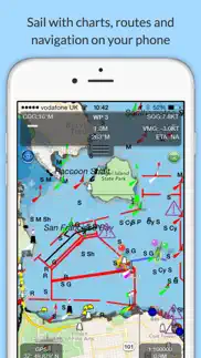
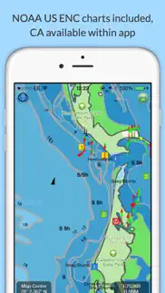
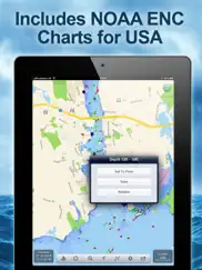
What is seanav us app? Explore, Plan and Navigate your boating trips in real time and outstanding high-resolution with the latest NOAA Marine charts covering the whole of the USA and US Great Lakes.
- Includes all US Coastal, Inland and Great Lakes Digital Vector Charts
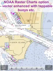
- Buoys, lights etc. are tappable with bearing and distance
- Free Apple Watch app
- Seamless panning and zooming across charts
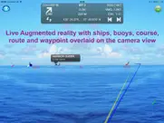
- Unique live Augmented Reality camera view
- Route Planning and tracking with Waypoints, ETA, XTE, etc.
- Offline charts
- Route export and import
- Live AIS Ship targets (requires Boat Beacon)
- ActiveCaptain Marinas, Anchorage, Hazards and reviews
- US NOAA Raster charts available via IAP
- Canadian charts via IAP
- External NMEA over Wifi
SeaNav is a Universal app, which works on iPad, iPhone and iPod.
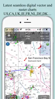
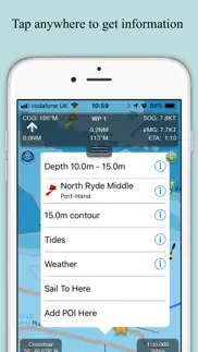
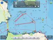
SeaNav uses Digital Vector charts providing a wealth of benefits and advantages. Buoys, Lights, Bridges, Depth Contours, Depth Soundings, Rocks, Anchorage areas, NOAA Weather Buoys etc. are all selectable and have real time distance, bearing and detail information. Turn off layers to de-clutter the display and only show what is important at the time. Tides, moon and sun times and weather are also all available at your fingertips.
SeaNav’s unique AR view mode allows you to view buoys, lights, ships, waypoints and track overlaid on your iPhone or iPad live camera view. With "AR LockOn" you can select a target on the chart and then be guided to it in the AR camera view.
SeaNav lets you measure distances and bearings and record waypoints on routes. When at sea, the app’s Sailing HUD shows your position, Course over ground (COG), Speed over ground (SOG), Vector Made Good (VMG), Estimated Time of Arrival (ETA), Distance and bearing to next Waypoint. Waypoint reached alerts, auto-routing to the next waypoint and collision alerts.
SeaNav has free Apple Watch and Pebble Smartwatch apps available.
Lowrance, Simrad and B&G GoFree support included.
Your purchase of SeaNav includes 12 months of free updates to the included US chart set. Further chart updates are then available via an in-app purchase. Charts for other regions including Canada may also be added to your product via optional in-app purchase.
Our in-app purchases are 1 year subscriptions, which automatically renew at the end of the subscription period unless auto-renew is turned off at least 24-hours before the end of the current period. Payment will be charged to your iTunes Account at confirmation of purchase, and will be charged for renewal within 24-hours prior to the end of the current period. Pricing for our 1 year US Charts update subscription is US$9.99.
Subscriptions may be managed by the iTunes account holder and auto-renewal may be turned off by going to Account Settings after purchase.
No cancellation of the current subscription is allowed during active subscription period.
Our Privacy Policy may be accessed via http://seanav.net/privacy.php
Requires iPhone or iPad. GPS only required for real time route navigation. Optional Real time AIS, Tides and Weather information require an active internet connection.
iPhone devices and iPads with a cellular modem already have a built-in GPS, even if they do not have an active service plan.
If you have a WiFi-only iPad or iPod you will need an external GPS receiver or GPS feed to enable navigation.
Please note that continued use of GPS running in the background can dramatically decrease battery life.
NOT FOR NAVIGATION
This program is distributed in the hope that it will be useful. SeaNav should only be used for basic navigation reference and should not be solely relied upon to determine precise locations, proximity, distance, or direction.
Terms of Use: http://seanav.net/termsofuse.php
Privacy Policy: http://seanav.net/privacy.php
Support: help@pocketmariner.com
Third Party Licenses and Notices
NOTICE: US Marine Charts are derived from official NOAA Electronic Navigational Charts.
😍 Do you love SeaNav US app? Please share your friends!

Please wait! SeaNav US app comments loading...
SeaNav US 5.4.5 Tips, Tricks, Cheats and Rules
What do you think of the SeaNav US app? Can you share your complaints, experiences, or thoughts about the application with Pocket Mariner Ltd. and other users?
SeaNav US 5.4.5 Apps Screenshots & Images
SeaNav US iphone, ipad, apple watch and apple tv screenshot images, pictures.
| Language | English |
| Price | $19.99 |
| Adult Rating | 4+ years and older |
| Current Version | 5.4.5 |
| Play Store | com.electricpocket.seanav.us |
| Compatibility | iOS 11.0 or later |
SeaNav US (Versiyon 5.4.5) Install & Download
The application SeaNav US was published in the category Navigation on 18 April 2013, Thursday and was developed by Pocket Mariner Ltd. [Developer ID: 719592131]. This program file size is 41.33 MB. This app has been rated by 74 users and has a rating of 4.3 out of 5. SeaNav US - Navigation app posted on 10 January 2024, Wednesday current version is 5.4.5 and works well on iOS 11.0 and higher versions. Google Play ID: com.electricpocket.seanav.us. Languages supported by the app:
DA EN FR DE ES Download & Install Now!| App Name | Score | Comments | Price |
| Boat Watch Pro Reviews | 4.5 | 66 | $7.99 |
| Boat Watch - Ship Tracking Reviews | 4.5 | 2,456 | Free |
| Boat Watch Pro Reviews | 1 | No comment | $6.99 |
| SeaNav Reviews | 4.3 | 185 | Free |
| Boat Watch Reviews | 1 | No comment | Free |
Fix for updatable charts that have not been updated not displaying if SeaNav is not connected to the internet.
| App Name | Released |
| PlugShare | 07 March 2011 |
| Neshan Map | 04 May 2023 |
| KakaoMap - Korea No.1 Map | 27 February 2009 |
| Bonjour RATP | 14 May 2012 |
| Find my Phone - Family Locator | 08 January 2013 |
Find on this site the customer service details of SeaNav US. Besides contact details, the page also offers a brief overview of the digital toy company.
| App Name | Released |
| Bronx Zoo - ZooMap | 16 May 2021 |
| Solocator - GPS Field Camera | 09 December 2012 |
| Topo Maps | 26 March 2009 |
| Holding Pattern Trainer | 16 August 2011 |
| StarPilot | 03 March 2010 |
Discover how specific cryptocurrencies work — and get a bit of each crypto to try out for yourself. Coinbase is the easiest place to buy and sell cryptocurrency. Sign up and get started today.
| App Name | Released |
| Hive Social | 18 October 2019 |
| Netflix | 01 April 2010 |
| 06 October 2010 | |
| 07 April 2016 | |
| 28 April 2011 |
Looking for comprehensive training in Google Analytics 4? We've compiled the top paid and free GA4 courses available in 2024.
| App Name | Released |
| TV Cast Pro for LG webOS | 23 June 2016 |
| Paprika Recipe Manager 3 | 15 November 2017 |
| Slay the Spire | 13 June 2020 |
| The Wonder Weeks | 30 May 2012 |
| Stardew Valley | 24 October 2018 |
Each capsule is packed with pure, high-potency nootropic nutrients. No pointless additives. Just 100% natural brainpower. Third-party tested and validated by the Clean Label Project.
Adsterra is the most preferred ad network for those looking for an alternative to AdSense. Adsterra is the ideal choice for new sites with low daily traffic. In order to advertise on the site in Adsterra, like other ad networks, a certain traffic limit, domain age, etc. is required. There are no strict rules.
The easy, affordable way to create your professional portfolio website, store, blog & client galleries. No coding needed. Try free now.
SeaNav US Comments & Reviews 2024
We transfer money over €4 billion every month. We enable individual and business accounts to save 4 million Euros on bank transfer fees. Want to send free money abroad or transfer money abroad for free? Free international money transfer!
Awesome!. This app saved us last night in the fog. Got home safe thanks to this excellent app!
Unusable. The charts draw soooooo slowly, this app is virtually unusable.
Nice improvements. They keep working on this app and its become much better, performance is good on my iphone 5
Too slow and crash prone. It crashes about half the time thus far
Exceptional. Love the look and feel of the charts. Easy to read. Zoom in and out makes my onboard Raymarine software/equipment a relic. Use in conjunction with Boat Beacon (app). This will give you real time AIS!
Crashes!!!. when you set sail to a point it crashes and then you have to start all over. Adding spots should be simple but its not, (you should be able to tap in boat position and add your fav spot), zoom in out is app took a time to load or freezes!
Too basic. This app offers little more than a colorful map with a few icons. It is of zero use in navigation.
AIS fan. Great app for viewing ships in Los Angeles harbor.
Good app but NO detailed depth contours for Tennessee River. I give it 5 stars because it is an intuitive app, and if you do any type of weekend trip on a cabin cruiser near the major bays, it's probably fine. I like the fact that it pings GPS every minute when in background mode to save energy. I like the intuitive interface, and myriad options one can set. Their tech support is great. I've been emailing them and they have done all they can to work with me, and even suggesting a refund. I appreciate a company like this but I did ask them to update their description to make sure people know about the Tennessee River depth contour issue. I bought a competing app after I bought SeaNav and I initially considered refunding the SeaNav but I like it enough reasons to keep them both. I'm not a pro but I have spent a lot of my life in twin engine Chris Craft cruisers as well as little runabouts. I keep laminated official marine charts and realize these apps are no substitute for charts. I CANNOT RECOMMEND THIS APP FOR THE TENNESSEE RIVER, particularly for its lack of detail upriver from Pickwick Dam (Pickwick Lake towards Wilson Dam) and lack of more detailed depth contours. There are underwater stumps galore and you must stay in the channel you need to follow. SeaNav does not show a route and does not label any of the obstructions - even though it would probably be impossible to pinpoint them all. I bought this app for the depth contours that showed up in the preview images, thinking they would be on all US waterways. Seems their map source does not offer those, so I get only two depth contours on the Tennessee River through North Alabama: >9ft and <9ft. Seriously. Inaccurate rendering of depth contours even in slews that are 20+ feet deep it is a blue color representing <9 ft deep. We do a lot of activities in our runabout in shallow slews and also a couple miles up from the mouth of the Elk River. The mouth of the Elk River has channel markers but this app does not show a route through that channel. The river renderings stop after you leave the main Tennessee River. Elk River on Wheeler Lake? forget it. Shoals Creek on Wilson Lake? forget it. Bear Creek on Pickwick Lake? forget it.
Not user friendly. Very difficult to use but have heard good things from other Captians
Crashes frequently. I am running this app on an iPhone 5 with iOS 7. Since purchasing I haven't been able to use the app due to it crashing every time I open it. Please update your app to work with the new iOS or remove it from the App Store if you cannot support it.
Amazing app. This app is truly amazing. It automatically couples with other apps, like the AIS beacon app, et al.
Very good navigation app. I’ve used SeaNav and Boat Beacon for six years, extensive offline use in British Columbia and Washington. Of the six or seven IOS marine navigation apps I’ve owned, it’s the best and most enduring. Well maintained and very responsive tech support.
Snappy and helpful. The app is crisp and responsive on my 4th gen iPad -- and the AR feature was a huge help in confirming landmarks while sailing through the fog along the Monterey coast.
Misleading. App is suppose to cover all US charts yet none of the lakes in my area show up. In fact, none of the lakes in my state show up, and we are talking some rather large bodies of water. The only body of water to show up is a floodplain called little blue river which isn't even navigable, lol. App should correctly read only select US bodies of water, not ALL U.S. charts. Waste of $10. Navionics is much more complete.
Crashed 5 times in the first 15 minutes - Yuk. Crashed so often that I couldn't even view harbors. Vey allow on my LTE iPad Mini. Depth contours 0-18', 18-30', and 30-600'are less than ideal. I would want to navigate my boat using this app and its maps.
Waste of money can’t get a river depth it old version was free. Google maps is better
SeaNav. Works best on iPad 3 with cellular/wifi as this iPad 3G has a GPS assisted capability whether connected or not to a cellular network. IPad 2 wifi (no cellular) dees NOT have a GPS Satellite Receiver in them so you would need to add a GPS receiver to an iPad 2. I tried using a Verizon Hot Spot Cellular with iPad 2 and neither worked, nor did Apple Maps or Google Maps. There are no cellular towers in the middle of Lake Michigan, so the triangulated cellular cannot function on a iPad 2. You end up sliding along the shoreline and never go out into the Lake. The same problem happens with Apple Maps and Google on an iPad 2 with wifi. Apple Tech Support acknowledges that they are having problems with Apple Maps and today acknowledged issues reported with SeaNav and BoatBeacon, both sold through their AppStore because of the lack of a GPS receiver in the iPad. I took back my iPad2 wifi and picked up a iPad 3G which allows SeaNav & Boat Beacon to work out on the water. The Technical Support and Management at SeaNav/Boat Beacon provided excellent support and personal attention to my concerns and answered all my help requests. A+
Self. Purchased app yesterday and initially worked perfectly, then my iPad wouldn't show position on SeaNAv. Strange. I emailed Steve Bennett @ Pocket Electric (the developer) and I had an email back from him this morning. There's a known bug in the llatest bersion of iOS software that prevents the iPad from accepting location from the extenral GPS (in my case, a Dual). The fix is on the iPad: (1) turn off location services on iPad; (2) reboot iPad; (3) wait 5 seconds and turn iPad on; (4) turn location services on. This may need to be done whenever the problem reappears. Let's hope Apple fixes this soon. Anyway, the SeaNav app is outstanding and a real bargain for the recreational boater, in my opinion. And the quick, accurate and friendly tech support seals the deal for me!
Hard to navigate. Hard to use
Very cool app!. I also have boat beacon that overlays AIS data on these nautical charts and its great to watch, especially during meetings when you'd rather be on the water :)
Crash. Will not run on my 124g iPad3 more than two minutes before crash.
Slow to the point of being unusable. The slightest move on the chart causes a 5-20 second wait for the map to redraw itself. Zooming out makes the map unreadable for at least as long. Simplifying the map only helps a little bit...still too slow to use. The charts are way too busy graphically speaking-very hard to even find a channel with giant marker icons. The only good thing is that is coordinates with boat beacon, a very good app. Get Navionics. 1000 times better.
Awesome app. Huge fan of this app. Really easy to set up. Easy to use. Very functional. The app has a lot of great features. I holy recommend this app
Needs work. It would be a great app IF it would use iPad internal gps. At the moment it requires you to connect to external gps! How stupid is that?! I used version of this software back on PC. Back than I understood need of external gps. Not theses days. Please fix it. Meantime I will stick to iSailor.
Not for iPhone!. I sail Alamitos Bay in Long Beach, CA. Although I have Anchorages layer OFF, the chart still indicates all anchorages. So many are shown that they overlap and are unreadable. On my iPhone 6 Plus, the chart is useless. Tech support claims that the anchorages are the names of the 'water areas' and will show even with the Anchorages layer turned OFF. $30 bucks out the window, as far as I'm concerned.
Poor & slow. Crash & calibrate,seems that's all I do with this app. This app is not even good for recreational boating. Don't waste your time & money.
Did you know that you can earn 25 USD from our site just by registering? Get $25 for free by joining Payoneer!
Imagine you at your best. All the time. Picture yourself at your sharpest and most productive. Your most alert and focused. Your most lucid, creative and confident. At work. At play. In every area of your life. Add Mind Lab Pro® v4.0 to your daily routine and uncap your true potential. Buy Now!
Adsterra is the most preferred ad network for those looking for an alternative to AdSense. Adsterra is the ideal choice for new sites with low daily traffic. In order to advertise on the site in Adsterra, like other ad networks, a certain traffic limit, domain age, etc. is required. There are no strict rules. Sign up!