FarOut Guides App Reviews
FarOut Guides App Description & Overview
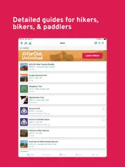
What is farout guides app? Embark on the adventure of a lifetime with FarOut, the most reliable navigational guide app for long-distance exploration. With over 200 hiking, biking, whitewater rafting and paddling navigational guides around the world, FarOut has everything you need to blaze your owns trail.
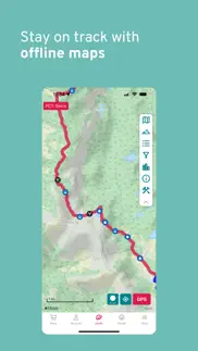
Whether you're scaling the highest peaks or exploring the wildest rivers, FarOut provides you with trusted, official trail data even when you're offline, so you can explore with confidence. And with our Check-in feature, you can keep your loved ones in the loop by letting them know exactly where you are and that you're safe.
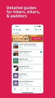
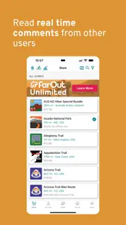
Subscribe to FarOut Unlimited and get access to all of our navigational guides, which covers over 50,000 miles. Our monthly, annual, and 6-month Season Pass plans give you the ultimate flexibility to explore the world on your terms. Or if you prefer to own a single guide forever, you can make a lifetime purchase. With FarOut, the choice is yours.
Join the hundreds of thousands of adventure enthusiasts who have already experienced the benefits of FarOut. Whether you're hiking, biking, whitewater rafting or paddling your way around the world, FarOut is your ultimate guide to unforgettable experiences. Download FarOut today and start your next adventure!
KEY FEATURES:
1. Extensive coverage: FarOut includes guides in popular long-distance hiking, biking, rafting, and paddling routes worldwide, including the United States, Australia, Canada, the UK, Europe, New Zealand, the Middle East, South America, and Central America.
2. Trusted, official trail data: FarOut partners with dozens of trail organizations, book authors, and publishers to provide official, up-to-date trail data that you can rely on.
3. Check-in feature: FarOut's Check-in feature allows you to let your friends and family know exactly where you are, providing peace of mind for both you and your loved ones.
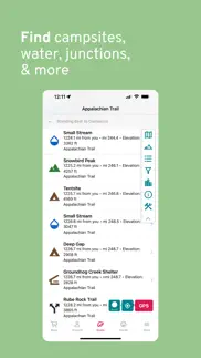
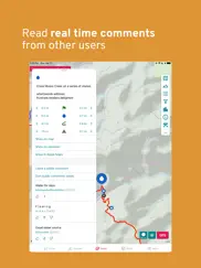
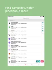
4. Comprehensive waypoint information: FarOut provides everything you need to know on the ground, such as junctions, water sources, road crossings, portages, launch sites, trailheads, town guides, and much more.
5. Flexible purchasing options: You can subscribe to FarOut Unlimited and get access to all navigational guides, or you can purchase a single guide as a lifetime purchase. The choice is yours.
😍 Do you love FarOut Guides app? Please share your friends!

Please wait! FarOut Guides app comments loading...
FarOut Guides 12.3.3 Tips, Tricks, Cheats and Rules
What do you think of the FarOut Guides app? Can you share your complaints, experiences, or thoughts about the application with Atlas Guides DE, Inc. and other users?

FarOut Guides 12.3.3 Apps Screenshots & Images
FarOut Guides iphone, ipad, apple watch and apple tv screenshot images, pictures.
| Language | English |
| Price | Free |
| Adult Rating | 12+ years and older |
| Current Version | 12.3.3 |
| Play Store | com.guthookhikes.ATHiker |
| Compatibility | iOS 15.0 or later |
FarOut Guides (Versiyon 12.3.3) Install & Download
The application FarOut Guides was published in the category Navigation on 08 March 2013, Friday and was developed by Atlas Guides DE, Inc. [Developer ID: 503652260]. This program file size is 174.36 MB. This app has been rated by 21,305 users and has a rating of 4.8 out of 5. FarOut Guides - Navigation app posted on 06 February 2024, Tuesday current version is 12.3.3 and works well on iOS 15.0 and higher versions. Google Play ID: com.guthookhikes.ATHiker. Languages supported by the app:
CS EN Download & Install Now!| App Name | Score | Comments | Price |
12.3.3: Introducing a new app feature called Field Reporting! Now you can suggest new waypoints to be added to the app or report conditions in the field by creating a custom waypoint, report any errors you notice on waypoints or comments, and flag inappropriate comments, etc. Try it out! Bugfixes: - Improvements to Elevation Profile - Fixed display issues with Elevation Profile - Fixed waypoints displaying incorrectly on Elevation Profile - Custom routes now show up for all guides in profile view - Fixes for data syncing and file manager - Fixed a crash caused by quickly downloading multiple guides - Fixes for bugs when switching between guide view types - Certain Area Infos now display correctly
| App Name | Released |
| Spoten Phone Location Tracker | 06 December 2018 |
| Electrify America | 03 June 2019 |
| EVgo EV Chargers | 17 October 2017 |
| Premium Parking | 22 October 2013 |
| NAVER Map, Navigation | 01 May 2009 |
Find on this site the customer service details of FarOut Guides. Besides contact details, the page also offers a brief overview of the digital toy company.
| App Name | Released |
| IMotoneige | 02 December 2017 |
| Villages GPS | 02 December 2013 |
| MapOut | 19 March 2012 |
| NZ Topo50 South Island | 27 February 2013 |
| Land Nav Assistant | 18 May 2012 |
Discover how specific cryptocurrencies work — and get a bit of each crypto to try out for yourself. Coinbase is the easiest place to buy and sell cryptocurrency. Sign up and get started today.
| App Name | Released |
| Delta - Game Emulator | 17 April 2024 |
| 06 October 2010 | |
| DoorDash - Food Delivery | 10 October 2013 |
| X | 09 October 2009 |
| SHEIN - Shopping Online | 19 May 2014 |
Looking for comprehensive training in Google Analytics 4? We've compiled the top paid and free GA4 courses available in 2024.
| App Name | Released |
| 75 Hard | 19 June 2020 |
| Incredibox | 27 March 2016 |
| Papers, Please | 12 December 2014 |
| MONOPOLY | 04 December 2019 |
| Procreate Pocket | 17 December 2014 |
Each capsule is packed with pure, high-potency nootropic nutrients. No pointless additives. Just 100% natural brainpower. Third-party tested and validated by the Clean Label Project.
Adsterra is the most preferred ad network for those looking for an alternative to AdSense. Adsterra is the ideal choice for new sites with low daily traffic. In order to advertise on the site in Adsterra, like other ad networks, a certain traffic limit, domain age, etc. is required. There are no strict rules.
The easy, affordable way to create your professional portfolio website, store, blog & client galleries. No coding needed. Try free now.
FarOut Guides Comments & Reviews 2024
We transfer money over €4 billion every month. We enable individual and business accounts to save 4 million Euros on bank transfer fees. Want to send free money abroad or transfer money abroad for free? Free international money transfer!
Awesome Waypoint Feature Update. Guthook has been my go-to app for AT hiking since day one!!! I even carry the printed guide as backup for the phone. I opened the app for the first time in a while for my next hike and was very pleased to see such a useful feature update in an already amazing app. The only thing I would ask for is it would be nice to be able to display distances between waypoints with the starting waypoint set to zero. See, I use routes to plan the section and waypoints to break the section up into daily goals. It would be very useful to surface data on my progress through the day. I know I could create a whole new route for each day of the hike but this makes it more difficult to see the big picture of overall progress. It would be great to see the overall section broken down into easy to view daily goals in a similar way as the full route. Kinda like, mini or, sub-routes.
Hiking the AZT. Before Guthook had developed the AZT trail guide, my husband and I were section hiking it. There were many times we would come to unmarked areas where the trail might head off in various directions or be overgrown and vague. We would inevitably head the wrong direction, note within a mile or so no signage, get out a map and try to figure out where we went wrong. Obviously this led to much backtracking and grumbling. Now I simply pull out my phone at a questionable spot, open the Guthook map, walk ten or so feet one direction or other and visually see my Guthook marker moving on or away from the trail. It is a lifesaver in many ways! Thanks Guthook crew for making life on the trail a great adventure without the grumbling!
Usually Amazing but stopped working. I love this app, and I would normally rate it 5 stars however it is not working at the moment. I cannot view my saved routes or load points of interest (peaks, campgrounds, trailheads, etc) on the map, and cannot create new routes. This app has always worked very well, but suddenly stopped! Once this is fixed, I will be happy to change my review and rating to 5 stars, because when it was working it is definitely worth it! I’d be happy to send along more info and screen recordings to developers. Update: the app is working normally on my iPad, just not my iPhone.
Excellent app with bugs. This is a brilliant app, but there are a few annoying bugs. Saved routes that are deleted randomly come back and never stay deleted. As a planner and a section hiker after I complete a saved route not being able to delete is a bit of a pain. Otherwise really great app and being able to see other hikers comments about a location or spring is exceedingly helpful. Definitely worth the purchase, but wish the deleting routes issue would be resolved. Only reason for not 5 stars honestly.
Tried and Trusted. I hiked the PCT in 2018 and the TRT in 2019 using Far Out Guides (Guthook back then) and it is by-far the most updated and reliable way to navigate on long trails. Anything from water reports to what towns to resupply in, all the info you need is here. Part of this app staying updated to due to the user comments, which have proved to be an excellent source of updates and valuable info for your long hike. The information provided by users not only keeps you informed, but also helps users in the future and gives a snapshot of what changes from year-to-year on a trail. I also want to highlight the customer support teams quick reply’s and clear instructions. I had a problem downloading a previous purchase from a few years ago and was able to get quick support to get access to that trail again.
Good… but very easy to make better. I really like this app. I’m using it for Appalachian Trail (AT) section hiking. It is simple to use, and has many useful features. My one complaint is the inconsistent treatment of trail intersections. Because I am an AT “section” hiker, identification of AT trail intersections is very important to my hike planning and on-the-trail re-planning. FarOut is very complete in listing major AT trail intersections in some AT sections… but oddly… shows hardly any trail intersections in other sections, including for some of the most popular and rugged parts of the AT. I find this frustrating… and requires me to reference and bring other maps along when hiking some portions of the AT. Fortunately… this is a very easy fix. These intersections are well documented in the AT maps published and maintained by the various AT chapters. I hope FarOut will fix this quality issue (consistence conformance to standard) by adding waypoints to show ALL major AT trail intersections.
Appalachian Trail. Used the Guthook app while hiking the AT in 2017 and was extremely satisfied with it. Everything in one easy to use accessible package, worked well on my iPhone. The people at Guthook continued to update and improve on the app as I used it. Bugs were addressed and fixed quickly, waypoints, resupply, water sources were at the location the app said they would be. Would recommend, and have recommended this app to anyone thinking about hiking or section hiking the AT. My satisfaction and trust in the people at Guthook has me returning for an app to take on the Arizona Trail and I hope an app for the PNT is released very soon. NNoHurry
World Class Hiking App!. FarOut long trail hiking products are the very best for novice and experienced backpackers alike. They are simple, reliable detailed maps with everything a backpacker needs for a successful hike. The maps are routinely updated to ensure accuracy and saved me a couple times when I wondered off trail on the PCT while not paying enough attention. The embedded trail alerts and user generated reports on water sources and camping are invaluable. I have hiked many times with and without FarOut map products on various trails. If they are available for your hike, pay the very reasonable price and don’t set out without FarOut in hand. One more thing, their tech support is second to none. I needed to have my account reset and several of my previously purchased hiking products reloaded to my account and tech support (Kevin) got right on it and gave me the personalized attention that companies rarely provide in the post Covid world. I was up and running again in no time. These guys are the best! Thanks FarOut.
Lifesaver!. What a difference this app makes on a thru hike! Although it does take away a bit of the spontaneous adventure out of a hike, it’s more than necessary for the modern interpretation of a thru hike. Being able to plan out your day with accurate up to date information makes it possible to push all the way until dark and not worry about water or a flat spot to camp. The aspect of a community is also great with the ability to easily add your own input and look back on what previous generations of hikers had to say. You’ll see some sweet hidden gems along the trail because of this! I love the concept for the big trails, and I won’t ever attempt a thru hike without something like it. However, I give 4 stars because there is still a lot of room for improvement. Even in the couple years I’ve had the app they’ve made some good changes, but it still feels a bit awkward navigating through the app on occasion and some features feel a bit lazy. I’m sure as more and more folks start to flood the trails who are used to the constant influence of technology the app will feel pressure to change. Overall it serves the purpose great, and the GPS feature could literally be a life saver. Just don’t get too caught up in the constant updates on mileage.
Buggy & zero responsibility taken. iPhone users (at least on the Pacific Crest Trail right now) have been having a terrible time FOR OVER A MONTH trying to use their maps. FarOut continues to blame an Apple update, but no other map application is having this problem except them. It seems to only happen if I attempt to look for cell phone service, get none, and the app is running in the background. Feels like they aren’t fetching data in a standard way if an update only broke their map (nor other map apps).
Offline Connection Faulty. Overall the app offers a great experience. I have purchased all the PCT Apps and used for many years without issue. This year during my 12 day section hike I found 2 significant issues 1. I was hiking from Oregon into California. I had no cell service, I was unable to switch maps from Oregon to Northern California without cell service. The maps were fully downloaded. In other words you can’t change maps without service anytime. 2. While hiking if you leave the map open and turn off airplane mode to check for cell service, get service then turn it off, you loose detail inder one mile visibility. The map goes to grid lines only when you zoom in. This will not be restored until you find phone reception, connect with the app open and close before turning back on airplane mode. This would not be an issue if you were hiking in the city but when you are in the woods with limited phone reception it becomes a big inconvenience.
AT Section Hike Essential. Using this app exclusively, I’ve now section hiked three states on the Appalachian trail. During planning, it’s helped me visualize every single day - down to the minute, mileage, elevation and water stop. When I’ve gone off-trail, it’s pointed me in the right direction, and when I’m tired it’s been my motivation, knowing exactly how many miles there are to the next waypoint. It’s also kept me safe because I know exactly where water, shelter, and towns are, and it’s reliable as ever. I even had momentary issues with the app, and the creator himself was writing me, making updates, and genuinely wanted to help. I carry a back-up map of course, but this app is truly all you need to get out and hike.
Get it fo sho. After thru hiking the Appalachian Trail with guthooks, I realized that I don’t ever wanna thru hike another trail without it. It gives you a sense of security, knowing absolutely where you are and if water is ahead. I loved being able to click on waypoints to read comments about everything! You can see what other real users have to say about camping/shelters, roads, hostels, where to eat, water sources etc. I can’t say enough about this app, except that I 100% stand behind it and you should too. -Taco ‘18
Great hiking App. Guthook/FarOut is amazing App and a must have for any of the trail it covers. Makes it so much easier to plan for camping spots and water refills. You can find the elevation gain for each trip/day. You always know exactly where you are and how far to camp or water. And if by just you accidentally get off the trail you can find the direction back to the trail. It great, but I feel the latest update made it more difficult to filter the waypoints when just looking for water or campsite.
Guthooks saved me from the Bears!!. I’ve loved the app for years. Download the app, buy your favorite trails maps and keep them forever! Their customer service is truly excellent! Guthooks is easy to use and has incredible amounts of truly valuable information for the hiker and backpacker. Mileage, elevation, distance between waypoints like water sources and campsites all help in planning my trip. One source of information that surprised me with its tremendous value was the user comments. While planning a recent trip, I had a choice of campsites, and while reading the user comments on each, I found multiple comments from the week before regarding the high level of aggressive Bear activity around one. So I chose the other and slept well!
All You Need To Hike The AT. I retired on 31DEC20 and I started hiking the AT on 14FEB21. In preparation for the hike I loaded my phone with Guthook, All Trails and Garmin Earthmate (synch’d to phone). I am two months and 600 miles into the trail. Of the thee apps I have on my phone Guthook far and away is the most helpful. The app is so well designed that it is easy to use with very little familiarization. The distances are trail distances and not crow flies distances, the elevation profile view lets you know what will be hard and what will be easy. The app shows you all options for shelters, towns, hostels, water sources and much, much more. The customer service is fast and responsive if you have a question. You will never regret buying the Guthook app if you plan to hike the AT. Snorezilla, 2021 NOBO Thru Hiker
Water Seeker. I hiked 1,000 miles of the AT earlier this year and got Guthook about halfway through. The comments are what really make the app so useful. Commenters will tell you where common water stashes are, the recent state of springs, and small shops near road crossings that aren't listed anywhere else. There were a few times when water was hard to come by and having a heads up that the next 3 listed water sources were dry really helped me to know when I needed to carry extra water or when I could expect to fill up at camp. Great tool.
This App Is Not Reliable For Navigation. App does a great job of showing you where places are along the trail, water, camping, lodging, etc but I have lost the trail or the red line on this app multiple times & sometimes at the most crucial of times. Do not count on this app as your only mode of navigation. The only way you can restore trail on map is to get to Wi-Fi & delete & redownload app. Garmin In Reach maps have been the only maps that have been reliable throughout the entire length of the PCT. FarOut could be a good app but I gave it 2 stars for its lack of reliability on the IPhone. Very frustrating & could be, should be a safety concern.
Must have! + great customer service. There’s just a lot to say about this brilliant app. I don’t even know where to begin. It’s proven itself so useful that it’s become indispensable. When you’re out there, you need this app, it is a must have. 👍🏼👍🏼👍🏼 There also isn’t much I can say that hasn’t already been said. My favorite thing about it is that you can literally gauge and predict (per your own judgement and risk) water flow, by reading comments left by people who are ahead of you. My least favorite thing is reading comments left by people who had bad experiences and it scares me 😩😆 User interface could use some improvement. Though it’s already improved quite a bit since I used it in 2019. Not bad where it’s at now. Shout out to team to keep up the good work 💪🏼 I needed some help today and their customer service is just 👌🏼🥰
Guthook Pinhoti Trail app. Ryan and all at Atlas Guides, Folks had been daily asking me for a map of our trail complex here on Flagg Mountain. Flagg is the southern terminus of the Pinhoti Trail, the beginning of the Appalachian Mountain Range, a very popular place for day hikers and backpackers here in Alabama. As a member of the Alabama Hiking Trail Society, I serve as the official caretaker here for the Alabama Forestry Commission. Until your app became available, I had no way of helping folks hike the mountain. But that's all changed now, thanks to the Guthook Atlas Guides Pinhoti Trail app! Folks can quickly review our loop trails, choose how they'd like to spend a few hours--or a weekend. You've literally put us on the map, Ryan; thanks!
Works great. Guthook was recommended by so many legitimate hikers that I wasn’t too worried about the functional side of it. I was concerned that it might be more than I need or want which it definitely is. (But not in a bad way) I don’t need to post or check in. I have low vision and can no longer count on my vision to navigate correctly. Since a compass and map don’t work well for me anymore I bought and downloaded the Maine trails and it works like a champ. Having an accurate GPS location and with the mileage is awesome. I imagine sighted people could use this app too. Lol
Modern hiker must. Guthook is the most popular trail navigate app on the Appalachian Trail, as far as I can see. It works well for knowing shelter, campsite, water supply, wayside, view, and road locations. The public comment section of these locations keeps hikers updated on conditions, including water availability, bear sightings, trail conditions, etc. If one deviates from the trail, Guthook quickly shows where the mistake was made and how to get back on the trail. Since Guthook can be run in Airplane Mode, battery usage is optimized. My brother and I alternated days running it on our phones, which further helped with battery use efficiency. Overall I recommend using Guthook.
Features Good, an issue though. Used this on a 600 mile section hike of the AT. The level of detail helped me significantly plan out every day with a lot less stress, and knowing where you were at all times was very helpful. However, there is an issue with storage. The app keeps increasing the amount of local storage it is using without me downloading anything new (for instance, despite not using the app for weeks, I had found today that FarOut had increased its local storage by 170MB). In addition, when you delete local maps or other data, the amount of used storage rarely, if ever goes down. Edit: now up to over 350MB despite barely using the app and having close to nothing downloaded.
No support on website version. Recently bought PCT but very very challenging to make planning based on app itself. It’s good that you have website version but after multiple attempts I fail to login to website version. I add user ID /PW when I click on login button nothing happens. I rest password thinking maybe PW issue but despite of changing PW still no luck getting the website. And I cannot use the app unless I plan ahead, your app may be the best for folks on trail but I feel impaired b/c if I can’t plan ahead I may have to drop off my PCT plans. Any fix you would like to suggest? I sent bunch of emails and no response from your side
Great app but still room for improvement. Let me start by saying this app will get you through the entire AT without trouble. The only thing I would change would be to add the ability to create custom waypoints to save on your adventure. This is mostly because there were lots of camping and water supplies we came across that were not listed that will could be hard to find again when trying to go back and visit favorite spots on the trail. Another instance I could see it helping would be when you come across areas that are reroutes around bridge washouts or Bees nests. Even without this ability, this is still very much worth the cost of the maps.
The Best!. Anything I can do to get this app a 5-star review is worth my time. Everything from the ground up, from the original idea to how well it works on trail is life-changing on the trail and even in the planning stages. I come from 25 years of thru-hiking experience. My hiking days began with National Geographic articles, carrying guide books on trail, and then Halfmile’s maps were a constant companion on the PCT, until the Colorado Trail in 2015. That was my first Guthook experience and it was incredible. In an instant, I was able to see exactly where I was on trail, where the water was or wasn’t, and even the best places in towns in more or less real time. I like the social aspect somewhat, more for the information I really need. I hope Atlas expands to include more trails- while realizing that lesser known trails are less traveled and the return on investment might not be warranted. But there’s a space on my phone for a Guthook on a thru-hike no matter how how short or long, a thru is a thru- my money and yours is well spent within this app.
App worked great last year. Now is utter crap. Completely unusable.. The map disappears when you try to zoom in close. They’ve changed all of the mileage halfway through hiking season so none of it matches the official mileage from the PCTA. The user comments randomly disappear. I said I have no idea what causes them to come back, but sometimes they are just completely gone. The GPS arrow does not point in the direction you’re headed anymore. And to top it off all of the Maps I have purchased this year are no longer available in the “my purchases” section on the App’s “Store” so I have to navigate to them from the long list of available maps. I’ve reached out regarding these issues and for a refund due to faulty product, but their customer service representative has informed me that apple does not allow them to give refunds. Furthermore, fixed all of the aforementioned issues with their most recent update. However, my app is completely up-to-date and all of the issues remain. I would highly recommend any hiker considering navigation apps choose a different product than far out.
Outstanding App. Outstanding is the word for Guthook! The support team is also beyond question, they were exceptional! I started my (eventually failed) thru hike without Guthook. Everyone that I met on the AT—-both thru and section hikers—had the app! During my first “zero” in a hotel with good WiFi, I purchased and downloaded it. Back on trail, it was a night and day difference. It eliminated so much of the mystery that challenges thru hikers initially! Best resupply, water sources, etc. I still carried my AWOL...and used it at night to conserve battery power...but once on Trail, I referred exclusively to “the Hook”! And the value of the interactive comments from other hikers cannot be discounted! This year, I hope to get back on the AT.... I also find the Guthook a great planning tool.
Best App for Southern Sierra and JMT. I really was glad I had this App for my 15 day PCT/JMT hike. Our itinerary had our campsites located by mile number on the PCT. This was very easy to find on the App. I initially had some difficulty downloading the App. Tyler Lau, Atlas Guides customer service, helped me. Then while I was on the trip I had trouble with some of the functions. On my one zero day with Internet access, Tyler Lau helped me again, responding quickly to my request knowing that I was going back on the trail. Evidently there was an IOS glitch that has now been fixed. I used the App everyday to find our campsite, water sources & just to make sure I was on the correct route. I also used it exiting over Kearsarge Pass. I highly recommend this App. And, most importantly, it has the BEST customer service & help. Thank you!
Good app with bad name. I’ve used this app for my hikes for 2 1/2 years. I love it. It’s a great guide, works without cell service and fellow hikers are constantly updating! But o hate the name & logo change. The original GutHook logo was a better symbol of what the app is. Go back to it! The new logo looks like it ought to be a childrens music app! I never understand the name GutHook but at least it was catchy. Far out is just dumb! If you can come up with an IMPROVEMENT don’t change what you have. Far Out I’d definitely NOT an improvement. Go back to GutHook
Tyler Lau is the bomb!. I have happily used Guthook guides for about 6 years but had never logged into account on my phone as I always got an error message. With a 500 mile sobo coming up next week I wanted to be able to post comments but needed to log in to do so (was using the old app?) Anyway I got Tyler as my support last night and then following through this morning. He was so patient, thorough and gave systematic and explicit directions, trying all possibilities to solve the issues with not one but two devices. I as a not so savvy tech person needed and SO appreciated his help and perseverance. He should get a raise and be celebrated.
Great Price for Peace of Mind. Guthook is the navigation aid for hikers. I was glad to have it doing my recent hike on the Appalachian Trail. The trail is well marked, but there are time when I needed reassurance that I hadn’t stepped off, or that I was going in the right direction. The elevation profiles were great tools to help me plan for the big pushes up and down the mountains. In the Wind River Range, it was a lifesaver as large sections of the trails are unmarked. Guthook saved me several times after I had veered away from the path. Thanks for this app!
Fantastic navigation tool. After watching my friends us FarOut on the JMT I bought and used it on the 500 mile Camino Frances. What a fantastic tool to not only keep us on the right trail but to give us information on resources ahead of us and the mileage to everything we needed. The elevation map was super helpful and the ability to switch back and forth between map views was really helpful. No doubt I’ll use this app for all future backpacking and long distance walking!
Only works if you use it.. On 9-2-21 I stated a 7 day hike of the Big Seki in the Sequoia National Park. The first day and a half the hike is on a smaller trail where I was using a different app. Mid way through the second day the trail I was on merged with the JMT and PCT. I met a thru hiker (NeonTide) who said I should be using Guthook. It was at that moment I remembered I not only had Guthook on my phone but the JMT / PCT were downloaded. Once I started using Guthook it made a huge difference in my hiking game. Not having to guess where reliable sources were or tent sites was a game changer.
AT Thru-Hike (2015). I thru-hiked the AT in 2015 which turned out to be the most amazing experience of my life and I did it with the Guthook App. I cannot recommend it enough for anyone planning to thru, section, or simply car camp the Appalachian trail. In my opinion, this goes on the list of "Don't leave home without it." The AT, at least when I hiked it, was 2,189.2 miles from Springer to Katahdin. Frankly, if you get lost on the AT, you probably don't belong there. So the value of the Guthook App isn't navigation. The reasons I found it to be most useful was to alert me to the elevation that was ahead, distance to shelters and water sources, and road crossings that would take me into trail towns to resupply. I used the Guthook App daily, but I also took along the AWOL AT Guide. I used this to a lesser extent, but I found it equally important. The AWOL guide is an invaluable resource for services along the trail (e.g., shuttles) and in trail towns (e.g., Post Office hours, lodging, etc.) I hope this helps and best wishes on your hike. "Today I begin a new trail in my life. A fresh start. A new beginning. Today I step off the rock at Springer to be transformed because I trust that it is only impossible dreams of this magnitude that will give birth to the type of change I covet." (April 1, 2015) Tabasco
PCT, CT and OT. I recently completed the Colorado Trail using Guthook as my primary navigation aid. Previously I had used it for over 800 mlles on the PCT and also on the Ouachita Trail. This app comes as close to being a perfect hiking tool as one could imagine. It has all the features you need and none of the extraneous junk you don’t. I used it every day. The public comments on the CT are the primary source of water information and every hiker I met counted on them. Great jobs guys!
Cannot rely on this app. I’ve used this app for my thru hikes of the CDT ‘21, PCT ‘22, and now the AT. Currently the app is super buggy, the most critical of these bugs is not loading downloaded maps -any of them- when zoomed in. My partner and I and other hikers on the trail have experienced this glitch. Super sketch for a navigation app. I wish this was my only complaint… my other complaints include outdated info - things closed for 3 years still listed in town guide, zip codes for post offices incomplete, map sections not overlapping making it difficult to plan (sections overlap on the other trail guides), the app randomly glitches and doesn’t show waypoints, the comments on the AT are unhelpful and outdated - seems like some heavy deleting has occurred but I cannot confirm, waypoint info is slow to load, calculated mileage is randomly inaccurate, the elevation plot UX is a nightmare to use. All this is unfortunate bc the app performed great on the CDT and the town and comment info was super helpful. I’d highly recommend downloading a backup map and seeking a more up to date town guide.
My Guide to the AT!. Hockey boy here , to tell you about the Appalachian Trail FAR OUT App. It’s been excellent so far on my section hikes from the Amicalola approach trail all the way to Franklin NC at Winding Stair Gap. I love the heads ups from folks using the App about bear activity, the good and the bad about shelters and most importantly water source updates on water availability on the trail. Not to mention all the information on Hostels shuttles and places to resupply and eat at. The only thing I had any issues was Abandoned trails that seldom get traveled don’t appear sometimes on here, that’s why it’s important to have pocket maps so you can identify them and not accidentally go down them , because of a blue blaze thinking it’s a water source. Other than that I am loving this App,!
Company has stolen all of my past purchases.. If I could give this a rating of zero I would. I’ve spent a couple hundred dollars of the last few years for maps that are suddenly unavailable. I have been told that these cannot be restored unless I provide proof of purchase. After hours online with Apple I have been unable to provide these receipts. Don’t get me wrong the maps are crate and I have used them extensively. That said the company has for the second time changed its platform and put the burden on me to provide proof that I purchased their products in the past.I have so many saved tracks from trips on the PCT and the Wonderland Trail that I could’ve only gotten by using the app and yet I cannot get this company to restore the Maps I purchased.
Good product. I bought John Muir Trail guide but fires caused permit cancellation and then I bought Wonderland Trail guide but haven’t started that trip yet. But in trying to figure out how to use the app (which for the most part is very straightforward) I couldn’t figure out how to switch the map type for a trail. Spent a long time looking at tutorials and FAQ but the answer I found didn’t match my app. Finally sent an email to support and was very, very pleased with the super prompt response. Really good product, if you have enough battery power I’m sure it would be a fantastic resource on the trail.
Greatest hiking app ever. Can’t say enough good about this app, it lets you know where you are, pending elevation and how far you are from that shelter or campsite you’ve been hiking to all day. Has every thing a hiker needs to know at fingertip, shelters, hostels, water, road crossings ( where you can schedule a shuttle to come get you and take you to the hostel or town). I love this app, it’s such a psychological boost to know how close or even far you are from your destination . It works on airplane mode so your phone isn’t drained and new trails are added all the time. Highly recommend this app for any hiker!
Developers lack of response. The developer seems too only respond to the positive reviews.... waiting for their response from Tim on Dec 22nd. If you read a few reviews you’ll notice quickly that the developer for the most part simply ignores the critical reviews that point out quite explicit where this app needs updating, fixing and more developer attention. It seems obvious that their placing all their attention on simply selling maps instead of offering a quality product. Save your money for now until the developer gets their act together. There’s many other more worth while places to purchase than here. Ralph, New Jersey
New update is buggy. Been using Guthook the last two years. Amazing app and have faith they will fix the issues. I’m currently finishing my CDT thru and have noticed since the update that it is buggy. Often times my clicks don’t open up waypoints or close the word bubble. I can’t pinpoint the mileage on the red line anymore. You can only know the mileage from waypoints so if someone leaves a comment e.g. “ water cache at 160.4” it can be hard to locate unless there is a nearby waypoint or my gps arrow is close. When in airplane mode you can locate current location in list mode anymore. It just shows a loading circle. I hope these bugs and laggy ness gets fixed before my next long walk. There is nothing like this app and I love it. Maybe my problems are just me being oldschool and resisting change.
Valuable instrument. Guthook proved to be a very valuable application on the long trail in Vermont. It is particularly useful in identifying water spots, distances to shelters, and trail highlights such as overlooks. It was also useful four identify your position on the trail, although here is its weakest point. Your location on the trail is only approximate, so that if the trail is not blazed well Guthook can at best only approximate where are you are in relation to the trail. If you are confused, then, it is up to you to put down your pack and walk back-and-forth until once again you can find the trail. This happened to me twice on my last 2-day hike, and it was very frustrating. I understand it is a function of the relative lack of precision of the GPS signal. I also understand that I would’ve been a lot worse off had I not had Guthook!
Customer service is top notch. With all the changes this app has gone through, I’ve lost some of my previous purchases. Whenever I need them restored, I contact customer service and they walk me through what I need to do and then they restore them for me. They are quick to respond and problem solve. I’ve gone on several thru hikes with this app and although I know I could do them without it, I’m really glad I don’t have to. Thanks!
Five stars when..... When Guthook follows the footsteps of GAIA and WorkOutDoors and interfaces with Apple Watch I will give you five stars. I currently pull my iPhone out of a waterproof bag and check my location and directions when at a questionable fork in the road or on a primitive trail. But it would be fantastic to roll my wrist and see a customizable display that I could see current location on a map, time, speed, altitude and distance to destination on a dashboard. Then be able to slide to the left or down to see more customizable displays. Also what do I have to do to add photo to the trail. It would be sweet if we could add a picture of the bridge being out, or dogs attacking to warn our fellow hikers. There may be a way but it hasn’t worked for me.
Excellent App, Customer Service, Tech Support!. I thru hiked the PCT in 2017 and at the time, used Halfmile and Guthook. I used Guthook again last year in 2021 and was planning to use it again this year in 2022, when one day, it no longer showed my purchase PCT map set. Tyler Lau at Far Out Guides was so quick to respond and after sending in my purchase receipt, he reinstalled the maps to my account on the same day. He also sent easy to follow instructions on how to refresh the app so that I could see the reinstalled maps. Thanks so much, Tyler and Far Out Guides!
Great Asset on the Trail. I'm a former troglodyte and a late adopter of technology. I've loved maps since I was a child, and I know how to read a map and use a compass. (I spent a dozen years in the Coast Guard and half of my career was at sea. I was a Quartermaster - I really know how to navigate with a map.) But I rode to the trailhead in a horseless carriage, and I'm carrying a pack made from nylon, not cotton. Rejecting technology on principle is silly. I'm using the app to hike sections of the PCT in Washington as time allows. This app is awesome! I love the ability to look at the elevation profile between two points along the trail. That makes planning my day's route much simpler. I also love the comments. It's nice to know that someone passing a seasonal spring two days ago was able to get water if that's a spring I'm hoping to get water from myself, and it's nice reading about where there are good hammock sites. I have another app on my phone that allows me to download the USGS 7.5 maps. The two together are an excellent combination. Why four stars instead of five? If the app showed the topo lines in the background and let me "flip flop" it so it's set up for southbound travel, I'd give it five stars.
Must have thru-hikers’ tool. Fantastic app that really helps plan your hike, on and off trail! Where’s my next water source? How far until the next campsites, town, etc? Waypoint comments left by hikers ahead of you on trail are key. And you can create your own waypoints and private notes. Fantastic customer service! I encountered a small bug and notified support. They followed up with me quickly. Unfortunately, the issue couldn’t be corrected right away, but it was addressed in the following software update a few weeks later and they reached out to me to make sure I was aware that they had corrected my issue. I was shocked! Highly recommend!
Invaluable. Not that I’ve tried others (other than free trials); but this app is perfect. Easy, not overloaded with useless stuff; can be fully used in airplane mode (huge). It tells me everything I NEED to know, and nothing I don’t. I started section hiking the AT in 2018 from Springer (I pick up each year where I off). Started with paper mile markers; earthy but “how far is dependable water” is not answered there. Bought this app the next year and never looked back.
Did you know that you can earn 25 USD from our site just by registering? Get $25 for free by joining Payoneer!
Australian Hiker. I used this app on the Bibbulmun Track in Western Australian in 2018. Well worth the money and can’t recommend it enough.
Must have for hikers. Single best resource for multi-day and thru hikes. Worth the price
The best navigation app I have used. I walked Wainwright’s famous Coast to Coast walk in May 2019. I had all the traditional navigation aids such as a compass and multiple maps. I also had an expensive hand held GPS fully loaded with waypoints. To be honest I still got lost quite a few times in the first week of my walk. I also found the guides and maps a little unclear at times. Then I started to use the Guthook app that I had purchased prior to my walk and forgot I had it on my phone. Well, I found it to a game changer for me. With my phone in flight mode to save battery, I found the Guthook app foolproof and totally reliable. When I was uncertain of my trail I would open the app and see exactly where I was in relation to the trail. In the middle of bogs and un-signposted fields the locator on the app never failed me once and always enabled me to re-find the trail, within a metre. I highly recommend this app and look forward to my next adventure with Guthook!
T. I can’t get this app to let me create an account. When I try it takes me to the sign in area. Please fix, I’ve heard good things about this app.
Absolute rubbish!. Bought this app for the Te Araroa Trail in New Zealand. Pro: - water sources on the trail (many missing though) - comments from other hikers (if they didn't got deleted) - topo map (limited on the trail) cons: - limited topo map (you cant just choose a site route you will need to get other maps) - no possible campsites anymore (got all deleted for some reason - you cant add water sources, camping or anything!? - maps are often wrong/outdated - elevation profile often wrong - can't add pictures anymore - way to expensive for what you get
Used for Bibbulmun. I am loving this App. Only used for the Bibbulmun so far. It’s been very helpful. Only down side is distances seem to be a bit off. When you’re hiking with a 15+ kg back back the diifference between 20 and 24km can feel like A LOT
Offline map issues. Offline maps not working when zooming in to see if your on the track, very disconcerting when you’re trying to find the way back as can be hit and miss.
Great technical support. I created a problem for myself with multiple accounts. Some helpful bloke called Kevin guided me with emailed instructions on how to fix this so I had access to prior purchases.
An absolute MUST fir the hiker. First time I have ever paid for an app and I have not been disappointed. So easy to use and so reliable- this app has saved me countless kilometres in going “off track” to join up with the track in the distance- adds some fun to the hiking experience. I would encourage all hikers of any level of experience to invest in Guthook
Helpful Information. We loved the Guthook app when we through hiked the PCT in 2018. The GPS (offline) capability got us back on trail a couple of times and comments on water sources and camp sites were very useful. I look at it from time to time when I dream about hiking the PCT again. We will definitely use it for our planned hikes in NZ and Aus.
Bibullmun. Saved our legs a lot of walking as we missed a couple of markers.
Well cared for. I was in the middle of absolutely no phone cover and I started to have some glitches on my app. When I came into range I shot off a quick message but didn’t expect much in return. Instead what I got was an immediate list of fixes - my issue user error as I’d turned off auto updates so the updated version hadn’t downloaded. All was good again by the next hill I climbed. Incredible customer service by a team who cared that I was out there and even followed up to check on me.
Imagine you at your best. All the time. Picture yourself at your sharpest and most productive. Your most alert and focused. Your most lucid, creative and confident. At work. At play. In every area of your life. Add Mind Lab Pro® v4.0 to your daily routine and uncap your true potential. Buy Now!
JMT. Excellent, would be even greater if the campsites that have names (many) were named. Very useful app and popular on the trail! Thanks! Wendy from ictoris, BC Canada
Great Maps, Great Customer Support. The maps are very helpful. Waypoints are great. Hadn’t used a map I’d bought since they consolidated all the separate apps, support (Tyler specifically) helped make a quick transition to restore a 4 year old purchase. Wasn’t expecting a response, but they had it up and running in less than a day on a long weekend.
CDT Hiker Report Line. The current number this app has for hikers to report in Canada is wrong. The correct number for hikers to call in and report is 403-317-3953. Can you please update the information as many hikers will need this number. Thank you.
Torres del Paine map expensive. I recently did TDP O circuit. I bought the FarOut guide, but I felt it was expensive for what it provided, and not necessary. Water is available everywhere, and the trail is well marked.
Amazing or Garbage, depending on the trail. I used FarOut (previously guthook) on the PCT in 2019 and it was excellent. Currently using it on Te Araroa and it is only somewhat helpful. Missing campsites, markers, bypasses, and just generally not up to date. Granted, Te Araroa is a newer trail than some others but the app could definitely use a yearly update here to keep things current. On the well established trails this app is all you need
Bad for Colorado trail. Wouldn’t recommend for colorado trail. App was always putting wrong miles and distances making it very confusing. Doesn’t list campsites so people start pooling where the comments are written. Incorrect elevation in relation to the map. I would just research the few “water carry” sections and walk blindly next time. There’s many water sources and then just go how far you feel because this wasn’t much help.
Maps in Asia!. I used the app for the Camino del norte in Spain and was overall great. I am currently in India and realized there were no maps in Asia. It would be such a great update!
Needs improvement for the Camino.. This was the app I used the most while doing the Camino Frances. Overall I like how you can find your location and distance to the next town. It is missing the most direct route between Tricastela and Sarria. It shows a couple of hostels on the route but not the trail. Other apps provide more info on albergues/hostels. I encountered a couple of glitches in the app and the support team was excellent. With some updates on the Camino Frances this will be a five star app.
Old man, short legs and adrenaline. Best app ever for hiking newbie to professional everyone has it on the trails. Download before leaving
Adsterra is the most preferred ad network for those looking for an alternative to AdSense. Adsterra is the ideal choice for new sites with low daily traffic. In order to advertise on the site in Adsterra, like other ad networks, a certain traffic limit, domain age, etc. is required. There are no strict rules. Sign up!
What's missing. State lines and city access roads should be easily visible on the map and profile. I would like to be able to set the profile scale and have it remain until I change it. As it stands now the paper maps are a lot more useful and easier to use. The GPS works well. It’s a good app but room for improvement. For the trails that it covers it is the best available but still carry a paper map.
CDT and Guthook. This is a terrific app! There are significant stretches of the CDT that have absolutely no trail, no trail markings, and no signs! It can be very difficult to determine the correct route and is very time consuming. It would be nearly impossible to hike the CDT without the Guthook app. This app has been a great tool, I highly recommend it! The Customer Support, especially Tyler Lau, is exceptionally good!
Love this App. My husband and I hiked the AT in 2019 and LOVED this app!! It worked flawless, and the amount of information is indispensable. The fact that hikers can leave information about water sources, hazards, conditions etc is also great!! We have since purchased other trails within the app for future hikes. Thank you for this amazing resource 👍🏻👍🏻
Perfect. My hometown, Delaware Water Gap Pennsylvania, is a designated Appalachian Trail town. Hikers are part of the fabric of this town. I now own a house that is right on the trail. I talk to many through hikers, section hikers, day hikers. I think Guthook, Far Out, is fantastic and just the greatest tool for all hikers even if you just buy a section. It’s very easy to use and informative. I highly recommend it to all!
Saved our lives, literally.. This app saved our lives, literally. We were were on the AZT when an unexpected foot of snow fell overnight on Mt Lemmon, obliterating any signs of the already hard to follow trail. We were 5 miles from Summerhaven. Took us 5 hours to get there, but we got there. Without the app I might’ve had to hit the emergency button on my SPOT Beacon. If you’re thinking of hiking a long trail, I’d think twice before hiking without this app.
A must for any hiker!. Truly the best trail app for hiking available. It has everything you could need marked, and the real-time user comments are invaluable. Plus you can download and use it with gps even when you don’t have service. I’ve used it on three thru-hikes (AT, CT, LT) and just bought the Whites and Maine maps for some upcoming weekend trips. It’s worth every penny, buy it!
Perfect app for the AT. I hadn’t used this type of trail centric map and have been more used to using standard maps, caltopo or Gaiagps but found this a much easier and focused method to track progress and distances to water or shelter. I still used the others to supplement information as I am always curious about side trails and alternate routes as a section hiker. Big two thumbs up from me.
Message sending. After returning home, it became clear that my preset messages were received by the designated recipients. However, when I hit the send button the screen didn’t really give me a chirp or any display that the message had been successfully sent. Even in sparse trees, the device indicated poor signal strength. So if you’re going to have an accident, try to plan it out in the open air. Message from
This app used to be good…. I used Guthook for my AT hike last year with no problems. Ever since they switched to FarOut, it has gone so far downhill. So incredibly buggy and glitchy, closing out when I’m in the middle of using it, losing maps that I have already purchased, unable to find them. I’m so disappointed with what they have done with this app. But FarOut has a monopoly on the long-distance trail apps and they know it, so I am forced to deal with this crappy app while out in the wilderness miles from civilization.
Not broken - just needed settings adjustment. I was loosing my mind trying to see waypoints . Finally after 2 weeks I figured out I had to go to settings of each map and download the different layers - it’s not automatic anymore ! Hope this helps someone else that’s struggling to figure out how to use the new version of Guthook . Once I fixed the settings it’s noted to be exactly like the old app 😊
Very Nice Addition to Paper Map. Just returned from a 40mi hike on AT in Cherokee National Forest with Boy Scouts. This app was very helpful. In a few cases it showed water sources that were not on the Awol map. The user comments provided insight of the quality of a shelter or water source. I was able to create a route for each day and report to the boys upcoming elevation changes. Take some time to read the help section and tutorials to best utilize the features. Great app!
Pay attention to hiker notes. The app is excellent as it allows hikers to leave notes about local attractions and resources. Unfortunately, the app is not updated by FarOut on a enough frequent basis and there can be businesses listed on the app that no longer exist. So ..make sure you read the comments. Those comments will give you the latest information.
FarOut is solid. I was a bit nervous after changing the name but true to their word it’s still a great app. I ran into a few issues moving to a new phone and the customer service was excellent! Thank you for the help. I use this app to section hike the Appalachian Trail and it’s an important part of my gear to find water, campsites, and more.
Lifesaver. First backpacking trip did a 3-day 30mile loop and this app kept us on track in airplane mode. It was great to see if we were on trail, how far next point was, etc. Liked adding waypoints and personal routes/markings. Liked being able to see when water sources were available and how often there were campsites. 10/10 would recommend
Superb Trail Guide. I have had the privilege of using Guthook/FarOut on multiple thru hikes over the past few years including the Appalachian Trail. This tool is one of the most helpful and useful tools in. My backpack. Their Customer Support is timely and very helpful, I love having this app along regardless of how well a trail is marked. The ability for hikers to make real time comments on things like great stealth camp sites, but more so water sources is invaluable. 👍
Excellent Help Desk Support. Had an issue, which was self inflicted, and the FarOut help desk responded quickly and efficiently to instruct me on how to fix my “self inflicted” problem. FYI, if you have a Web App login problem make sure, as instructed in the FAQ’s, your login name isn’t your email. If it is then login to your mobile app and change your login. Bingo, my problem was solved.
Great customer service. I’ve used this app for many years except last year! Going to Maine for a section hike next week and was having issues with way point pictures. Sent an email to support and within minutes got an answer. Thank you Tyler you were a great help.
It won’t work. After reinstalling 8 times, it isn’t working for me, I have an iPhone 6 Plus. After agreeing to the TOS, it takes you to the list tab of the app. That’s where everything stops for me... it just says Please Wait... forever, or even that goes away leaving a blank white page. I bought the AT trail on this for $45 and can’t refund.. can’t even use it! Please help, I want to love this app like so many others!
New version is unusable.. The old version worked great and I used it only when I needed validation of my position on the trail. The new version is worthless. My maps purchased do not show up even after restoring purchases. Too many features that would waste battery power. I am deleting this one off my phone for sure.
Excellent Guides & Customer Service. The Guthook Guides are extremely accurate and up-to-date. Precise information about water sources, campsites, and trail junctions are interactive with concise descriptions & photos. You can plan with confidence how far your water carries will be. The customer service is impressive. My email was answered in detail by the founder of Guthook Guides within minutes.
Indispensable Hiking App. Of all the trail map apps out there this one is by far the best for the trails it supports. Yes I can navigate with a compass and paper map, but not nearly as fast or easily as with this app. The long distance hiking support info (waypoints, resupply, water, etc.) is extremely useful. User inputs on the condition of water sources, Trail/Shelters, etc is great to have on the trail. I use the ability to plan routes and assess how difficult (elevation, terrain) a section will be all the time. The GPS w/o a cell signal is very nice allowing a quick check on how far to my next waypoint. I also discovered the developers are very active in updating and maintaining the app so data stays as current as it possibly can and bugs get fixed quickly. A must have if you hike these trails.
Disappointed. The original guthooks had basemaps that were helpful, no ads, no social media and functionality proved itself to be valuable.l use it for safe navigation. I had to update my original purchase to the existing platform which has ads, unwanted extras like social media that detract from the outdoor experience and was not what I originally purchased. The app also froze at a critical section while hiking Washington before Stehekin. What now? The app is now citified and does not serve the hiker community as intended. I ask to have my original purchase restored to pre existing conditions without the unnecessary add ins please, thank you. Taco 2015 Christine Hahn Vertical
Absolutely FANTASTIC!. Having now hiked over 1,300 miles using this app, I couldn’t recommend it more. Within the last few days, FarOut made available, the guide for the next trail I am hiking, and it felt like my birthday came early. The customer support team is quick to respond and very helpful (I didn’t even need any help, I was just inquiring into upcoming guides in development).
Awesome customer service. Lots of Appalachian Trail hikers swear by this app. So I decided to get it for a section hike I’m doing. I had a small problem with my order so I sent an email late on a Saturday night. Within minutes I had a reply saying the problem should be fixed and to log out and back in. I did it, and it worked.
Essential. I’ve used the Guthook Guides for Thru-hiking the PCT, the Colorado Trail, the Arizona Trail, and the CDT. Indispensable in a word. Love the crowd sourced water and trail reports. Having maps and satellite views of the trails even without any signal makes it an essential resource. Elevation maps! Well,Yeah! Info on towns, scenic locations, trail junctions, mileage, altitude, pretty much everything you need to get you there. Cannot imagine taking on a long trail without it. Truly worth the price. -SlowBro
Love it!!. Far out has completely changed my section hiking experience. It allows me to feel more confident and competent on the trail. It makes thru hiking and more accessible and makes trip planing so much easier because all the resources are in one place! GPS is spot on and it’s so helpful to have update information (ie dry water sources or closed shelters) when on trail. Thank you FarOut!!
CDT. I was anxious about doing the CDT for years solely due to navigation. Even flying to Montana to go SOBO, I had a lump in my throat. Once I was on the trail using Guthook’s app, I realized I shouldn’t have worried so much and felt at home immediately. While getting lost now means going 100 feet in the wrong direction, it no longer feels like I’m in the dark. If I ever meet the creator, I will kiss him smack dab on the lips. Thank you, thank you. -Maple
Never hike without it!!!. I just finished hiking part of the Continental Divide Trail in Northern Colorado. The trail is often very difficult to identify, was covered in snow and had VERY few visible trail markers. Countless times I was forced off trail to circumvent obstacles and the Guthooks App made it incredibly simple to get back to the trail. I can not possibly explain the peace of mind Guthooks gave me. My strongest recommendation is whenever possible hike with this App!!!
When are you gonna be able to fix. Really LOVE this app, HOWEVER, I I can’t edit or send any recordings cuz the options are off the bottom of my iPhone XS MAX screen. I’d like to change my hikes to different colors so I can distinguish one from the next, but can’t now cuz of the flaw I’m still gonna use it but hopefully you’ll be able to fix in the next update??????!!!!!!!!!!! Thanks guys at Guthook
Guthook Review. Absolutely essential for hiking the Appalachian Trail And other Trails BUT YOU MUST HAVE VERIZON BECAUSE ATT SPRINT AND OTHER SERVICES ARE NOT I REPEAT NOT USUALLY AVAILABLE. If I had to choose Guthook versus AWOL’s Guide Book there is no contest when actually on the trail , AWOL’S book is better when you come into towns etc off the trail for laundry resupply places to stay and restaurants. I suggest a small battery supply but it is way more valuable than AWOL’s Guide Book on the Trail but I found both are great for the AT TRAIL.
Must-Have Tool. I used this app on my AT hike and also use it on various IAT hikes. On the AT, the other hikers were not impressed when I first explained my backpacking ‘secret weapon.’ Then, we thought we might have taken a wrong turn and I pulled out Guthook with its gps function and showed we were right on track - they were amazed and VERY relieved. After that, Guthook and I were the go-to authority on where we were and how far to the next water-shelter-road-town-mountain top. I consider this a must-have tool.
Awesome Tool. So far I am loving the Guthook App. We are thru hiking the JMT in a few days and this app was an integral part of the planning process. We have purchased additional series and will likely buy even more down the road. The app is easy to use, provides a plethora of information and the support team is responsive and super helpful! Don’t think twice about purchasing maps through this app - you won’t regret it!
A near necessity.. Guthook has been doing amazing work for online guides longer than anyone and his product shows it. It’s not wise to solely rely on your phone, but if it is workin then Guthook will be there for you to finish your dream of a thru. Plus he has tons of guides, so once you’ve caught the bug, he’s still there for you! This is everything you need and extremely accurate.
Trail guide and so much more!!!!!. I’ve used Guthook now FarOut for over 7,000 miles of trail now, AT,PCT,FT,CT,BMT and sections of the Pinhoti. The comments are gold, even the sour disgruntled ones about a section of trail or town. Customer service has always been on top of things anytime I have had an issue. Using this app is so much easier and weight saving over map and compass. 10/10 of hiking apps
Great Hiking App for a newbie. Being that I am brand new to hiking and a little worried of getting lost, running out of water, or not locating key point on the trail. This app helped me get through some of my worries. It is spot on to where road crossing, camp sites and scenic views are. Also I think it is well priced for what other apps offer. I also had a small issue (user error) downloading a section of the AT and the customer service was perfect.
Great App. This is a must have for hiking any long trail. The information you get while on trail is do helpful. Now that you can access via computer I find that it is much easier to use for trip planning. Before the update I only used on trail - now I can use both pre trip and during trip
Great app with great service. This application was excellent when I used it (as GutHook) to thru hike the Colorado Trail. When I went to use it recently, after the name change to Far Out, my purchases were gone! I sent a message to the Far Out support team - Sunday, the day after Christmas, and got an almost immediate response back from Tyler Lau, who solved my problem right away! Very impressive support for a holiday weekend!
Great idea but terrible app and interface. I’ve been hiking the PCT using this app for its intended purpose. It has all the information you need, however it’s rarely accessible. The app itself constantly crashes in GPS mode, or often won’t load. I originally thought it was operator error, but after talking at camp it seems to be a common issue amongst others. Don’t waste your money. There’s other apps and guides out there that offer the same information and get the job done but aren’t interactive.
A must have!!!!!!!. If you backpack or hike this is a must have! Guthook tells you exactly where you are and how far you are from your next objective. It shows distant and more importantly elevation change. Points of interest are high lighted like places to stay restaurants or the next place for water. Other hikers can post notes about conditions or options of the trail. A MUST have. It’s all so a safety issue. Information is priceless!
JMT Guide is Almost Perfect. So I have to say right off the bat, that I loved this app, and it got me back on the straight and narrow more times than I care to admit. What I would like to see is more of the popular/critical points listed. For example, The Golden Staircase should be added, as well as the LeConte Rock Monster. The last thing I’d like to see is the ability for the app to “switch” to the side trails, and correctly display elevation, distance etc... Do those things, and this app/guide would be perfect in my book.
Hands Down Best Hiking App. Been hiking for 21 years so I have seen it all from paper map/guide book to advent of gps based apps. I will have to say the Guthook apps are the best gps based hiking tools I have used. Not only are they comprehensive, but response to any issues are handled timely to resolve the problem. Your best bang for a very reasonable one time purchase. Keep up the great work guys.
This is my go to app. I love this app and I‘ve used it for years. My only problem is trying to stop myself from checking it constantly. There is so much information about the trails and it seems like it is updated regularly. I only have a few suggestions if they are possible. 1) SOS button for if you get into trouble or if there is an emergency. 2) Add more trails from around the world. I use Komoot in Europe, but would use Guthook if it were an option.
Great support. I coordinate trail work crews for the Highlanders Chapter of the Florida Trail, using the app to decide the best way to reach blow downs, storm damage and regular maintenance. After I updated my phone the Guthook app would show my location off by 2 miles. I contacted the support by email and got a response the same day. It did take a couple of days for the staff to figure out what the problem was (I was contacted every day) and how to fix it. I am very happy with the app and the support staff. Hugh Bell
Not worth it at all.. I got this for an AT through hike because it was so overwhelmingly recommended. I paid $60 for a glorified google maps. All it does differently is put a more visible line down where the AT is. This is for people who are neurotic about knowing exactly where they are all the time. All the comments are flooded with people looking for lost items or telling dumb jokes. The AT guide is ¼ the price and has everything you need. This app is so extra to the point of being complete overkill. Do not get this if you have any clue how to navigate already.
No Paper Maps for Me. Thru-hiked the A.T. in 1986, the PCT in 1987, the Long Trail in 1989 using paper maps and guide books. Not anymore! Complete the A.T. again in 2018 and the Long Trail in 2019 with only a cell phone and Guthook for a camera and maps. Guthook is an incredible resource of information. Heading out to the Colorado Trail in 2020 using Guthook as my only navigation tool. Never going back to paper. Don’t tell my boss - I work for a paper manufacturer in Maine!😃
Great customer service!. Had a problem with the new version not restoring some of my old purchases before app consolidation. Sent an email and had a reply within 24 hours. I sent what was requested and they had everything fixed within an hour. Top notch customer service. Thank you! Now if you would just make waypoints for the International AT....life would be perfect. 😁
Guthook Guides. I recently had a problem of my own doing and couldn’t figure out what to do. I contacted the Help team at Guthooks and they worked with me and got me up and running. Explanations and directions were plain and simple and the Team working with me was wonderful. Thank you all and I would recommend this app to anyone interested in hiking or providing service to the hiking community Allen Steinman
Great app for thru hiking!. I’ve used guthook several times. Including a thru hike hike of the Appalachian trail. It’s always worked great for me. I find user comments on waypoints especially useful for up to date information. Customer service was great. The one time I had a problem logging in, they helped get the issue fixed pronto.
Excellent PCT app for section and thru hiking. The GPS works with or without cell service, even on airplane mode. Before getting on the trail, download the map and topography you prefer, and get familiar with how to use features. The app is pretty straight forward, I've used it over the last year for weekend section backpacking and only had to purchase the Socal section. Worth every penny.
Lost and FOUND!!!!. I was on the AT in the Smokies and lost my precious wooden necklace. I wore it on all my trips for over 30 years. I put the lost notice in the FarOut comments and within a few days, got a call that it had been found (thanks Retro). Without FarOut and the community around it, I doubt I would have ever seen my necklace again.