Maps n Trax - Offline Maps, GPS Tracks & Waypoints App Reviews
Maps n Trax - Offline Maps, GPS Tracks & Waypoints App Description & Overview
What is maps n trax - offline maps, gps tracks & waypoints app? MAPS n TRAX is a VERSATILE and HIGHLY CUSTOMIZABLE offline map viewer, GPS track recording and WAYPOINT detail recorder.
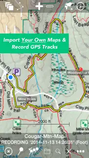
* IMPORT AND VIEW YOUR OWN MAPS and GPS tracks on your device, and record tracks and detailed WAYPOINT notes. MAPS n TRAX excels in rugged "off the grid" professional, academic, and recreational activity on land, sea or air!
* GREAT SUPPORT! MAPS n TRAX is well-supported with a detailed online User Guide (http://rallyto.com/maps-n-trax/maps-n-trax-user-guide/) and responsive, personal email support.
With MAPS n TRAX you can:
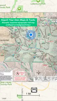
• Import and view your favorite maps (see supported file formats below*).
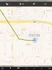
• View your current GPS location on your imported map.
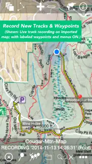
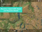
• Record GPS tracks.
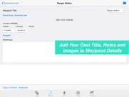
• Record waypoint details including photographs and field notes.
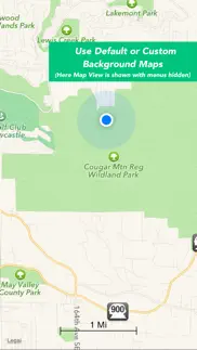
• View maps and tracks superimposed on familiar online background maps.
• Import GPS tracks from other sources or export your track records.
• Easily store, organize and access multiple maps and track files.
Use MAPS n TRAX to view specialized map files, topographic maps, or digital map image files and gps tracks on your iOS device. You can even import scanned paper maps or photos of maps!
Even when far beyond the reach of cellular data or WIFI networks, with MAPS n TRAX you can view your own downloaded maps and use the GPS navigational features of your iOS device.
MAPS n TRAX has numerous professional applications. Our customers use the app to support forest fire fighting operations; environmental and biological field research; search and rescue; petroleum and mining; real estate; geo-truthing; flying; sailing; and, academic research. The off-the-grid functionality and waypoint recording features provide a powerful mobile toolset.
MAPS n TRAX is also ideal for a wide range of outdoor recreational including: bushwalking, hiking, trekking, bird watching, treasure hunting, prospecting, camping, bicycle touring, hunting, fishing, snowmobiling, dogsledding, 4-wheel drive off-road motoring, geocaching, orienteering, randonneuring, mountain biking, skiing (downhill, backcountry, Nordic), and squatching, among others.
Many publicly available maps can be imported into MAPS n TRAX. In addition the app is well suited for applications that require specialist maps with details that are customized or are not widely available, such as highly detailed topographic maps obtained from your government mapping authority or specialized maps produced with GIS tools.
Details:
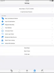
• Converts and displays a wide range of map and image file types including * PNG, JPEG, TIFF, GIFF, ESRI Shapefiles, ESRI File Geodatabase and Open Street Map (PBF & XML) and geo-referenced image formats such as GeoTIFF. (Note: .ozf2 & .ozfx3 files are NOT supported). See the User Guide for more information about working with these files.
• Imports and exports tracks in GPX and KML formats.
• Compatible with raster and vector map file types and projections used in commercial and open source Geographic Information Systems (GIS) software tools including ARCGIS and OpenStreetMaps.
• Automatically align geo-referenced image files or manually calibrate non-geo-referenced ones.
• Can display large maps and can join several consecutive large maps into a single huge map. The map size is limited only by the iPhone or iPad's storage capacity.
• Imported maps of different scales can be viewed simultaneously, adjacent to or overlapping each other.
• Multiple tracks can be displayed on maps simultaneously and tracks with named waypoints can be searched like a directory or gazetteer.
We recommend that you review our website www.rocketsplashgames.com/mapsntrax/support/ and the online User Guide to be sure that MAPS n TRAX suits your requirements. The User Guide section on Preparing Maps describes the process to prepare a plain image file for use as a location-calibrated and mobile-optimized map image.
Continued use of the GPS running in the background can dramatically reduce battery life on the iPhone or iPad.
😍 Do you love Maps n Trax - Offline Maps, GPS Tracks & Waypoints app? Please share your friends!

Please wait! Maps n Trax - Offline Maps, GPS Tracks & Waypoints app comments loading...
Maps n Trax - Offline Maps, GPS Tracks & Waypoints 6.2.16 Tips, Tricks, Cheats and Rules
What do you think of the Maps n Trax - Offline Maps, GPS Tracks & Waypoints app? Can you share your complaints, experiences, or thoughts about the application with Rocket Splash Games and other users?
Maps n Trax - Offline Maps, GPS Tracks & Waypoints 6.2.16 Apps Screenshots & Images
Maps n Trax - Offline Maps, GPS Tracks & Waypoints iphone, ipad, apple watch and apple tv screenshot images, pictures.
| Language | English |
| Price | $6.99 |
| Adult Rating | 4+ years and older |
| Current Version | 6.2.16 |
| Play Store | com.nixanz.Maps-n-Trax |
| Compatibility | iOS 8.0 or later |
Maps n Trax - Offline Maps, GPS Tracks & Waypoints (Versiyon 6.2.16) Install & Download
The application Maps n Trax - Offline Maps, GPS Tracks & Waypoints was published in the category Navigation on 02 November 2012, Friday and was developed by Rocket Splash Games [Developer ID: 471267937]. This program file size is 37.46 MB. This app has been rated by 1 users and has a rating of 1 out of 5. Maps n Trax - Offline Maps, GPS Tracks & Waypoints - Navigation app posted on 08 December 2016, Thursday current version is 6.2.16 and works well on iOS 8.0 and higher versions. Google Play ID: com.nixanz.Maps-n-Trax. Languages supported by the app:
EN Download & Install Now!| App Name | Score | Comments | Price |
| Temperature Log Book Reviews | 5 | 1 | Free |
| Outlaw TriPeaks Solitaire HD Reviews | 5 | 2 | $1.99 |
| Swipe Football Free Reviews | 5 | 1 | Free |
| Never Have I Ever Tap Roulette Reviews | 3.4 | 77 | Free |
| Ghosthunting Toolkit Reviews | 4.3 | 844 | $5.99 |
This app has been updated by Apple to display the Apple Watch app icon. -Updated help and support links and guides
| App Name | Released |
| EV Connect | 09 June 2017 |
| Neshan Map | 04 May 2023 |
| Find my Phone - Family Locator | 08 January 2013 |
| Footpath Route Planner | 07 May 2013 |
| Premium Parking | 22 October 2013 |
Find on this site the customer service details of Maps n Trax - Offline Maps, GPS Tracks & Waypoints. Besides contact details, the page also offers a brief overview of the digital toy company.
| App Name | Released |
| Sun Seeker - Tracker, Surveyor | 04 October 2009 |
| Tide Graph | 12 February 2019 |
| BLM Public Lands Map Guide USA | 27 December 2020 |
| Phoenix Zoo - ZooMap | 19 December 2021 |
| CDOT Colorado Road Conditions | 21 October 2020 |
Discover how specific cryptocurrencies work — and get a bit of each crypto to try out for yourself. Coinbase is the easiest place to buy and sell cryptocurrency. Sign up and get started today.
| App Name | Released |
| 09 October 2009 | |
| Google Chrome | 28 June 2012 |
| Telegram Messenger | 14 August 2013 |
| Ralph Lauren | 08 November 2021 |
| Google Maps | 12 December 2012 |
Looking for comprehensive training in Google Analytics 4? We've compiled the top paid and free GA4 courses available in 2024.
| App Name | Released |
| Incredibox | 27 March 2016 |
| AutoSleep Track Sleep on Watch | 19 December 2016 |
| The Wonder Weeks | 30 May 2012 |
| HotSchedules | 30 October 2008 |
| Bloons TD 5 | 15 November 2012 |
Each capsule is packed with pure, high-potency nootropic nutrients. No pointless additives. Just 100% natural brainpower. Third-party tested and validated by the Clean Label Project.
Adsterra is the most preferred ad network for those looking for an alternative to AdSense. Adsterra is the ideal choice for new sites with low daily traffic. In order to advertise on the site in Adsterra, like other ad networks, a certain traffic limit, domain age, etc. is required. There are no strict rules.
The easy, affordable way to create your professional portfolio website, store, blog & client galleries. No coding needed. Try free now.
Maps n Trax - Offline Maps, GPS Tracks & Waypoints Comments & Reviews 2024
We transfer money over €4 billion every month. We enable individual and business accounts to save 4 million Euros on bank transfer fees. Want to send free money abroad or transfer money abroad for free? Free international money transfer!
No Non-Sense Mapping app. It has a very simple interface, no more elements that are unnecessary, but it works as advertised. For users with a bit of knowledge this app is the best there is in the market. People who need this app already know what to do with it, for all others, a less advanced app may be in order. The author responds quickly to all inquiries.
Awesome!. This is a great app for people looking to get moving map capability from very specific maps. Offroading, low level flying, hiking, etc. This is the perfect mapping app for that. It does however require a bit of technical expertise when processing the maps to be readable by this app. But there is nothing out there that is as flexible as this. Vince
Save your money!. Downloaded this app to research some land i wanted to buy but later realized that the topography maps had to be downloaded... But wait there's more, it crashes as you try to insert the map and at the worst possible time!
Could be the greatest map app on the market. This app is one of the most promising navigation app on the market in my opinion. I love how easy it is to make new tracks and store them. Needs to fix a bug where maps ofset or move when alinged.
last version. last version crash when import .map please fix it
It's great when it works. This is a great app when it works. However I have had multiple issues with it crashing. At one point, it would crash whenever I would try to get it to display maps. After a installed the latest iOS, I could access my maps but now it kicks me off when I try to edit a new route or track. I have just uninstalled it and reinstalled and will see if that works. Annoying!
Awful. Crashes everytime you import a geotiff!
I want my money back.. I load in maps and calibrate them and they are more than a mile off. When you put the extents of a map it should land exactly where it belong. jpg maps can be seen fine but when I bring in a GEo PDF, it puts a worthless background in with the PDF and you can’t see the topo lines on the map and all of the text, which is all you can see, is so pixelated you can barely read it. Very disappointed.
very useful. Has some quirks, but by far the best ipad GIS program we have found so far. Allows direct upload of .shp files and georef'd rasters, plus export of wypts and tracks. We use it regularly during our field work. Good support.
Did you know that you can earn 25 USD from our site just by registering? Get $25 for free by joining Payoneer!
Maps n Trax. Works kperfectly. Great App
This is a fantastic navigation app. This works without a cellular connection. I have loaded all of the 1:250k Geoscience Australia map series, it is available free of charge on the net. I have loaded 1000s of KML waypoints from Google Earth. I have created tracks in Google Maps and recorded tracks around the Pacific in cruise ships using the world base map that comes in the app. I uses it on planes when flying across Australia to see where I am. It is an unbelievable app that is simple to use and highly recommended.
great.. Works great for what I need it for. I used it to import a map that I prepared using MAPC2MAPC app. Maps n Trax imported it like a dream. Haven’t tried other uses as yet. It’s good to have my own custom map installed on my device.
Works with Rooftop (jpg) maps. Took a punt on this as info was vague and not much supporting info on web. Developer "suggests" it might work with ozf or ozf2 files for calibration, but it does not. However, once you work out (via iTunes) how to upload the map jpg, calibration of the imported map was very easy. Basically just overlay your map with the inbuilt google maps (line up some tracks or dams etc) and click save and your done. I thought it works well as a locator - as in where was I on a bush track. Didn't use any other features.
Great app. I've found this app is great for viewing the .jpg map files I had on my PC. I found it easy to upload my maps and it has lots of nice features to organise and store the maps. Viewing the maps is also excellent with options to view-overlay multiple maps and also to have an online background map underneath. Recording tracks and creating waypoints is simple to use with lots of options. They also have an easy to read user guide at the website. Definitely worth purchasing for viewing your own maps.
Unhappy. Complete rubbish, most pathetic attempt at an offline mapping software I've ever used.does not import maps it claims it can.
App ok, support link broken. I've used this app since it's previous incarnation (Bitmap). It is fantastic for importing your own geo-referenced maps. Only complaint is that the support page listed in the description is no longer available.
It does not support Oziexplorer maps. I purchased it based on the advise it supports Oziexplorer ozf and ozf2 formats. As far as I can tell this is not true. I have tried ozf2 maps created in 2006 and even those it will not import. DO NOT BUY THIS APP IF YOU EXPECT IT TO LOAD OZI MAPS. It is a rip off.
Buggy. Upgraded form bitmap which was rock solid for me. Maps n Trax just crashes all over the place. Hopeless.
Promises lots, delivers little.. As others have said, does not import OziExplorer maps (even the really old ones) as the seller suggests. In-app calibration causes crash before calibration is completed. Have not managed to get even 1 map done. Authors suggestion to use bitmap s/w for cal also does not work. Pity.
Just ok. I’ve been using this app for a few years now. Its not too bad but there is what I believe a serious flaw. Occasionally, when you start the app it will not locate your GPS position. If you are within cellular coverage and turn your data on it will immediately locate your position. If you are outside cellular coverage, bad luck it will not show your position. The trick is to turn on the app while you are in cellular coverage and leave it on. I have reported the problem to the developers who did respond that they would look into it which of course they have not. Why would they, they already have my money. The same problem has occurred on an IPhone 5, 6 and 7. Its not the phone and all the other GPS apps I have work fine. Don’t rely on it if you are outside cellular data coverage.
Best apple raster map app. Best app for raster scanned maps, tools available to convert all maps to work on this app, best you can get for Apple
A great mapping tool. Ive found the Maps n Trax App to be a great mapping tool available at a very reasonable price. It allows users to interact with there own maps and user defined waypoints with great compatibility with both IOS and windows platforms. I highly recommend it and support the in-app developments that will give me greater operational mapping capabilities into the future.
iOS10 bug. The upper toolbar just appears as a white band in iOS 10, making it pot luck to try to select items. I reported this on 17 Sep 16, but have had no response as at 25 Sep
Does it all - but Opaque Toolbars?. What's with the new opaque black toolbars? I know you were having some issue with iOS 10 compatibility (opaque white top toolbar) but this is the wrong solution! Toolbars should not obscure the map. And it makes the translucent status bar (with map visible beneath) look a bit silly. Come on... fix it properly! Please. :-) This is the only app I could find that does both raster and vector maps as well as both online and offline maps, including custom online maps, not just the Apple or Google online maps.
Disappointed with latest version. As a longtime user of this otherwise excellent app, I am disappointed that the latest version constantly pressures you to create a user account and login. Why?
Not OziExplorer map compatible. I got this app because the blurb said it was compatible with OziExplorer maps. Well I have tried heaps of them (PC and CE versions) and not a single one will import with the calibration info. Very disappointed. It's a pity because the app looks good despite that although it has crashed out on me a few times.
It does not work in China. Coordination of waypoints are different from those from Builtin Compass app and Garmin GPS. Something Is wrong with the app. Hope it can be addressed soon.
Imagine you at your best. All the time. Picture yourself at your sharpest and most productive. Your most alert and focused. Your most lucid, creative and confident. At work. At play. In every area of your life. Add Mind Lab Pro® v4.0 to your daily routine and uncap your true potential. Buy Now!
Can't navigate to waypoints. Maps-n-Trax is useless for the function I need. I want to create waypoints in ArGIS, upload them to the iPhone and be able to navigate to them in the field. I can get the waypoints mapped but: 1) they appear and disappear erratically, 2) they don't function as waypoints (you have to drop a pin on them if you can find them) and 3) the "navigate to" function is primitive (indicates distance, and bearing but should switch to a clealry visible compass view).
Adsterra is the most preferred ad network for those looking for an alternative to AdSense. Adsterra is the ideal choice for new sites with low daily traffic. In order to advertise on the site in Adsterra, like other ad networks, a certain traffic limit, domain age, etc. is required. There are no strict rules. Sign up!