PRO CHARTS - Marine Navigation App Reviews
PRO CHARTS - Marine Navigation App Description & Overview
What is pro charts - marine navigation app? MiraTrex PRO CHARTS™ is a powerful, yet easy-to-use marine navigation system. Whether you’re a fisherman, weekend cruiser, sailor, diver, jet-skier, or an offshore captain needing to find an exact location hundreds of miles offshore, PRO CHARTS™ will get you there and back home safely – with nothing more than your iPhone or iPad.
Key Features:
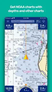
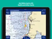
• High-resolution NOAA nautical chart coverage with depths for all U.S. coastal areas, the Great Lakes, major U.S. river systems, and Brazil plus global high-level nautical charts. Charts are automatically updated based on NOAA chart corrections.
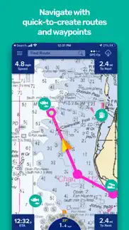
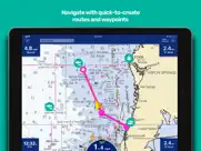
• Easy one-touch Waypoint and Route creation. Pre-plan your routes at home or create them at sea with equal ease. Just touch the screen to create new waypoints and routes.
• Find your friends on the water. With our new Buddy-tracking feature, you can see and meet up with your friends while you’re out on the water. If you’re on your secret spot and don’t want to be seen, you can hide your location with the touch of a button.
• Stay safe. Easily create and send a Float Plan of your trip to a friend or family member. Your Float Plan and location history can be forwarded to search and rescue personnel in case of an emergency.
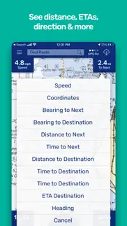
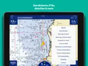
• Easy point-and-steer navigation. The red heading bug on the large on-screen compass always directs you to the next point on your route. Navigation is as easy as pointing your boat at the heading bug to stay on course.
• No Network. No Problem. PRO CHARTS™ is designed so no internet connection is required to view your charts while out on the water. You simply download in advance any charts you’ll need at sea with the touch of a button.
• Record your tracks. Track your position in real-time and later view your track history.
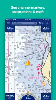
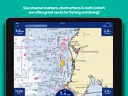
• Fully indexed point of interest (POI) database including weather, aids to navigation (markers and lights), obstructions, tides, currents, your buddies, and more.
Website: www.miratrex.com
--------------------
Plans:
Base app with limited features - Free
14 day trial of all premium features - Free
All premium features (Monthly) - $2.99
All premium features (Annual) - $29.99 (Save 16%, about 2 months free)
-Payment will be charged to your iTunes Account at confirmation of purchase.
-Your subscription automatically renews unless auto-renew is turned off at least 24 hours before the end of the current subscription period.
-You will be charged for renewal within 24 hours prior to the end of the current period, for the same duration and at the current subscription rate for that product.
-You can manage your subscriptions and turn off auto-renewal by going to your Account Settings in the Apple Settings app after purchase.
-No cancellation of the current subscription is allowed during active subscription period. This does not affect your statutory rights.
-Any unused portion of a free trial period, if offered, will be forfeited when you purchase a subscription.
-We will be collecting information about your use of the app both when you are online and offline. To find out more please see our privacy policy.
--------------------
By purchasing a subscription or downloading an app you agree that you have read and accept our Privacy Policy and Terms of Use.
http://www.miratrex.com/procharts/terms-of-use/
http://www.miratrex.com/procharts/privacy/
NOTE: Continued use of GPS running in the background can dramatically decrease battery life. Though PRO CHARTS™ will function without a GPS as a chart reader, a GPS-enabled device is required for point-to-point navigation. Third-party Bluetooth GPS units are available to enable GPS for iOS devices such as WiFi-only iPads that do not include a GPS receiver. For offline use where no Internet connection is available, charts must be pre-cached while still on-line and connected, any charts downloaded while online will be available for offline use.
😍 Do you love PRO CHARTS - Marine Navigation app? Please share your friends!

Please wait! PRO CHARTS - Marine Navigation app comments loading...
PRO CHARTS - Marine Navigation 5.70 Tips, Tricks, Cheats and Rules
What do you think of the PRO CHARTS - Marine Navigation app? Can you share your complaints, experiences, or thoughts about the application with MiraTrex, Inc. and other users?
PRO CHARTS - Marine Navigation 5.70 Apps Screenshots & Images
PRO CHARTS - Marine Navigation iphone, ipad, apple watch and apple tv screenshot images, pictures.
| Language | English |
| Price | Free |
| Adult Rating | 4+ years and older |
| Current Version | 5.70 |
| Play Store | com.derektrauger.simplecharts |
| Compatibility | iOS 14.0 or later |
PRO CHARTS - Marine Navigation (Versiyon 5.70) Install & Download
The application PRO CHARTS - Marine Navigation was published in the category Navigation on 04 August 2011, Thursday and was developed by MiraTrex, Inc. [Developer ID: 814855898]. This program file size is 45.02 MB. This app has been rated by 7,979 users and has a rating of 4.5 out of 5. PRO CHARTS - Marine Navigation - Navigation app posted on 01 November 2023, Wednesday current version is 5.70 and works well on iOS 14.0 and higher versions. Google Play ID: com.derektrauger.simplecharts. Languages supported by the app:
AR DA NL EN FI FR DE EL HE IT JA KO NB NN PL PT RU ZH ES SV ZH TR Download & Install Now!| App Name | Score | Comments | Price |
iOS 17 Bug Fixes
| App Name | Released |
| New York Subway MTA Map | 03 May 2010 |
| Google Maps | 12 December 2012 |
| EV Connect | 09 June 2017 |
| KakaoMap - Korea No.1 Map | 27 February 2009 |
| PlugShare | 07 March 2011 |
Find on this site the customer service details of PRO CHARTS - Marine Navigation. Besides contact details, the page also offers a brief overview of the digital toy company.
| App Name | Released |
| Cincinnati Zoo - ZooMap | 26 October 2021 |
| Blitzer.de PRO | 03 August 2022 |
| Trail Treker | 22 December 2016 |
| NavRules | 07 March 2011 |
| GoSkyWatch Planetarium | 31 January 2019 |
Discover how specific cryptocurrencies work — and get a bit of each crypto to try out for yourself. Coinbase is the easiest place to buy and sell cryptocurrency. Sign up and get started today.
| App Name | Released |
| ChatGPT | 18 May 2023 |
| 07 April 2016 | |
| DramaBox - Stream Drama Shorts | 18 April 2023 |
| Telegram Messenger | 14 August 2013 |
| Snapchat | 13 July 2011 |
Looking for comprehensive training in Google Analytics 4? We've compiled the top paid and free GA4 courses available in 2024.
| App Name | Released |
| Paprika Recipe Manager 3 | 15 November 2017 |
| Bloons TD 6 | 14 June 2018 |
| Geometry Dash | 13 August 2013 |
| Incredibox | 27 March 2016 |
| Poppy Playtime Chapter 1 | 08 March 2022 |
Each capsule is packed with pure, high-potency nootropic nutrients. No pointless additives. Just 100% natural brainpower. Third-party tested and validated by the Clean Label Project.
Adsterra is the most preferred ad network for those looking for an alternative to AdSense. Adsterra is the ideal choice for new sites with low daily traffic. In order to advertise on the site in Adsterra, like other ad networks, a certain traffic limit, domain age, etc. is required. There are no strict rules.
The easy, affordable way to create your professional portfolio website, store, blog & client galleries. No coding needed. Try free now.
PRO CHARTS - Marine Navigation Comments & Reviews 2024
We transfer money over €4 billion every month. We enable individual and business accounts to save 4 million Euros on bank transfer fees. Want to send free money abroad or transfer money abroad for free? Free international money transfer!
Stopped working the second day in open water!!. Stopped working the second day in open water!!
False information. Tells you two weeks free and that’s a lie you must have a plan with them to use that charts
Won’t work well enough to even try it once. Crashes or freezes when trying to set up an account. Can’t even get in.
Almost useless unless you want to subscribe. Now the price isn't terrible at $3/mo, but for somebody who only boats once or twice a month (have you seen gas prices these days?!) it's very hard to justify.
Doesn't work. App keep saying subscription expired and choose a plan. Same after subscribing and restoring purchases. Can't download charts. Use setting keep reseting chart to none. Save your money until it works.
Used to work great. I recently updated the app because it started bugging out after being a long time user with a great experience, but then I renewed my subscription and a “request timed out” window kept popping up after the recent update, so now I’m cancelling my subscription and never using the app again. Do not download this app. Recent updates have broken it.
Unable to open an account within the app.. Unable to open an account within the app. So the app can’t be use at all.
Ask Little Wayne. Doctor who Italian sweet creamer with raisins and pot put she likes it when I wear a soup need I say more
Cut me short on annual time. I purchased a years subscription. At 2 months left it stoped working. Scam. I will not recommend it again. If you pay for twelve months then you should get twelve months use.
Customer Service and gps erratic cancel subscription!!!. No cway in app to cancel. No response from customer service. GPS ERRATIC! Ship icon jumps around every 10 sec. or so, ans jumps cancel my subscription 1/2 to 1 mile. Not just a few feet. Still trying to get a refund. File complaint with iTunes where it is billed.
Does not work! Stolen Money!. Like many others. After the trial and paying for a years subscription, it suddenly stops working and you can not contact anyone with the company, due to network errors, time outs, etc. A complete fraud of a company just grabbing up peoples money. Can’t even figure out how to complain to them, or ask for a refund.
GPS spot on. The gps location on my boat is on the money. Thanks
Good potential, needs work. Using this app for the first time, I found it to be reasonably user friendly, but some features were difficult or impossible to use. I am writing this as a review because the “support” button does not work. 1) The boat icon’s direction is tied to the compass, not the actual track. As you move the phone, the icon turns. It is only correct when the phone is exactly aligned with the center line of the vessel. 2) Tried using the route feature with mixed success. Creating the route was straightforward, but when trying to edit or select a route, the list appeared to have a font of white on white. Same with other fields in the app such as editing a waypoint name. Finally had to give up on routes and use “navigate to point “ repeatedly. Used on an iPhone 8. This app has potential, but is not at the quality of a paid app yet.
Doesn’t show depths. I bought this app thinking it would be a way to navigate lakes but it’s no better than looking on google earth or OnX. There are no listed depths and topo lake maps are inconsistent at best.
Doesn’t work. As others have said you pay for the app and still asks for you to pay for it .
Quality issues. I really like the app but there is a major issue with the subscription. Even though my subscription is up to date, it continuously says I need to renew and the maps don't work. Very frustrating. I'm thinking of canceling my subscription.
Subscription not recognized. Paid for the monthly subscription but the app is not updating to reflect this. I am not able to use many features and I have to wasted time and money on this.
This app is worthless.. This app is worthless. It keeps telling me my subscription is expired when it’s not. I select the NOAA RNC or ENC chart and download it for the area I’m at, and it t displays for a second and then goes away and when you return to the chart page it’s has no chart selected.
Terrible experience. I tried. I really did. Made purchase and cannot use app. I tried to create an account and login to account inky to get time out error. I tried to restore purchase— nothing. When I try to use premium features, app error says I need premium subscription — which I have and have confirmation email saying I’m subscribed. and the circle continues. Going to have to bail. If they can’t get this right can I trust that it’ll get me from Long Island to Connecticut? Cant take the chance.
Too many problems. I tested several Mac apps and this one was the best... last year. This year too many problems and yes I am using the same phone. The icon is too big and does not point on your heading. Some areas of downloaded map are just blank. Very poor when zooming in or out.
Just a great app!. Been using this app for 8 yrs. I teach ASPS marine piloting and use this app for demonstration as well as navigation out on the big water. And tech support Is great!
Garbage app. No way you can rely on this app for navigation. The heading is not accurate. I am not able to download my charts in my area. I use it on Lake Tahoe and Monterey Bay and neither are available offline. I paid for the subscription and the app still reminds me to subscribe EVERY TIME I open the app, even if it’s already running in the background. Try a different nav app. That’s what I’m doing.
No free trial. App will not let you even see a chart without a subscription. Might as well just use Google Maps.
No support. I have been trying to download charts for a few days. I am trying to download the St Lawrence River. I have repeatedly tried to do this download but it does not give me the complete down load. Even befor the download the chart is incomplete. Support button does NOT work.
Bait and switch. Downloaded it and really liked it. Spend hours getting familiar and uploading my coordinates. Logged in today to see that they removed the chart overlays unless I start paying a subscription. This is a really crappy thing to do. So much of my time wasted.
Very Useful. Great app - I use it every time I’m on the water!
Wish it had variation depths charted. Would be a lot better if there were depths charted on the map similar to navionics As a charter guide I’d love to use these maps but I need to have the depth variations so I can judge whether to run to different depths or stay put. I absolutely love this app but sadly because of the depth issue it’s hard for me to continue.
Never worked, took my money. The trial version worked perfectly and the app was pretty solid. Upon paying for my yearly subscription the app would constantly mention that my trial subscription was over and that I had to purchase a subscription even though I had already done so. I ended up purchasing the Boating app which worked perfectly from the start.
Great tool to use while sailing. I downloaded the app prior to our first coastal cruising venture on our Catalina 22 sailboat. I found it much easier to read than our handheld Garmin unit. I’m still learning how to use all of the features and plan on visiting the full website for full instructions on how to use all of the features.
Best app.. Best. I use this over my gps and radar electronics on boat
Not Intuitive. All I want is to download an area, and have my depth contours and hazards mapped. All I can see is Google Maps type images, and can not find how to get bathymetry. Can't anyone make something as useful as the old Navionics?
Wish it worked. Downloaded a used the two week free trial. I liked it for the most part. Once the trial was over I subscribed to continue using. It failed to work and kept trying to sell the subscription (I had paid for a year through iTunes). I tried logging out and logging back in and received network errors and time outs. iPad turned off and on, still failed to login. Sent a message to support and haven’t received an answer. Deleted and canceled membership. Potential is lost.
👎. Terrible app…inconsistent charting, chart disappears randomly if it overlays at all. Tried it for two weeks then cancelled my subscription. Don’t waste your money.
Can’t use. I created an account after paying for a full year, when I sign in I get a window that says “can’t connect to the server” At the same time all my other apps are working okay.
I have to restore purchase every time I open the app. Once you restore the purchase it works until you close the app. Then everything goes back to square one. I downloaded maps and then it was gone too. I can’t truly rate this with a high rating until I can get it to work properly. Please fix it! Thanks.
Card charges. Please don’t charge my account twice for this service. I’m on auto renew and my credit was shut off. It’s now back on. Please don’t bill me twice. Thanks
They should tell you the cost before you have in input your information. Disappointed as you are automatically enrolled for monthly fee
Does not work right. I have paid for several months and the app keeps asking me to become a subscriber. The charts download and then disappear. This has been useless to me. I have it on a 13 Pro. Support said to click retrieve purchase, that fixes nothing. I think somebody owes me some money back.
Subscription. Like all these other useless apps,once loaded on your device they ask for money to make it function.
Horrible. I purchased and was charged and still have not been given the premium. I’m sent emails and still have gotten no response.
Could not figure out how to get to a chart. App seems buggy. I’m a professional software developer and couldn’t figure out how to look at a chart at all - the view kept going back to satellite view. I ended up paying for another app instead.
Fozen. Decent but often freezes and every time I try to contact support I never receive a response
Doesn’t matter how good it might be - support is virtually nonexistent. Why sell an app and put out the illusion that you are in business when it takes you weeks to reply to simple questions, if you bother to reply at all? I had hundreds of waypoints to import that were converted by GPS Visualizer to 8 digits for the fractions after the period - the instructions for this app show 6 digits. Do I need to round or truncate the 8 digits? Can you import tracks? None of which matter now as I cancelled and deleted the app. What an inconsiderate time waster.
Locked. Must have forgotten password and there is no way to get it reset. So this app is locked for me. Silly, what is so valuable in there?
Can’t cancel subscription. Canceling your subscription is virtually impossible. I’ve contacted the company twice. Tried to cancel before the free trail period was up. Nope. Their directions do not make sense. I can’t figure it out. So I guess I’m paying 2.99 a month until I get help. They got me!!
Glitches galore. I’ve had this app for 16 months and have kept it on my IPad as a backup to Navionics on my chartplotter. It’s in a nutshell just a GPS overlay on NOAA charts. You have to select the areas on the map that you would like to download, and even after downloading the screen will go half blank randomly while underway. Most chart downloads are dated info, and zooming in for detail the chart generally just disappears, leaving you to find the bottom with your keel. For all intensive purposes I guess it’s ok as a backup, but nothing compared to Navionics, and cannot safely rely on it for navigation. If your looking for an accurate, up to date, and reliable product, this isn’t it.
Can’t create an account. First page will not let me create an account. Says “invalid login”. I want to like this app but so far it’s just irritated me.
You better remember your login. I only use this in the summer. so after a summer of hard fishing and a lot of stored data it’s gone the next year because I forgot my login credentials and there is absolutely no customer support glad I wasted 4 buck a month for nothing
Great app. Easy to use. Great value for the money
Do not purchase. I was on the lake. Needed to renew subscription. Did so. Got confirmation from Apple. Application said all set. Tried to use chart overlay. App says I need a subscription. I’m on the lake you dumbbells. I need this to work. You lost me as a customer. Cancelling. You stink! Want to contact me? Sorry, maybe you need a better way of contacting you. Pfffft. On to the next thing.
Did you know that you can earn 25 USD from our site just by registering? Get $25 for free by joining Payoneer!
Don't waste your time. No sooner I had downloaded this and was asked to create an account after that it automatically said my time was expired and asked me for money...run in the opposite direction....they should tell you all this before hand, Very sneaky.
Not for outside USA. I subscribed and now find that there are not nautical charts for Australia. This should be more obvious beforehand. So it is not suitable for navigating the indian ocean.
No charts for Australia and cannot delete auto renewal. There are no charts for Australia which should have been made obvious at time of subscription. The instructions on how to delete the auto renewal subscription don’t work! Help support do not respond to requests to delete the auto renewal.
Imagine you at your best. All the time. Picture yourself at your sharpest and most productive. Your most alert and focused. Your most lucid, creative and confident. At work. At play. In every area of your life. Add Mind Lab Pro® v4.0 to your daily routine and uncap your true potential. Buy Now!
Trial not working. Charts are not showing
No support?? . . .. Sooo, tried Help/user manual .. Returns to prev screen with no manual .. Tried Help/customersupport .. App crashes to main screen I paid for a damn subscription, so i expect to be able to know how to USE the damn thing .. Fix, or i expect my money returned Update .. Even the damn support link on the app page doesnt work .. Seriously?
Major problems for me.... Paid for subscription but have to renew purchases every time I open the app. Cannot download charts. Info window blocks 90% of the screen and it’s “dismiss” button won’t remove it. Help link doesn’t work. Email to co unanswered. Shame, sounded so good but useless to me. I recommend you not to waste your money. Seems I have unless they surprise me and get back time with fixes for all these
Difficult to use. No instructions on use, difficult to navigate, no option to plot a course. Pretty useless, save your $.
Adsterra is the most preferred ad network for those looking for an alternative to AdSense. Adsterra is the ideal choice for new sites with low daily traffic. In order to advertise on the site in Adsterra, like other ad networks, a certain traffic limit, domain age, etc. is required. There are no strict rules. Sign up!
Not for Lake Tahoe. Did not find us at Lake Tahoe
Not happy. Took my money and did not renew my subscription.
Great app. I have experimented with a lot of marine apps and this one is my favorite by far. The only thing that I didn't like was that it would not follow your movement keeping you centered on the screen. But after some very helpful communication with the developers, they explained why it didn't do what I wanted, but also assured me that this functionality would be included in the next update or two. They delivered on their promise and I have a great app that I use every time I am on the great lakes. I can also export all of my waypoints at once, in the form of an email, to my iPad and BAM, everything is there too!
requires acc, no topo feature. spent 10 mins trying to view topo.. now to deal with spam mails 1 star
big features + low cost = great app. This great little app does it all. The charts are great and a pleasure to look at. The controls within the app are laid out well making it very easy to use. I especially like the bar that collapses moving the controls off the screen to give you more screen real estate when you don't need them, a very nice touch. Adding waypoints to navigate is done in a breeze by just tapping and hold the spot you want to add, it instantly gives you feedback about that waypoint (how far away, how long till I get there, etc.) and you can easily see and track your progress towards that point. The position accuracy is spot on and shows exactly where I am, if I ever where to get lost (not likely) it would definitely get me home. Overall the app is packed with a ton great features, at its core it is simple and easy to use, it looks great on both my iPad and iPhone (another great feature, you buy it once and you get to use it on both your iPhone and iPad without being charged for a second copy), its accurate, and at the end of the day it just works for me. Thanks for a great app.
This is crap.. This app does not work. When I’m on the water it says I’m on land.
Fishing. God
Good app. Amazing app. Very detailed
Nope. Very disappointing. Tried to pull up this app on another device while navigating unfamiliar waters. Nothing was saved
Fishing. Thanks
great no hassle simple charting app. This thing is perfect for fishing and cruising it is stupid simple to pick up and figure out how to use. From the start it was able to accurately plot my location on the chart, I was able to clearly see the NOAA charts for my area (south Florida), I was able to easily add waypoints to the chart for where I wanted to be. I noticed that the speed and location seemed to be right on and the apps calculation of when it thought I would arrive at my next location was relatively accurate and seemed to update itself as I changed speed or course. I used the app over the past weekend strictly on my iPhone and decide to purchase for my iPad and was pleasantly surprised to find out that I would not be charged for the second copy which made the purchase well worth it as I essentially paid $5 per device. Other top notch features I found particularly interesting was the ability to adjust how transparent the NOAA charts were so you could get where all you could see was the NOAA chart or add in the satellite imagery in the background just visible enough to add a great deal of detail. The topographical maps are not the best but I can't penalize them for it as it is a marine charting app but if they added higher detail topo charts the app would be highly useful as a hiking app as well. This app is well worth the price.
Easy to use. I recommend this App! I used to use it a few years ago and came back to it because it's easy to use compared to some of the "top grossing" apps that I paid for. Personally, I don't know Captain terminology so a lot of the extra info available on the other apps was convoluting my screen. Plus, I was paying more for info that wasn't serving my needs. I just need an easy to use app that provides the NOAA charts layered in with my GPS location which shows the depths with contour lines and where the obstructions are so that I can avoid the wrecks and sand bars. This app provides this for me and I'm very satisfied! It does provide more than I've mentioned here but I won't go into those details. Happy and safe boating to you⚓️
Rick Martin USN CDR RET. Great operational and intuitively obvious App.
Not happy. Takes money. can’t log in or reset password. No support. I’m out
Terrible. Downloaded app...couldn’t even get it to register
Simple charts review. Very impressed with the app. We have taken it along on a handful of trips down the ICW from southern VA to Key Largo. The instruments panel including location, speed, distance, etc has matched my garmin installed onboard in every instance that they were side by side. Love the detail in the raster charts rather than the electronic charts on the garmin much more appealing to look at. My wife and I really enjoyed the course export functionality that allowed us to share our course with friends which has come in handy. Really like the app and have already gotten more than $10 worth of enjoyment out of it. Hopefully the developers will continue to add new features. We requested several features which we would find useful and think others on the water would as well. They stated that they would be adding these features to a list of enhancements they have planned so time will tell if they get added.
Not working. Screen unresponsive
No text. I downloaded the app and I’m assuming it’s trying to get me to buy the subscription but there’s absolutely zero text above the “learn more” and “dismiss”
No way to cancel. Save your money and get Navionics. This app is useless, and better yet, there is no way to cancel the automatic renewal. Theft by deception!
Can’t create account. Literally can’t even get into the app let alone make an account
Simple Charts - GREAT APP!. I am using the app with my IPad 2 with the Dual GPS receiver and it works great. The best thing is the support from the developer. Send a email and you get a very fast response. All the maps load up quickly and you do not need a wifi connection after you look at the maps and zoom levels which you desire, they are cache. It is very easy to use and allows for another use of your IPad or other device with the added expense of buying a plotter. I had to buy the Dual GPS device because my IPad is wifi only. The developer does not charge extra to have it loaded on my IPhone. Should be more developers like this providing apps of all type.
🤬😡 I downloaded by accident and now I can’t find a was not to get charged for this app anywhere. I I
FIX YOUR APP!. Frozen .. can't log into app .. no way to cancel .. stealing people's money!
Good. very good
Fees. This app is not free — $30/yr.
No quality maps for Minneapolis. High quality depth mapping of the lakes around me is not a part of this app for my area in Minneapolis/St Paul area
Free Weeks. No email sent for my two free weeks.
No depth chart. None
Best app combining satellite photos with charts. For the last three years I've gone up and down the ICW from NY to Key West and I've found this app invaluable. It starts with a chart view of an area and as you magnify the image, it changes to a satellite view. This is very useful for several reasons: - You can see the layout of a marina before entering from the satellite view so getting directions to your slip is less confusing, especially for very large marinas. - We have a dog on board so we'll look at an anchorage and see if there is a sandy area for dog relief. - Shallow areas show up lighter in color so we can see where shoaling is occurring before running through a shoaled area on the ICW. All of the above is possible with Google Earth but this app is much more convenient to use since it starts out with the familiar charts first and this app places the markers and buoys symbols right on the satellite view, Google Earth doesn't. It works well with a bluetooth GPS to show your position on the charts and satellite view as you move along.
Very poor. Subscription fees are debited like clockwork but the app fails to allow access to charts. Waste of money and frustration on the water. Buy a handheld map!!!
This app blows. Charts never seem to load
Charts. With 37 yrs. in the maritime industry I've used all the plotters and gadgets. For 10 bucks it's worth it. Only issues so far are that some areas in the NE will not load a few tiles. You either get the google earth tile, a fuzzy tile or a grey tile. Not sure if it's a local thing for certain charts and have yet tried to cache charts in the Gulf of Mexico and the SE. Hopefully they will be able to get this bug out. Other than that it works well. Would like to see them interface AIS with the system. Such as Marine Traffic. It would also be nice to add ETA's as well as COG and Heading vectors on your position. I'd pay more if it was incorporated into the system. Otherwise, for 10 bucks it's a deal. Hopefully they can clean up the tile issue.
Captain Larry. Best app ever. Thank you
Best $10 I ever spent.. I would like to thank the developer of this app for his responsiveness. Every time I write a note regarding a problem with this program, I get a response from the developer. I have used this app in the St. Lawrence seaway (Thousand Islands), okeechobee canal in Florida (weak detail in the canal compared to the on board chart plotter and paper charts) and my home waters (CT shore) with satisfactory results. When I come across an area where the charts are not reading correctly, I inform the developer. I gave them a wish list for future development, and so far I got landscape functionality. I'm hoping to see the chart follow the boat soon so I don't have to keep centering it. I recommend it to anyone with an iPad and a boat. Keep up the good work with the functionality improvements. By the way fellow boaters, you can put your iPad in a ziplock bag to protect it from water spray and it still senses your touch.
Cannot download marine charts. Purchased the app, but the app will not permit any nautical charts to be downloaded. There is no table of definitions or a instruction set that I could find. The help/support function email that I appealed to yields no response. I was very disappointed. Kevin Leary
Charts don’t work. Click a chart type download it and it just shuts off. Not worth it glad there was a free trial junk
Pointing us in the WRONG Direction. 1st time boat owner — lost on 10,000 acre lake, low on gas and this frickin’ app is sending ya in the wrong direction—don’t bother!
Worst App. Stay away, you’re on your own with no way to talk to anyone.
Doesn’t work worth a crap. Chart shows up for 1 sec then disappears. What a piece of crap app!!!
Unstable. App is unstable. Will not launch.
simple charting app review.... Over the past few months I have tinkered with several charting apps available ranging from free to upwards of $30 and I have come to the conclusion that simple charts is by far the easiest to use and most complete app available. The app is the perfect compliment to my onboard system and functions smoothly as I go in and out of cellular or Internet service. As the name indicates is fairly easy to operate and the learning curve is low as I compare it to most of the others. The feature set is much more than I anticipated and caters very well to my needs. The documentation is on the light side but I found the FAQ section useful, the support email allowed me to contact the developers and get the remaining questions I had answered. I was pleasantly surprise at the quick turnaround on the email and the tone and level of detail provided led me to believe they actually cared. highly recommended.
This app is CRAP!!!!!!. Don’t waste your money! This app can not be relied upon when really needed and the developers off NO tech support. Totally a waste of money!!!!
Frozen 😝. Frozen screen when we needed it and very difficult to cancel . Super frustrating
Terrible App. Navigates in straight lines across land and no way to cancel! I will contact Apple to get my money back. How is there seriously no way to cancel??!!!!
Plotting. Creating a route is challenging and not intuitive.
DG13!!. Cant figure out how to make a auto route
Wow. Could not for the life of me figure out how to apply a chart overlay. Not user friendly.
Fail. Horrible app that gives no useful information. Do not Buy!!!
Chart overlays. Cannot get the chart overlays to display.
Half hour to sign in???? This is not good.. Bad 1/2 hour to use app