GPS & Map Toolbox App Reviews
GPS & Map Toolbox App Description & Overview
What is gps & map toolbox app? ◦ This is the ultimate GPS location database tool designed to save, organize, share, display, import, export, and analyze location records and their properties.
◦ Extensive customization options make this app useful for everyone from salesmen, hikers, farmers, hunters, scientists, land/site surveyors, search & rescue, police, and military.
◦ The features are organized into levels so you only need to buy what you need. The basic features are available in the core app. The other feature levels can be added through an in-app purchase.
▼ BASIC Features (built into the core app) ▼
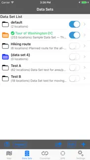
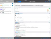
•Organize location data into Data Sets and basic Groups.
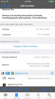
•View and convert between coordinate formats (Degrees Decimal, Degree/Minutes, and Degrees/Minutes/Seconds).
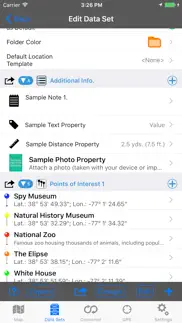
•Custom text and note properties.
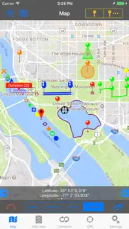
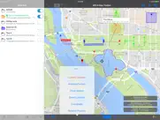
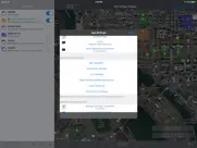
•Display a single map overlay for each location.
•Raw GPS data.
•Share data with other devices running this app.
•Send locations to third-party apps for mapping and navigation.
•Extensive in-app help screens explain all features and options.
▼ PROFESSIONAL Features (available through an in-app purchase) ▼
•Group locations into Areas, Track/Paths, and Routes.
-Display groups on the map with customizable lines and fills.
-Perform calculations on groups.
•Additional coordinate formats: UTM (Standard and Extended), USNG, and MGRS.
•Display Secondary coordinate.
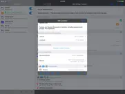
•Custom properties such as numbers (with and without units) along with automatic data detection.
•Export data sets to third-party apps.
•Additional map marker style options.
•Export file types: GPX, KML/KMZ, CSV (comma separated values), TXT (tab delimited values).
•Business Search.
•Full-screen map screenshots.
▼ ADVANCED Features (available through an in-app purchase) ▼
•Attach photos to data sets and locations.
•Additional coordinate formats: British National Grid, and Dutch National Grid.
•Location templates allow you to specify custom properties that are automatically created with every new location.
•import file types: GPX, KML/KMZ, CSV (comma separated values), TXT (tab delimited values).
•View location data from multiple data sets simultaneously.
•Multiple map overlays per location with additional types.
•Text based Routing (bearing and direction between points in route).
▼ Extra Data Sources (available through an in-app purchase) ▼
•Use non-Apple data sources (Google and OpenStreetMaps) for map data. This includes map view, elevation, geocoding, business/place search, and street view.
😍 Do you love GPS & Map Toolbox app? Please share your friends!

Please wait! GPS & Map Toolbox app comments loading...
GPS & Map Toolbox 3.0.2 Tips, Tricks, Cheats and Rules
What do you think of the GPS & Map Toolbox app? Can you share your complaints, experiences, or thoughts about the application with Audama Software, Inc. and other users?
GPS & Map Toolbox 3.0.2 Apps Screenshots & Images
GPS & Map Toolbox iphone, ipad, apple watch and apple tv screenshot images, pictures.
| Language | English |
| Price | $1.99 |
| Adult Rating | 4+ years and older |
| Current Version | 3.0.2 |
| Play Store | com.audama.gmtoolbox |
| Compatibility | iOS 8.0 or later |
GPS & Map Toolbox (Versiyon 3.0.2) Install & Download
The application GPS & Map Toolbox was published in the category Navigation on 31 May 2011, Tuesday and was developed by Audama Software, Inc. [Developer ID: 344990613]. This program file size is 27.03 MB. This app has been rated by 13 users and has a rating of 3.3 out of 5. GPS & Map Toolbox - Navigation app posted on 28 September 2017, Thursday current version is 3.0.2 and works well on iOS 8.0 and higher versions. Google Play ID: com.audama.gmtoolbox. Languages supported by the app:
EN Download & Install Now!| App Name | Score | Comments | Price |
| Word Unscrambler Reviews | 3.1 | 23 | $1.99 |
| Word Blender Reviews | 4 | 2 | $0.99 |
This app has been updated by Apple to display the Apple Watch app icon. 3.0.2: Bug fixes and minor performance improvements. 3.0.0: This is a major update that incorporates many of the frequently requested features. Continued feedback and suggestions are always appreciated. The new features include: •Updated for iOS 11 and 64-bit. (Requires at least iOS 8). •Renamed “Log File” to “Data Set”. •Data can be organized into different types of groups (Properties, Location Lists, Areas, Track/Path, Route). •Area, Track/Path, and Route groups are displayed on the map with customizable lines and fills. •Attach photos to a Data Set or Location. •Create custom properties in Data Set records. •Create custom properties of various text and number types (with or without units). New property types include notes, number/distance/area/angle/time/speed units, boolean, date/time, and URL. •Property values can auto-detect email addresses, URLs, and phone numbers so the appropriate actions can be performed on the data. •Define Location Templates which automatically create custom properties in newly created locations. •Perform calculations on groups of locations (such as area, path length, etc.). •New import options: GPX, KML/KMZ, CSV (comma separated values), TXT (tab delimited values), and Excel (supported through the CSV/TXT import feature). •Additional customization options when exporting data. •Export data to other third-party apps including cloud drive apps. •Import and export coordinates through the clipboard. •Additional map data sources (Google and OpenStreetMaps) for features such as: Map view, elevation, street view, geocoding, and place/business search. •Removed Bing Maps data source (This version is no longer supported by Microsoft). •Additional coordinate formats: UTM (Extended), British National Grid, and Dutch National Grid. •Additional distance units: Nautical Miles, Yards. •Additional location map overlay style and color options. •Move/Copy individual location records to other Data Sets. •Sorting data based one of several parameters. •Many additional map marker sizes and styles (Drop pins, various shapes, text labels). •Improved GPS performance. •Easily take map screenshots. •Hide Data Set list pane on iPad while in landscape orientation. •View location data from multiple data sets simultaneously. •Address data can be inputted into formatted fields. •Detailed help screens throughout the app as well as an F.A.Q. •Lots of additional display/feature customization options. *Some features require the purchase of an in-app upgrade.
| App Name | Released |
| Electrify America | 03 June 2019 |
| Speedometer Simple | 18 November 2014 |
| Footpath Route Planner | 07 May 2013 |
| OnX Backcountry Trail Maps GPS | 09 December 2020 |
| Find My Friends Phone - iMapp | 26 July 2014 |
Find on this site the customer service details of GPS & Map Toolbox. Besides contact details, the page also offers a brief overview of the digital toy company.
| App Name | Released |
| Holding Pattern Trainer | 16 August 2011 |
| Speedometer Speed Box | 11 February 2019 |
| Sun Seeker - Tracker, Surveyor | 04 October 2009 |
| Light Pollution Map | 20 September 2020 |
| WakeWatch | 31 March 2016 |
Discover how specific cryptocurrencies work — and get a bit of each crypto to try out for yourself. Coinbase is the easiest place to buy and sell cryptocurrency. Sign up and get started today.
| App Name | Released |
| 07 April 2016 | |
| Telegram Messenger | 14 August 2013 |
| 05 February 2019 | |
| TikTok | 02 April 2014 |
| SHEIN - Online Fashion | 19 May 2014 |
Looking for comprehensive training in Google Analytics 4? We've compiled the top paid and free GA4 courses available in 2024.
| App Name | Released |
| Monash FODMAP Diet | 17 December 2012 |
| Plague Inc. | 25 May 2012 |
| TV Cast Pro for LG webOS | 23 June 2016 |
| Poppy Playtime Chapter 1 | 08 March 2022 |
| Procreate Pocket | 17 December 2014 |
Each capsule is packed with pure, high-potency nootropic nutrients. No pointless additives. Just 100% natural brainpower. Third-party tested and validated by the Clean Label Project.
Adsterra is the most preferred ad network for those looking for an alternative to AdSense. Adsterra is the ideal choice for new sites with low daily traffic. In order to advertise on the site in Adsterra, like other ad networks, a certain traffic limit, domain age, etc. is required. There are no strict rules.
The easy, affordable way to create your professional portfolio website, store, blog & client galleries. No coding needed. Try free now.
GPS & Map Toolbox Comments & Reviews 2024
We transfer money over €4 billion every month. We enable individual and business accounts to save 4 million Euros on bank transfer fees. Want to send free money abroad or transfer money abroad for free? Free international money transfer!
Really Excellent. Refers to an IAP, but purchase option not found in app or in AppStore description. Presumably that's coming. Everything I want is there; I just needed to get familiar with the app. A little clicking on the various features and I was good to go. I'm very pleased with it and recommend it to anyone who just wants to do some casual location mapping without taking a course in GIS.
What happened?. So I paid for this app last year it worked great. You made me update it and now I have to pay a ton of money for a working app now? This is not cool I can’t even share my files now.
Extremely useful. I live by this app. Find your spot and drop a pin, input title, description and additional information as needed. Export to other devices on different formats. I don really use the conversion tools, but for remembering particular areas, spots or limits it is great.
Does not import KML files. I bought this app because I thought it would allowed me to import KML files that I created using google maps. This app will only export KML files.
Bookmarks for Offline Use. Need user-friendly way to create KMZ files to use in the offline app MAPS.ME. This is necessary because if its limited search capability. Need the offline app feature because I’ll be traveling in EU with no data service on my iPhone. In this way, GPS Toolbox serves as an excellent trip planning tool. Works great now that I figured out the user instructions are located in “Settings/Help” 5 star SUGGESTION: provide a link to a downloadable pdf file for HELP information ~ perhaps you could call it USER MANUAL :)
Works great. Solid app that does it's job. I use it to document site locations like utility poles. It also allows to send to the app on other devices. Export to Google Earth works well.
Like Nike- Just Do It. Great app..HIGHLY recommend..used for land navigation and found points quickly and accurately...
Very useful, too bad it locks up. Perfect for my use, determining a 200 foot radius circle around structures for brush clearance (fire insurance requirement). Put a pin on the structure, set the radius, then walk around the edge of the circle staking it out. I'd give it 5 stars but it has locked up a few times in the couple of days I've been using it. That's a nuisance, but the app still gets the job done.
This app saved my bacon last night. My topo programs won't overlay google maps and google earth doesn't seem to let you even drop a point! This app does both and is a valuable connector for exporting, converting, or deciding on coordinates! Our 15 person trip was saved by buying this app in a last ditch effort.
Best mapping app. I'm a professional motor coach operator. I drive a lot of elite passengers such as college and professional sports and members of congress. This is my primary mapping and trip planning app. The satellite view allows me to see my target destination so I know whether a 50 foot bus will fit. Data logs allow me to store places I have been for future reference. I have over 300 stadiums and arenas stored for instant recall. For mapping and trip planning I haven't found a better or more functionally comprehensive app.
Works Great. Highly recommend to anyone needing to create and work with .gpx and .kml files among others. Only one suggestion so far. Ability to import .gpx and .kml files, which the developer is currantly working on. Thanks for a great app.
Gis. It does what it says. Works pretty good. Some minor tweaks and 5 stars.
Phenomenal. Combines many of the various functionalities of Google Earth and Google Maps, smoothly and seamlessly. I effectively replaced my Garmin, lost hiking in the woods, with this app. Not only have I not regretted this decision, I'm actually happier with this app than I was with my $200 GPS device. It simply does everything I need it to and more. Great being able to enter detailed descriptions of all waypoints, too, rather than being limited to six characters. Even better, two of the three issues I had with it were fixed with the last update. Fantastic.
Updates are expensive. I got this app almost 5 years ago for a small price and it was an absolutely wonderful app to use. It provided almost every type of navigational means to get you from point A to point B and plan a good route. IT WAS PERFECT. However, they made an update where you had to pay 15 dollars just to keep your right to continue to do the same thing you have been doing for 5 years. I thought "hey I really need this app for work and it's only 15 dollars" so I bought the update for 15 dollars. not a single month later they do the same exact thing and now say I have to pay 30 dollars to be able to use this app! They have become money grubbing people!!! DO NOT USE THIS APP. They are taking advantage of all the people who have become dependent on this app. Don't support these inconsiderate bullies. Thanks for taking this into consideration before buying this app.
Awesome!!. Love the app & what it does. I just wish it could work with the GPS satellites rather than from cell phone towers to know your location. Most of the places we go has poor or no cell phone reception.
Need External GPS link. Would like to use Garmin GLO or other Bluetooth gps to use within app.
GPS Toolbox. I Just Got Couple Days Ago Still Figuring All That It Does But So Far Very Happy I Work in Waterworks And Do LineSpots For My Company, It Works Well And Is Pretty Precise I Pitted It Against A Garmin GPS Handheld And GPS Toolbox Performed Better Than I Figured For $2.99 Worth Every Penny!!
Unfortunate. This app, when working, is absolutely a 5 star one. However, right now it locks up, won't save and is a big disappointment. Why would someone put in all the work and then not keep it updated?
Not user friendly!. Wanted something simple and easy for quick driving directions and this is NOT it!!! Would get my money back if I could.
Land nav / coordinate generation. Great App, I've only briefly started using it. But at first glance it does everything I was looking for: convert coordinate formats, distance & bearing, set waypoints with descriptions. Things I'd like to see in future versions: ability to choose between magnetic north and true north for bearing calculations (and display them as a map feature even if working on another item), more distance and coordinate systems, ability to display multiple distance formats at the same time (i.e. Elevation in feet and meters), and lastly the ability to hard set distances (i.e. I only want to see distance in nautical miles even if measurement is less than 1 nm, or meters even if greater than 1km). Overall great program I look forward to future updates. Highly recommended!!
Just What I was looking for - Thanks. I was looking for an app that allowed me to place inspection points on a map around structures. On Day One - This app allowed me to do everything I wanted and tagged the points with GPS within a few feet. Can't wait to see what I can do once I learn how to use it.
Be Warned. The ap only understands UTMs in NAD83. Just about every USGS map you might find will be in the NAD27 datum. This critical limitation prevents using the ap to support my real world Search and Rescue missions; you can't ever exchange data with anyone else.
Awesome. I work for a Fire Rescue department, and use this app to log hydrant and building locations within my jurisdiction. It is an amazing tool, allowing myself and crews to make critical response decisions en route to calls. It also utilizes USNG for land navigation as an option, which is the nav system we use. The app allows me to quickly see the building I am going to, the nearest hydrants, satellite view of terrain and objects, utility shutoff points, and with the touch of a button go to google maps for turn by turn driving navigation. It also has a built-in conversion button for converting USNG to degrees/min/sec for giving aircraft landing coordinates. Amazing.
Garbage - don't buy. Does little. Thought it could import Google map data - nope. Useless program.
Very inaccurate. Elevation numbers are very inaccurate . Locked up all day trying to locate elevation changes for irrigation project in SC. At Daytona Beach FL now and did a current location check . Showed elevation of 87ft. I'm 5 ft above sea level!!!!
Awesome. This app is totally awesome ok so the coordinate are excessively accurate but hay who’s gonna complain about that
Hmm..... Does nothing for me. Bought it accidently and was a huge blunder.
Excellent, But..... I got this app right after it came out, and have loved it ever since. But....! Why can't the satellite maps be updated? I have new facilities in my fire response area that aren't on the maps, but are on other mapping programs. I have Blue Pins designating structures, that are sitting in the middle of large grassy fields. If at all possible, please update the maps! Thank you!!!
Great app for LEOs. This a great app for Law Enforcement. I use this guy instead of our department's PC app on our Toughbooks because it is so much easier to use. Though i havnt figure out how to measure distances for pursuits. I only can measure straight line "as the crow flies" distances. I always use this app for getting lat and lon for incident location, traffic stops, collision reports, and referencing the lat and lon to plug in to my gps for navigation. I use the data logs to set up quick reference or hot spots for later use so i dont have to search for the address. I do admit it was a little confusing at first without looking through a turtorial and Im sure there are other capabilities i havent figured out yet but it is a great app so far. Ive highly recommended throughout my department.
Good app start. It crashes when you switch map sources. Also the Bing maps are locked so you can not change you viewing direction..view from N or from the south. It would also be nice to add other map sources that are out on the Internet so that you can compare data as some map databases are newer or easier to decipher than others.
Best Useful App. I am a commercial driver and I have used this app for 3 years. It makes my navigating to specific points so much easier and precise. I can easily add via points in my gps without knowing an address.
Yes!!. This app is extremely useful! I am a project manager and I have inspectors working for me on many projects. The assignment of new projects to my inspectors always starts with who has other projects closest to the new project. This app allows me to enter the projects my inspector are working on so that in one glance, I am able to see which inspector is working on project where. I use the different pin colors to designate the inspectors. I have a couple of suggestions that would make this app even better and earn it 5 stars: 1. We need more color selections for the pins. 2. There needs to be an option to display information in all data logs on the map or the ability to choose and display multiple data logs. 3. Add more objects for the places to use besides pins, although this is not critical.
Great App for what you pay. I have owned and used this app extensively for nearly a year and can attest I have received my monies worth many times over. It is not very expensive and I have found it to be very useful and user-friendly for a 48 year old farmer. It works well out in the boonies of South Dakota.
Perfect. I needed a GPS mapping app to locate my acreage gps coordinates. This app blows away my requirements, and on both iPad and iPhone, with data sharing!
Not for KML or KMZ. I should have read deeper in, but assumed it would display maps in KML format. I was planning on hiking and found a trail map for importing. So was disappointed when it could not. I found "KML KMZ GPS” did the job.
Updating? Caution purchasing.. My iPad is saying this app will not work with future versions of iOS. I would recommend not purchasing this app until the author(s) commit to keeping it up-to-date. That said the app works really good and would recommend buying this app as long as the author will keep it updated.
Amazing !!! Life Changing !!!. It's so good I won't tell my friends in the same business. Drop pin, name it, share it with others....no more wasted time giving directions. DDeanTexas
Can I give it no stars. I used this app just testing it out on a hike in a county park that has USNG markers posted for when you call 911 and the app is was off by 3/4 of a mile to a mile!!!! DO NOT WASTE YOUR TIME WITH THIS!!!
Very functional. Using it for field work and it works as promised. Great for planning purposes especially in conjunction with google maps. Of course that function is subject to good reception 4G.
Did you know that you can earn 25 USD from our site just by registering? Get $25 for free by joining Payoneer!
GPS TOOLBOX. Great app, has some great features especially conversion of mapping coordinates. Easy to use and functional. Exporting data has me confused though. All in all well worth the space on the iPad.
Worst map app yet. I'd love to know where the gpx, kml etc claims come from. This doesn't do anything that Google maps or just about any other mapping app can do except rip off $.
Gps toolbox. Been using this app for about 2 weeks to mark Australian outback points of interest for a forthcoming trip. A great app.. easy to use, to get your coords, distances, routes, mark it all on satellite image and save them to a data log- all the things that I can't seem to do on the standard Google Earth tablet app. Only thing I don't like is how satellite image colour fades as you zoom out, making things hard to see.
Please update. Love this app. Use it working in the field when travelling abroad. So many options within and always super reliable. Please update to 64bit for iOS 11 compatibility. Thanks
Great App thanks. I have used this app to create my own. I launched it in July 2012. Very useful for collecting data around the globe.
Imagine you at your best. All the time. Picture yourself at your sharpest and most productive. Your most alert and focused. Your most lucid, creative and confident. At work. At play. In every area of your life. Add Mind Lab Pro® v4.0 to your daily routine and uncap your true potential. Buy Now!
Good app. Very nice app and all functions work, but having problems with import function, send by email would not work for me, transfer files in what format I don't know, like to move files from windows to ipad would be nice, and to see log way points, from gps data logger.
A great toolbox. This app has a ton of features not found on many iPhone GPS apps. A very good coordinate converter, lots of export format options, intuitive options for creating waypoints (and a built in way to convert coords to the appropriate Google Street address). You can project waypoints with bearing/distance. Includes Google terrain layer as well. There are two main disadvantages: From what I can tell (1) there is no tracking function and (2) there is no way to import common formats (kml, gpx, etc). If it were able to do that it might be the all in one GPS app. I'm hoping they add these functions soon.
Outstanding - hard to imagine a function not covered. The authors of this app have met the needs of almost every imaginable user of GPS data. The coordinate conversion functional one is amazing, but there's so much more. Data lists, Multiple Map Formats, Export capabilities. Just brilliant. Immensely useful to pilots, sailors, anyone in the military. Highly recommended. It's a joy just to explore all the features.
Still one of the best. A powerful, well rounded GPS toolkit. If you need coordinate conversions and other options, the advanced upgrade delivers.
Adsterra is the most preferred ad network for those looking for an alternative to AdSense. Adsterra is the ideal choice for new sites with low daily traffic. In order to advertise on the site in Adsterra, like other ad networks, a certain traffic limit, domain age, etc. is required. There are no strict rules. Sign up!