ISailGPS : NOAA USA RNC Charts App Reviews
ISailGPS : NOAA USA RNC Charts App Description & Overview
What is isailgps : noaa usa rnc charts app? Unleash the navigation potential of your iPhone or iPad with SailGPS! Turn your device into a high-performance GPS receiver with USA NOAA Raster Nautical Charts, even without a cell signal!
Rated “Best Choice — Excellent” by Practical-Sailor.com
Caught in a storm on the water and your chart plotter fails? Don't worry! Download this app now and regain full navigation capabilities to safely return to port. Better yet, buy iSailGPS today ensuring you're prepared for any situation, even in areas with no cell service.
iSailGPS eliminates sign-ups, ads, subscriptions and in-app purchases, making it more affordable, hassle-free & respectful of your privacy.
Unrivaled Features to Enhance Your Journey:
TRACKS, WAYPOINTS & ROUTES
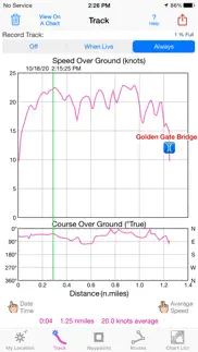
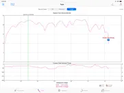
Record tracks as you sail, even in the background. View them on the chart and in a Speed & Course Over Ground graph.
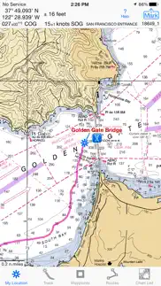
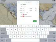
Mark waypoints precisely using topo or satellite maps, place names or addresses, geotagged photos, or by projecting from a known point.
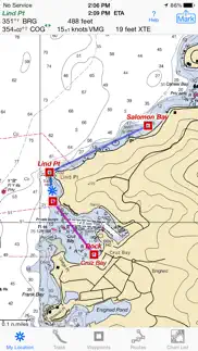
Set a quick GoTo waypoint or a full route and see the course (COG), heading (HDG), bearing (BRG), direction, distance, cross track error (XTE), Velocity Made Good (VMG) and Estimated Time of Arrival (ETA) at your destination and intermediate points. Perfect for racing enthusiasts.
In a Man Overboard (MOB) emergency a single button press marks your current position & starts navigating to it.
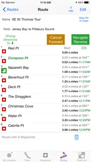
Create customized routes using waypoints, recorded tracks, or imported GPX, KML or TCX files. Advanced route editing.
Send GPX and KML waypoint, route, track and map list files via AirDrop, eMail, Messages, or iCloud Drive.
View the sun & moon position, rise times & set times for any date & place on earth.
Send data to other apps such as Google Earth.
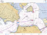
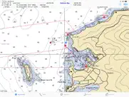
USA NOAA RASTER NAUTICAL CHARTS
Access to all NOAA RNC Charts for USA waters with no extra charge. Download using WiFi or cell service.
Our chart files are optimized to download faster & use less storage memory. Store up to 2200 charts to use anytime at sea without cell service.
Stitches charts & automatically switches between downloaded charts as you sail. Choose detailed or overview charts.
Print & Share chart images overlaid with waypoints, routes & tracks.
Measure distance & direction between any 2 points.
NOAA charts don't include most inland rivers & small lakes. Use our iHikeGPS app for these.
HOW TOS
Tap Help in the app.
Online Manual: isailgps.com
Email developer: lwjames@isailgps.com
RASTER CHARTS VS. VECTOR CHARTS
The National Oceanic & Atmospheric Administration provides both RNC (raster) & ENC (vector) charts.
The great advantage of the high resolution RNC charts used by iSailGPS is the high level of detail produced by professional cartographers that is unobtainable on any vector-based chart. ENC Vector Charts only show a coastline, water depth, navigation aids & minimal details.
These RNC Charts differ from vector charts in that each chart covers a specific area, just as paper nautical charts do. Switches automatically to a new chart when your boat leaves the area covered by the previous chart. For most locations, there are multiple charts at different scales with different levels of detail & areas of coverage.
Paper charts can have multiple panels, each showing a different area or scale. Each digital panel is individually displayed by iSailGPS with a north-up orientation.
Other more expensive marine software uses these same RNC charts. iSail GPS is priced to make it readily available to all boating enthusiasts.
Winner of the Practical Sailor Editors’ Choice Award.
DEVICE REQUIREMENTS
Use iSailGPS on any iOS device even if you don't have a cellular data plan for it. iPhones & WiFi+cellular iPads support full navigation. For WiFi-only iPads & iPod touch, an iOS-compatible external GPS receiver is required to show your location on the water & record tracks. However, you can view charts using the iOS device alone.
Discover a safer and more enjoyable sailing experience with iSailGPS!
😍 Do you love ISailGPS : NOAA USA RNC Charts app? Please share your friends!

Please wait! ISailGPS : NOAA USA RNC Charts app comments loading...
ISailGPS : NOAA USA RNC Charts 9.4.5 Tips, Tricks, Cheats and Rules
What do you think of the ISailGPS : NOAA USA RNC Charts app? Can you share your complaints, experiences, or thoughts about the application with James Associates Inc. and other users?
ISailGPS : NOAA USA RNC Charts 9.4.5 Apps Screenshots & Images
ISailGPS : NOAA USA RNC Charts iphone, ipad, apple watch and apple tv screenshot images, pictures.
| Language | English |
| Price | $7.99 |
| Adult Rating | 4+ years and older |
| Current Version | 9.4.5 |
| Play Store | com.macgpspro.iSailGPS |
| Compatibility | iOS 12.0 or later |
ISailGPS : NOAA USA RNC Charts (Versiyon 9.4.5) Install & Download
The application ISailGPS : NOAA USA RNC Charts was published in the category Navigation on 29 April 2011, Friday and was developed by James Associates Inc. [Developer ID: 351499178]. This program file size is 10.13 MB. This app has been rated by 64 users and has a rating of 3.8 out of 5. ISailGPS : NOAA USA RNC Charts - Navigation app posted on 07 March 2024, Thursday current version is 9.4.5 and works well on iOS 12.0 and higher versions. Google Play ID: com.macgpspro.iSailGPS. Languages supported by the app:
EN Download & Install Now!| App Name | Score | Comments | Price |
I'm continually improving this app so it will be even more useful! This version adds the ability to view a weather report for any location. What's new in iSailGPS when compared with other available NOAA chart apps? • You don't just see waypoints and routes displayed on the chart, you can actually do real great circle navigation to those waypoints and along those routes. You get information such as Estimated Time of Arrival, current bearing, heading and cross-track error, and remaining distances to your intermediate and final destinations. • You don't just see individual charts. Whenever the map projection is compatible (which it is most cases), you can see adjacent charts with their margins removed stitched together seamlessly, even when the chart scales are different. For example you can see the approach chart and the corresponding harbor detail chart both together on the same screen. • You can create, import, edit, export, and navigate both on routes based on a recorded or imported path, and on routes based on a series of waypoints. • iSailGPS's code size is kept very small by efficient programming so in an emergency, you can download it easily even over a weak cell connection. • The current version of iSailGPS runs on the latest devices and also on older devices with older versions of iOS , all the way back to devices such as the iPhone 6. • There is never any confusion over what charts you have available offline. They are clearly listed by NOAA chart name and number, and shown on an overview map. • Check the App Privacy section. We don't know who you are when you are using iSailGPS. We never send your current location or your recorded track to our servers. Hence we cannot and don't use your location data. We cannot and don't provide your location data to anyone else. Unlike other mapping apps that profit from using your location data in ways that do not keep it private, iSailGPS maintains the highest level of data confidentially.
| App Name | Released |
| EVgo EV Chargers | 17 October 2017 |
| KakaoMap - Korea No.1 Map | 27 February 2009 |
| Footpath Route Planner | 07 May 2013 |
| Find My Friends Phone - iMapp | 26 July 2014 |
| Speedometer Simple | 18 November 2014 |
Find on this site the customer service details of ISailGPS : NOAA USA RNC Charts. Besides contact details, the page also offers a brief overview of the digital toy company.
| App Name | Released |
| World Tides 2024 | 14 November 2023 |
| Theodolite | 30 November 2009 |
| Holding Pattern Trainer | 16 August 2011 |
| Land Nav Assistant | 18 May 2012 |
| Cachly - Geocaching | 11 December 2015 |
Discover how specific cryptocurrencies work — and get a bit of each crypto to try out for yourself. Coinbase is the easiest place to buy and sell cryptocurrency. Sign up and get started today.
| App Name | Released |
| Google Chrome | 28 June 2012 |
| 06 October 2010 | |
| SHEIN - Online Fashion | 19 May 2014 |
| 28 April 2011 | |
| PayPal - Send, Shop, Manage | 03 February 2019 |
Looking for comprehensive training in Google Analytics 4? We've compiled the top paid and free GA4 courses available in 2024.
| App Name | Released |
| Incredibox | 27 March 2016 |
| Bloons TD 5 | 15 November 2012 |
| Paprika Recipe Manager 3 | 15 November 2017 |
| Poppy Playtime Chapter 1 | 08 March 2022 |
| Pou | 26 November 2012 |
Each capsule is packed with pure, high-potency nootropic nutrients. No pointless additives. Just 100% natural brainpower. Third-party tested and validated by the Clean Label Project.
Adsterra is the most preferred ad network for those looking for an alternative to AdSense. Adsterra is the ideal choice for new sites with low daily traffic. In order to advertise on the site in Adsterra, like other ad networks, a certain traffic limit, domain age, etc. is required. There are no strict rules.
The easy, affordable way to create your professional portfolio website, store, blog & client galleries. No coding needed. Try free now.
ISailGPS : NOAA USA RNC Charts Comments & Reviews 2024
We transfer money over €4 billion every month. We enable individual and business accounts to save 4 million Euros on bank transfer fees. Want to send free money abroad or transfer money abroad for free? Free international money transfer!
Both Planning and at Sea. The charts are nicely integrated to the user interface making trip planning easy. The planned routes execute well while at sea. My go-to app for coastal navigation.
My favorite app. I have used many apps for marine navigation. I have settled on this beautiful app as my favorite. Did you know that it is one of the only apps in this genre that will work on the iPad1? Not only does it use NOAA charts by our gov't but it can also stitch them together. The documentation is just excellent. I feel that you can become a fan of this application.
this app. I have to give 4stars to put my review in as 1 star gets rejected!!! Don’t buy this app, if you can’t draw a straight line on a chart for way points then you may need this. This app suggests that I take my boat (using way points) through houses and hills. This is just an $8.00 novelty.
App hangs up. Updated app on iPad. No longer works on iPhone. Hangs up during update. Delete, reinstall, won’t reinstall. But fix caused new bugsz
Always Impressed. After investing a little time to understand this app, I found it to be extremely valuable and accurate. I was won over, when we used it to navigate across the Chesapeake Bay at night. The waypoint marker we were heading to was supposed to be a flashing light but the light was out and we were a little uncertain that we were on course. When we suspected we should be at our destination marker we turned on our spot light and found ourselves perched with the marker on our port quarter. Can’t believe this app is only $7.99.
Keeps crashing. I like the detail of the charts. However, it crashed within the first minute of use multiple times. I couldn't get far enough into features to know if they worked or not. After giving up, I shutdown all apps and rebooted iPad. A lot more stable now. Apparently this app doesn't like sharing resources. I do have several other apps open now and so far no crashes. I love the ability to share Waypoints. It's been great prepping for an upcoming trip where I can send back and forth to our travel party our Waypoints for dive sites and moorings along the way. Still nervous about initial instability. will update post following trip where I'll give all the features a good test. Would love to see a bug fix update posted ASAP. On the surface this appears to be a nice utility for those of us bareboating in unfamiliar waters.
Excellent! Add Instrument Panel?. I love iSailGPS! Simple, stable, clear. Upgrade wish: Add an "instrument panel" page, showing just instrument numbers, for use when racing and/or in open ocean: - show: HDG, COG, SOG, DTW, BRG, VMG; use big numerals in vertical list; allow night-mode red numerals - to display: swipe left on instruments at top of My Location display (to return to chart, swipe left on instrument panel).
Great app!. I love this app! It gives me exactly the info I need when racing or just sailing. I’ve set waypoints for all the government and private buoys we use to set our race course. Then all I have to do is create a route by choosing the waypoints to be used for that day’s race. Then I have SOG and bearing and VMG to each mark and more. Amazing! The learning curve is a bit steep, but well worth it. And if I have questions, the developer is super-quick to respond. Highly recommended.
Navigation program. A real navigation program worth far more than its $8.00 cost. A bit tedious loading NOAA charts, but well worth the required effort. Used on recent yacht delivery on St Johns River Florida USA with perfect results. The up to date marked charts big help. Kept me and my crew on track through somewhat complex unfamiliar waters. Prevented two near groundings. Every boater with an I phone should have this program. Perfect for small boats with no other navigation equipment. Shows "course/up" and can be used by anyone with basic boating course qualifications. I hold a US Coast Guard 100 Ton Masters License.
Can’t beat it. I have used this app on my phone to navigate my sailboat at night from San Diego to Catalina and arrived at Avalon dead on the mark and within five minutes of the predicted ETA. While it’s less convenient than a dedicated chart plotter, it gets the job for a fraction of the price.
Well done raster charting. iSailGPS displays raster charts - essentially photo copies of the printed NOAA charts. It shows your position. It can record your track. It can set and store waypoints (but not routes). For $8, that's a huge bargain. There are some problems: The method for downloading charts (they're free) is quirky. The interface has to be learned. But these are small issues compared to the utility of the app.
Don’t waste your money. Useless, doesn’t load charts , really a total waste
Disappointed. This app does not allow you to zoom in far enough. I can understand if it was just a chart app but with GPS in your phone allowing zoom to several feet the chart should also be able to do it. Don’t waste your money.
Tons of individual charts you have to deal with. Nothing about this app is easy. If you just want to measure distances or plan a multi-day trip there is just too much chart confusion.
ISailgps. As a novice to coastal navigation, i have found this app to be awesome. It Works just like a chart plotter but better cause you can save screen images of your routes. I know there's pricier nav apps out there, but for 8 bucks this one is an accurate way to chart your course and see exactly where you are, speed, ETA, waypoints, and easy to use. Just be sure to download your charts before you set sail so you can access them at sea. I'm still learning all it does, but so far it's perfect for my Ga. Coastal navigation .... S/V Glory Days
iSail GPS. Replaces a basic chart plotter. I run in the dark quite a bit, and this app has been very accurate for me. I’m always impressed - basic functions, but it performs very well.
Great AID !. Puget Sound, Strait of Juan de Fuca, US San Juan islands to Blaine. iPhone is now a plotter in my pocket. iPad to iPhone chart downloads, waypoints, routes: do work on one and text to the other instant redundancy. Stitching charts keeps me from “ falling off the edge of the world”. Tip: download high resolution AND wide area charts as well as harbor charts. Ability to sort charts by number would be helpful. For $8.00 I’m impressed and satisfied.
Good simple program. Have tried several programs - this program seems to be the most battery friendly and is a good backup program. Very stable. Main limitation seems to be the app only works w NOAA charts so no international use.
I quit using it. It seems to be an OK sailing app. but I couldn’t get past the way it stitched the “paper" charts together (there seemed to be trouble at the seams, and loading the charts when I needed them, etc). I have SEAiq on also and ended up always using that instead. It’s $10 so also a good value. I wish I hadn’t have spent the money on iSail because I never use it now.
Really great. I have never written an app review before but now I feel compelled to do so! This app allows free downloading of official nautical charts rom the actual NOAA server so there are no issues with being up to date or inaccurate. It's a great balance between simplicity and functionality - the charts themselves, making waypoints and routes, tracking. That's about it. But when you are cruising that's really all you need. I have a vector-based competitor (iSailor) which is also very high tech and very cool and has more functions by far. I thought I would like it better. But in fact the vector information can be ever so slightly off so I never use it in tight quarters. In fact I've started to use this exclusively instead.
Great App and Great Support. My husband and I downloaded this app to use on a race. There was one aspect that we couldn't figure out and we had an answer to our question almost immediately via -mail. Locator works very well. The waypoints were accurate and easy to read. We loved the fact that you could add notes so we knew if we were to make a Port or Starboard turn. Deserves all 5 stars!! Gene and Nellie S/V Sun Chaser
Almost good enough. The photographed map images are obviously not as good as those generated directly from NOAA data, but are quite readable and will be pleasantly familiar to those who have worked with traditional charts. Waypoint management is simple and intuitive, but it's a shame that you cannot stack a set of waypoints as a single route. This is especially unfortunate since the waypoints use dead simple route planning, and no effort is made to keep your vessel afloat, The Track display is disappointing, since it ignores position-at-time, opting instead to display total distance travelled against instantaneous speed. Even with these complaints, I find this to be my favorite (current) marine navigation app in its price range.
Says chart for lakes. Nope. I think we should be able to get our money back when the app developer misleads customers. It states clearly that there are charts for lakes. NOT for the biggest lake in the country. Lake Texoma. I know their are charts, this app just can’t access them. Buyer be ware.
Fast, easy, intuitive. And very inexpensive. It's easy to learn, and, though I'm a died-in-the-wool plotter and dividers kinda sailor, I love the ease of making and recording routes. Paper charts still have their uses -- still the best way in MHO to get an overview, but at night in the wind, my i-pad with this app is a more practical backup to my chart plotter than paper. And one more thing -- when you read that a chart has been changed in the LNM, you'll be able to download it fairly soon and for free. An earlier rater found the program deficient because it does not have a course-up feature. That would be nice, but until then, I can turn the iPad.
No longer compares to better hi tech (free) charts. Used to love this app. Excellent customer support, excellent updates. HOWEVER, since getting the Simrad/C-Map app, the technological behind the times issues in the iSail app have become unfortunately glaringly evident. The biggest issue is of course the ability (or lack there of) to auto route. You just hold your finger on a point in the Simrad/C-map app and it creates all the waypoints and the entire route automatically for you. No more having to mark waypoint after waypoint in order to create a route which is an incredibly slow and inefficient way of doing business now. The crazy way that iSailForces you to mark a spot in order to create a waypoint as opposed to just holding your finger down is like using MS-DOS compared to Windows 10. Finally, given the new dynamic mapping capabilities which is free technology, the Raster maps are really old school. This is quite evident if you use a chart plotter and compare your ability to shade, create safety zones, colorize and customize different depth levels compared to the limited, and inflexible raster maps. The Simrad/C-map app uses the dynamic chart which, while not as sophisticated as the chartplotter obviously, still allows for more flexibility than the Raster chart (for instance, when you zoom to a very small area, the raster chart loses resolution and becomes blurry. This does not happen with the dynamic chart). With all that said, I still keep this app as my backup in case for some reason my Simrad app crashes along with my chartplotter. It will get you there and back. It used to be the best but now, it needs a serious complete technological renovation in order to keep up with the competition.
Great customer service. I couldn’t find the specific chart for the area , Friday Harbor, San Juan islands, Wa. I left a message and he called me back on Sunday afternoon and helped download the chart I needed. Thanks
Needs a lot of work on usability. The designer of this software made some rather inexplicable decisions that make it much less intuitive to use. Some suggestions for improvement: 1. Let the user download chart KITS not individual charts. By requiring me to download individual charts I am almost guaranteed to find myself in a tiny, complicated harbor without the local chart and no cell signal. 2. Use the current map focal point to load the local chart rather than loading based on my current location. Sometimes I like to see the map of where I'm going BEFORE I get there (and I do not want to have to dig the chart up by name when I'm trying to steer a boat). 3. Add "use map" to the "add waypoints" screen. Does anyone really enter waypoints by manually entering lat/long coordinates??? Kind of impossible without a paper chart for reference! As it is right now this software is kind of useless for anything but simple day sailing where you will only traverse 2 or 3 charts in one day.
Great Little App. I just wanted an app that I could use for viewing NOAA raster charts. This does the job plus so much more. I like that you can download the charts right to your phone so they are always available whether you have cell phone service or not. The app itself doesn’t take up much space on your phone which is another plus. For under $10 you can’t go wrong with this app folks.
Not detailed. This app is not detailed at all. The layout is horrible and confusing. The charts are not detailed enough. I don’t recommend you get this app.
ISailGPS is GREAT. Really a very useful app with lots of functionality though not totally intuitive - need to review the instructions. The charts alone make the app worth having. Use extensively while sea kayaking. Strongly recommended
Great apps!. I purchased both iSail and iHike apps this year and they are both TERRIFIC! They were easy to download and easy to used. I sailed both offshore and inside small harbors in New England and found the iSail app to be incredibly useful. I chartered a sailboat this year and the chartplotter mounted on the boat was old and lacked detail. I found the iSail app especially useful when going in and out of small harbors, which required knowing precisely where I was relative to the shallow areas, which I needed to stay away from. It was no problem holding my iphone while steering the boat. I still brought hard copy maps and used the boat's compass, but this app greatly enhanced my ability to safely navigate, especially in tight places. iHike performed just as well when I went horseback riding on 80 miles of unmarked trails in Colorado in a area that was "off the grid" (I gave a separate review on the iHike site). Thanks for making such great apps!
SFBay. No inland water navigation markings- useless for inland bay waters
Excellent support. I downloaded iSailGPS Yesterday, aiming to use a Dual XGPS170 Bluetooth device (not typical). Initially some confusion, but email from Larry James cleared things up right away. Support is first-rate. Love the app, but will wait for real-world experience. However, the developer is as responsive as can be. Rarely see such excellent support. Thanks Larry James!
App is amazing. I use this all the time to track speed, location and get a solid feel for the area before going to new locations. I few suggestions First would be an apple watch app that maybe includes basic stats such as speed direction, ETA( if using waypoints) distance traveled. Second would be to offer the ability to set up float plan sending with way points Third ability to export to a computer version for sharing purposes. Lastly the option to set up borders on the chart that maybe vibrates/plays a tone on the device. This could be used to mark under water structures to stay away from or even stay on course with out watching the screen the whole time.
Maps compass locked. The maps are locked to north and can’t be rotated. So you have to remove your iPad from the mount, lock rotation and turn it to read the text on a chart. As this makes the app useless to me, it gets a 1 star. In the help, the author say he listens. I emailed, but got no response.
Works great. I have been using it for 8 years. Tracked to Bermuda BVI and Florida to Baltimore. Charts are free mine has no subscription
Excellent App!. I will preface by saying that I have never used a charting app before so my baseline is limited. That said, I found the app very intuitive and easy to use when navigating a sailboat through some reefs while sailing from St. Croix USVI to Fajardo, Puerto Rico. I also appreciated the very prompt pre-purchase e-mail response from the app developer to a question of mine.
Love it!. My wife and I have a 38' Hughes sloop and we put this app to the test this past weekend on Monterey Bay with flawless results. Get yourself a waterproof iPad case, download the charts for your area (make sure to get harbor detail charts), setup your routes in advance and you're good to go. I had just received new hard copies of local charts and those downloaded in iSail (free) were identical. While it wasn't a necessity, I tested route following from Monterey to Moss Landing via a few designated waypoints on Friday with perfect results. I then used the tracking feature to track my distance traveled under sail and average speeds during a leisurely sail on Sunday with equally perfect results. I've also shown this app to a few other sailors who have since downloaded and are equally impressed. Thank you iSail!
Excellent App. I’ve been using this app for about a year and I’m extremely happy with it. I can set waypoints and routes right on the app just like I would on a chart. Then follow the route, and even reverse it on my iPad or iPhone. I can send a route from my iPad to my iPhone and it brings the waypoints with it. You can take a screenshot of the route and print it out, so you can check off each waypoint as you pass it. They even added the latitude and longitude of each waypoint to the route screen. They’re very responsive and I highly recommend this app.
Works way better than I thought!!. The noaa charts are great. It's intuitive, tracks very well. Since this is the 3rd gps program for sailing on my iphone, I know what I want from the App. I was able to set waypoints and plot a route pretty easily. When you turn on tracking it works really well. Like showing details of us circling to Anchor and later motoring on a dingy to shore and back. The only caveat is if you forget to turn off the tracking when you get home it will continue to track and delete your previous tracks when the memory becomes full. One of the interesting features is the ability to email a copy of the chart with your track and current location straight off the app to your friends or to post on Facebook. I haven't tried it yet but it's an interesting feature. The only thing that I had spent time figuring out was how to change the course heading and bearing from true to magnetic. If you click the "help" button, it's got a lot of details on how to use the app. And of course you know that because it relies on the GPS on your phone you don't need to be connected to your 4G or Wi-Fi. Just remember to download the charts before you leave home. I'm giving it a four star, but it should actually be 4.5. When I use the app again I will further update. All the other crew on the boat were also very impressed and said they are going to download the app.
I like it!. I use this app in combination with a vector chart app. The NOAA charts are much better than vector charts at displaying names of places and features. I use iSail for planning and general navigation, then switch to the vector app when going into tight places where their extra detail and course-up feature is helpful. It is a bit hard to be sure you have downloaded all the charts you will need for a cruise. It would be very helpful if the "Coastline Locator" feature would show all the NOAA charts available in one color, then the chart you have already downloaded in another.
Thought this would work for lakes in my area but wrong!!. I bought this to use on lakes that I boat on but to my dismay none of the lakes have charts that I could find so this app is totally worthless to me. I guess it’s only for boating on the ocean or coastal areas.
Superb App. Accessing the charts is quick and easy. Amateur sailors such as myself will find this to be the perfect app. While it has tracks and waypoints, its not bloated with extra bells and whistles that would only confuse me. For me, all those fancy do-dahs only hinder my experience. These charts are the real deal, just like the paper charts only on my iphone. The price is great too. Highly recommended.
Great for the San Francisco Bay!. Works great. I prefer it to my chart plotter on the boat. It automatically loads the charts. Love it!
sailor/boater/etc. First, this isn't going to replace your chart plotter or other $500+ device, so if that's your purpose move on; however, for a reasonable cost ($8), this program does provide great tracking and waypoint information against free NOAA charts. I found it to be user friendly, instructions page is concise and well laid out, and it displays information well. Its a strong recommendation from my experience, for sailing and boating
iSailGPS, I LOVE it!. This is, hands down, my FAVORITE app. There are others that I use more often, but only because we're only out on the boat now and then, and only in the summer (this being Alaska, winter is NOT conducive to boating). I think that it is fantastic that I can track our progress from the passenger side (or anywhere else) and make sure my husband is aware of any possible obstacles that I see on the chart, that may, or may not, be showing up on the main GPS. The only improvement I would like is the tracking line. It's kind of hit-or-miss. Some times is shows, sometimes it doesn't. No biggie, but it would be nice if it were more consistent.
Solid app, and reliable as a backup plotter. I like how this app uses the straight NOAA raster charts. Also don’t have the login and in app purchase issues that I’ve had with competitors.
Great Chart Plotter!. Any of the negative reviews, and there are only a few, cleary just downloaded the app and didn’t bother to learn it. This app is amazing! I do wish I could figure out how to download additional waypoint icons though. Anchorage, bouy, ramp, hoist, pump out, etc. it may be possible but I can’t figure out. Still tho, great map. One tip, when creating waypoints, make sure to use in insets or zoom way in because, initially, when I was creating them, I learned that they were way off!
Outstanding. I’ve been using this app for about a year and I am throughly impressed and happy with it.
iSailGPS. From the first time we used this app, we were impressed with its ease of use and clear interface. We downloaded the charts we needed with no problems. Many guest crew members have used it successfully and found it easy to interpret. We used it to navigate from New Bern, NC to the Delaware River in NJ and currently on the Chesapeake with very few problems. A great app for the price!
Did you know that you can earn 25 USD from our site just by registering? Get $25 for free by joining Payoneer!
Imagine you at your best. All the time. Picture yourself at your sharpest and most productive. Your most alert and focused. Your most lucid, creative and confident. At work. At play. In every area of your life. Add Mind Lab Pro® v4.0 to your daily routine and uncap your true potential. Buy Now!
Terrible. Can only get very large scale maps for Canadian waters. Don't buy for Canada
Canada?. We thought this would be a good app as we seen good reviews.....does not work for Canadian waters......did not even get to try.....waste of money for us
Adsterra is the most preferred ad network for those looking for an alternative to AdSense. Adsterra is the ideal choice for new sites with low daily traffic. In order to advertise on the site in Adsterra, like other ad networks, a certain traffic limit, domain age, etc. is required. There are no strict rules. Sign up!
No coarse up. No coarse up makes it useless to me. Otherwise seems like a nice app.
Great app. I bought this to rent powerboats in the keys and it has been very reliable. I love the the maps are not an additional cost. Great value for the price
Excellent! Add Instrument Panel?. I love iSailGPS! Simple, stable, clear. Upgrade wish: Add an "instrument panel" page, showing just instrument numbers, for use when racing and/or in open ocean: - show: HDG, COG, SOG, DTW, BRG, VMG; use big numerals in vertical list; allow night-mode red numerals - to display: swipe left on instruments at top of My Location display (to return to chart, swipe left on instrument panel).
ios5 Problems. ios5 problems maps do not display This app is a good value in nautical gps navigation. It's uses NOAA charts that are downloaded and stored on the iPad. The charts are free. It displays realtime location and tracking via gps, wifi or cell phone provider. It will use internal or external gps devices depending on your devices capabilities. Would like to see satellite imagery overlay as a future feature. Good job.
Doesn't work for me. There are no maps for the Tennessee River, I want my money back.
good app. I Think this is a good app, for the money. I was able to download the NOAA charts for the Great Lakes with little trouble. The GPS tracking worked well. For little $$, I have a good working navigation program.
Excellent app. It's a lifesaver at an excellent price
Good waypoints, charting not great.. The waypoint functionality is good, but Marine US has much better chart functionality. It's annoying that you have to download individual charts.
Miss. App does not work. No maps to be seen. Very nice information under help but no maps are visual and it cannot find my location, using multiple wifi connections to check.
Robert C. Fern. I've never written a review before and I've purchased hundreds of apps but this app is so bad that I felt compelled to warn anyone that they should not buy it. AWEFUL!!!
I quit using it. It seems to be an OK sailing app. but I couldn’t get past the way it stitched the “paper" charts together (there seemed to be trouble at the seams, and loading the charts when I needed them, etc). I have SEAiq on also and ended up always using that instead. It’s $10 so also a good value. I wish I hadn’t have spent the money on iSail because I never use it now.
Excellent navigation app!. I use this app every time I sail. It is accurate, has many great options and has a very detailed help section. I reported a minor issue and a new version with the fix was released within a few days.
Waste of money. Waste of money, don't buy it. Very difficult to make a new waypoint and don't change from a chart to another chart
X marks the spot. Great for me. Besides a backup Nav-aid I've been using iSailGPS for sharing the location of ship wrecks and dives spots with my buddies. I love that we can all import/export each others waypoints at anytime. If your into sailing, diving and/or underwater photography then I can definitely recommend this app.
Nice sailing app. Perfect for day sailing!
Mr.. All the staff from check in to exit were great. The iPhone issue was corrected with some effort. Henry was very skilled. Thanks so much:)
Unuseable!. Sorry that I bought this. Slow. Unworkable map loading even on wifi!
Needs a little work.. The program is okay, but it has a ways to go. For the price I guess it is adequate.
Great app. I use this app when I go open water rowing. The iPhone is in a waterproof pouch in a storage compartment of the shell( boat). After the row, my track is displayed on the beautiful noaa map. I hope that a companion apple watch app will be offered so that the iPhone app can be controlled from the wrist. This is a wonderful app.
Server problems. Constantly fails when downloading charts. Do not buy!
Great App. Love this App. While sailing last year, my friend had it on his iPhone. I enjoyed watching where we were going with this App…it was so simple! The Help Menu is amazing - and the App does exactly what it says it will do! When I got my iPhone for Christmas, the first App that I bought was iSailGPS. Looking forward to Spring and Sailing!
Garbage. Save your money!!! The writers of the software took photos of the nav charts. What is worse is that some such as Everglades City area, were not taken directly above chart. Also when the chart has panels the match lines have spaces..... You get what you pay for! Cheapo software.
Great tool!. Used for first time on a mark boat at Yngling North American Championship regatta. Very easy to use. Made verification of mark locations simple and adjusting courses a breeze using Go To functions. Highly recommend.
Great backup. Great program for the money. Simple to use after you know how. Charts are great. Not as nice as my BnG chart plotter on my boat. But as a captain doing boat transport I will defiantly be carrying this as a back up. Also very useful for rout planing when not on the boat.
Good and Simple. I have played with this app for some time and I really like it. NOAA charts work great and waypoints are easy to add. Sometimes it's a bit slow to load the charts but other than that it works great.
Great app!!. Very reliable. Accurate. Advanced features. Great for the ipad(with gps). A bit of a battery hog in track mode so be prepared with an alt energy source.
Clumsy. Hard to use
Capt. Ray. Not a user friendly software, not ready for marine navigation.
Not recommended. This app seems to consume the processor, as zooming in / out and moving the map around takes several seconds to respond, and battery life is short when its running. It was the only app I could find to show GPS position on a NOAA chart, but it really needs work to make it more responsive.