Tactical Navigator App Reviews
Tactical Navigator App Description & Overview
What is tactical navigator app? Tactical Navigator (“TacNav”) is a mobile application tool for communications, operations, and outdoor planning--perfect for any military or outdoor enthusiast! Whether you want to save a training location or your best fishing spot, this app is for you.
Tactical Navigator comes with the following features:
Basic App Features
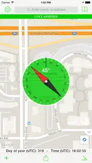
• Compass
• Day of Year & UTC Time always visible
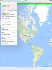
• Add many locations to the map at the same time
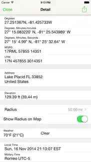
• Coordinate systems: Degrees, DM.m, DMS, MGRS, and UTM
• Search by address or any coordinate format
• Elevation
• Current weather conditions and temperature
• Local and Military time
• Choice of Metric or Imperial measurement values
Enhanced Map Actions
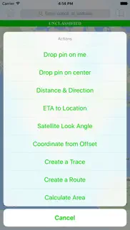
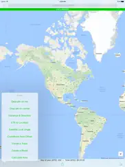
• Distance & Direction
• ETA to a location
• Calculate a Satellite Look Angle
• Calculate an offset coordinate given distance & direction
• Trace a path
• Routes (great for land navigation)
• Calculate Area
• Add a radius around a location
Other Great Features
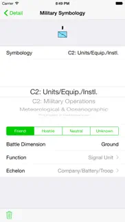
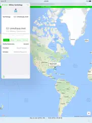
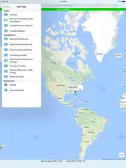
• Use MIL-STD-2525C symbology to change your location's icon
• Save notes to your saved locations
• Open Turn-by-Turn apps for driving directions with 3rd party apps (Apple Maps, Google Maps™, and Waze)
• Universal application for use on iPhone or iPad
• iCloud integration to sync across your devices and auto-backup your data
• Angle of Device (ex. to assist positioning a ground satellite)
• Share your data with other TacNav users via encrypted AirDrop™ or email
• Export your data to KML
Thank you for your support and using TacNav.
US Army LTC Kevin Militello - Owner & Developer
Disclaimers:
• Continued use of GPS running in the background can dramatically decrease battery life
• TacNav is not endorsed by any government agency
😍 Do you love Tactical Navigator app? Please share your friends!

Please wait! Tactical Navigator app comments loading...
Tactical Navigator 2.6.2 Tips, Tricks, Cheats and Rules
What do you think of the Tactical Navigator app? Can you share your complaints, experiences, or thoughts about the application with Orange Clover LLC and other users?
Tactical Navigator 2.6.2 Apps Screenshots & Images
Tactical Navigator iphone, ipad, apple watch and apple tv screenshot images, pictures.
| Language | English |
| Price | $4.99 |
| Adult Rating | 4+ years and older |
| Current Version | 2.6.2 |
| Play Store | com.kmil.tacnav |
| Compatibility | iOS 13.0 or later |
Tactical Navigator (Versiyon 2.6.2) Install & Download
The application Tactical Navigator was published in the category Navigation on 01 July 2010, Thursday and was developed by Orange Clover LLC [Developer ID: 377637033]. This program file size is 81.33 MB. This app has been rated by 9 users and has a rating of 3.6 out of 5. Tactical Navigator - Navigation app posted on 11 September 2022, Sunday current version is 2.6.2 and works well on iOS 13.0 and higher versions. Google Play ID: com.kmil.tacnav. Languages supported by the app:
EN Download & Install Now!| App Name | Score | Comments | Price |
Ready for iOS 16!
| App Name | Released |
| Footpath Route Planner | 07 May 2013 |
| PlugShare | 07 March 2011 |
| Volta Charging | 11 June 2015 |
| Citi Bike | 21 May 2013 |
| KakaoMap - Korea No.1 Map | 27 February 2009 |
Find on this site the customer service details of Tactical Navigator. Besides contact details, the page also offers a brief overview of the digital toy company.
| App Name | Released |
| WakeWatch | 31 March 2016 |
| StarPilot | 03 March 2010 |
| Theodolite | 30 November 2009 |
| Light Pollution Map | 20 September 2020 |
| Los Angeles Zoo - LA ZooMap | 10 May 2022 |
Discover how specific cryptocurrencies work — and get a bit of each crypto to try out for yourself. Coinbase is the easiest place to buy and sell cryptocurrency. Sign up and get started today.
| App Name | Released |
| Delta - Game Emulator | 17 April 2024 |
| Amazon Prime Video | 31 July 2012 |
| X | 09 October 2009 |
| 28 April 2011 | |
| Airbnb | 10 November 2010 |
Looking for comprehensive training in Google Analytics 4? We've compiled the top paid and free GA4 courses available in 2024.
| App Name | Released |
| AnkiMobile Flashcards | 26 May 2010 |
| The Wonder Weeks | 30 May 2012 |
| Shadowrocket | 13 April 2015 |
| Poppy Playtime Chapter 1 | 08 March 2022 |
| HotSchedules | 30 October 2008 |
Each capsule is packed with pure, high-potency nootropic nutrients. No pointless additives. Just 100% natural brainpower. Third-party tested and validated by the Clean Label Project.
Adsterra is the most preferred ad network for those looking for an alternative to AdSense. Adsterra is the ideal choice for new sites with low daily traffic. In order to advertise on the site in Adsterra, like other ad networks, a certain traffic limit, domain age, etc. is required. There are no strict rules.
The easy, affordable way to create your professional portfolio website, store, blog & client galleries. No coding needed. Try free now.
Tactical Navigator Comments & Reviews 2024
We transfer money over €4 billion every month. We enable individual and business accounts to save 4 million Euros on bank transfer fees. Want to send free money abroad or transfer money abroad for free? Free international money transfer!
User. Great ap everyone should get this one.
Mgrs conversion. I like this app, I just wish the mgrs conversion would be in wgs84 and not nad27
Tacnav. Excellent app! Very usefull to orient oneself in the woods.. And all the extras that are included are really awesome!
Good stuff. Got me the info I needed and the map support is amazing
My recommendation. I'm in the military and teach my soldiers landnavigation for deployments, this is what us Soldiers want to see on this app. - you have true north and magnetic north and the declination(g-m angle) but why not make it calculate to Grid North, I don't know how many hundreds of times I could of used that feature to make my job 30% more efficient. That one simple feature will probably get 20% more sales for you from guys like me in just the army alone. - I haven't checked but if you do a night landnav add-on to this app, give us the option to use red, blue or green so the enemy doesn't see us. Make it simple and a font large enough to read when moving fast. - give us a way to dim down the brightness of the screen. - lacks descriptions for each option in settings and I couldn't figure out how to set the third time zone on top right. - lastly, it requires google maps using an Internet connection, need an offline map option so we can browse to topographic maps we have or provide us with a way to get those maps. Orr let us take a picture of a map and import it into your app for use w/ an option to pick the correct scale 1:50,000 or 1:24,000 - with all of this I would gladly pay $10.00. Without it it's just another app I can never use.
No update since Oct. 2015.. Very good app but I just recently downloaded it and it works as advertised. Curious if the devs are still keeping up with this app or is it going the way of the dodo when it comes to updates?
Awesome App!. This app is great! Just used it on a Land Nav course and I was within 5 meters of all the points. Highly recommend to other military
Love it so far. As of right now I love it. Useful and spot on. Thank you and I hope the updates ( if any ) are top notch.
Great app. Couldn't ask for more. I am a professional skydiver, and former military man. Using this app makes my job so much easier. I can place pins where I am taking off from and where I am landing at. Comparing elevation offsets and doing real time distance and direction can at times literally be a life saver. The different unit values and display functions would really come in handy for anyone trying to compare lat/longs to the MGRS system. This is the first review I've written for an app. Good job guys.
Needs an offline map mode.. Would be nice if it had a way to save a certain area for offline viewing sense if cellular towers were down and I was stuck out there for example. Just suggesting I would rate it five stars.
I-I-I-I-I-I LIKE IT!!!. Wish I had this when I was a young infantry platoon leader/company commander. Go to, young captain! Good hunting and good luck..... Chuck Pelto LTC, IN (ret) P.S. It works even better in an iPad with 3G capabilities.....
Doesn't run. On 3GS, app won't run. I get a screen that says it's "loading" for about 1 second. Then it goes back to the desktop. Nothing.
Awesome app!!. I love this app it located me in the middle if nowhere with no reception!
Great app! Please add support for custom overlays!. I’ve been using this app weekly since it first came out and it’s still best in class after all this time! I definitely recommend this app for anyone needing to plot points with MGRS coordinates and elevation data. The only thing I find lacking is the ability to draw custom line/polygon overlays on top of the map to delineate airspace or other area boundaries (something similar to the routes feature, but with the waypoint markers hidden and locked so they can’t be accidentally moved). Please keep up the great work!
Total waste. Would have been better if it worked. Started program once, looked a the diffrent screens and settings, then the screen went black and it never worked again.
Good overall. Would be nice to see a feature that pinpoints your location giving you the MGRS, and then let's you enter a MGRS point to navigate to and shows the compass pointing in the direction you need to go and updates gps frequently for accuracy, possibly include terrain maps as well/metric units. Great app though
Woodsman. This app is great for placing trail cameras, deer stands and unique spots in the timber and locating them later and sending the information to others. It out to help in military land navigation purposes as well.
Meh. Used overseas but sluggish...
Great reference tool. Working in the field or for personal Rec, handy little app to have. Perfect for lat/long and MGRS conversions.
Military Navigation Indeed. Anyone within D.O.D will appreciate this app
Works good for military. I'm out on a FOB conducting training and this app was useful to double-check my land nav skills.
Why did you change it???. As a member of our armed forces, the ability to quickly plot and determine direction and distance is important. Since the update, I am unable to manipulate the waypoints to enter a grid. This was the most useful feature in previous versions. Please provide this functionality again!!
Elevation. I’ve been using this app for 10 years and now the elevation won’t update! Tried it in 2 different phones.
Great tool. It make Landing Navigation a lot Easier. Awesome tool.
Top notch grade A app. This app does everything it says it will. I use this app all the time for all my navigation needs. A big thank you to the developer!
Fix it or refund me. Worked once then tried to reopen it an it goes to load page and closes. I have not been able to reopen or use it since. And I have reported it to them and have not recieved any response. Fix it or refund my money.
Won't get passed the loading page. I sure hope they fix this problem. It seems to me like it's a hit-an-miss with this app if it works or not.
OMG!!!. I have been looking for two years for an application like this! The conversion from MilGrid to Lat/Long is awesome for frequency managers!!! Great for UHF TACSAT as well with the new Satellite Az/El calculations. Compared MilGrids to those on paper for our training areas and it is pretty dead on. It's hard to get a true 10-digit grid. And did I mention it was a great help for a night land nav course! Great app!
Great!!!. I have been looking for an app like this for a long time. I am glad I finally found it.
The only MGRS app. The only app to use if you need to convert to MGRS.
Great potential. I actually use apps like this in the field and test their accuracy for ranging targets for precision engagements on tactical operations in the law enforcement arena. I look for map ruler features to range targets based on GPS locks. It's never perfect but it has been getting better for operational applications. Yes milling with a mildot master is great, but I like having several options. This app has become my new range buddy (with the pin dropping feature that provides distance) so I can test it out and so far I'm pleased with it. Odds are I won't take my phone out for navigation unless I want to check my routes in a RON to transfer to my map, but this app no doubt simplifies it. So far the only changes I'd like to see is to trash the digi homescreen background or switch to a multicam - or provide optional camo for fun. Also the light button would be awesome if it activated the iPhone 4's LED. I'll be testing the app more, but I definitely recommend it.
Great. Use this every day in the military and hasn't failed me once !
Your update. I like the old version better a compass might help but every one think change is better nope.
Works well!. I've wanted an app like this for some time. Would be nice to be able to load CADRG files and use without an internet connection.
New Version ruins a great app. I've used this app since its introduction. It has been extremely useful in the field. "Unclassified bar" seems like a waste of screen real estate, but it's forgivable for an otherwise excellent tool. Keep up the improvements. It would be useful to have waypoint route calculations based on a programmable/custom rate of progress -- handy for planning purposes. You could also add in rough calculations for foot, vehicular-ground, helo, air, and sea/amphib that take into account any available environmental data.
Very useful. Needed to go report my location as a possible FTX site. Was able to quickly get a 10 digit grid and plot it on a map easily and accurately.
Useful for army training. Helpful reference tool
Good app!. Well worth the money!!!
Won't open. Can't open, running 3.1.3
Top notch app. Works like a dream! I have all my routes lined out in case of a pandemic.
UPDATE!!!!!!!!!!!!!!. I love this thing but it doesn't work with the current OS at least on my phone thats the Error Im getting...can't wait to use it again
Solid but room for improvement. I’ve used this application for at least 7 years, it has been great but I believe it’s reached a critical static point. For years I recommended this application to cohorts and friends alike but I’ve ceased doing so for the following reasons. In my opinion, it would be a 5 star app I would again recommend to others if it had these items. -Ability to download maps offline and store locally. -Custom layover with geometric shapes and labeling. -CarPlay Support. These are two huge markets where this application lacks and I have to recommend ATAK or it’s civilian variant to others. I use ATAK currently however prior to that I used APASS and this application very frequently. But they fallen behind the power curve of relevancy.
Great app. Worth it.. Update just made this thing invaluable! Great for field use, I use it almost everyday. Grids are accurate. Needs zoom on current location when opening field map. I have to tap about twenty times to get to 50 to 1.
Improve. It's a great app for the military but being able to label waypoints and plan routes would make it perfect
Did you know that you can earn 25 USD from our site just by registering? Get $25 for free by joining Payoneer!
Save your time and just download it!!. This app rocks. There are plenty of GPS apps out there, I've bought heaps of them, but for MGRS functionality nothing tops it. Heaps of great functions and the map caching is great when out of internet coverage, still allowing you to get the job done. Great military app, but also cool for touristy nav stuff.
Tacticool ;). Very slick app, not a street address GPS - great for use in the bush The flashlight is a handy option too!
Imagine you at your best. All the time. Picture yourself at your sharpest and most productive. Your most alert and focused. Your most lucid, creative and confident. At work. At play. In every area of your life. Add Mind Lab Pro® v4.0 to your daily routine and uncap your true potential. Buy Now!
Works Awesome. Canadian SigOp, Use it all the time at work. Love it.
Adsterra is the most preferred ad network for those looking for an alternative to AdSense. Adsterra is the ideal choice for new sites with low daily traffic. In order to advertise on the site in Adsterra, like other ad networks, a certain traffic limit, domain age, etc. is required. There are no strict rules. Sign up!