Marine US App Reviews
Marine US App Description & Overview
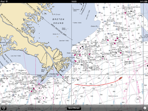
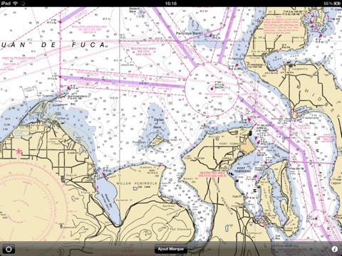
What is marine us app? Marine US is an iPhone/iPad universal application which gives you access to all the catalogue of nautical raster charts for USA (from NOAA Hydrographic Service material)
One of the biggest features in Marine GeoGarage service is that the charts are tied to the GeoGarage server : so no need to purchase or reload charts.
This means that the chart data will be always updated, constantly changing when NOAA releases new updated charts.
Marine US uses the embedded GPS to display the track of your boat in real-time on the multi-touch scrolling and zooming nautical chart.
Waypoint plotting with course and distance to the boat are the additional features of this basic but user-friendly mobile app.
😍 Do you love Marine US app? Please share your friends!

Please wait! Marine US app comments loading...
Marine US 1.0.5 Tips, Tricks, Cheats and Rules
What do you think of the Marine US app? Can you share your complaints, experiences, or thoughts about the application with GeoGarage and other users?
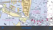
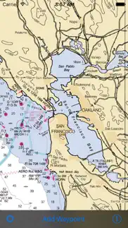
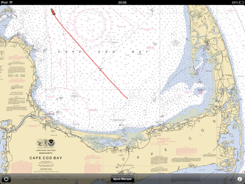
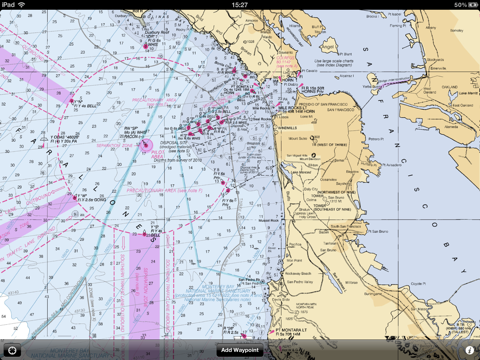
Marine US 1.0.5 Apps Screenshots & Images
Marine US iphone, ipad, apple watch and apple tv screenshot images, pictures.
| Language | English |
| Price | $5.99 |
| Adult Rating | 4+ years and older |
| Current Version | 1.0.5 |
| Play Store | com.justmagic.Marine-US |
| Compatibility | iOS 6.0 or later |
Marine US (Versiyon 1.0.5) Install & Download
The application Marine US was published in the category Navigation on 15 June 2010, Tuesday and was developed by GeoGarage [Developer ID: 372376618]. This program file size is 2.08 MB. This app has been rated by 5 users and has a rating of 3 out of 5. Marine US - Navigation app posted on 10 January 2016, Sunday current version is 1.0.5 and works well on iOS 6.0 and higher versions. Google Play ID: com.justmagic.Marine-US. Languages supported by the app:
EN FR Download & Install Now!| App Name | Score | Comments | Price |
| Marine NZ Reviews | 1 | 2 | $5.99 |
This app has been updated by Apple to display the Apple Watch app icon. Fixed a bug with the iOS version 7.2.1.
| App Name | Released |
| PlugShare | 07 March 2011 |
| KakaoMap - Korea No.1 Map | 27 February 2009 |
| Speedometer Simple | 18 November 2014 |
| Neshan Map | 04 May 2023 |
| EVgo EV Chargers | 17 October 2017 |
Find on this site the customer service details of Marine US. Besides contact details, the page also offers a brief overview of the digital toy company.
| App Name | Released |
| BLM Public Lands Map Guide USA | 27 December 2020 |
| Speedometer 55 Pro. GPS kit. | 10 June 2012 |
| Distance Calculator Pro | 19 January 2017 |
| Wasatch Backcountry Skiing Map | 01 October 2013 |
| Ski Tracks | 05 April 2010 |
Discover how specific cryptocurrencies work — and get a bit of each crypto to try out for yourself. Coinbase is the easiest place to buy and sell cryptocurrency. Sign up and get started today.
| App Name | Released |
| Amazon Prime Video | 31 July 2012 |
| Google Maps | 12 December 2012 |
| B.A.A. Racing App | 25 March 2024 |
| Airbnb | 10 November 2010 |
| Cash App | 16 October 2013 |
Looking for comprehensive training in Google Analytics 4? We've compiled the top paid and free GA4 courses available in 2024.
| App Name | Released |
| Potion Permit | 06 February 2024 |
| Bloons TD 5 | 15 November 2012 |
| Muse Dash | 14 June 2018 |
| Unpacking | 24 August 2023 |
| AnkiMobile Flashcards | 26 May 2010 |
Each capsule is packed with pure, high-potency nootropic nutrients. No pointless additives. Just 100% natural brainpower. Third-party tested and validated by the Clean Label Project.
Adsterra is the most preferred ad network for those looking for an alternative to AdSense. Adsterra is the ideal choice for new sites with low daily traffic. In order to advertise on the site in Adsterra, like other ad networks, a certain traffic limit, domain age, etc. is required. There are no strict rules.
The easy, affordable way to create your professional portfolio website, store, blog & client galleries. No coding needed. Try free now.
Marine US Comments & Reviews 2024
We transfer money over €4 billion every month. We enable individual and business accounts to save 4 million Euros on bank transfer fees. Want to send free money abroad or transfer money abroad for free? Free international money transfer!
Great app in the Fl Keys!. My husband and I used this app to navigate off the Florida Keys. It worked great and was quite accurate with location on snorkeling and fishing spots.
Great app. Good as most of the 30 dollar sea nav aps that are out there! Thanks.
Awesome alternative to paper charts. This is a great application. It gives me detailed NOAA charts, at any scale, of any location. I use it to study a route and plot waypoints before I take a trip. I use it as a backup on my boat. I use it so passengers can see where we are and where we're headed without messing with oversized paper charts or crowding me at the helm. I have the Furuno Navnet 3D on my boat -- as state-of-the-art as you can get in navigation. Sure, it can do a lot more. But for $5.99 (compared with $8,000 for the Furuno), Marine US is one heck of a wingman.
Charts not up to date. Just bought this to find the latest buoy locations in Moriches Bay, Long Island NY following explicit instructions for passage from TowBoat US. This app has old NOAA charts that do not show the new buoy locations!
Great app. Let's face it. Most of us have gps these days anyway. This is a great way to plan a course without dragging out the huge charts. Not for long sailing trips, but perfect for the day trips around the Chesapeake. Well worth the $5.99.
Great start. Not up to the website version yet. But a great start.
Excellente!. Love it
Great start. Is there anyway you can add a route function? Or at least be able to know the lat/long and course of the waypoints. Basically add the capability of the desktop program that the Producers have duplicated to the app. All you can do is view the chart and drop a waypoint. But there is zero amplifying information.
Draws pretty pix, that's it.... Nice images but no interface at all, not even the basics.
Waste of money. Don't make the mistake I did. Once I see this review is posted it will be deleted. Problems don't start to show their full glory at first. Shameful.
Great for most, just not in the Keys. This app is exactly what it says, a compilation of charts. Unfortunately, the charts they chose for the Florida Keys have almost NO information, making this virtually useless for me. If you boat in an area with good charts (most ANYWHERE else from what I can tell) it'd be great!
No good after ios9 upgrade. After ios9 upgrade the NOAA maps won't show. It only shows the ground level maps on both my iPhone and iPad. Before it worked great.
Works ok for the price but very basic. Would've given 2 stars but the low price makes it 3. Extremely basic. If u go to an area or zoom level that u did not view while connected, u can't use it while offline. Wish it would let u explicitly download an area. Can't figure out how to delete waypoints. Only things I can do are view my current location and add a waypoint (with no notes or details). There is no other functionality that I can find. Does show actual buoy marker numbers tho which is better detail than the basic maps that come with a $600 Humminbird GPS.
Fairly useless. This app is not really that useful. Marine Charts by EarthNC is far better for route planning and can import and export routes in standard GPX format.
Waste of money. Don't waste your money. Nothing like the sales pitch.
Outstanding!. Excellent app, very useful and handy for boating. Access to charts is fast, and seeing your boat's track makes it a breeze to use. Very well done!
iOS 9.0.1 has ruined this app!. It sure doesn't look like a nautical chart any longer! Very disappointed!
Aerogolfer. Well done!
Great maps of east coast waterways. Long Island sound and Chesapeake
No info on Florida Bay. Purchased for depth info on Florida Bay, that isn't available on the map. Returning due to this.
Horrible. Your buying a picture. A lousy non-informative picture...
Question. First of all this looks great. Had it on the bay today and really like the way charts show up on my iPad. However, I have click on the little icon on the lower left to locate my boat and cannot get it to appear. Any help most appreciated. I am excited to use this again.
So far so good. I bought this app on the advice of a friend after my helm mounted gps crapped out. They showed cape cod bay in the preview for the app and thats exactly where i do most of my boating. So for the 6 bucks i said what the hell.. Easy to use. Im used to using a more permanaent unit so the lack of a curser bugged me a bit. Im very familiar with the waters i boat in and think it will be ok if i get fogged in or at night. Hey for 6 bucks beats buying a new gps unit for $600
No good after ios9 upgrade. Only pacific still working Atlantic totally gone. Was great wonder if they will fix it.
Works for me. Was needing to see the bottom and I can now. Is there a mechanism to read lat Lon that I can't find? Drop a waypoint and read off lat Lon ? Some way to get hold of developers? I am running a 14' skiff around wrangell island. I use this to see depths for halibut fishing.
Chesapeake Bay OK. We bought this app for our iPad 2 that was strapped onto the handlebars of our jet ski with the waterproof Lifedge case, to be able to navigate at 40 mph at times. We installed it and used it immediately on a 9 day jet ski journey on Chesapeake Bay in late July. I would give this app a 4.5 stars. It worked very well 95% of the time and the other time it had some issues with errors "tile not able to load" for some of the tiles. That issue went away when I zoomed out more, but it did happen occasionally. It tracks your location beautifully as advertised on NOAA charts. I was able to chart out a route and follow it in fairly rough seas (for jet skis) by heading to the next flag on the route. It does not measure a route distance, but will measure from your location to a waypoint easily. It also does not show any services like marinas, towns, restaurants, etc. and does not show a satellite view, but for $6 was pretty amazing and did exactly what we needed in our first time in Chesapeake Bay, doing a 200 mile loop from Havre de Grace down to Cambridge, Md and back. Nice app!!
Great app, but….. it would be great to have the ability to save the traveled route along with date and time at user-configurable intervals. Dropbox integration would be a plus. The ability to overlay historical data on google maps would be an even bigger plus.
Decent App but could be better. The trackiing app is nice. However future improvements should include: 1. ability to name/rename waypoints 2. if you exit the application because your iphone timeout and requires your pass code, the track disappears. This was especially frustrating when you are trying to troll the same spot and retracing your routes. The app should be able to run in the background and continue to store your track. 3. ability to save your track and routes does not exist 4.ability to see how many miles from your starting point or a waypoint to your current location does not exist. 5.the knot indicator in the top left of the screen is too small, it should be big and centered on the bottom of the map. I look forward to future releases and I truly believe this app can be better with the changes mentioned above. Is it worth $5.99? No! This is an app that should've costed no more than $0.99 based on the functionality.
Capt. Good app for the price but now needs to be updated to the new iPad operating system. The OS upgrade now does not allow for your location to be found on the chart!
Meh. Not sure if I didn't read the description right or what but it's just charts, no GPS. I'll keep it for the charts but I'll still need something more to position myself for fishing.
Did you know that you can earn 25 USD from our site just by registering? Get $25 for free by joining Payoneer!
Imagine you at your best. All the time. Picture yourself at your sharpest and most productive. Your most alert and focused. Your most lucid, creative and confident. At work. At play. In every area of your life. Add Mind Lab Pro® v4.0 to your daily routine and uncap your true potential. Buy Now!
Next to Useless. If ever an app deserved less than one star this is it! I have tried numerous times to plot a route but the app quits after entering only a few waypoints. It has even locked up my iPad.
Adsterra is the most preferred ad network for those looking for an alternative to AdSense. Adsterra is the ideal choice for new sites with low daily traffic. In order to advertise on the site in Adsterra, like other ad networks, a certain traffic limit, domain age, etc. is required. There are no strict rules. Sign up!