Topo Maps for iPad App Reviews
Topo Maps for iPad App Description & Overview
What is topo maps for ipad app? * The iPad is a fantastic map viewer, and Topo Maps for iPad gives it access to over 70,000 USGS and Canadian topographical maps. * Ideal for hiking and other backcountry activities. * Map downloads are FREE! * More than 4 million maps downloaded so far! * Users write:
" I've bought all the topo map apps and I like this the best "
" Scans are gorgeous ... the interface is exceptionally clean "
" Downloading maps is easy and fast ... Map displays beautifully and zooms flawlessly "
* Includes Alaska (at 1:24,000 and 1:63,360) and Canada (at 1:50,000), plus Hawaii, Puerto Rico and the U.S. Virgin Islands.
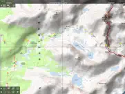
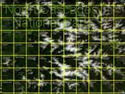
* Locate the maps you need on the satellite view. To install a map, touch for about half a second. Touch again to view it.
* Search by name for over a million towns, peaks, lakes, parks and other features.
* No network connection is needed once the maps have been installed.
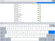
* Mark waypoints, and import and export waypoint files in GPX, KML and CSV formats.
* Touch the "current location" button to see where you are, and the compass button to align the map with the ground.
* See coordinates in NAD27 or WGS84 degrees, degrees minutes and seconds, UTM, or MGRS formats.
* Measure distances (miles, feet and km) and bearings (true and magnetic).
Coverage: this app makes available more than 70,000 maps covering the United States, including Alaska, Hawaii, Puerto Rico and the U.S. Virgin Islands, and Canada.
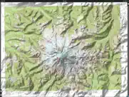
The Maps: This app uses high-quality scans of the traditional USGS and NRCan topographic maps which have been the definitive resource for hikers and other backcountry users for many years. You can make the terrain stand out with hill shading, using simulated sunlight from the direction of your choice. This app does not use the new "US Topo" maps because they do not show hiking trails and lack other details: please see the web site for more details.
Downloading: US maps are around 8 MB in size and download in a few seconds on a typical home broadband connection. Canadian maps are larger. Both cellular data and WiFi can be used, though WiFi is likely to be more reliable in most cases.
- Do please visit http://topomapsapp.com/ for complete instructions, so that you don't miss any features.
We have many ideas for additional features to add to future versions of this app; if you have ideas or other questions or comments, contact details can be found on the website, http://topomapsapp.com/. The website also has more screenshots and other information.
😍 Do you love Topo Maps for iPad app? Please share your friends!

Please wait! Topo Maps for iPad app comments loading...
Topo Maps for iPad 1.19 Tips, Tricks, Cheats and Rules
What do you think of the Topo Maps for iPad app? Can you share your complaints, experiences, or thoughts about the application with Mappendix Limited and other users?
Topo Maps for iPad 1.19 Apps Screenshots & Images
Topo Maps for iPad iphone, ipad, apple watch and apple tv screenshot images, pictures.
| Language | English |
| Price | $7.99 |
| Adult Rating | 17+ years and older |
| Current Version | 1.19 |
| Play Store | com.topomapsapp.ipad |
| Compatibility | iOS 13.0 or later |
Topo Maps for iPad (Versiyon 1.19) Install & Download
The application Topo Maps for iPad was published in the category Navigation on 24 April 2010, Saturday and was developed by Mappendix Limited [Developer ID: 298854054]. This program file size is 112.23 MB. This app has been rated by 14 users and has a rating of 4.2 out of 5. Topo Maps for iPad - Navigation app posted on 18 April 2023, Tuesday current version is 1.19 and works well on iOS 13.0 and higher versions. Google Play ID: com.topomapsapp.ipad. Languages supported by the app:
EN Download & Install Now!| App Name | Score | Comments | Price |
| UK Map Reviews | 3.4 | 5 | $6.99 |
| 3D Map New Zealand Reviews | 1 | No comment | $5.99 |
| Topo Maps Reviews | 4.2 | 121 | $7.99 |
This is a minor update to fix bugs.
| App Name | Released |
| KakaoMap - Korea No.1 Map | 27 February 2009 |
| A-Way WeGo | 28 November 2021 |
| Find my Phone, Friends - iMapp | 26 July 2014 |
| Spoten Phone Location Tracker | 06 December 2018 |
| ParkMobile - Find Parking | 04 April 2010 |
Find on this site the customer service details of Topo Maps for iPad. Besides contact details, the page also offers a brief overview of the digital toy company.
| App Name | Released |
| Spyglass | 04 October 2009 |
| NZ Topo50 North Island | 19 February 2013 |
| MapOut | 19 March 2012 |
| NavRules | 07 March 2011 |
| Cachly - Geocaching | 11 December 2015 |
Discover how specific cryptocurrencies work — and get a bit of each crypto to try out for yourself. Coinbase is the easiest place to buy and sell cryptocurrency. Sign up and get started today.
| App Name | Released |
| X | 09 October 2009 |
| Google Maps | 12 December 2012 |
| DoorDash - Food Delivery | 10 October 2013 |
| CapCut - Video Editor | 14 April 2020 |
| Duolingo - Language Lessons | 13 November 2012 |
Looking for comprehensive training in Google Analytics 4? We've compiled the top paid and free GA4 courses available in 2024.
| App Name | Released |
| Bloons TD 6 | 14 June 2018 |
| FL Studio Mobile | 21 June 2011 |
| Purple Place - Classic Games | 17 May 2019 |
| Geometry Dash | 13 August 2013 |
| Bloons TD 5 | 15 November 2012 |
Each capsule is packed with pure, high-potency nootropic nutrients. No pointless additives. Just 100% natural brainpower. Third-party tested and validated by the Clean Label Project.
Adsterra is the most preferred ad network for those looking for an alternative to AdSense. Adsterra is the ideal choice for new sites with low daily traffic. In order to advertise on the site in Adsterra, like other ad networks, a certain traffic limit, domain age, etc. is required. There are no strict rules.
The easy, affordable way to create your professional portfolio website, store, blog & client galleries. No coding needed. Try free now.
Topo Maps for iPad Comments & Reviews 2024
We transfer money over €4 billion every month. We enable individual and business accounts to save 4 million Euros on bank transfer fees. Want to send free money abroad or transfer money abroad for free? Free international money transfer!
Fantastic Topos. I downloaded this yesterday, so take this as a wee bit preliminary, but this is a fantastic program. It downloads USGS sections with beautiful clarity, much clearer than ones available online. It also allows you to add waypoints. Maps load fairly quickly and reliably over wifi, haven't tried using 3G yet. If you are within a sectional that you've already downloaded, it will locate and track you within that sectional. If you download multiple, adjacent sectionals, the program will stitch them together into one continuous map, although it doesn't seem to retain this stitching when you exit and then re-enter the program. Those who complained earlier about outdated sectionals, well, that's not the developer's bad, it's the government database. But nothing beats these USGS sections when planning a hike or a climb - the elevation, trail, water, and vegetation data are good, just not the urban data, such as what the buildings are streets are (Google maps arguably works better in urban settings). Fantastic app: for $8, you get any sectional for anywhere, anytime.
A nice mapping program. Reasonable program but has it's limits. My main use would be for offline mapping with no internet support so I wanted a program with nice map/waypoint downloading capabilities. Picking download areas is bit fuzzy since the underlying map is not easily seen through the quad grid. Need better algorithm to seamlessly put the maps together in a mosaic. Downloading map quad works OK. Can input user waypoint easily. A bit pricey for what you get.
Very Good. As someone who has used USGS maps professionally for the past 40 years, all I can say is I wish this app and its accompanying technology were available long ago. I have this on my iPod, but because of the small screen, it's kind of a pain to use. On the iPad or iPad mini, it's better than having the actual paper map in my opinion. Of course, if you go to the official USGS store, you can get the new orthoimage-based maps, but they cost $15 per quadrant. If you are comfortable using traditional USGS maps, this is a much, much better deal. In fact if you could get all the quadrants available here for under $8 total at the USGS store in orthoimage format (which you can't because they don't all exist), it would cost you over a million dollars!
Crashes and maps disappearing / THE FIX !. Talked to the developer and he claims that even if your maps crash and your pins disappear, your waypoints should still be in your waypoints list. So i'm guessing if you download your maps again, the pins will reappear? UPDATE: There is a setting in your phone or ipad in settings/ topo maps that allows you to TURN ON backing up maps. The apps default setting is OFF ! This is why everyones maps are crashing!
Brilliant! Wonderful execution of true USGS map viewer. 1st off: For those reviewers who are dropping stars on this app for it using "old" maps do not understand the basics of USGS maps. Some quad maps are just "old" that is a function of funding and/or photo checking of quads and no significant changes having occurred. That being said this program is an awesome implementation of a tool for accessing real USGS maps with an interface that fully utilizes the logic and power of the iPad. If you are a USGS map fan, you will truly appreciate this app. I have worked with USGS maps since the 80's and this application is a realization of so much of what you always thought you should be able to do with accessing and viewing USGS maps. I am excited to see how the developer chooses to grow this app. As I said in the subject, Brilliant!
What’s not to like?. Are you kidding me people? Just thinking about this app makes me excited. No kidding! I have been using topo maps for 30 years and this app has changed my life, for the better. There is nothing about this app that doesn’t work, “just right”. Power, speed, function, native offline use, features that will meet any need you can expect (and more!). Excellent manual, great support, a real work of art in a world of online 4G required apps and dizzying oddness in iPad mapping. Keep up the great work!
Very Well Done!!!!. Thus far this is the best Topo App that I have seen on any apple mobile device...It does exactly what it claims and seems to be very stable. I had only one issue thus far, and a simple reset solved the problem. Customer Service was prompt and answered my query within 24hrs. of sending an email. I have a few wishes... 1. I would like to see more icons, and I would like to see an icon set look a little less cartoonish 2. I would like a simpiler way to download tracks onto the device I look very forward to all of the future upgrades.
A couple features would be a big upgrade. This app has operated great and I recommend it. However, if I could display tracks files the app would be more valuable and I would rate higher. The maps don't show all the hiking trails and 4-wheel trails, so loading tracks files would be very useful for navigation. I'm going to still rely on a highlighted paper map or manually drop waypoints. Another useful feature would be a gps bread crumb trail recorder.
Typos. This is a great app! Put your 8 bucks on the line and download all the topos you can eat! With my home wifi I download a quad in less than one minute. And then it's on my IPad to look at any time anywhere. What 's not to like? I could buy 2000 topos at $9 apiece to cover New Mexico and then not have the ones I need with me when I need it. I tend to roam the countryside and 7.5 miles can go by pretty fast at 70mph.
Excruciatingly Accurate. I Am 52, and have been navigating terrain in Louisiana where I grew up hunting' as well as in Texas, France, Belgium, Germany, greece, and, now.....in the Sierra Nevada mountains of California where I reside. This map is so accurate that I have used it to help train a Fresno County Sheriff's Posse member on cross country horse rides in the Kaiser Wilderness and Dinkey Lakes Wilderness areas. He thought I was joking until Phil Endecott's Topo app, led us down a NEARLY NON EXISTANT trail directly to Ersheim lake. Same posse member had his gps lose ground to this app, which brought us directly to a NO NAME lake in Kaiser Wilderness while his gps was telling us to go another direction. I will always carry a compass and map, but this app has earned my respect, and I truly enjoy being able to use long forgotten trails that this app shows to me. As for why this map matches up so well with the gps? I do not know why? But it does. Thank you Phil, George Dugal Jr.
Outstanding. A superb app for those needing 7.5" USGS maps. The resolution is impressive, navigation within the app and between maps is simple, and there are a number of additional tools such as distance calculation, estimated vistas, waypoints, map stitching, and more. I can't think of anything missing from this app, except a feature to carry my pack for me.
Beautiful interface and maps. I’ve been using The iPhone version for years. The iPad version has the same functionality, but the added screen size transforms this app into a work of art.
Caution Hikers!. This app does provide you with topological maps as advertised and it does so fairly well. My reason for only three stars is that the app description misleadingly says "great for hikers". It is great for experienced hikers who just need a topological map, however, NOT for the casual hikers who expected to see hiking trails on these maps. There are very few visible on them, at least here in the Seattle area. If that's the reason why you wish to purchase it (it was mine), my recommendation is don't. If you just need topological maps of your area, then go ahead.
It. This app is great for the maps, and while the scans of some of the sheets weren't the best, they were still very good. My criticism with the app is the accuracy of the location tool. It invariably was off for latitude and longitude compared to desktop applications of USGS topographic maps, and consistently off by up to +/- 300 ft for elevations in mountainous areas, even when centered on a contour line or a known point or marker. And while this isn't critical if the accuracy isn't important, it is when accuracy is important for work when you need the tool.
real USGS quads!. Yeah, this is what I've been waiting for! Topo Maps for iPad has full-resolution quads (the real USGS 24K maps with collars, not from Terraserver), and it can stitch them together when you run off the edge. Simple map management, both low- and high-resolution versions of each quad, elevation shading and coloring options, all tied together with a clean user interface. The iPad's big screen really makes a difference. I've been using some iPhone topo apps that look OK at 2X, but -WOW- this made-for-iPad app really shines! You can save on disk space by loading low-res maps for looking at gross details, then download the high-res map where or when you need it. Done with the high-res map? Click a button and it instantly downgrades to the low-res version to save space (or erase it entirely). The high-res maps are the real deal: print-quality copies of the USGS DRG TIFF originals; no JPEG artifacts here! The "iPad Screenshots" above don't do these maps justice. The pictures there are mostly high level, and lots of products look good like that. But if you're planning a cross-country hike, you want to zoom right in to see the same dots as on a printed topo--and, with this app, you can! If you want real topo maps, this is the app for that.
Five star and worth it, especially for Scouts. Can I say planning camps, hikes, overnight camping spots has just become amazingly easy with this app. Waypoints are simple, linking into Google Earth from the app to look at an area or specific spot is invaluable. I can evaluate a trail, look at the contours, measure distance, and do some quick and easy advanced planning. Just wish there was an easy way to print the maps with the scale and other markings on them!
Best app I’ve ever purchased. This may be an oldie but I wanted to stop in and say it’s the best purchase I’ve ever made on the App Store. With a gps enabled iPad it effectively turns your iPad into a full screen topo map with location. Get the maps you think you’ll need at home and no need for cell signal. Super powerful tool for any type of outdoor activity off the grid. Just want to say “Well done” to the creators.
Best Offline Topo app. If you need a lot of detailed topo maps and where you're going may not have cellphone signal, this is the best app to have, in my opinion. I've been an avid user for years. If I could change a couple of things, I would have a more detailed overview map, a way to turn off the grid and downloaded tile highlights while looking at the overview, a comment field for waypoints (instead of having to type it all in the name), and an easy way to upload/download map tiles from the app to my computer and back again. Yes, some of the maps are old, but I haven't had many problems with this because country areas don't change much. This app in combination with the public lands app "Maplet" is unbeatable for off the grid trekking. I will say though, when this app came out there was virtually no competition, but the competition has increased and they are getting better while this app really hasn't changed a lot since its release. If the offline functionality is eclipsed by an app with a better overview and offline map management, I would switch.
Good program. The program loaded well and has many excellent features. The topo maps are from the 80's so be aware of this if attempting to use them with a hand held compass (e.g. declination diagram no longer valid). I also noted that the elevations posted on the maps may not coincide with what the program says the elevation for a particular grid coordinate is. However, this is a trivial issue if you only want to use these for GPS navigation on foot. Excellent work!
TopoMaps verses iTopoMaps. I am a long time user of Topo Maps but I wanted to try something that had more color in their maps so I downloaded iTopoMaps. I found that iTopoMaps constantly redrew as I moved the map center and just was not worth the wait. Also with iTopo, I never was able to down load a map section in Quinico. Finally map down loads were much slower in iTopo. By changing the view options, I was able to get almost as good a view as iTopo. finally it is a small thing but I kind of like the little waypoint icons of TopoMaps If TopoMaps reads this, please consider adding a option to added connecting lines between waypoints labeled with "crow flies" distance. Lance Stairs
All topo maps at your fingertips - wow. Not only does this app give you an incredible database of topo maps, but the features for dealing with them are super. One suggestion: maybe some maps could be re-scanned. Some seem to have been scanned slightly crooked, preventing effective stitching of adjacent maps. For example, near N45 W90 (Athens, Wisconsin and vicinity). Still, great app.
Useful and non-annoying. App authors always seem to want to squeeze more money out of us. Ads on paid apps... paid extra add-ons, you know how it goes. This app has none of that. You want big, full-resolution maps of the entire USA? Sure! You want low res maps to conserve space? They have that too. Want to see what's around you on Open StreetMaps? Done. See where you are with the built in GPS? OK, done. All in all a nicely done app that does its job well.
Better than I first thought. This app is well worth the money! There is still the opportunity for refinement/improvement (After reading the updates pages I found you can download up to 10 quadrants, should be in the instructions and the instructions are hard to read on the iPad) Navigation, when you leave topo view to look at terrain or, road maps etc. the only way I can figure to get back to topo view is to exit the program and relaunch. The icons which are only available on the topo view seem a little cryptic. I also seem to have some bookmarks that only appear in certain views? Seems like you add bookmarks/waypoints differently in different views. A great addition would be something like the state gazetteer maps that show campgrounds and back roads. With a small bit more work it could definitely be a 5 star. I'd happily pay more for some extra features. I could envision additions, could even be paid add-ons.. Overlays for Different types of campgrounds (NF, BLM, SF, etc.) Could be a great RV'ers application for finding RV camp sites. Overlays that can show different types of land features.
Great App. I have both the iPad and iPhone versions. This app is not super intuitive so read the directions. There are lots of hidden capabilities. For example, in the map download screen tap and hold a map until it turns blue then drag to select multiple maps. Also, I had a problem and sent the developer an email, I had a response within 24 hours. Great app, worth the money.
Economical Solid choice for topo Maps. I've used this app for about a year and I have to say I've been pretty pleased with it. It's somewhat basic, but it does what I need it to, offline map storage is requirement for me and it meets that criteria easily. I wish is supported a few more features like different layers such as aerial or street, track recording, and elevation profile generation, but for the price it's hard to beat and I will continue to use it.
Great tool!. This app is great. I was using an online topo map download for an annual subscription price with relatively low on screen resolution and small viewing size. As an avid rockhound and backcountry explorer, I use this app all the time. The GPS interface and measurement tools are wonderful. I also like the fact that you can now place adjoining maps together and scroll around them. This saves me a lot of printing or buying topo maps. I just pick the area I will be working, download it into the app, and pull up the maps I need when I arrive in the area. The only drawback at all is the age of some of the USGS maps but they are still quite useful.
Grate app!. Does a very good job at being an intermediate/advanced navigation tool. Well worth the price for the maps alone! The added tools make it an even better value. These older maps are good as they show what was once there rather than what is there now, good way to find forgotten or overgrown roads and trails. They can be a pain when a road that should have been good to drive is now gone. As with any tool knowing the limitations is critical. Always have a back-up plan and people back home who know your plan and route. Thanks for the superb outdoor tool!
Greatest topo app. This is the best topographical map app you can get! The cost alone is cheaper than buying one usgs topo map from the store and you can download all of them, yes that's right all of them for no extra charge. The great thing too is that you can zoom all the way in as well and they hold up (great resolution). It also has a shaded relief view which is really helpful to give you an overall idea of the land when you are zoomed out. The previous reviewer only gave it 3 stars as it seems they are not familiar with the usgs 7.5 minute topographical maps (not topological as they called them). If the maps are missing a newer trail that is not on the usgs topo map that is because the usgs hasn't updated it. I can see this as being a problem but if you buy a usgs topo map from the store it will be the same thing. This is not the app developers fault. If you can read a map and use usgs maps then this is the best app out there that you can get!
Fantastic. This program WORKS! I purchased this and when to Yosemite. I found trails I didn't know were there. The ability to locate were you are on the map is FANTASTIC. No one should ever get lost using this program. You can read it in the dark, which make it easy to follow a trail at night. Every hunter, back packer, photographer should have an iPad with this program. You can place where you car is and then always find it in wildness. By only turning the iPad on when you need directions this program should be useful for days.
Any Topo map you need… with amazingly useful tools!. I can't say enough about this App. Imagine having access to any Topo when you want/need it, along with sophisticated measuring tools, GPS coordinates, elevations and waypoints. If you hike or bike or ride anywhere outdoors you really owe it to yourself to buy this App. It's WELL worth the 8 bucks! The only downside is that the USGS Topo maps are seldom up-to-date but that's not the fault of the App. It least your far better off in the wild with such a Topo map than no map at all.
A great app for USGS topo maps. I've played around a bit and I like this app. The fact you can seamlessly join together maps is a big plus. And then today I found that I could e-mail a zipped 15x15 scale usgs map to myself and open it,this app astounding. Now I can have some of the usgs historical maps in the I-pad. I hope they don't upgrade the maps to the latest ones available.
Excellent App for Hikers. The map data is the same data you'll get with the USGS quadrants, and also includes visual topographical information. I love that the maps are readable zoomed in or out, and the zoomed-in detail is highly legible. The associated map tools are also useful (mark waypoints, measure distance, etc.). This app beats "iTopoMaps" by far. I've used "iTopoMaps" as well, and the map data was pixelated/grainy and extremely difficult to read or even be useful. The only thing I'd like to see added to this app (why I gave it 4 instead of 5 stars) is the ability to mark complete trails instead of just waypoints. It would also be nice to have a means to sync data from GPS devices.
I love this app!. I usually don't give comments on apps, but this one is exceptional. Being able to carry topos of several states and provinces wherever I go is pretty awesome. Being able to look at a particular point on a topo, then look at he same place in aerial view is even better! Just to balance out all the praise, I wish you weren't limited to 20 high-res topos at once. It'd also be nice if you could do custom pins. That's all nit-picking, though, because it's the best topo app out there.
My favorite iPad app. It's been my favorite iPhone app for some time and as expected it's even better on the iPad's larger screen. The program is responsive on the iPhone, but of course it's even faster on the iPad. Just like the iPhone version, downloading USGS quads is easy and convenient and the maps look great. Also, the developer has been very responsive to suggestions. Buy it.
Technically good, but outdated maps -- Update. UPDATE: The developer contacted me and explained that USGS has updated maps on some servers, but not on the server he uses to access the GEOTiff formatted maps that the program uses. He is working with them to solve the issue or find a workaround. Kudos to the developer for being responsible. If the maps get updated, I would rate this program much higher. I am keeping my fingers crossed. ORIGINAL REVIEW: I think the program is OK as far as the software goes, but the maps are scanned versions of fairly outdated paper maps. Thus, you run the risk of not having roads or trails that exist on the ground not being on the map or, worse, roads and trails that once existed but were closed or moved not being shown on the map. Had I known that the app used outdated maps, I would not have purchased it. As it is I am stuck with it. If up-to-date maps are important to you, look elsewhere.
Just what I was looking for. This is great app, just what I was looking for. I have started to do some off roading and wanted to be able to use my iPad and not my pc for the maps. I have the wifi only version, so I needed a off network app. I tried another topo maps app that you had to have yearly or month subscription but was pain to get maps on to the iPad. And when I needed to work it did not. The plus side to this app is you can DL maps from with the app. I give it only four stars because wish the app could track were you have been. I can't seem to find away to do that. Would be nice update if the app does not have it now.
I love this app.. Just got back from a fishing trip in the middle of nowhere. This app got me there and back. The fact you don't need Internet access to view downloaded maps makes it useful,the fact it can find your location with no service makes it the most useful app I own. Would recommend it to anyone.
Best map app ever!. If you ever liked playing with topo maps, this app is a must! GREAT features allow you to measure distance and compass heading between points. Awesome feature allows you to see the view-shed from any point - fantastic for real estate analysis. I bought my mountain property based on this app. Perfect balance between government provided maps and beautiful 3rd party software that makes this one of my all time favorite apps!
Buy itopomaps for better quality maps. I now own 3 of the topo maps apps on the AppStore, and while this app has some nice features and interesting integration... It has a clunky method for downloading and activating maps, and the maps don't have enough zoom levels nor are the scans in color. I want to be able to zoom in on the scans till I can count the pixels! Why can't any developer get it? I would like one of the map app designers to realize that nobody wants to grab quads one at a time. Why can't I select an area by highlighting the 4 corners of the box on the guide map and let the app automatically batch download all the quads within that box? Or better yet, download a whole state at a time. I have 64gb of storage why would I not want to grab a big section of maps so I don't have to use cellular later to get others I missed. Import and export of waypoint datasets is awesome, a feature that ITopoMaps does not have! That being said, it's all about the maps themselves, and ITopoMaps has better, color scans of the topo quads so I'm staying with them. Wish I had my money back on this one :(
Excellent App. This app combined with a bluetooth Bad Elf GPS Pro works perfect on my wireless only iPad. An always on option would be helpful because it currently requires the user to go to settings and change the Apple display auto-lock setting to never, which I seem to forget to do before I open this app, then of course you have to remember to change the setting back once you stop using the app. All in all though this app is highly recommended for back-country driving in areas with no cellular/wifi service, as long as you have a GPS and have already downloaded your topo maps or offline maps. I use the same app on my phone as my primary backup (and hard copy maps as a second back-up). I do use Avenza Maps too as it offers more map options, especially for kayaking but my primary back-country vehicle navigation app is this one.
Just OK. Pros: 1. Easy to figure out the interface. 2. Downloads seemed quick over 3G & Wifi 3. Cheaper than other apps that allow downloadable maps and/or subscriptions. 4. Easy to manage downloaded maps. Cons: 1. Super low res grid map is useless when trying to identify a map to download by geographic detail. Way too blurry. Thankfully you can turn on city itentification to help you figure out where you are. 2. As other users have indicated, the USGS maps can be ancient. I KNOW this isn't the dev's fault, but maybe alternate sources should be made available. Both the Cabela's app and Backpacker app have much nicer maps. Granted both are also more than 3x more expensive. Guess you get what you pay for. Ok, so one could argue that even tho topo are 30 years old, the maps shouldn't change that much because the geography shouldn't change that much. But other references on it do change, and I wouldn't want to be "out there" without current references. Ultimately I think I'll pay the extra for the better maps. I still have hope for this one though.
Very good app. This is a very useful app and works better than the other topo apps out there. People: don't be stupid in your comments and ratings of this app. It uses official USGS topo maps. Some of them are very old, yes even to 1972 and older. This is NOT THE APP MAKERS FAULT. Did you think one guy makes all these maps? Likewise if you don't see all of your hiking trails marked. Again, they're government maps and not always up to date, but they are great for giving you topographic features of the landscape. Feel free to complain to the USGS for having old maps but remember they're the best we have. I can't believe some of the ignorant, uninformed comments being made.
Solid and usable. I've used it for several years both iPhone and iPad versions. I have looked for something that might be as useful as the old topo maps but haven't found anything that isn't an expensive commercial solution like ESRI or the like. This is a very usable way to take lots of maps with you into the field. I have tried Gaia but I haven't had good luck with the download integrity. This apps download routine may not be the easiest, but you do have what what you somewhat tediously selected.
Buy it if you are familiar with usgs quad maps. I remember buying quads for $4 each. This program has the whole US for $8. Awesome deal. Maps are clear on the highres setting. You must download maps prior to using them. Only fault is that the pindrops dont show the name unless you touch them.
Essential. I won't go out in the woods without a topo map and a compass. With this app on my iPad or iPhone I have both. (I still carry the paper maps and a real compass for backup — I'm not going to completely trust my safety to electronics — but this is what I actually use.) With the GPS turned on, this is perfect for bush whacking, and I've used it that way on several hikes. (One warning — the information on many topos is 50 or more years old. I've found myself trying to follow old trails and roads that are on the topo I'm using, but that simply don't exist on the ground — not even a trace!) It isn't the prettiest app I own, and the interface is kind of quirky, but for its purpose, it's almost perfect, and if you use topo maps, it's pretty much indispensable. And, as another reviewer noted, it will pay for itself by the time you've downloaded your second map. Incidentally, it works equally well on the iPad and the iPhone. An iPad is obviously better for looking at a whole map, but the iPhone is a lot easier to carry in your pocket or your hand, and works just fine when you're actually finding your way around.
Great for finding the little things. Uses the older topo maps which, in many cases, have more detail than the newer maps. If you want the most detail in your maps, this is the app. Works well in the field without an Internet connection because the maps are downloaded directly to your iPad beforehand. Great for exploring all the little things they have left off the new maps.
Great topo app.. The maps are high resolution and look fantastic on the new iPad. This app does a good job of rescaling the maps as you zoom in or out to keep them looking crisp. The app is straightforward to use and allows seamless (more or less) stitching of maps. I give it 4/5 stars only because the app stutters a little when you drag the maps around to reposition them. This is probably a limitation of iPad horsepower so I maybe am a little harsh but it is a little distracting.
Best topo map app for iPad!. I've tried a bunch of mapping apps for the iPad, but this one stands out as the best by far! I highly recommend reading the built in help once you download it to see all that it's capable of. High points: 1. USGS topo maps with low res and high res versions available for each region. 2. Easy to browse around the world to find regions you would like to download topo maps for, then download multiple regions simultaneously. 3. Color coding to show which regions you've downloaded high or low res maps for. 4. Maps are saved on your iPad for use in areas without Internet access. 5. Ability to seamlessly stitch maps together. 6. Waypoints. 7. Distance/direction calculator. 8. Search which actually works! 9. Display your iPad's current location on the map. Basically, this app is awesome! I've already spent hours playing with it getting ready for a trip to the southwest.
It works! USGS maps on your iPad.. I've been using this for a few days and it works great. Finally a solution for downloading and using FREE US Geological Survey quadrangle maps! It does a great job locating my position on the map using GPS. Marking waypoints is easy. I love the feature that shows visibility in variable terrain from your location. It is very flexible with ability to take bearings and define distance to a target location. A great app! It will even stitch together USGS maps into a larger map. Very nice app and well worth the money.
Back to 1970. Really not impressed. The maps are severely antiquated and not very useful for hiking at all. Compared to other options, this was thrown together to garner a profit before the developer is found out.
Did you know that you can earn 25 USD from our site just by registering? Get $25 for free by joining Payoneer!
Imagine you at your best. All the time. Picture yourself at your sharpest and most productive. Your most alert and focused. Your most lucid, creative and confident. At work. At play. In every area of your life. Add Mind Lab Pro® v4.0 to your daily routine and uncap your true potential. Buy Now!
Topomaps. Excellent program. Downloads hi-res top maps for any area in North America. GPS enabled iPad also finds position on maps. Impressive program for the price.
App used to be good. Not working on iPad Air iOS 8. App used to be really good. However on iPad Air running iOS 8 touch and hold gesture is too sensitive causing the app to think drag gesture is being performed. This renders app useless as it relies on tap and hold gesture to download maps and to switch between overview and Topo maps. Hopefully this problem will be fixed in a future update.
"The App!". If this was the only app available for an IPad..., it would be worth buying an IPad. Outstanding!
Don’t waste your $$$. Unfortunately this app uses severely outdated maps which isn’t helpful when you are navigating in the backcountry and need current information. Search for a better app!!! Apple needs to do their due-diligence when allowing app developers to put their apps on the Apple apps store to ensure the apps do as they claim.
What about Newfoundland. Downloaded this app and no maps for Newfoundland so it is completely useless for me.
Topo maps. This is a great app. Using it on ipad os4. Looked at all of them and settled on this one and am glad I did. Very easy to use, comes with a neat help file. Downloads are easily done. This is well thought out software. I tip my hat to the makers of it. I have several actual topo maps now and for the price you pay for this software its a steal and you get the downloaded maps free. Sweet
excellent. excellent app... once you have paid for the app, just start to download for free any maps that you need .... works well, displays the maps brilliantly, and you can join adjacent maps together to move seamlessly from one map to another ... well worth the cost of the app
I WANT A REFUND. Please give me a refund. It does not cover all of Canada.
Very Good. I have had an opportunity to use this application extensively during the past few weeks. It does exactly what it is supposed to do -- to provide access to good quality topological maps. The maps are searchable and easy to navigate. I really cannot think of anything negative to say about it. The scale of the Canadian maps (1:50,000) is sufficient for most purposes. I do not know if other users of mapping applications have had occasion to use land survey coordinates, such as those used by the Dominion Land Survey for Canada, and the similar system used in the USA. My only wish would have been to see this application, or even a stand-alone one, that would convert correctly such coordinates to latitude-longitude or UTM.
The map is not very good. As topographic map, I expect I can easily tell the elevation. The map only has elevation value for major contour lines. I found I need carefully count several neibouring lines to determine the elevation of current location. Full digital map instead of scanned map would be nice.
Unclear. Paid the full price expecting it to work for the iPad. Unfortunately (the first time) I didn't see that the version I downloaded was for the iPhone and paid the 8$. I then downloaded the "correct" version for iPad and had to pay ANOTHER 8$. There was no way on the website to get a refund for my errors. I'm still pissed that it wasn't easy to differentiate between the 2 versions. That said, there are better topo programs out there for a lot less money. Don't buy!
Awesome App!. I would have to say this is by far the best!!! Great Price, I have tones of maps downloaded and available for offline use, tones of way points set and it runs flawlessly!! Quick friendly support!! Keep up the good work!! Highly Recommended!! Thanks!
Incredible app. If you need topo maps this the app. You can merge adjacent maps and zoom in on the area you need. Spend the $8. You then get all of the topo's of Canada and USA for free. Well worth it.
Not worth it, Canada. These maps are only scans of paper maps. Most of the maps I downloaded are crooked. The map borders/edges are visible and no ability to have two maps viewed together so viewing those areas requires you to go in and out of one map to another. Very cumbersome. NOT worth the cost. For what they charge, we deserve better.
Only my second choice for Canadian maps. This could be the number one topo map app for Canadian topographic maps, if it would render the map joining better. Unfortunately I happen to live in an area where four maps join and that causes thick lines and margin text to clutter the map. Topographic Maps Canada handles this perfectly smooth, with no joints visible, so I think it should be possible to fix this. It would also be appreciated if it supported the Toporama Maps, which are in color and revised. It would be a great feature to zoom out of a map and get to the next wider scale from 1:50,000 to 1:250,000 for the Canada maps. If you are on a river trip the 1:250,000 are the standard map to use. There needs to be a download option for the 1:250,000 maps. Waypoints: nice selection of waypoints, but most of them are obstructing too much of the map. There could be a tiny default diamond or lozenge for quick placement without opening the Add Waypoint page. Tracking: It obviously has no tracking feature, which is a drawback in my opinion. The distance tool behaves sluggish on the iPad 3, with map tiles blanking out when the map is moved. This is also the case when moving the map. "Compute what's visible" is an interesting feature and handy to have if you are trying to identify landmarks. I recommend the app but it can't replace my laptop app (MacGPS Pro) for navigation, and that's unfortunate.
Ripoff. Bad purchase, uses old scanned Canadian Topp maps that are outdated, wast of money
Amazing!. If I could buy it twice I would. Fantastic app for plotting your next adventure! Server function allows you to easily import waypoints and tracks from apps on your computer like Garmin Basecamp.
Fonctionne très bien!. Simple et répond à mes attentes.
Worth every penny. I am very happy with this. It has provided me with exactly what I was looking for.
Adsterra is the most preferred ad network for those looking for an alternative to AdSense. Adsterra is the ideal choice for new sites with low daily traffic. In order to advertise on the site in Adsterra, like other ad networks, a certain traffic limit, domain age, etc. is required. There are no strict rules. Sign up!
Whoops !. Was having problems downloading maps so I contacted Phil , he really came through for me . The App. Is working great now .
Developer is a Cheapskate!. Main Entry: cheap·skate Pronunciation: \ˈchēp-ˌskāt\ Function: noun Date: 1896 : a miserly or stingy person; especially : one who tries to avoid paying a fair share of costs or expenses! While everyone else in this community has embraced multi iDevice ownership, this dev apparently doesn't get it! Sure, this app is great, however its unfortunate the dev has decided to "grind" every last penny from his/her users. If you purchase this app, you can only use it on the type of iDevice you purchased it on; i.e: I payed $7.99 for the iPad version and if I want to put this app on my iPhone, I have to spend an additional $7.99 for the same frickin' app?!?! WTF? I will not be supporting this dev in the future. If the dev happens to read this: Get with it bro...no one wants to buy the same app twice!
Great app. If you want access to topo maps but don't want to carry them, this is the app for you. Make sure you download the maps you'll need in advance and have a way to recharge your iPad in the wilderness, I.e. Solar.
Great app. Its the best function to value topo mapping solution period. Great job Phil!!
Excellent resolution. The USGS maps are outdated and don't show all the trails but that isn't the developers fault. At least in California this app works great! It is good enough for backpack trip planning but also refer to the USFS maps for campgrounds and better trail info.
Why 17+?. The topo maps are fine. Why is the app rated for 17 and older?
Great. It's like having every USGS map at you fingertips, well at least the ones I need for the southeast. The scans are great and on wifi the high resolution map downloads are pretty fast.
Excellent app!. The best app managing topo sheets!
Awesome. After less than 2 minutes using this app it was looking at the quads map for my location, which had previously taken hours og googling to find (ok, slight exaggeration on the hours, but not the 2 minutes). Very very impressive.
USGS Maps. Not sure why this app gets such low ratings. Where else can you get official USGS topographical maps - the same exact maps you would spend a considerable amount of money to buy in the paper form. And you can download them to view offline. You can even download adjoining USGS maps to display seamlessly both north-south and east - west just by scrolling. A simple "tab" in the lower right hand corner takes you to an overview of the entire continent and it clearly shows you which USGS maps you have downloaded. Now you could download map by map an entire state or continent for that matter. But that might be too iPad memory intensive. I have however, downloaded dozens of select USGS regions I am particularly interested in. The app works just fine with an external Bluetooth GPS receiver (the GNS) since I only have an iPad with Wifi. So what's not to like? Now the maps you download don't seem quite as pretty or as graphically as smooth as the ones shown at the app store but they are USGS maps. I know because our company keeps drawers full of the exact same maps for the entire state of Oregon. The maps can be downloaded in high resolution but realize that the maps are scans, so complaints about the "look" need to be tempered. Now the map graphic enhancements in settings such as "shading" etc. don't really enhance that much in my view. But one has to realize that the more topographic features that are present the better the map look. A USGS map is not designed for presenting pretty images of streets and roads in cities with flattened topography. And yes, there are other mapping apps that are perhaps prettier. But you know what? They are probably based on the original USGS maps that are presented here. A USGS map is about topographic detail not finding your way to a Starbucks. So if I want to be "star" stingy I guess I could subtract one for the graphic enhancements in settings. But in a way that's not quite fair because the app delivers in providing actual USGS maps within a relatively fluid interface. You just tab to the overview, press and hold on a map you have previously downloaded and it opens. The app has other useful features like a " button" that provides a circular mileage and degrees overlay. With your finger you can rotate the degrees to indicate direction of travel or just to see what the declination might be with respect to geographic north. While I may not be taking the iPad directly into the field (archaeology) it certainly travels in the car and I prefer these maps to any others for the orientation detail. They are the industry standard for many professions.
The best App if you want USGS topos maps!. I've been using this Ap for over a year (both iPod and iPad versions) with a BadElf external GPS and it works great! There's no need for a cellular connection once you've downloaded the quads you want. Most recently, it saved my butt while exploring a remote, roadless area of Utah, far from cell service. Those who complain in the Ap reviews about the age/quality of the maps obviously have no prior experience with USGS raster topos. If you understand the limitations and advantages of those, this is the best tool I've found for using the large scale USGS quads on an affordable mobile platform. My thanks to the developer for a very useful program.
Still the best topo app out there (update). Perfect on my iPad Mini! I really appreciate the ability to sync maps between my iPhone and iPad. 1.15 has worked flawlessly for me. Stable, flexible, fast, responsive, and well-designed. Of all of the apps I've tried or bought, this one stands head and shoulders above the rest. I love the ability to either import or export waypoints, and to share maps between my iPhone and iPad instead of needing to re-download everything.
Mixed feelings. Maybe it's just me not understanding how to use this app, but as to now I'm not finding it useful to find the spots need. I'm not giving it a bad review, it just doesn't do what Im looking for. The maps app simply does a better job. It's not worth $8 to me but free would be more worth the download:)
Getting outdated. I got this app a while ago and used it occasionally. The problem is it relies on the old topo maps which are hard to read. US Forest service maps are way better. I am trying to find those now.
Fantastic App. I have been using this app on both an iPhone 4 and iPad for over a year now. I have downloaded about 4000 topo maps, 16 gigs worth. I use it when exploring huge areas on my ATV here in Idaho. Plus I downloaded 25 maps for a hog hunt in California and another 50 or so for a fishing trip to Oregon. If I read about a place that sounds like I might want to explore it I download the relevant maps and check it out. I have retired my Garmins. This app has better maps and is easier to use with better displays. It is also extremely accurate and fast. To cover a single 20 mile loop could take over 50 paper maps. No problem with this app. I use the zoom in and out feature constantly as well as the waypoint and search feature. I also use the map elevation to calibrate my Garmin GPS wrist watch frequently. I use the distance ruler occasionally as well as different units capability (UTM and Lat/Long). I rarely use the other features. I usually just want to see the blue dot where I am standing and the names of the surrounding features and the waypoint marking camp. My only caveats are: some of the underlying maps are outdated - obviously not the fault of the app. Moving waypoint files between devices is a pain. And downloading a maximum of 20 maps at a time is a minor inconvenience. The program occasionally hangs when I launch it. I haven't figured out if this is a communication problem with the Apple GPS code or a bug it the app. A force abort of the app and a relaunch fixes it so it is a minor annoyance. All in all this is in my top three most used and enjoyed app. If you have a GPS equipped Apple device and spend time outdoors, especially off the beaten track, this app is spectacular. Update: Dec 2017 I continue to use this app extensively and love it. Over the years the app has been improved in important ways. For example I just upgraded to iPhoneX from my old iPhone6. Apples iTunes save/restore failed to work properly. Fortunately I had backed up my extensive waypoint files using that feature of this app. I had to manually reload all the topo Maps into the iPhoneX, but was able to reload all the waypoints from the back up file effortlessly. This is really great real world functional app.
Great for Off Road Exploring. We do some off-road exploring and camping with 4x4 vehicles in the Northwest (mostly Oregon and Washington). My traveling friends have a heavy duty laptop PC mounted in their truck, connected to a GPS, with mapping software. Hoping that I could substitute my 3G/WiFi iPad for the PCs, I purchased this software. It just plain WORKS! I downloaded and installed all, and I mean ALL, of the high resolution maps for Oregon and Washington at no charge. While this has consumed quite a bit of storage on the iPad, the results are very, very good. With the maps installed, we headed off into the heavily wooded Gifford-Pinchot National Forest to test the iPad and Topo Maps for IPad. The iPad GPS worked just as well as my backup Garmin eTrex Legend H in terms of finding position, and the application on the iPad seems to deliver most of the functionality of what my friends are getting on their PCs, withe a lot less bulk (in terms of equipment). As we were checking this application, we referred to other paper maps from time to time, and soon developed complete confidence in the apps and the maps provided. The only feature I find lacking at this point is a tracking feature, where the app would automatically store positions as you moved along, so that you could later review them as a track. The best features of the app are the ability to download useful maps for free, and the "stitching" feature that connects maps is excellent. This app is easy to use, reliable (no problems getting to their server(s), no app crashes), and inexpensive.
awful. 5 crashes in 5 minutes of using the app. Really? The waypoint management is atrocious, but a great way to blow up the app. $8 wasted. :(
Old maps. Topo Maps is a pretty good program BUT you have to be able to put up with very old (circa 1972) USGS maps (for instance the Hidden Peak quadrangle of Utah. Disappointing!
ancient_1. If you like and can use topo maps this is an excellent program especially if you have an usb gps so the program reads your location. The one I have by Dual works fine with this program on the 1st generation ipad. Without the gps capability it is not nearly as useful.
Topo Maps for Ipad. I checked out several mapping apps for the Ipad and this is by far the best for my needs. I take people on scenic flights and need to identify numerous geographic features and also do some aerial fire detection and other survey work. The download utility is great, it's easy to use and it's easy to locate the proper areas to download. Having the ability to download 20 maps at a time is a huge asset. I've downloaded the Idaho panhandle and Lincoln Co. in NW Montana, about 200 maps, plus a few Canadian maps and it works excellently. The waypoint marking feature and the suggested list of names based on nearby geographic features is outstanding. Particularly when trying to name multiple things in the same drainage (give the first one a name plus a number and the next number will pop up in the list with the same name). I also really like the ability to stitch topos together just by pressing the blue arrow, or if you don't want to, just wait till the blue dot (you) progresses beyond the edge of the map and the next map will pop into view. It's also easy to un-stitch the maps if you need to read the Township & Range markings or other info on the edge of the map. I'm very pleased with the app and it works fine in my airplane. There is one feature I'd like to see added. It would be really nice to have an on-screen button that toggles a lock for the other on-screen buttons so that inadvertent touches wouldn't change the screen but would still allow the gps location to function. Kudos to Phil Endecott for a great app.
Great program but!. I really like the topo for iPad program. However, it is real cheap of the developer to require you to buy both the iPad and iPhone program. Wake up fix this oversight. Or, was is intentional to squeeze us dry?
Good but not finished. Great app, good maps, download what you need, great memory saver. But screen print and email is the only option for printing. Add air print or email full file then app would be five stars. Also w Also watch the maps they are not all current.
iPad version does not work. I have used the iPhone version, and it is fine, except of course the screen is too small. The mosaic function on the iPad version, which is essential to using the topo versions of the maps, does not work. The iPhone version works better on the iPad than the iPad version.
Togo map. I like that you can download section and not need Internet to look at it. But when you go to the big map I would like to see roads and city's.
Good, but. Good: - stitching of map is very nice - simple to use - doesn't get in the way of good map reading Bad: - old maps, can't chose newer sources - no way to mass delete map tiles - no maps of non US / Canada locations I found this app incredibly helpful - really indispensable - in the Sierra. However it's pretty darn useless in PA and I'm deleting it to save space for movies before I go to Spain.
Great App!. This is the best bargain out there. I started using this app while hunting areas w/o cell service. Being able to download both USGS maps and satellite images for the areas ahead of time allows access to this data while offline.
Junk. I find this the biggest waste of money for any app I have ever bought. The only reason I give it one star is because I could not give it zero. The user interface is hard to use. I was hoping to use this as a navigation aid on a hunting trip I am planning. The last thing I want is to be on a mountain in Colorado with this app as my means from getting lost. I think I will stick to a paper map and compass.
Great App. I been using this app quite a bit, especially when flying around. It has made it very easy to flight follow along. Definitely worth the 8.00 bucks I paid for it
No longer works. I don't know if it is the new update for iOS 8 I am still using iOS 7. This app no longer does anything when opened and I can't zoom in to view maps at all.
HORRIBLE. I have had the worst time downloading maps, keeps timing out and no customer service. this app straight out is worthless!! i give it no stars. if there was support to help and figured out if i am doing something wrong, which i doubt, i will retract my rating.
Fantastic. This really is a great app. It seems like this is the kind of stuff that iPad was made for! Keep up the great work!
Excellent app!. I don't write many reviews. But I really do think this is an excellent app. We are full time 4x4 RVer's. We wilderness pack back in the summer and do volunteer work for the Forest Service in the winter. We prefer to disperse camp (boondocking) instead of staying in camp ground or RV parks. This app is great for all of the things we enjoy doing. I save waypoints of where we camp so we can go back to them again later. I don't carry my iPad with me hiking and packing but I use this app for reference while at base camp. Love the way it splices the maps together!
Topo charts. Charts in most cases are very Very old. Appears not to be up to date. Way over priced.
Very disappointing!. Poor user interface, blurry maps, not worth the money.
Only for iPad. Dumb me, I thought like with most apps I could get this and put on my iPhone as well. Smart developer who made one for both devices so you have to buy it twice, once for each device. Great app, I would give it a five star, but wanted it for the phone. Oh well, the developer is now $8 richer so I can put it on both devices.
Well executed. Got what I paid for. Smooth zooming. Easy downloading of the maps you want. High or low rez. Import/export of way-points via easy to use in app GUI. Looking forward to the development of tracks use. Plus all the extras .... obviously well planned out and executed Keep up the good work
Fun to use. Great app for all geospatial iPad people
Excellent App!. No complaints. Crystal clear image, accurate, no issues. An essential tool for the backpacker, hiker, hunter, fisherman, or whatever else gets you into the wilderness. The quads even have most hot springs labeled.
Needs work but still an ok app.. For the money this should be better. It needs: The base map has almost no detail. This makes it hard to find the topo that I really want to download and I have to guess and check with what I download. I would like to know the actual file sizes before I download. Just saying large or small tells me absolutely noting at all. I would like to go from one map to an adjacent map without going back to the base map. This is a good solid app but needs to be better.