Maplets – The Offline Maps App App Reviews
Maplets – The Offline Maps App App Description & Overview
What is maplets – the offline maps app app? • Maplets is the most comprehensive offline map app on the app store, with over 2 million map downloads by our users! •
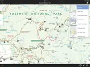
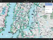
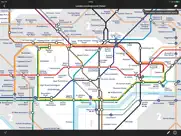
• More than 10,000 maps in the US and worldwide including Yosemite, New York Subway, London Tube, Yellowstone, Grand Canyon, State Parks, and more. •
Maplets is the perfect compliment to Google Maps: You can download and store maps of national parks, state parks, metro, subway, bike maps, ski resorts, college campuses, zoos, theme parks and more! In addition, this is an iPhone and iPad universal app so there's no need to purchase the app separately for all your devices.
You do not need to purchase the more specific maplets apps such as Bike Maps or Metro Maps if you already own the full version. Maplets has access to the entire database of maps.
Please visit http://www.mobilemaplets.com/places to see a list of all available maps. Here are some examples:
P R E S S
—————
▶ Selected by WIRED App Guide as one of the “Outstanding Apps” in the Productivity category and rated it “Buy It Now”
▶ Featured by Apple in 'Apps for the Great Outdoors' and one of the Staff Favourites
NATIONAL and STATE PARKS:
——————————————
1000+ National and State Parks, including:
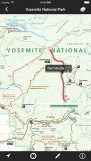
• Yosemite National Park
• Yellowstone National Park
• Grand Canyon National Park
... in fact, ALL the US National Parks, National Monuments, National Seashores are available
• State Parks in every state
• Local parks such as Central Park, Prospect Park, Griffith Park …
METRO and TRANSIT MAPS:
——————————————
300+ Metro, Subway, Bus and Train system maps
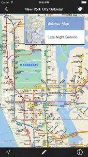
• New York City Subway
• London Tube Map
• Paris Metro
• San Francisco Muni
• Washington Metro
• MARTA
• SEPTA
… and many more!
BIKE TRAILS MAPS:
——————————————
500+ maps for bike routes, rail trails, ATV, OHV or snowmobiling, including:
• Los Angeles Bike Map
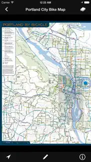
• Portland Bike Maps
• St Louis Bike Map
• Washington DC Bike Map
• Many rail trail maps
• Even Bike Maps in UK and other countries
… and much more!
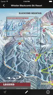
And then there are SKI RESORTS, UNIVERSITY CAMPUSES, ZOOS, THEME PARKS … There are just too many maps to list!
F E A T U R E S
———————
• Add notes to any map:
– Add a pin to mark a meeting point, draw a line to measure a distance or add a path sketch a route
- Share your notes with friends or export for backup
– Undo/redo and editing capabilities
• Every map download is free, with a continually updated source of maps.
• High Resolution and Fast – Much faster than viewing the equivalent PDFs on iPhones and iPads
• Once maps are downloaded, they are stored on the device for quick access even if you have slow or no internet connection at the location.
• GPS location for supported maps (see website for complete list). Please note that there's no turn-by-turn navigation feature at this point
• Organize your maps into folders
• Notification of new map updates
• Hotlinks to get up-to-date information such as weather, snow report. Requires live internet connection.
S U P P O R T
———————
If you'd like to see a park or place near you use Maplets, feel free to suggest it to us and we'll do our best to add it. Map requests are subject to availability of the particular map.
If you are an institution wishing to publish your map on our system, please contact us at accounts@mobilemaplets.com
For reporting bug, missing map information or feedback, please visit:
http://www.mobilemaplets.com/support
😍 Do you love Maplets – The Offline Maps App app? Please share your friends!

Please wait! Maplets – The Offline Maps App app comments loading...
Maplets – The Offline Maps App 3.9.1 Tips, Tricks, Cheats and Rules
What do you think of the Maplets – The Offline Maps App app? Can you share your complaints, experiences, or thoughts about the application with Zaia Design and other users?
Maplets – The Offline Maps App 3.9.1 Apps Screenshots & Images
Maplets – The Offline Maps App iphone, ipad, apple watch and apple tv screenshot images, pictures.
| Language | English |
| Price | $2.99 |
| Adult Rating | 4+ years and older |
| Current Version | 3.9.1 |
| Play Store | com.zaiadesign.maplets |
| Compatibility | iOS 9.3 or later |
Maplets – The Offline Maps App (Versiyon 3.9.1) Install & Download
The application Maplets – The Offline Maps App was published in the category Travel on 10 December 2009, Thursday and was developed by Zaia Design [Developer ID: 337841742]. This program file size is 19.68 MB. This app has been rated by 1,234 users and has a rating of 4.4 out of 5. Maplets – The Offline Maps App - Travel app posted on 30 May 2018, Wednesday current version is 3.9.1 and works well on iOS 9.3 and higher versions. Google Play ID: com.zaiadesign.maplets. Languages supported by the app:
EN Download & Install Now!| App Name | Score | Comments | Price |
This app has been updated by Apple to display the Apple Watch app icon. • iPhone X fixes
| App Name | Released |
| Google Earth | 27 October 2008 |
| My Disney Experience | 02 August 2012 |
| Vrbo Vacation Rentals | 19 July 2017 |
| Enterprise Rent-A-Car | 03 October 2015 |
| Airbnb | 10 November 2010 |
Find on this site the customer service details of Maplets – The Offline Maps App. Besides contact details, the page also offers a brief overview of the digital toy company.
| App Name | Released |
| Joshua Tree Offline Guide | 17 August 2022 |
| GPS Transportation Wizard WDW | 20 February 2012 |
| OpenADSB | 19 January 2018 |
| PackPoint Premium Packing List | 06 January 2015 |
| Sakura Navi - Forecast in 2024 | 09 January 2024 |
Discover how specific cryptocurrencies work — and get a bit of each crypto to try out for yourself. Coinbase is the easiest place to buy and sell cryptocurrency. Sign up and get started today.
| App Name | Released |
| ChatGPT | 18 May 2023 |
| Amazon Prime Video | 31 July 2012 |
| PayPal - Send, Shop, Manage | 03 February 2019 |
| BigFuture School | 28 September 2023 |
| Telegram Messenger | 14 August 2013 |
Looking for comprehensive training in Google Analytics 4? We've compiled the top paid and free GA4 courses available in 2024.
| App Name | Released |
| Incredibox | 27 March 2016 |
| AnkiMobile Flashcards | 26 May 2010 |
| Arcadia - Watch Retro Games | 18 December 2019 |
| Ultimate Custom Night | 28 April 2020 |
| Purple Place - Classic Games | 17 May 2019 |
Each capsule is packed with pure, high-potency nootropic nutrients. No pointless additives. Just 100% natural brainpower. Third-party tested and validated by the Clean Label Project.
Adsterra is the most preferred ad network for those looking for an alternative to AdSense. Adsterra is the ideal choice for new sites with low daily traffic. In order to advertise on the site in Adsterra, like other ad networks, a certain traffic limit, domain age, etc. is required. There are no strict rules.
The easy, affordable way to create your professional portfolio website, store, blog & client galleries. No coding needed. Try free now.
Maplets – The Offline Maps App Comments & Reviews 2024
We transfer money over €4 billion every month. We enable individual and business accounts to save 4 million Euros on bank transfer fees. Want to send free money abroad or transfer money abroad for free? Free international money transfer!
Using Maplets on all hikes. Outstanding app. Just works, exactly as you would expect. Been using for four years. Not all maps are available. You can ask that they try to add missing maps, but it might take a while.
Great app; so sad no longer supported. Been using this across many parks for many years. Really great. But now no longer being updated, so sad to see that maps are becoming slowly out of date. Will keep using until too dated, because the other apps are nothing like as good as this one
Very simple; very useful!. At times, the marker runs slightly off the trail/road you're physically on, but not so much you can't easily recognize where you are. Other than that, this is an extremely useful app because if you lose cellular signal, you still have the map in front of you to use; unlike most GPS apps—lose signal, lose the map.
No Back Button Due To iOS Update. I absolutely adore this app and have used it for more than a decade. Recently it stopped working on my phone because the back button which would allow you to go to a different maplet no longer works. You can tap it forever but it won’t let you leave the current map. So now I’m stuck in one map and if I want to see another I must delete the app, download it again, and then download whichever map I want to use. :-( Please please please can we have an update for this 5-star app? I’ll be getting a new phone later this year and I’m optimistic that might solve the problem. If so, I’ll be sure to update this review.
Awesome!!. This is so useful! I'm so happy to have the Marin Bike Map on my phone now in a format that is more useful than a big image. Additionally, the app is fun for fantasy travel ... I'm not sure when I'll be in Joshua tree, but it's fun to look at the map. New features that would be nice are in app purchases of non-free maps like the Krebs Cycle touring maps or mtn biking maps (I'd happily pay $9 for the digital version). Great app!!!
Extremely happy with this app!. We ride the Hatfield McCoy trails in WV and KY, which has more trails than any system I’ve been to. This app is great for navigating tight and twisting offroad trails. Before this app, we used the paper map, which worked, but it was a 5 minute discussion about where we were and which way to go. I recommend this app to anyone we see in the trails or asks for directions.
Is this app still active?. It still works for the maps I have but I can no longer add new maps. Message says “cannot reach server” or something like that. Facebook page and feedback links are dead. Unfortunately when my last phone ran out of storage I deleted maps that I would desperately like to have back. This is the best offline maps app I’ve used for dirt bike trips. I’d gladly pay a monthly or annual subscription in order to get it back. Please take my money.
A great aid for trip planning. We have been using Maplet since our first iPad. The ability to get instant complete information that can be used on the tablet or e-mailed is wonderful. The application is extremely easy to use and very reliable. This is one of the best applications on our iPad.
A super app, no doubt about it. Before we head out on another road trip somewhere, I look for whatever info/maps are in this app and download. Thus, I have my hands on NP maps, say, to plan before we drive up to the Park toll booth which provides the paper map. Just on example. No reason not to have this app for your future adventures!
Best map app!. This is by far the best map app out there! I use it primarily for parks and campgrounds/trails but they also have city maps, subways, bike trails, etc. This app is well worth the money! Download the map you think you'll need if you aren't going to have any cell service and it's very helpful. Works for both iPhone and iPad. Same program, no need to purchase again as some apps have you do (separate program structure I think sometimes..) but this is not the case. No way to sync between the two devices but that's okay. Highly recommend this purchase!
Luv this app. I bought this years ago-and every year it has been one of my favorite apps. I use it for hiking in parks and for international travel. Say I want to find a map of bicycle routes in a foreign city- this is my go to place.
Very useful tool!. Simple. Download the parks you plan to visit. You now have the park map on your phone. While you’re there, GPS will locate your current location on the map with a blue dot. Brilliant. Just used it in Lassen NP where cell service is virtually non existent. I was able to keep track of my location on roads and trails while in the park.
One of my favorite apps... and it’s free!. I use this very regularly when I go out hiking, especially in new areas or when I’m looking for a new trail to explore in a park I already know. The geo referencing that shows where we are on the trail (or even for just finding the trailhead while still in the car) is invaluable. And there’s no need to keep track of scores of paper maps. I’ve recommended to many friends.
The best app.. I have long been searching for a map app like this. I have never found it until I found this one. I recently went to many national parks and was able to download the maps for them and access them offline. This app can even locate you on the map using gps. It is absolutely great. I am glad it's free, but I would pay for it.
Truly Amazing. I have found (and used) maps for everything from the small state park near my house to Yosemite. The app integrates these detailed, to scale maps with my iPhone's (and iPad's) GPS. It provides useful navigation where apple and google don't have useful maps, and where AT&T has no coverage. Love it! I do wish I could zoom in more when drawing on maps. (They are PDFs, after all.)
Very useful for hiking. I have been using Mapkets for a couple of years to stay on track when hiking in unfamiliar territory. One thing I have noticed is that on occasion I am not tracking along the marked trail but parallel to it or even further afield, which is disconcerting if you don't see any other visible path. Maybe some of the maps need updating? Overall, though, this is the best app I have used for trail hikes. Thumbs up.
Maplets Server Permanently Down?. This is literally my most favorite app. I’ve been using it as my go-to hiking map for years. But, recently (2022), its server (where all of the maps come from) appears to be down. You can still use existing maps you already have. But you can no longer get new ones or update your existing ones.
One of the best apps I’ve ever used. I love maps. I also love hiking and off-roading at parks and forests. So it’s no wonder that I love Maplets. The single best feature it offers, in my humble opinion, is giving us users the ability to track (via our phone’s gps) where we are on a highly detailed pdf map. The first time I saw that on my phone, I was blown away, and I still am. It’s just a beautiful and useful tool for exploring beautiful, remote places.
This app saved us. Glad to have downloaded this app before a recent hike. I already knew the trails were very poorly marked but Maplets worked like a charm with its GPS voodoo. We covered a moderate 6 mile trail and Maplets kept us from getting crazy lost. I would give 10 stars but they won’t let me. Bravo.
Ok map app. This app is okay but didn't work great for when I tried to use it to navigate while off roading. The fact that the map is stuck in true north position limits this app. There are other map apps available that automatically orient the map using the iPhone's compass. I have my iPhone in a holder while I'm driving so I can't rotate the phone to orientate the map, so the fact that the app won't even let you rotate the map manually on the screen makes it even less useful.
Maplets is great, very responsive. I love Maplets I've been using it for years. I use it for planning for inspiration and even on-site out in the field. I find it especially useful to see you what's near me by distance. It also decreases the amount of paper I need to use. It is totally convenient to have it on all of my devices. Out of all the the hundreds of apps I have, I use this is one a lot, it is one of my very favorites.
Must have app!. I used this for the first time last weekend on a off road riding trip in southern Kentucky. The actual trail markers left a bit to be desired and there were a lot of trails not on the official map downloaded into Maplets. The GPS feature was used several times to verify our position which was extremely helpful!
Outstanding!. Outstanding App! Extremely useful, don't know how I ever lived without it. Unfortunately as of this date (August 24, 2022) maps can’t be searched. It says “Cannot find server. Please check that you’re connected to the internet.” The app hasn’t been updated in 4 years so perhaps it’s no longer supported. Great app though when it works.
Great app!. I’ve used Maplets for years—it’s a super app. Straightforward, easy to use & incredibly useful source of all those little local maps that are so handy to have around. Especially love that I can download them for use offline—how often have you gone for a nice walk in a state, city or regional park and found you dropped the paper map, forgot to pick it up or glanced at the trailhead sign & thought, “I’ve got this”? Except then you get down the trail and no, you don’t. Left or right? GPS locator info for many of the maps is icing on the cake. Thanks, app developers for years of help!
This app has become indispensable. Ever since I found this app, I don't know what I did without it. Perfectly focused and simple execution and design. Reliable and good coverage. I hope this never goes away. One request: please add the ability to sort Maplets by distance, so I can quickly find the ones that are closest to me.
Didn't want to pay a subscription for Gaia or All Trails. Just used Maplets today on a 20 mile hike up San Gorgonio. This app is worth every penny of the 2.99. I'd be happy if I'd paid 10 dollars. You buy the app and you can download FREE maps from the app that work with your phone's GPS. Maybe it doesn't have all the bells and whistles of some other apps, but it works when you're out in the mountains and you don't have to pay some stupid subscription to get maps. I'm not trying to map my route for Instagram. I want to not get lost. Also, the draw feature works well to estimate how far you have left to go.
Incredibly useful. We travel to places that are often offline, and Maplets is an essential tool. I have access to maps that are on my device when I need them.
Great app. I have used this app all over the US for hiking, mountain biking and urban exploring. It has been fantastic- no bugs or glitches after a few years of use. Plenty of gps enabled maps are available for everything from some fairly unpopular small state parks to zoos, malls and national parks.
So Useful and well done!. Great map selection across the USA. Many maps are GPS enabled. So you can find your location on the map you downloaded before you set out -- even when you have no cell signal while hiking in a remote spot. Some maps are enabled with a nifty Search and Find feature for easily locating landmarks and special interest features. The app automatically downloads most current versions of your maps when you select the Update option. Maps can be sorted and organized into folders as you see fit. Great app at a great value!
Wonderful app, problems in iOS 16. I have used this app for years and love it, but as of today on iOS 16, the “back” button doesn’t seem to be working, to switch between maps. Once you’ve opened a map, the only way to get back to the listing of maps is to hit the ℹ️ button and then delete the map you’re looking at. So the app is still technically usable, but it’s sadly clunky now.
Great when it works. Lately I get a constant message that I’m not connected to the Internet one in fact I am. This makes downloading new maps impossible so I’m stuck with the handful that I currently have and I am unable to add anymore. It also looks like this app has not been updated in several years so maybe it has been abandoned?
Great App. My family and I ride ATV's. Another rider showed me this app last year, now I don't ride without it. Throw those paper maps away, being able to locate yourself on the map with GIS ability is just awesome! Wish I had found this app sooner. Give it a try, you won't be disappointed!
Best offline solution yet!. Plan ahead! Search for a map before going, download it and you'll be good to go! I have used Maplets in Europe and the U.S. In Prague I had my phone on airplane mode to avoid paying for incoming calls and texts, and the app worked great. I was able to track my location in Old Town Prague and determine how to get to different places no problem. Then in the White Mountains of New Hampshire there was zero signal but I was able to stick to the correct trails as I did the Presidential Traverse because my location was constantly mapped. Very satisfied user and I was singing Maplet's praises to fellow hikers!
Best app for travel. Seeing exactly where you are on the map is great. Only we as users can make it better by contributing maps and making donations. This is the first ap I check when headed to a new area when headed into the back country or a national park.
Great way to have special maps offline. I’ve been using this now for many years and it is still a mainstay. How many apps is that true of? One of the drawbacks of nearly all the online maps on iOS devices is the absence of specialty maps. These are things like nature trail maps, campus maps, terminal maps, etc. where the usual suspects simply don't provide the desired information. This app let's you trivially find such maps near a location and download them for use offline (out of cell range or where you don't want to pay cell charges). Even better, many of the maps will show you your location with a 3G device's GPS. Better yet, if you have maps, you can add them to the collection available-no begging for a map necessary. The interface is pretty clean and straightforward. And you aren’t staring at fees per map either unlike the only real competitor in this niche. The only drawback is that to add a map, you have to match the Google Mercator projection-not an issue for small areas but troublesome if you want to post something larger. The interface for georeferencing a map is clever though a tad challenging for some map styles.
Don't leave home without it!. It is to the point now that when I do multi-day backcountry trips in a national or state park, Maplets is my primary navigation tool. I know that sounds crazy, but it's true. Took a three day trip along the White Rim Road in Canyonlands Natl. Park last week, and never needed anything else, and that's just the most recent example. Very accurate, very reliable, very easy. Download your map while on wifi or a cell network, then put your phone on airplane mode, then hike using Maplets.
Long-time favorite hiking app. Maplets is simple and let’s you know where you are when you get a bit lost. Ability to drop pin was a lifesaver when I had to leave my partner in the dark in the woods to hike out to get rescue. Led rescue team to exact spot. Best thing is that unlike most feature heavy apps, this one is easy on your battery. Excellent.
Great app!. I love this app, and often use it when walking or hiking. The maps are usually the official maps for the trail system, and can show where I am on the map, using my iPhone GPS. I can find maps for most trails in my area. I also like that, if a map isn't available in this app, and I send them a link to the map on the internet, they will add it to Maplets.
Best mapping software out there. This thing is so handy. Just do yourself a favor...download it now. My husband maps our local bike trails for Orienteering and biking and he can upload georectified PDFs they have a blue dot that shows exactly where you are on the trails as you are moving. Used it in Europe and found Swiss hiking trails and the Rome subway maps. Awesome app
Great for trail runners!. I rarely take the time to write reviews, but I have to for this one. Maplets is extremely simple to use, and simply does what you actually need when you're out on a trail trying to navigate. I've found almost every park I go to has an available map. As someone who hosts public trail runs, this app is proving invaluable.
Excellent app even in the base version. Incredibly useful and simple. The amount of information presented in easy to understand formats is amazing. And, it does it all in under 20MB of space. Just shopping for places to go nearby is fun and eye opening for the number of places you didn’t know you had available.
This app should be on everyone's smart device!. Anyone that ever leaves their home should have Maplets on their iPad and iPhone. Don't think about it, just do it! So many great maps to choose from: Walt Disney World, Disneyland, all kinds of colleges and universities, baseball stadiums, historic and national parks, California missions, zoos, bike trails, museums, botanical gardens, observatories, offline city and state maps. Some maps, like those for colleges even have a gps feature so you know where you're at if visiting the campus for the first time. Best map app ever! And if they don't have the map you're looking for, you can request it and they'll let you know when it's ready to view.
Fantastic App!. This is a great app that just keeps getting better all the time. I am an avid hiker and lead a local hiking group. I use this app at least twice a week, and have used it to track my progress on a week long backpack in the Sierras. It is loaded with maps of every variety – not just trail maps. It contains airport maps, transit maps, bike routes, you name it. Last year in Hungary I discovered that it had the bus and transit systems for Budapest! Recently I needed a trail map for a local watershed that was not in their catalog. I made a request and they added the maps in a few days. I have found them very responsive. If you can find the map you want as a PDF on the web, they can add it for you, and most are GPS aware and will plot your location. Great app.
Great hiking app!. This is my “go to” app for hikes! I can see exactly where I am on the map and what direction I am facing. As noted in other reviews, it does not track my course, but I use AllTrails for that. What Maplets has done superbly for years is to allow me to quickly see on a map where I am - which I can use to decide what fork in the trail to take or how to get back to the trailhead or a desired location.
Outdated maps. When I purchased this app several years ago, many of the maps were up-to-date. Now, in 2023, most of the maps are way out of date. Plus, world cities have random, inaccurate tourist and transit maps. This content app has a deep need to be refreshed, esp. in light of changes due to the Covid pandemic.
Super useful. To be able to see your position on the state map is very helpful. Sadly these aren’t very large or detailed but it certainly helps with general positioning. I wish we could overlay these onto a satellite or detailed topo and change transparency like in Gaia maps. Nonetheless great tool.
Fantastic app!. Wonderful app for travelers, hikers and just about anyone on the go. This is a very helpful app. I particularly like the GPS feature that keeps you from getting lost in unfamiliar locations as well as the folder function to help you categorize your downloaded maps. I use this frequently for hiking as well as recently traveling through Europe.
Excellent Resource when traveling - world wide. I have used this excellent resource frequently over the years. Before I head to a destination, I see what maps are out there for that destination. This app has original maps that people upload. Based on looking over these maps, in the past, I have been able to find gems that locals know about, but travelers may not. Also, very handy to be able to download the maps locally
One incredibly useful app!. This is my favorite trail app. I've used it for many years. It has a huge number of maps available and you can always request new ones for areas they don't yet have. The maps don't hog excessive space on your phone. Nearly all of the maps have gps enabled to allow you to identify exactly where you are on the map - no more need to wonder which way to turn at a trail junction.
Great app for trails. I’ve used this Maplets for several years. It is my favorite trail app, but they also offer other maps such as zoos. The two things that I really like about it are: 1. I vaccfownload the maps and use them anytime. Sometimes I do need to download them again, so I will check before I go to hike some place to make sure I have the map on the app. 2. If I do have cell service when using the a map on the app, my location shows up on the map on the app. Today I was hiking at a park that I had not been too for awhile, and the trails weren’t well marked. However, I was able to find where I was on the trail, and that gave me a lot of peace of mind on my hike.
Did you know that you can earn 25 USD from our site just by registering? Get $25 for free by joining Payoneer!
????. Complete and utter shyte. The maps are photos of brochures. If you just want simple maps, fine. But I saw gps compatability in the write-up and it falls drastically short
Brilliant but Needs more Non-USA maps.. I really like this app. It's a good idea well done. I was a little disappointed with the relative paucity of Australian Maps, I get the impression the same applies to a lot of places outside North America. I hope they can get at least the national parks of other countries up soon and I will try to get time to contribute maps. Though the instructions I could access left a lot to be desired. BUT at $2.99 I think it's a great effort and if maplets can develop an "End-User Community" that actively upload then I think this can go far!
Fabulous app to plan a journey. Love using the various maps to drop pins onto possible destinations, draw potential routes and write notes about points of interest. I will use this for dreaming and planning not for managing a detailed travel itinerary or spot-on navigation although the estimated distances on the paths is great. Would love it if the notes section could hold URL links.
A great resource for traveling. Have used extensively around the world and found it great. Offline gps location means you always know where you are. Recommended.
Maplets rules!. Thank you for this app. Have just downloaded all the maps I need for Paris Italy and Spain. Great value
Quite Impressed!. If the developers keep updating their database of maps this will be my go to map repository. I'm very impressed. Good work.
Waste of money and Maps were last updated in 2014. Bought this expecting to have up to date maps that I could use offline whilst I travel, however the maps I needed were last updated in 2014, beyond useless. I went the extra mile to contact support. No response from App Support. Waste of money!! Wish I could give it "0" (as in zero) stars. How do I get my money back?
Exactly what we needed. The ability to see my current location on the many cycle maps available from the dept of transport here in little old Perth Australia while on my bike is invaluable. Thanks heaps Maplets!
Slow, antiquated. Desperately needs updating , slow to open , even slower to use.
Excellent app. Easy to use. Convenient and accurate. Well done.
Maplet. Used thus App while we were overseas ... Was fantastic, we planned stuff to see and do b4 we left, and were able to use the iPad in the offline mode to find our way around. The developers need to continue searching out maps etc from all over to make it universally useful anywhere.
Imagine you at your best. All the time. Picture yourself at your sharpest and most productive. Your most alert and focused. Your most lucid, creative and confident. At work. At play. In every area of your life. Add Mind Lab Pro® v4.0 to your daily routine and uncap your true potential. Buy Now!
I'm saying it again!.. Great App!. Just wanted to expand on my previous review. I used to print out and take paper copies of maps and other travel info on road trips. Since getting an iTouch, and more recently an iPad, I'm helping to kill less trees. Some of those maps however, are huge. Even my Core i3 desktop lags when trying to zoom and pan them. Not so with Maplets. Fast, fast, fast! The touch interface also works so much better for viewing maps. You can't add your own maps directly, but have to download then from the Maplets website. That seems to be part of what makes the viewing so fast. Browsing for maps is quite easy and can be accomplished in several ways. The map library seem to be quite large, but if a map isn't available, you can request it. My request was fulfilled in less than 24 hours. All in all, I'm quite happy with Maplets.
No Canada!. It seems you can sell the app to Canadians you just don't know where we are on a map! Total waste of Canadian money!!
Really useful. This is what I really like - an app with some real utility! The maps that I have accessed for my own use have been accurate and correct. A truly useful app. It does what it claims and provide a service that no one else seems to have thought of (without mentioning that big company we're all familiar with). Well worth 5 stars!
Great program!. Tremendous choice of maps.
amazing app!!. I've used the maps to have on hand information when seeing a place for the first time ( and having missed the information center ). The maps are very responsive compared to others I have downloaded. For the most part they are easy to read and have all the points of interest along the route taken. One of my best buys and would recommend it highly.
Passable. A bit clumsy to use and continuously crashes when you try to delete a map and then reloads the just deleted map when you reopen the app, very frustrating
The app forced a 5$ purchase. I never confirmed or even purchased the item. I got an email with the receipt and I was confused. The app forced a purchase itself
Great, useful app. This is a really useful app, when there are maps covering the area you want - and the coverage is rather good for large cities. If you have hard to find map, you can even contribute them through their web site.
Maps maps maps. Awesome. Find what you need. Recommend purchasing, can access any map, anywhere.
Great App. Very detailed and usually up to date.
Great app. So useful
Awesome. I requested hiking biking trail map of whistler B.C an several others an in no time you got them for me . Thanks guy's very much I love this app an use it lots. I have pay as you go iPhone 4 with no contract an your passive GPS Works awesome. Thanks again an please send me any other apps you come out with. Regards Stephen Sawyer
Ouch! Wasted money!. The NW States and Western Canada is poorly covered at best in terms of finding campgrounds. I'm definitely not seeing the wonderful app these other reviewers are going on about. The only thing it is is a fast scrolling highway and city map with an odd and random assortment of local maps. Far from comprehensive and sorely lacking.
Love this app. Still very useful after all this time.
Just Great. I'm so happy I found this app. This can only get better as more maps are added.
Must have when traveling. More maps are now GPS-enabled which makes this app indispensable for traveling; you can put a pin of your hotel onto the map of the city you're visiting and wander around without getting lost - no cellular service or wifi required, just GPS grid on the map and your GPS-enabled mobile device. Not 5/5 because the current version requires 7 taps before you can enter the label when dropping a pin into a map.
Love it!. I love this app. It is helping my son & I enjoy our road trip! Thanks…I will be recommending to friends and family
Really superb app!. Note!!! This app uses pre-existing maps (trail guides, your local zoo's handout, etc), so if your area seems short in maps that you know are out there, get involved and submit requests! Even up here in eastern Canada there were lots of maps already, and shortly after I sent in requests for about 10 other maps they were added. The maps are great resolution, and because they are downloaded onto your device they work when you're out of range - necessary when hiking/mountain biking etc! Very uncomplicated layout, and the ability to add points or draw overtop of the maps is bonus. Highly recommended, one of my favourite apps!
Super. Make a request for 2 maps in Québec, got it 1 week after request.
Very useful and fast. Fast display of all sorts of maps. Simple and reliable. Requests for the addition of new maps were handled quickly by the app authors. Great when maps are georeferenced, however not all of them are.
Great Idea. Works well and gets you access to many different maps!
Fabulous little App!. How else can you carry a complete map of the London Underground, Toronto Zoo, The Toronto Downtown PATH System and still have room for any other map you can think of. It is one of the most useful apps I have on my phone.
Good. Could use more maps near me, but I can't fault the app for that.
Awesome. I highly recommend Maplets for hiking in state and national parks, for visiting university campuses and for using public transport.
Impressive App...even for Canadians!. Pretty decent coverage of the Vancouver, Canada region. Very happy with this purchase. One wish...please provide information about how to contribute and to append GPS data to maps.
Adsterra is the most preferred ad network for those looking for an alternative to AdSense. Adsterra is the ideal choice for new sites with low daily traffic. In order to advertise on the site in Adsterra, like other ad networks, a certain traffic limit, domain age, etc. is required. There are no strict rules. Sign up!
Excellent. Very useful for off road riding! We always take a handheld gps for backup but absolutely love this app. It has most trails we ride and have suggested it to all our friends.
Servers Are Back Online!. I’ve used maplets for years. Great to have geo-referenced offline maps when available. Servers were down for several months but all is well again!
Are you still there?. I don’t seem to be able to add maps any more. Is the app still around?
Useful for local parks but I can’t get common mountains. I use it a lot for a Blue Hills MA map but many times I try to download popular places (like Mt Mansfield in VT) and Maplets does not have it. Not have I been able to request any missing maps as I don’t have url numbers.
Incredibly useful. We travel to places that are often offline, and Maplets is an essential tool. I have access to maps that are on my device when I need them.
Love it - don’t go without.. Makes travel easy. Find the maps you need before you go. Download them and use later anywhere. Great selection of maps.
LOVE IT!. You can download Virtually any map with this app and it pinpoints your position on the map, even without cell service! This is one of my favorite and most useful apps!
LOVE THIS APP! Accurate!. Being able to use GPS in conjunction with the map is huge! It’s accurate every time and I’ve used this in several different OHv area. A+++ guys!
Go to travel app. Great app, I usually use it as an on the fly map app. My wife and I head out on an adventure, we stop for gas or hit the trail headed and I grab a quick map of the area. She's always impressed with my skill, now she asks me to find the maps because I'm so good at it. Thanks
Easy to use. Excellent way to discover new places and simple intuitive GPS navigation. Submit you own maps for even more functionality.
Awesomely. This saved me lots of time and frustration when finding my way around a new installation. It is a must have. Easy to used and very helpful!!!!
Great for approximate location even on airplane mode. Solid design with location accomplished even on battery save mode.
Reliable hiking app. Been using for several years now. Grateful for all the maps and use it often in airplane mode to save battery life. Love the pin feature so I can mark my own points of interest.
Really useful. One of my top used app for a decade now. Really powerful an useful way to navigate at home, on the trail, in new cities. Non-obtrusive, not trying to do more than it should, just a quality app. Thank you.
Great Little Resource. I always look for maps before I head out on my camping trips and this app always seems to have a useful map for the journey.
Love this app!!. This is still my favorite app when hiking and looking up places! To the developer; thanks for doing such a fantastic job! Please keep updating the app!!!
very helpful app highly recommend. wonderful for parks, museums, transit - where people had kindly uploaded “paper” maps for thousands of attractions; many of them are GPS-coded even better!
Too New to Rate. App insisted that I should rate it...have not had enough time to determine Pros/Cons... All I know is that the Watkins Glen State Park map is static, I guess I need to enable the GPS feature in order for this to be live navigation. I need more time to figure it out. Too busy now exploring without this app.
Used to be Amazing. This app is an amazing offline map viewer. The problem is that the app can no longer connect to the servers. So you only have access to maps previously downloaded. The developer and update seems to have stopped around a year ago.
Very useful and delightful. Great for walking about in a tremendous variety of places, from cities to remote campgrounds. Remarkably quick to add a new maplet if you tell them when you find a map anywhere online that’s not already a maplet.
Viewable Maps. Love this app, lots of maps that show you where you are. Also you can add local maps with georeferanceing!!
Snowmobile trip pleaser. Best trail map app I've ever used. Made our trip safer and more fun! Whole family rides now that we always have an up to date map. Makes night riding much more practical!
Great for hiking. I use Maplets every time I hike which is usually at least twice a week. It is very helpful when you’re out in the woods to be able to tell exactly where you are and what trail you are hiking on.
Convenient and easy to use. Maps open quickly and are available when you're offline. Especially handy for parks, museums, and public transit.
Excellent resource. It is so useful. I like the gps feature so you know where you are even without any phone reception (often happens on hikes). Can’t thank you enough for this app and super map options.
App Support Please. Downloaded the app because I heard it was a great way to use maps in areas that there is no cell service. However, after purchasing the app it will not connect. Keeps stating “cannot find server”. I tried using the app support link and received a 504 error. I am unable to get any support. Either I want to get it working or a refund.
An indispensable app. Such a well thought-out and functional off-line map application. Download this app and keep it on your phone! Do it!
Awesome. The app continues to improve. I haven’t used it in a few years so I was surprised when I opened it today and even the bus map had GPS ability. This could be really handy for when the cell signal is weak or slow.
Most useful map app. Trail map with gps, offline. Much better than offline google maps for trails.
Most used app on my phone.. I use this app for everything... Hiking trails, amusement parks, resorts, water trails, campgrounds, recreational areas, etc. If there's a map, it's in this app. If it's not, just request it, & it'll be added within a few days.
My Favorite App For Government & Education Maps. Maplets is the first place I look for PDF maps from government, education, and similar free sources. In my experience, If a map is not available in the app, and is available from the official web site of the agency, park, airport, college, etc., the developer will make it available in the app within 2 or 3 days. Organizing my collection of downloaded maps is easy. Any updates can be applied to all downloaded maps in a single operation. I have nothing but complements.
Indispensable Trail Companion. If you hike, everyone's got their own little map. Keep them all in your iPhone with this app. You can add your own maps. Just find the PDF and sign up to contribute. Many maps also are GPS aligned. Really great app.
Very Good App!!. I have been using this app for a long time and very convenient whenever I travel to other cities. It shows not only the map but also able to obtain related information. Very good apps.
Excellent app. Wow. Well done. I found some of the xy coordinates to be slightly askew but that is probably the person the built the PDF map I was using. This is a great no nonsense app and I am a full on gps snob.
Awesome maps with in Map GPS. It's great to have access to random maps for all over the world. It's really awesome that you can open those maps and orient yourself to know exactly where you are on that map. Really great app, works really well!
Love this for OHV trail riding. This is a great app for trail riding you can find most of the trails in the NW area!! Sometimes they are named differently so if you do a location based search you will find most of them, thanks for this app!!
Accurate & informative. Doesn't need cell towers to locate your position nor load map. Accurate positioning. Clear and informative maps.
Maplets - Great app. I give it 5 stars. You can download a map and even without any reception you can look at your map and see where you are. I highly recommend this app.
You need this App.. Really, you do. Gets better with every update. Every map your heart could possibly desire. Never failed, not once. Not even Apple can say that.
Great App!!!!. Easy to use. Having new maps added is easy and I love the GPS on the maps!!!! Off-line maps have come in handy too!!!
Very useful. I make use of the GPS enabled maps all the time. It's a bit disappointing when there isn't one available for the area that I'm at.
I wish it worked…. I shopped around a bit for an app where I could download maps to use offline. Maplets seemed like a good choice so I bought the app but as soon as I launched it and tried to add a map I got an error message: “Cannot find server”. I haven’t been able to use the app at all, unfortunately.
Won’t download. I can’t get this app to download anything for me. When I first downloaded it, it allowed me to download a Sequoia National park map, but since then it says I don’t have internet and it will not download anything else. Actually would like a refund if this can’t be resolved...
Comes in handy. A little hard to use sometimes, but it helps ya when you figure out the right layer to get on if you have a map with multiple layers.
Vacation Planner. Thanks to Maplets, I've been able to better plan our family vacations to the National Parks. Being able to download them all in one place on my phone has been invaluable.
Good, might become great. I have used this on a limited basis, and I like it. Seems to squander less power and cellular data than other apps of its kind. I just wish more detailed maps were available. The more I use it, though, the more helpful it seems to become.
Fantastic App - Well Done. This app has finally taken state park maps and adopted them for the smartphone. Tried out Afton State Park in Minnesota this weekend and it worked perfectly. Thanks for bringing these maps to the phone.
Great App!. I wish all off-road parks would have upload their park maps with trails on it so you can get around easier using this app!
Awesome App for Hiking. So many maps available and the added GPS is very helpful. No need to cross your fingers and hope there is a paper copy of a trail map on site. Now you can check this app before you make the drive.
Wonderful. This is a great app. Every map I have used has been accurate. It doesn’t use much power. When I hit a fork in the trail, I take it out and take the right path - every time.