EasyTrails GPS App Reviews
EasyTrails GPS App Description & Overview
What is easytrails gps app? EasyTrails GPS is the GPS tracker application for your iPhone.
The perfect application for those who are passionate about OUTDOOR ACTIVITIES and TRAVELING, everybody who likes outdoor sports, and not only.
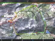
Are you going for a bike or motorcycle ride? Well, EasyTrails GPS will tell you how many miles you traveled, how much time you spent, how high you climbed and many other details. In real-time it will show you the course on a map, comparing it with downloaded tracks and points of interest.
You can import or share all tracks and waypoints, photos and ideas for new journeys with your friends.
Share where you are on Facebook and Twitter through your GPS position, and export your tracks in standard formats, so you can review them on Google Earth, SportTracks and TrailsRunner. Or simply upload them to online services like Garmin Connect, or many others.
It's possible to import tracks by e-mail or Safari (EasyTrails can handle GPX, KML/KMZ and ZIP file formats), or by wi-fi networks, using an improved and easy to use web-based sharing feature.
Calculate routes and let EasyTrails guide you using the new navigation capabilities. You can also let it guide you through previously recorded tracks.
Additionally, EasyTrails GPS can communicate with navigators like Maps, Google Maps, TomTom or Waze (if installed) for more advanced guidance needs.
Load custom cartography, EasyTrails supports KMZ and MBTILES formats.
EasyTrails GPS is easy to use and extremaly accurate. It ensures the maximum duration of battery thanks to the possibility of recording in "StandBy" mode. However, be aware that use of GPS, even in background, will have a significant impact on battery duration.
► For more info, visit our website: www.easytrailsgps.com
NEW FEATURES:
► Heart rate monitoring (paid)
We added the ability to connect to compatible Bluetooth heart rate monitors (such as Polar H6 and H7 devices). Heart rate can be seen in real time from the dashboard.
With the 'Heart rate monitoring' in-app purchase:
- heart rate data will be associated to GPS tracks
- saved tracks will have an extra heart rate chart
- heart rate data will be saved to HealthKit
Additionally, with the 'Colored tracks' in-app purchase, it will be possible to highlight heart rate data directly on the map screen of a recorded track.
OTHER FEATURES:
- Support for many different map types
- Support for different coordinate systems
- Support for user-loaded offline cartography (KMZ and MBTILES)
- Export tracks (single or multiple) in standard formats (GPX, KML/KMZ and CSV), with their associated waypoints and pictures
- Import tracks (GPX and KML/KMZ)
- Import waypoints (GPX and KML/KMZ)
- Resume recording of tracks
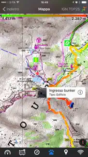
- Save waypoints with photos and descriptions
- Navigate to a point of interest
- Sharing via Facebook and Twitter
- Follow a path/track
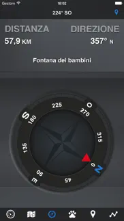
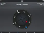
- Navigate (distance / direction) towards any waypoint
- Navigate (distance / direction) towards any track marker (start / pause / resume / end points)
- Advanced Navigation to a waypoint using any navigation app you may have installed
- Upload tracks to GPSies (http://www.gpsies.com)
- Upload tracks to SportTracks (http://sporttracks.mobi)
- Upload tracks to OpenTrail (http://www.opentrail.us)
- Upload tracks to OkMap (http://www.okmap.org)
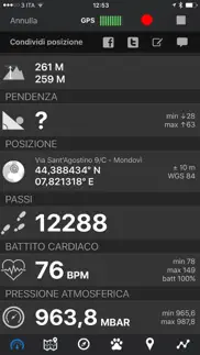
- Real-time visualization of distance, speed, altitude bearing and other data
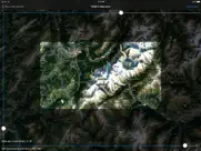
- Map Visualization in different modes: street map, satellite, hybrid, terrain
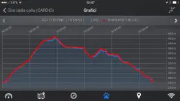
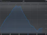
- Charts (elevation profiles, ...)
- Digital Compass
- Heart rate monitoring
- Turn by turn directions
- High battery duration (record in standby)
- Select between metric, imperial and nautical measuring systems
- Intuitive and User Friendly interface
- Lightweight, reliable and accurate
- Doesn't require internet connection
Terms of Use: https://www.apple.com/legal/internet-services/itunes/dev/stdeula/
Privacy Policy: http://www.easytrailsgps.com/wp-content/uploads/2016/05/EasyTrails-GPS-Privacy-Policy.pdf
😍 Do you love EasyTrails GPS app? Please share your friends!

Please wait! EasyTrails GPS app comments loading...
EasyTrails GPS 11.4 Tips, Tricks, Cheats and Rules
What do you think of the EasyTrails GPS app? Can you share your complaints, experiences, or thoughts about the application with Zirak S.r.l. and other users?
EasyTrails GPS 11.4 Apps Screenshots & Images
EasyTrails GPS iphone, ipad, apple watch and apple tv screenshot images, pictures.
| Language | English |
| Price | $3.99 |
| Adult Rating | 4+ years and older |
| Current Version | 11.4 |
| Play Store | com.zirak.easytrails |
| Compatibility | iOS 11.0 or later |
EasyTrails GPS (Versiyon 11.4) Install & Download
The application EasyTrails GPS was published in the category Sports on 14 August 2009, Friday and was developed by Zirak S.r.l. [Developer ID: 325929835]. This program file size is 29.26 MB. This app has been rated by 226 users and has a rating of 4.5 out of 5. EasyTrails GPS - Sports app posted on 16 January 2024, Tuesday current version is 11.4 and works well on iOS 11.0 and higher versions. Google Play ID: com.zirak.easytrails. Languages supported by the app:
NL EN FR DE IT PT RU ZH ES ZH Download & Install Now!| App Name | Score | Comments | Price |
| EasyTrails GPS Lite Reviews | 3.3 | 16 | Free |
fix: app layout on newer iPhone devices
| App Name | Released |
| Adidas | 03 November 2017 |
| FotMob - Soccer Live Scores | 21 December 2011 |
| MLB | 29 February 2012 |
| 18Birdies Golf GPS Tracker | 05 July 2014 |
| Fishbrain - Fishing App | 23 February 2013 |
Find on this site the customer service details of EasyTrails GPS. Besides contact details, the page also offers a brief overview of the digital toy company.
| App Name | Released |
| QZ - qdomyos-zwift | 10 December 2020 |
| InfiniteHoops Whiteboard | 06 January 2013 |
| Ballistic X | 27 January 2019 |
| PractiScore Competitor | 29 March 2017 |
| Lineup Assistant | 29 September 2019 |
Discover how specific cryptocurrencies work — and get a bit of each crypto to try out for yourself. Coinbase is the easiest place to buy and sell cryptocurrency. Sign up and get started today.
| App Name | Released |
| Venmo | 02 April 2010 |
| Duolingo - Language Lessons | 13 November 2012 |
| X | 09 October 2009 |
| 12 February 2019 | |
| 05 February 2019 |
Looking for comprehensive training in Google Analytics 4? We've compiled the top paid and free GA4 courses available in 2024.
| App Name | Released |
| HotSchedules | 30 October 2008 |
| Terraria | 28 August 2013 |
| The Past Within | 02 November 2022 |
| 75 Hard | 19 June 2020 |
| The Wonder Weeks | 30 May 2012 |
Each capsule is packed with pure, high-potency nootropic nutrients. No pointless additives. Just 100% natural brainpower. Third-party tested and validated by the Clean Label Project.
Adsterra is the most preferred ad network for those looking for an alternative to AdSense. Adsterra is the ideal choice for new sites with low daily traffic. In order to advertise on the site in Adsterra, like other ad networks, a certain traffic limit, domain age, etc. is required. There are no strict rules.
The easy, affordable way to create your professional portfolio website, store, blog & client galleries. No coding needed. Try free now.
EasyTrails GPS Comments & Reviews 2024
We transfer money over €4 billion every month. We enable individual and business accounts to save 4 million Euros on bank transfer fees. Want to send free money abroad or transfer money abroad for free? Free international money transfer!
Great app. I have used it mostly to mark trails I have been creating on my property and it works great! Have also used it when flying and works great then too! Would definitely recommend paying for the full version if you need it
Hard to find maps. If you're hoping to download maps or trails that others have already posted, you're better off with Everytrail. Easytrail does not have it's own collection and finding gpx maps on the web isn't as easy as you would think. Even if you find a map of a trail you want to explore, it won't load if there are too many waypoints.
Awesome. I don't really use all the features because I am not a hiker but it is really cool to have. Totally worth the money if you would actually use it for hiking
Simply Great. Love the simplicity, the graphs, and maps. Will definitely be using this as my new GPS device on our hiking and biking. Great work and design.
Easy trails. I really like this ap! It was a bit slow for me on loading, but it seems to have it all. I will never be lost again. Close trips work as well as long trips. I can't wait to try it while camping in the Ozark mountains!
This is great!. This app is something everyone could use! I love everything about it! Thanks :-)
Works Great for Ride Tracking. I have used Easy Trails to track my trail riding mileage for several years. It’s simple to use and functions even when I don’t have cell service. It’s also super easy to export tracks to TopTrail. It would be great if I had the ability to edit a track when I occasionally forget to turn it off when I am done riding, but otherwise I love it.
Steps. Can’t find a way to reset “Steps” at start of a hike
Trail dragon. I love this app, been using it for years. Wondering if anyone else questions accuracy of the speed part of the app. For myself it is not accurate. Other than that I love it!
Very cool. This app is actually pretty cool. I tried it for mapping a 2 mile course around my neigborhood. since the same route gets boring I'll probably use this app all the time.
Very useful for my needs. This app is perfect for GIS grade trail mapping and property reconnaissance. I use the custom coordinate system option to collect data in my local state plane zone. The email export function sends GPX and Google tracks that work seamlessly with my Carlson Survey and ArcMap software. Pretty cool stuff.
Very helpful.. I used this app the other day to track a path I had found near my house. Instead of getting lost, I was able to retrace my steps and get home safely. Amazing app and very nice to have!
Great app. Now need HealthKit integration.. Great last update. I am loyal user and have been using this for years for hunting and cycling. I would love some sort of HealthKit integration so I can import cycling data or something.
Truly Amazing. I have tried few GPS tracking applications before and all those were either slow to pickup GPS signal or consumes more power. But this one is great. Export options are incredible. However i noticed the altitude is not accurate, shows increase in altitude even on a flat surface.
Excellent for Trail Map Creation. Wonderful app for creating trail maps with points of interest along the trail. You can use the IPhone camera to capture the POI. Very easy to use -- Just start EasyTrails and push the record button. It automatically collects the GPS points and displays the trail as you walk. It works great with the IPAD and the IPhone. In my experience,the GPS sensitivity on the IPAD is much better than my Garmin Etrex that I have used to document trails. I found that you can start EasyTrails recording your trail on the IPAD and then put it in your backpack. It recorded a new 5 mile trail perfectly. It doesn't get any easier! I found the altitude and distance seemed to work fine! You can export the trail via email and share with friends. It also creates a GPX file that can be used with other programs and Google Earth!
Great app!. Excellent app. Very accurate tracking. Easy to use. Please join me in spreading the word about the biggest cheating app in the app store. A pool game called Micropool by Botond. Horrible game. Please read the reviews if you don't believe me. Please help by telling everyone you know about this atrocity. Thank you.
Awesome for tracking snow plow route. I love this app. I use it to track my route when I snow plow and it tracks location and times and makes it simple and easy to read. The maps are accurate and easy to read as well. The only thing I wish it had was the ability to add notes at specific points in my route.
Best App That Works Great!!!. This app is worth the $$. I don't leave home without it. I use it for hiking, biking, canoeing etc and LOVE it. I love the fact that you can start where you left off. I also love the feature that allows me to take a pic of where I want to go next and then give me directions. I've seen places in route that look cool then take a photo and have directions the next time I want to visit. Awesome. Keep up the good work!
Great Trail Equine App. This app has delivered from local trail to the Big South Fork! Thank you! Vicky Rhein
Very accurate!. I use this app for all my hiking and biking and it has always worked great. It also quickly connects with satillites when first turned on.
Disappointed. The app would not let me share my trails and then when I tried to re log in again, my 2 trails were gone. Not worth the $4.
Avoid if your purpose is waypoints. I purchased this application just for the feature to see "bearing & distance to the waypoint", as I have many waypoints, and this is pretty much the only feature I care about. After extensive time playing with it, I could not find the feature. Finally I contacted the customer support and got the reply: "To do that, you have to start the recording of a track, move on the "map" tab, select the waypoint and press the right arrow in the callout. Then will appear the compass page with a red bearing pointer and the distance from the destination" This is so complicated that it is not useable at all. Plus, why would I have to start recording a track in order to see distance & bearing to the desired waypoint? It makes no sense. Finally, I uninstalled it & got MotionX GPS, which works as I expected.
WOW... waypoints and long battery duration. with the waypoints I think that EasyTrails GPS is really the best app for outdoor tracking. I use in several ways, and it's simply amazing! Then I've seen also that they support environmental projects with the revenues, a good point to support them!
Does not work!. I just installed IOS 4 and guess what Easy Trails does not record while on stand by anymore. I use this app for Mountain Biking but now I have to wait for and upgrade or for them to fix this bug. Dont buy this app if you have an Iphone 3G! Tried contacting custumer service but never recieve an answer. Upgraded to version 4.1 still does not work!!
Not great for skiing. The app doesn't have ski trail maps, so you can't really see where you've been. If you lock your phone or press the "home" button after you start recording, it stops the recording. You're just supposed to put your phone in your pocket and hope nothing gets pushed. A call also stops the recording. All measurments are in KPH and Meters - which is super fun for us Americans. Overall, not worth it - sorry.
Terrible app. This app is difficult to use and it does NOT have anyone to help when you have a problem. Dislike this sort of Junk!
Battery hog. This app shows promise but it's a huge battery hog. Even a modest 2-3 hr hike will kill the iphone battery. Big problem when you're in the field with no access to power. Also would be useful if it could pull up existing trail maps from the vicinity and overlay them with the live route map.
No support can't find GPS signal. Used the app for two months worked well. Then suddenly quit finding GPS signal. Could find no help. Deleted App, reinstalled, still no signal and lost all my tracks.
Their support is amazing.. We've all seen it: the 'Contact Us' or 'Feedback' or 'We Love Suggestions' button. If we're really passionate, we tap it and spend 10 minutes crafting the letter we're *sure* will get noticed. We tap 'Send'. A few seconds pass and a clearly automated message thanks us for our feedback, and we never hear from them again. Then we stop using the app. Not this time. I requested a feature, and not only did they reply with a thorough explanation, but they've continued to send me updates as they address new features and behaviors that came up in the resultant conversation.
Great GPS App!. So far this is the best and most reliable outdoor GPS app I have found of iOS. It is perfect for hiking, biking, geocaching, etc. The app is fully featured and tracks all of your movement data, allows waypoint input and tracking, track saving and uploading, as well as stat breakdowns of your tracks. GPS is very accurate, maintains a signal very well in a pants pocket, and doesn't kill battery life. HIGHLY recommend this for anyone looking for a great outdoor GPS app.
In-app purchase won’t work.. I purchased the ability to download maps offline, unfortunately, after trying forever to figure out how to simply get an API key for Google Maps because of poorly written instructions, the app crashes the instant that I try to paste or type the API key. Otherwise, the app is great as long as you have service. I’ve used it for years. It desperately needs an update.
Great app-almost perfect. I love this app and would rate it perfect except for lacking a default when trying to save a track. It's inadvertently failed to save a track. I use a Garmin GPS as a back-up just for the few times tracks either got stopped or failed to save.
Looks good but how to use?. I am just starting to use this with no GPS experience. I don't know how to use it and the developers have no tutorial on using it, in the app or on their website. They have a facebook page with lots of comments and "please give us a good rating" but no practical info. Even the FAQ page is more advertising than teaching. I will come back and rate this higher if . . . I can figure out how to use it.
Trail Riding. My wife and I go trail riding on our horses on the weekends, this is the greatest app for that! Not only can you track the trail you can also take pictures on the way and you can share it with your friends through many different apps!
Lives up to its name. I have several trail apps for tracking Trails from horseback. I always turn to Easy Trails as it is straightforward but has all the features I need.
Trail rider. It’s great it’s keeps up with the miles I drive my team of mules
Easy, life-saver. Makes bikeriding just that much more fun, keeps track of where you go with phenomenal precision, I put it on a holder on my handlebars and it works as an interactive GPS, not to mention after the ride I get a details analysis of my ride including all sorts of charts and data, well worth the money if you are an avid biker!
Bugs. App nagged me to write a review so here it is. Offline maps are great (but additional cost) but this app has a number of bugs. For example it keeps on announcing it is following a route and does this long after I finish a route and I've killed the app. I don't know how to remove from memory. I'll try a hard reset. Anyway the app is mostly good but has some annoying bugs.
Pretty Good. I've tried a lot of these and I like this one the best! the dashboard and compass are great when your out somewhere you've never been and uploading trips to friends is cool. worth the price, and looking fwd to updates.
Excellent map app!. The big library of overlay maps (Caltopo, nautical, Google, OSM, etc) set this app apart from the rest. Use it all the time!
Great Mapping App. Super easy to use!
Very nicely written App. Works exactly as advertised. Maps are accurate and charts are accurate. The settings can easily be changed from metric to imperial (through IPhone settings - the comments on some reviews that it cannot be done is simply wrong). One suggestion: It seems the altitudes are derived from the GPS. I have seen other apps that show altitude based on Map location. It would be useful if one could change the settings to measure altitude based on the Map position.
LOVE LOVE LOVE this app!!. I ride horses and use it to track my rides. I have truly tested having no cell service and depending on satellite and it continued to track me real time. I even got lost in a national forest and used the map to track back to my original starting point (I use this frequently in forested areas). I am also able to push my racking horse and see out speeds improve with the "maximum speed" tracking. It will also show you local roads that you maybe near should you find yourself in an accident. It does far more than I need it to and everything that I want it to. Well worth the money! I have tried a few others and was disappointed in their performance and that they "lost" me in poor reception areas. With a little bit of photo editing skills and a good program you can even use these tracks to make trail maps for public areas. My only suggestion: if you are horse back riding, strap the phone to YOU not the horse! Every time I show people a track of my rides they want to know "What's that app!?" EasyTrails! Love it!
User Friendly. I'm pretty good at learning by using and this app makes using without training easy. While they could have additional information available, this app is great for recording trail rides.
Great, Fun and Easy!. Just downloaded this on a whim.... My Garmin bike computer needs a new battery to the tune of $50+ for the service, so thought I'd give this a go. Went on a 22 mile mountain bike ride, and had easy tracker track our ride. It worked great, the only thing I noticed amiss was the assent and decent numbers didn't match, which if you start and end in the same place, of course should match. But overall, the 3 types of maps are quite cool, and shows the locations that we stopped with yellow push pins the overall time as well as the actual time we were moving. The ride was easily exported to email and mailed to a friend....Just not sure how to open a GPX file.....Guess I'll have to figure that out, maybe the developer has some info on that.....HIghly recommend.
Great app for hikers. I use it to record tracks for hiking trails. Only issue I have had was when iPhone X came out and they fixed that promptly.
Only measures in Km… not miles or feet. Click the back button.... … now and find a useful app. This apps works perfectly, if you are willing to buy another app to translate the results into something usable. All I wanted was an odometer to measure the length of my bike rides. I might as well hold up a cup and measure how much air is in it or an app that measures the fraction of a lightyear my trips are. They would be just as useful. The free app is worthless… not even a try out. This expensive app is just as useful as the free one. I can understand why they do no warn you in the description. That is how they make their money since there is no way to get a refund.
Show off your tracks. What makes this app different from most of the others is the sharing feature that lets you transfer tracks in and out. You can transfer to your PC in 3 formats. You can transfer old gpx tracks to the iPod and show them on the map, Very slick.
Great App. Been using this app for years. Very easy to navigate. My go to app
You can switch from metric to imperial and back.. I've used this app for about a month and it seems to work fine. You can switch between metric and imperial measurements by going into the settings app on your iPhone. Scroll down to the bottom and you should see a list of apps for which you can change the settings. Go to the EasyTrails tab and you will be able to change the units as well as some other settings.
Did you know that you can earn 25 USD from our site just by registering? Get $25 for free by joining Payoneer!
Good detail but needs some fixing. EasyTrails is a great program, though I have noticed that once the program acquires a GPS signal and starts recording a track, if it losses GPS signal it will stop recording data from then on rather then trying to require signal and continuing. For example my 10hr recording only had the first 2 hours and then stopped recording data even though it said it was still recording the track. If this is a battery saving feature then it would at least be appreciated for there to be the option for the app to keep seeking GPS and resume recording data for the track as soon as it can instead of giving up. I tried using your contact form but it was not working.
GPS updates. GPS updates are very poor compared to other products e.g Runmeter or the iPhones Maps. In built up CBD location, Rumeter tracks well but Easytrails is very slow and in one instance did not update for 15min. Could also be enhanced by being able to do splits, e.g at half way points etc.
Great App. Great app. Everything I want in a GPS app with a fantastic interface.
Good App. This is a good app, however it would be much better if you could use it for gps guidance.
Easytrails. Works well. Easy to use. Does everything the description says.
Easy-to-use, Responsive & Stable. I've tested quite a few GPS tracking apps, and EasyTrails GPS is one of the best in terms of overall user experience -- it's easy to use, responsive and stable (which, unfortunately, cannot be said for many other similar apps). While it may lack some of the "professional" and/or activity-specific features, it's definitely more than adequate for most users, and even greater if you just need a solid tracking app with GPX export (say, to be fed to a more sophisticated application and/or online service). I would have given it a five-star rating only if it offered sampling frequency control and filtering (i.e., record only when the horizontal accuracy is within certain threshold).
Easy to use, reliable. Been using this app for a number of years for hiking. Always dependable.
Imagine you at your best. All the time. Picture yourself at your sharpest and most productive. Your most alert and focused. Your most lucid, creative and confident. At work. At play. In every area of your life. Add Mind Lab Pro® v4.0 to your daily routine and uncap your true potential. Buy Now!
Great app! Wish it could save maps for longer. This app is amazing for dirtbiking and mountain biking, never get lost again and my battery usually stays pretty full. Wish it would hold on to maps better, usually have to put my phone in airplane mode or it will update mid ride and blank out the screen, that didn’t used to happen. Otherwise awesome app!
Easy Trails GPS 5. Very happy with this app. It worked up at the top of a mountain and since we got lost for a bit it was nice to look at the map afterwards and see where we went wrong :) also, I still had battery left after it ran for 2 hours!
Good enough. This app does its job pretty well, and as long as you don't expect too much it should be plenty. It uses less battery power than the similar MotionX app, and getting tracks from the app to the computer is very easy. My only gripe is that there are no "speed vs. time" plots, when they seem to have everything else covered.
Very satisfied. I purchased this to track my mountain biking and map trails near my house. This app works great and runs in the background. Great app!
Great, but what about a watch app too?. This app is one of my favourites for the iPhone. I use this every time I go hiking, jogging or cycling... but please... PLEASE create an Apple Watch app too. This would make it so much more enjoyable. I would have made this a 5-star rating if I could use this on my watch.
Fair app. Can replace a pocket GPS unit for a couple of days. Does not hold offline maps more than 3-4days I think. No major bugs to report here. Waypoints and trails work great with Google Earth both upload and download!
Awesome. Been using this app for 3 years now and it works great for fishing and hunting waypoints. Cheap alternative to buying a GPS.
Dover Street Boy. We use Easy Trails all the time no matter where we go or what we are doing!
Almost there.... If you could import .klm files, this app would be awesome, but right now it just shows you gps point (a single at a time) unless you recorded a track...
Just perfect!. I bought this app long time ago and I have been amazed in every single update. I just love it. It is simple and gives a huge value. Congrats, I can tell there is a big piece of work behind this.
Love it. Easy to use and useful
Adsterra is the most preferred ad network for those looking for an alternative to AdSense. Adsterra is the ideal choice for new sites with low daily traffic. In order to advertise on the site in Adsterra, like other ad networks, a certain traffic limit, domain age, etc. is required. There are no strict rules. Sign up!
ottima apps. Come al solito una ottima apps! sempre utile anche in città!
I want a refund!. How can this app not be measured in miles/yards? But only km... totally absurd! What are the developers thinking? They must not know who their market is...
Great. Useful to find which is the shortest routes
Easy to use!. Best app out there. Flawless.
Very good GPS logging app. This is a strong consideration for anyone looking for a geo-logging app. The app shines with the constant logging feature of the app. This app actually works with the phone's sleep mode -- not some "fake sleep" dim screen mode that other apps use. That works great for me, I'm so used to pushing the phone's sleep button that disables other apps. The other killer feature is the signal strength indicator -- let's you know the quality of the gps fix on the phone -- which is awesome. I've tested many apps that log gps data, but without knowing the quality of the signal, you may end up with invalid data or even no data. Although there is a speed and altitude indicator -- neither one are very accurate. I can be standing still at the beach but it reports I'm moving at 10 mph and at 95 ft above see level. It is more or less dependable based on the quality of the gps lock, but even with the best signal strength -- these values are way off. In addition, I wish the waypoint/manual point entry was easier or more streamlined -- and could be done without interrupting the existing recording. For constant logging mode, it would be great if you could control the frequency of the data points recorded -- that might save on battery life. I think it should be an option at least. The help or documentation (online or on phone) is much better than most other apps, but still very lacking. Most apps have no documentation at all -- some documentation is better than average. I'm using this app for geo tagging my photos. It allows access to GPX (and other) files via an internal web server -- which is great. As long as the date/time on my camera is in sync with the phone -- my photos get geo tagged very well with GeoSetter (free). This app is better than most photography centric gps logging apps -- not many photographers know about this app because it is listed under Sports section instead of Photography. For my purposes, it is currently my favoriate app for geo-tagging, but still has plenty of room for improvement. I look forward to future releases.
Trailrider. I love this app. Convenient to use the powerful GPS on the phone. Easy to use and save & share.
A very good app with a minor annoyance. It's annoying to get a prompt to turn on Bluetooth every time I open the app.
Easytrails. Love this app. Great for trail riding.
Great Riding app. Love this app easy to use. I love that I can export my tracks easily. I can easily add them to my log on OpenTrail.us or email them to my computer to add to my GPS file in gpx form. Many other options too. Works great and is easy to follow old tracks too.
Happy. Price is right, tracks all of my rides and makes them easy to share. Very satisfied!
Very Useful. I like this app! I helps me record walks and bike rides.
Not a very user friendly app.. This app is very hard to understand
Perfect. Great for my weekend hiking
Great app. It exports kml over wi-fi. Great maps/waypoints/ and stats.
Battery eater. Don't know how they say it does not kill the battery, b/c it does. Severely. Otherwise good.
Easy trail. Not bad. Wish thecapp was a bit faster to update as the track is being recorded.
.... When i open the app it says "waiting for signal" and i waited like 2 minutes and it still says waiting for signal... Please fix it
Easy Trails App. This is GREAT for horseback riding. Nice to look back and see distance, time, top speed, etc. when trail riding. Map is cool too. ❤️❤️❤️ It!!!
No. Don't like it at all get more info from a simple topographic map
Great App. I use this to record hikes, bike rides, and jogs. I love the interface. Solid app.
Nice. This is a nice little program. Easy to use and I like the option to import and export data.
Highly recommended. Great app. Easy to use and it continues to be enhanced. Support has answered every question I've asked. 5 stars.
Exactly right. Love this. Especially the maps and charts
ottima app. ottima applicazione semplice ed intuitiva per le mie escursioni a cavallo
Wi-Fi Sharing did not work, but now it does. Cannot get the Wi-Fi sharing to work (however I can get other iphone apps that support sharing to work). Cannot get any technical support to respond to questions about this. I followed the tutorials on the website, but to no avail and there is no troubleshooting support. It's a bit of a shame, as I really like the app. So I give it three stars for the other good stuff that does work and seems to work well. Equipment: iPhone 3GS and Windows Vista using either IE or Firefox. UPDATE: The probelm with the Wi-Fi, I discovered by working at it by trial and error (without any tech support), was not having the Wi-Fi configured properly on my iPhone. Not the fault of the developer or the app. So given this fix/discovery, I would say that this is a 5-star app even without hsving any tech support. I felt it important to provide this update for those of you looking for an app like this that works they way it is supposed to work. If your Wi-Fi sharing is not working, a likely problem will be your Wi-Fi configuration settings on your iPhone. Symptoms of not working are no IP addresses provided by the app or ones without a port number. The full IP address discovered by the app and displayed on the share screen should/could have a port number. If no port number provided and still not connecting, append ":8080", the usual default, to the IP address given (e.g., for your router) in your web browser. Hope that this helps. This is what worked for me.
i´m hocked!. i think i caught the easytrails fever! i´m using it in so many ways! Its also great to use visiting new cities...
Waypoints. Very good app and very good company - with a few changes it will be the goto app for fishing and for going from waypoint to waypoint . Very responsive customer service Capt. Sam
Perfect for my needs. I use it every weekend for my trips. Very recommendable.
Nice Interface. Very nice app with easy to use interface. Great for transportation by foot or other short distances.
Tracks pausing. Of late my tracks are pausing spontaneously. Please fix—this was one of my favorite apps.
Easy map. You really need to add a tutorial.