INavX: Marine Navigation App Reviews
INavX: Marine Navigation App Description & Overview
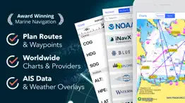
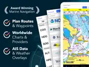
What is inavx: marine navigation app? Marine navigation is made easy with iNavX - the world's #1 handheld Chartplotter. Access marine charts, maps, weather, AIS and more!
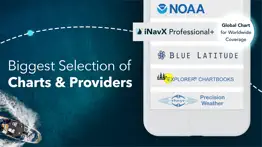
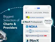
iNavX is the only app to give you complete worldwide chart coverage, from all your favorite charts providers, including the ALL NEW iNavX Professional+ Chart series! Fully enabled with one-touch access, iNavX gives users access to the broadest set of marine charts and maps from multiple providers including:
• iNavX Professional+ Charts
• Blue Latitude
• CHS
• Explorer
• Theyr Weather
• Waterway Guide
• … and more
How does iNavX take handheld marine navigation to the next level?
• Sailors - Plan sailing routes with waypoint and route management. Get proactive sail management with GRIB weather forecasts and then keep watch with AIS overlays and integration with your onboard systems. Plus, you can remember your great sailing locations by geotagging photos.
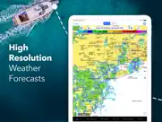
• Boaters - Stay up to date on boating conditions with forecasts that include currents, winds, and swells. Manage your boating equipment with nautical instrument integration and then save great boating routes to share with the track log.
• Anglers - Discover new fishing spots by scouting out holes and inlets. Locate the best fishing conditions by identifying cold fronts and save your best fishing spots with unlimited markers.
Advanced features - iNavX is the most feature rich app available for all sailing and boating needs at a great price:
Advanced Chart Plotter
• Plot your position in real-time using your device's built-in GPS
• Pan, zoom, and rotate charts (including course up)
• Print detailed charts to use in combination with the app
Advanced Navigation
• Create waypoints and plan routes to navigate between them
• Track log allows you to record your route
• Import/export data in KML (Google Earth) or GPX format
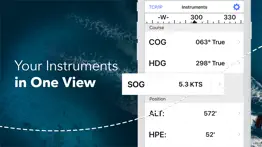
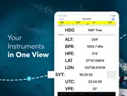
Advanced Instrumentation
• Supports NMEA data over TCP/IP (using Wifi)
• Integrates with external GPS, AIS receivers & transponders
• Connect nautical instruments: Depth, Speed, Wind, Engine, Batteries, etc.
Essential Toolkit
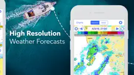
• GRIB weather forecast
• Tides/currents
• Anchor alarm
• AIS integration
• Port/navaid search
Download iNavX TODAY and automatically receive a complimentary copy of the official and up-to-date high-resolution NOAA RNC United States marine raster charts.
REVIEWS
“iNavX is the original and still one of the best navigation apps.”
– Practical Sailor
“The most full-featured navigation app around and viewed by many as the standard”
– Sail Magazine
"The #1 recommended marine charting app"
- iMarineApps
iNavX is Compatible with: Theyr Weather, Waterway Guide, AIS, Brookhouse, DigitalYacht, ShipModul, vYacht, Vesper Marine, NMEA 2000, Chetco and more.
NEW CHART STORE
Purchase all your favorite charts. Chart subscriptions vary by chart and provider from $9.99 to $199.99 annually, charged to your iTunes Account, which will automatically renew unless cancelled at least 24 hours before the end of the current period. Auto-renew can be turned off anytime by going to your Account Settings in iTunes after purchase. No cancellation of the current subscription is allowed during active subscription period.
NOTE: Continued use of GPS running in the background can dramatically decrease battery life.
MORE INFO
Website: http://inavx.com/
User's Guide: http://inavx.com/help/
Terms of Use: http://inavx.com/terms
Privacy Policy: http://inavx.com/privacy
😍 Do you love INavX: Marine Navigation app? Please share your friends!

Please wait! INavX: Marine Navigation app comments loading...
INavX: Marine Navigation 5.6.30 Tips, Tricks, Cheats and Rules
What do you think of the INavX: Marine Navigation app? Can you share your complaints, experiences, or thoughts about the application with NavX Studios LLC and other users?
INavX: Marine Navigation 5.6.30 Apps Screenshots & Images
INavX: Marine Navigation iphone, ipad, apple watch and apple tv screenshot images, pictures.
| Language | English |
| Price | Free |
| Adult Rating | 4+ years and older |
| Current Version | 5.6.30 |
| Play Store | com.gpsnavx.iNavX |
| Compatibility | iOS 13.0 or later |
INavX: Marine Navigation (Versiyon 5.6.30) Install & Download
The application INavX: Marine Navigation was published in the category Navigation on 12 February 2019, Tuesday and was developed by NavX Studios LLC [Developer ID: 286616283]. This program file size is 292.11 MB. This app has been rated by 18,417 users and has a rating of 4.7 out of 5. INavX: Marine Navigation - Navigation app posted on 25 January 2024, Thursday current version is 5.6.30 and works well on iOS 13.0 and higher versions. Google Play ID: com.gpsnavx.iNavX. Languages supported by the app:
NL EN FR DE IT ES SV Download & Install Now!| App Name | Score | Comments | Price |
New Charts for Mexico
| App Name | Released |
| NAVER Map, Navigation | 01 May 2009 |
| Google Maps | 12 December 2012 |
| Find my Phone, Friends - iMapp | 26 July 2014 |
| PlugShare | 07 March 2011 |
| Premium Parking | 22 October 2013 |
Find on this site the customer service details of INavX: Marine Navigation. Besides contact details, the page also offers a brief overview of the digital toy company.
| App Name | Released |
| Blitzer.de PRO | 03 August 2022 |
| CDOT Colorado Road Conditions | 21 October 2020 |
| Holding Pattern Trainer | 16 August 2011 |
| Ship Finder | 01 April 2010 |
| Land Nav Assistant | 18 May 2012 |
Discover how specific cryptocurrencies work — and get a bit of each crypto to try out for yourself. Coinbase is the easiest place to buy and sell cryptocurrency. Sign up and get started today.
| App Name | Released |
| Uber - Request a ride | 20 May 2010 |
| TikTok | 02 April 2014 |
| Messenger | 09 August 2011 |
| 12 February 2019 | |
| Telegram Messenger | 14 August 2013 |
Looking for comprehensive training in Google Analytics 4? We've compiled the top paid and free GA4 courses available in 2024.
| App Name | Released |
| FL Studio Mobile | 21 June 2011 |
| Ultimate Custom Night | 28 April 2020 |
| Plague Inc. | 25 May 2012 |
| Slay the Spire | 13 June 2020 |
| Incredibox | 27 March 2016 |
Each capsule is packed with pure, high-potency nootropic nutrients. No pointless additives. Just 100% natural brainpower. Third-party tested and validated by the Clean Label Project.
Adsterra is the most preferred ad network for those looking for an alternative to AdSense. Adsterra is the ideal choice for new sites with low daily traffic. In order to advertise on the site in Adsterra, like other ad networks, a certain traffic limit, domain age, etc. is required. There are no strict rules.
The easy, affordable way to create your professional portfolio website, store, blog & client galleries. No coding needed. Try free now.
INavX: Marine Navigation Comments & Reviews 2024
We transfer money over €4 billion every month. We enable individual and business accounts to save 4 million Euros on bank transfer fees. Want to send free money abroad or transfer money abroad for free? Free international money transfer!
Frustrating. I want to love this app because it provides access to NOAA raster charts. I like the simple interface and obviously the portability, as well as iPad and iPhone support. As a navigation tool it should never interrupt or distract the user with irrelevant information, and unfortunately now it does. I would happily give it five stars if it: 1) removed the pop up ads and “tell us what you think!” surveys. 2) improved chart switching. Right now it takes far too many taps to locate adjacent charts or charts at different scales. You have to slog through the entire chart library to find charts you already have, and the search function doesn’t seem to work with chart numbers. 3) improved lat/lon coordinate entry. Scrolling through every degree/minute second is tedious and should be replaced with direct entry. I want to use this app but find I use Transas iSailor instead...much more complex but more purposefully designed.
Like the charts but not the UI. I like the charts this app uses but am not at all impressed with the UI. The UI for selecting the appropriate chart is particularly clunky. I find it takes me a number of tries every time to get the gestures right for to create or edit a waypoint. It works well to create routes in another app and import them into inavx. I use Open CPN on a Mac laptop for planning. This works much better for creating routes.
Is it worth it?. Everywhere you look you would think you can use Navionics Maps - nope, no longer available. Oh, how about C-Maps? These are even listed on recent advertisements - Nope, no longer available. But, you can purchase the INavX maps subscription for $60, in addition to the cost of the app. Or, you could go straight to Navionics and use their maps for $20 with their free app, or go to C-Maps and use their maps for $15 with their free app. Oh, but INavX does let you use the old NOAA raster maps for free, but then so does pretty much every other free app out there. Might be a good app - don’t know, not going to pay 3 to 4 times more for their maps than the extremely highly rated and industry standard Navionics or C-Maps. Knowing this in advance I would have never purchased this app.
Good but not intuitive. I like the reference to original charts, but I find the interface to be a bit clunky moving between charts and zooming. On the other hand, it’s pretty obvious where the information is coming from compared to some of the other charting apps. This is a good app to have in conjunction to one of the other vector-based charting apps.
Overall Pretty Reliable. I will never buy another marine navigation app. iNavX has proven to be just as accurate as any instruments we have in the wheel house while offshore so I would recommend it to anyone who works offshore. My only complaint is when you rotate your iPad to landscape mode, the heading of your ship is being shown 90° to Port. That is beyond annoying. If that were fixed, iNavX earns an easy 5 stars.
Review. Hi I believe if you can use your iPhone or device with this program you can get anywhere like a map, lol well it is a giant water map with detailed information or pictures to adjust where you may be or need to go to. The next program that would be amazing would be a program that can be used without internet, WiFi, or anything that needs satellite interactions. Hope this helps you, much Aloha. Nicho.:)
Charts are not linked. I find that having to load and switch back and forth from chart to chart is not seemless enough. I used "Charts" app on the iPhone 5 but had to go with a new app with the iPhone 7 IOS 11. I recently went to the Bahamas and there were no NOA Charts of any detailed scale. I'll continue to try this out for around the chesapeake bay as it looks like it will work OK for that even thought I have to constantaly change charts manually from one scale to the next.
Accurate Precise works with GPS, but not sure of reliability. For $4.99 I should not complain. But, no Track Up???I mean, c'mon, how difficult is that to implement? Also I lose the chart sometimes and have to redownload. I fear that will happen on the fly when I meed the chart and do not have internet access on the water. So the $4.99 is a waste if I can't rely on it. For now though, it's worked well for coastal and bay cruising to keep me safe from shallows and obstructions. Really dislike North Up only, but I can live with that and hoping they'll come to their senses with a fix.
Great App!. Really appreciate being able to navigate and confirm my location using this app and my phone or iPad. Makes my travels much safer and efficient. Could be a little better, the pointing of the vessel, it often it shows me aimed in a different direction than I am, however i just use the corse line to make sure it’s aimed where I want to go.
Great system.. My integrated Pathfinder system is 20 years old, and the chart plotter is out of date. It works, but the chart plotter map is old, and updates are costly if you can find one. I tried this with an iPad as an alternative. It was confusing at first, so I read the instructions (duh). This is a really good low cost alternative that is effective, current, and does what I need. I still use the radar and depth finder on the old system. If you have trouble figuring out how to use it, remember the old adage, “When all else fails, follow the instructions.” They are clear and concise.
Good: hi-rez maps. Bad: user interface. I like how I can download free hi-rez maps without a subscription. What I can’t deal with is the user interface. It’s difficult to download maps, switch between maps, and I don’t know why the + and - symbols on a map attempt to do things other than zoom in/out, which is pretty much a standard convention for map apps. I prefer the UI of Navionics app. It’s way more intuitive.
The best chart plotter on the market. iNavX is the best chart plotter available. I’ve used it for years now and have it with me every time I step aboard. It’s mobile, it’s digital, it’s in my pocket all times. Most importantly it is easy to use, has all the charts I need for all over the world, and really handy features like weather and AIS.
Recommended by my sailing instructor. This app was initially recommended to me by my first sailing instructor. I cruise often now and bought many other marine nav apps but keep finding myself using iNavX. This app has all the features of my on board chart plotter and is more intuitive in my opinion. Thank you for keeping me safe over many years and creating beautiful memories. If you sail, do yourself a favor and incorporate this app into your regular equipment rotation.
Good App, but.... We have used this app for two years now, sailing out of St. Augustine, FL, and now bound around the world on our 35' sailboat. This app has many nice features and it has gotten us through the Caribbean, now 3,000 miles. I really like the way it works and the detail it shows. I prefer the Navionics charts. We run the app on our iPad2 as our primary chart plotter, and keep a back-up iPad2 loaded with the same charts. You are allowed to run charts on two devices for the one purchase price for each set of charts. Here's the "But...": This app does not support Active Captain. Active Captain is like TripAdvisor for cruisers. On chart plotters and apps that show AC, you can see details about ports, marinas, and anchorages right on your chart, complete with member reviews. If iNavX allowed Active Captain to show on its charts, it would be about perfect for navigation. Until iNavX supports AC, I will rate this a 4.
Very Satisfied. We have been using iNavx for years. From the start, found it extremely easy to use and equally helpful. Customized instrument settings provide the info you want balanced w readability and font size. Loaded on both iPad and phone (at Nav station and on deck). It is very simple to touch and drop a WP and to see location on chart; range; bearing; SOG; COG; VMG. Great tool and very intuitive from the start.
Great App. Fairly easy to use! I have been using a Furuno chart plotter which is a bear to operate. More time to figure out than time of actual navigation. I like the idea that I can down load and update any chart anytime anywhere. NOAA charts are free! Some of the procedures aren't as intuitive as I would like. I'm of an age where my memory isn't quite so good so would like to see a simple easy to use set of basic instructions. As it is an app on installed on my iPad It reduces the need for a standalone chart plotter and other computer gadgets greatly reducing onboard clutter and frustration. Overall, a great app at a fair price. Customer service is great too!
App constantly loses map base.. Each time I try to use this app, it says it needs to reload all the N6 maps and the x-traverse system is almost hopelessly complex... It always wants me to repurchase and renew some subscription or whatever. When it works it great but I never can get it to work and there's no helpline to correct it. Plus it cost a lot of money initially and they need more money every time I try to restart the app. Help... As of today 9-3-21 all Navionics N6 Charts have disappeared with no apparent way to reload the charts. App is useless with no charts. I don’t need charts for Norway as I’m in Minnesota… Looks like Navionics and others are no longer available in INavX? App is empty now and not useable!
Best app purchase ever!!!. I have had this app for over 5 years, and I have received immense value from the purchase. While it is always best to confirm location with other means, iNav has never failed me. Being able to have redundancy, on both my iPad and iPhone, allows for extra piece of mind. Updating charts is easy. I have traveled extended trips in the Great Lakes and connecting river, including anchoring out using the anchor alarm feature. This app will be a necessity in an upcoming Great Loop trip.
Use this app often if you work at sea.. This app was initially recommended to me by my first sailing instructor. I cruise often now and bought many other marine nav apps but keep finding myself using iNavX. This app has all the features of my on board chart plotter and is more intuitive in my opinion. Thank you for keeping me safe and creating beautiful memories. If you sail, do yourself a favor and incorporate this app into your regular equipment rotation.
Great nav program. We have used various versions of iNavX since it was launched many years ago. We used an early version while sailing in our home waters of Alaska. We used it down through Canada and into Mexico. We used it across the Pacific to Fiji and back to French Polynesia. We think that it's easy to use and stitches charts seamlessly. No nav program is any better than the charts for your area. Mexico has terrible charts, US and Canada have great charts, and many South Pacific countries have so-so charts. If your cruising area is well charted then iNavX will provide excellent navigation. Many of its features are better than our dedicated plotter's so it's worth owning and using.
5 stars!!!. Large set of maps for reasonable extra cost (at least as far as marine charts go). The interface and settings options make this app or choice for true navigation. And finally: you can plan your route at home, enter all the waypoints and then have everything handy at sea. Five stars well deserved.
Not practical, needs work. I bought it on sale for $5. You get what you pay for on this app for sure. Don’t understand all the hype. Downloading charts is second rate. You either have to download a very large area, e.g. USA East, or painstakingly select one chart at a time, after having to constantly get into download mode and scrolling through all the charts. Could easily be solved by allowing the user to randomly select different charts at one time once in the download section. Then since the char5s do t automatically scroll you have to pick a chart to use. Not smooth and seamless. Going back to Navionics or I may try the $8 Nautical, which allows better downloads and automatic scrolling of charts.
Off line use, iPod, bad elf for gps. The good: Very minimal investment for a functional chart plotter. Ability to add photos to waypoint. The not so good: Can’t knit charts. Can’t change route headings to magnetic. Can’t change weight of track lines. Chart inserts don’t download with chart. Too many non-nautical icons and not enough charting icons. Can’t add notes to routes. All-in-all a very useful app.
Stagnated. And push advertising. Not a lot of new features over the years but a lot of advertising. Also, when an advertisement says "x % off ALL CHARTS" it should mean all charts. But the promos never work on Canadian charts and the support persons never address the issues. Happens once I understand but this is a constant pattern.
Horrible app. This is perhaps the worse app for navigation available. User interface is childish and cludgy. For example, try to find Tuvalu on the chart. Map has hard stops rather than smooth scrolling. If your a tourist on a boat cruising one of the well beaten party holes, perhaps this is ok. If your cruising remote spots in South Pacific…forget it. Developers took the concept of ease of use and threw it out the door. Just to note, not only have I sailed for over 50 years, I was also an app developer for 20+ years.
INavX AIS LIVE. Bad app does not gives what it offers “World wide” coverage and that is plain false and the fact that it requires WFi or good Internet connection makes it useless for real ocean sailing, so it is too expensive for “no service” ( there is no way to get your money back even if you unsubscribe just 4 days after getting it) Xavier González Ortega
" Good app, very stable - User friendly, no-nonsense. ". Stable app. Easy and fast plotting and planning, correcting on the fly, panning and zooming. All you need and more for a fraction of the price of a RayMarine. Add a water tight housing (beware for direct sunlight exposure and subsequent overheating!), and you have your chart plotter at hand in every weather condition. I wouldn't want anything else.
Just terrible.. The least intuitive of any navigation app I have ever used. Forces you to select one chart at a time. And when you get to the edge of that map it just stops. You have to know which map to select next from a list of maps. Like I was using a stack of paper maps. Clunky and archaic. Incredibly frustrating to use. Scrolling along should automatically take you from map to map. Zooming in and out should not require me to select a map. The app has no smarts. For folks that have memorized all the charts I’m sure this is just great. But for me, it is unusable.
Very good navigation tool. We forgot our Garmin Marine GPS for a trip in Prince William Sound. Downloaded the application into our iPhones & were very happy with the results. Even with one bar in spots of the Sound the results were quite accurate. Some of the icons like rock hazards * were too large for necessary routes into meandering passages but eyes on the bow & a depth sounder made it a very useful tool. Speed over ground seemed spot on.
The One to Have. We have used INavX for 10,000 nm of travel, mostly on the ICW and adjacent waters. Because it used NOAA charts, it works well in part because we always have a paper chart handy just in case. At first, our blue water sailing friend was skeptical, but after two days he agreed that with INavX and an IPad, there is no need for a chart plotter.
Horribly organized charts. The main purpose of this app is to view nautical charts, and it fails horribly at that task. Viewing any one chart is fine, but switching between charts and trying to figure out which chart you need...incredibly frustrating. It is so completely non-functional that I will be deleting this app and requesting a refund. Future updates need to include a “my charts” folder where you can easily see a list of the charts you have downloaded. There also needs to be a large scale, infinitely zoomable map, that clearly shows the coverage areas of available charts, along with the name of the chart as a clickable link.
Fantastic app for all sailors. I just spent 2 weeks sailing running iNavX. Fantastic apps amazingly easy to use, very comprehensive in planning route, waypoints... very good maps easy to buy ... I have a lot of experience with PC based navigation software, iNavX brings the power of all these applications right at your fingertips ...
INavX iPad. Terrible program for an iPad. Beware purchasing this app/subscription for Alaska/BC/Washington. Old Navionics worked great and very practical. Garmin altered the program so route planning is a 20 or 30 step process rather than a graphics based process. Very awkward and very impractical. The NOAA data base is now stored and used by individual chart and is not stitched together like Navionics. For Alaska, all you can do is pick the correct chart from a list of 350 charts. Unless you know the chart name from an adjacent chart, you have to hunt and guess. This is very awkward and not practical. I have not been able to download 50% of the Navionics data base, and 50% of BC. How frustrating and amateur. There are other oversights and failures! I can not recommend this app or subscription unless Garmin invests some serious effort to revamp the software and eliminate the bugs.
Powerful and easy to use. Purchased on the water with our first boat when the chartplotter stopped working. Had to navigate some skinny bay water and the app performed its job. Since then I continue to use it planning out routes, fishing spots, etc and am very happy with it.
It USED to work.... There was a time that this was, hands down, the best app available for iOS. The originator, Richard Ray, worked pretty much non-stop on the app to make sure it was the beat it could be. Sure, there might be an occasional glitch. But it ALWAYS ran and did the job. Today, I can’t even get it to load, without crashing. I even bought a new 256GB iPhone 8, thinking it might help. And it did for a couple of days... until the next “upgrade”. Now I’m back to the same old thing... crash, Crash, CRASH!!!
How do I get my Navionics charts back?. I bought a new iPad for an update. All my charts got transferred except the Navionics charts. I’ve contacted the developer more than a week ago and yet to hear from them. So, how do I get my Navionics charts back? Please let me know how to do this soon. I go back to Panama in a month where the WiFi is slow and data transfer difficult.
Okay but not user friendly. While the app has a decent number of features the chart function is extremely not intuitive. The fact that every chart must be downloaded separately (around 8 for the Jacksonville, FL area alone), and swapping between charts in small area is difficult at best, is a very significant hindrance to this app. As a long time user of iPad aviation Apps like Foreflight, I expected marina nav apps to be similar. I may switch to Navionics, I've been told they download a more global chart.
Powerful app, but the maps. I was using the app with the noaa data for many years. very clunky with zoom in and out. Bought the USA maps upgrade and wow! Just got two more stars. Works like it should. App is complicated, lots of stuff, but way easier to use than handheld gps devices.
Un-User Friendly. This is the most un-user friendly app I ever downloaded. I’m going to uninstall this app and forget about it. I wasted $5, not a big deal. This company really needs to work on getting the app up in running when you log in for the first time. I don’t mind buying maps but I am hesitant to go any deeper into the map purchasing. When you download Navonics your up and running instantly. I’ve had two other people in my office trying to figure this app out with no success. I’m sure it works great once your up and running but I am throughly frustrated at this point. I seen the great reviews which made me take a chance but now I’m believing the reviews are a fraud. I run Furuno navigation on my 31 Hydra-sport and I figure this would have been a nice back-up but I was wrong. I wish I used the $5 on a Cheap Cigar!
Old bugs never fixed. In general, this is a pretty good app, but the evidence is that the author is not interested in fixing bugs. I have reported 2 bugs over 2 years ago with no results. First, exporting routes via email results in an invalid .gpx file. Specifically, the latitude specification sometimes does not contain the decimal point. Several times I have provided examples of the invalid files. As a software engineer, I know this should be easy to identify and fix. After more than 2 years, it has not. Second, iNavX often gets confused about what NOAA charts are available for the San Francisco Bay. NOAA has replaced some of the old charts. When the complete set of NOAA raster charts is downloaded for the West Coast, the names of replaced charts are still displayed, but it appears that they are not currently downloaded. When iNavX zooms in/out on the area that the deleted chart used to cover, it gets very confused and locks up. Again, I reported this about 2 years ago. It is still happening. It’s too bad. Fixing a few problems would make this an excellent application.
Circumnavigated in 2 yrs. Found iNavX to be very reliable and accurate everywhere we went, French Polynesia to N Australia, Indonesia to India, Red Sea through Mediterranean, Cape Verde to the South American Giuanas, Southern Caribbean to Panama, now up the Central American & Mexican Pacific coast. I highly recommend it as a compliment to a chart plotter. Charts for our B&G chart plotter are expensive so I don’t buy them and just use the generic world chart that comes free with the chart plotter. I subscribe to the iNavX Navionics charts per region as needed, and then plan my routes on iNavX, with all its visible detail, and transfer the waypoints to my chart plotter. I use iPhone 6 Plus but maybe a tablet, with its larger screen, would be better. Be great if someday PredictWind GPX’s could somehow be imported and managed.
Charts Won't Load!. I've had this app for 3 years now with no problems at all, and I loved it until now. I suddenly can't get the charts to load, just a gray screen. I restarted my phone and it just showed a very distant view of the charts (can't zoom in at all). I deleted and reinstalled the app, still nothing (IPhone 13 Pro Max, iOS 15.6). I had just renewed my subscription 2 months ago, what a waste of money! I live in remote coastal Alaska and need charts on my phone, so I'm going to cancel my subscription, delete the app and switch over to Savvy Navvy. And I want a refund please!
Can’t say enough bad things about this app. This is the most un-user friendly app I’ve ever used. The UI has zero intuitivenesses. Try to create a route to sail from one location to another? Add starting and ending waypoints and hit “go to” it shows a strait line route across land. I do the same thing in the Navionics Boating app and it shows the correct route through the water with the estimated distance and time it will take. After trying to figure out how to use this app I finally had to read the users guide. No help there. Totally worthless app, don’t waste your money like I did.
Easy and Simple!. I took my small craft out on the South Channel of the Straits of Mackinac for the first time last week. I was able to plot waypoints and get a heading within minutes. Our party traveled to Mackinac Island, Cheboygan and Bois Blanc Islands all week without a hiccup. We even navigated safely back to our port after the fireworks in a near moonless evening. Best $4.99 I've ever spent! This app, coupled with a handheld marine transceiver allowed me to boat in the Great Lakes with a 19' bow rider!
Very disappointed. I purchased a years subscription last November. Every time I go out for a cruise the battery on my iPhone gets sucked dry, in airplane mode! Wrote the company and their response was “Your one comment about the battery life may be remedied by the actually quitting iNavX rather than just putting it in the background.” It’s only when I am using it!!! There are other apps out there. This isn’t worth the money!!
Great, but flawed. This is a great app for the price. However, managing Chart downloads is extremely inefficient and time consuming. They should give you the option to download only specific regions (i.e. New England, or Florida) and not a whole coasts. They should also allow you to batch delete charts and not have to delete them individually, each with the multiple menu selections just to remove one chart at a time.
Exceptional!. I really cannot understand the recent (and few) negative reviews... I am slipped in the Santa Cruz, California small craft harbor. I have 20 year old integrated Raytheon electronics (fish finder, radar, chart plotter) and following the tsunami that hit our harbor, I lost the chart plotter functionality. Knowing that to replace my integrated system would cost me over 10K, I 'rolled the dice' and downloaded INavX to 'temporarily' replace the plotter as I was not prepared to haul out, $$$, etc. Well, over two years later I still am not planning a haul out for electronics as... I now am very satisfied with my IPAD/INavX next to my radar and fish finder. I currently have all my fishing and important navigation coordinates loaded and adding new ones regularly with a tap of the stylus. In actuality, don't even miss my old chart plotter... Thank you INavX... Captain Rich Bonny-Matit
Impractical. I really wanted this to work but unfortunately it is not a practical solution. I’m a full time cruiser on a sailboat, we do both coastal voyages and long open ocean passages. I was very excited about this app and dumped way too much money into various electronic charts. With the latest version, the app now runs in the background and constantly uses Location Services. It kills the battery of my iPad forcing frequent recharges, not realistic on a boat. I contacted Support and the only thing they suggest is to force quit the app every time you put down the iPad. That means every time you need a chart, you first have to reopen the app and wait for it to load — which unfortunately takes ~45 seconds with all the charts I have downloaded (on a brand new iPad Pro). Again, not realistic in the real world. Worst of all is the attitude I got from Support. You’d think I was asking for something unreasonable to have a working app after spending $200 bucks on charts. If you’re looking at this app, I would go with Navionics instead until the background Location is fixed.
Buggy update—BEWARE!. Ordinarily, this is the best marine nav app available (tho I’ve been asking for features in this latest update since the app was first released in the dark ages). Unfortunately, these long-overdue changes killed my ability to see my $90 Navionics charts (for which I was charged full price instead of the usual renewal price—but that’s another story). DO NOT UPDATE UNTIL THEY FIX THIS!
William Jennings. Absolutely Love it , bought it for $60 back in 2010 , a friend of mine bought a 32’ shrimp boat in Louisiana & it only had a cheap vhf radio on board & no other electronics , so I used my iPhone 4 & this app brought us home to Alabama.. I love that it’s entirely GPS BASED !!! No phone service necessary.. it works 100+ miles offshore... Truly Awesome Product ... charts are accurate!!! I will be upgrading to AIS live , in the near future.. it worked flawlessly on my iPhone 6S plus & now iPhone 8+ as well.. Thank You , for creating an awesome Product.. I’m a commercial fisherman
Did you know that you can earn 25 USD from our site just by registering? Get $25 for free by joining Payoneer!
Charge more, less service. Wrote a long review but since nickname was taken iTunes deleted the lot... For Australia I had issues with yacht club mark renaming to waypoint and nonexistent ais coverage in port Phillip bay, radio shadow west of the prom...iNavX not interested in feedback...it's way more expensive than in us, in particular with the $90 maps but almost no support outside, go figure.
Very unhappy. This application does not work on iPad Pro using Navionics charts. Do not download it if that's how you are planning to use it otherwise it crashes constantly after 5 minutes use. Unusable as an application until this is fixed- very disappointing. A total lemon in fact. No updates from an initial "we are trying to fix it" from the support email.
You have to pay AU$8 for nothing.. You have to pay AU$8 for nothing. Every feature in the app has another price. So the app should be free and charge only for what you wanna.
Garbage. Recommend you dont waste you money.
International Dateline issue. I used this app on a passage across the Pacific Ocean from Panama to Vanuatu loaded with the maps for this area. On the whole the app performed well on my iPad 3G which has built in GPS. But the Achilles heel of this app is when you transit the International Dateline which cuts through Fiji and I assume it would be the same in the N hemisphere as well. This makes it impossible to view the islands of Fiji in detail as you can only look on one side of the dateline and if you want to look on the other side YOU NEED TO SCROLL RIGHT AROUND THE WORLD SO THAT YOU APPROACH THE DATELINE FROM THE OTHER SIDE ie W to E. Also your route line goes right around the world in the WRONG direction which is a safety issue as you cannot then do a scan down your route line from your current position to the next waypoint to see if there are any obstructions along your plotted route. I did not have this issue with the vessels built in Raymarine GPS chart plotter and iNavx really need to get Navionics to fix this issue. Attn iNavx Support - Can you please provide an update on the status of the fix for this very important issue which is crucial for anyone doing Ocean passages near the Dateline.. The initial feedback I posted above is now over 5 years old. Thanks Steve. Dec 2018 Attn iNavx Support - Are you ever going to resolve the serious dateline issues with your app that I have previously reported above? An update would certainly be appreciated by the cruising community..Thanks. Steve Aug 2020 Attn iNavx Support....it really looks bad that you cannot respond with an update regarding this serious deficiency in your app that I first raised 9 years ago now. It makes your app virtually useless for any cruisers doing extended cruising around Fiji. Like seriously, are you going to fix it or not as it is a real safety issue? Steve April 2022
Crumphead is wrong. Crumphead you absolutely can but charts for Australia. For a fraction of the cost of paper charts. I use this App as a back up to our Navigation system, regularly. They have fixed the WP problems, hurray! I love the route system and the detail on the charts are fantastic. I import GRIB files with the greatest of ease. Sure, as we're in Australia we need to buy charts but i think thats a very reasonable request. I also have other Nav products but iNavx wins hands down. Well done, love it.
INavX. Excellent programme. Best on market. Recommend to anyone undertaking serious off shore sailing.
Not for Australia. If wanting to use in Australia you have to buy charts which are navionics for $50 +
Poor support. They take your money via auto subscription and then disappear. I can no longer access my charts and can not get a reply to emails. Don't touch this product!!!
Usa only. Trying to get money back....not sure how as yet. This comes with maps if you are in the USA. I live in australia and it costs another $70 to get maps. Makes this a very expensive app. Not happy
Waste of time and money. This app does not even show the weather forecast and wind predictions, when you go to look at the weather it says you need to pay $34.99 even though the app alone was not free.
Disappointing. Most of the features and usability is great but it’s let down by dateline issues. I’ve been told by iNavX that this was going to be fixed for 4 years now and still nothing. I can only assume they are paying lip service to shut me up whilst having no intention of fixing the issue. Disappointing at best.
Absolute Scammers. All Inavx cares about is taking your money, once that happens good luck if your charts are there let alone working. Example of Inavx ripoff, CMap global charts only work over the Internet and this is not stated anywhere they just want your money, might as well use google earth
Total and utter rubbish. Complete waste of money. It’s just a portal in which to view other charts (which you have to pay for). May as well use the free Navionics app and then pay for their charts (or whatever chart provider is your favorite). I have never wanted an instant refund on an app purchase until now. Alas I’m locked in now...
Not fit for purpose. Do not buy this app. It is not fit for purpose. The app costs a small amount then to use it you buy access to the global chart dataset. You download areas of the world in which you are interested. The underlying chart data has no information at all about the light characteristics of lighthouses. None. This renders the app almost useless and potentially dangerous. Lighthouse characteristics are an essential component of a chart. To sell this to the public while unable to display that data is unethical and probably illegal. I have asked for compensation for being tricked into buying this, but have not heard back from iNavX.
What a ripoff. Way too expensive
Australia. Exspensive for Australia much better options information misleading difficult to remove app
iNavX- not very good. I've recently downloaded this and can't use it due to me being in australia. This may be good for use people but if your in australia you then need to join up to a company to download the aust. charts. This is expensive and a pain. We already have been using navionics charts and think this iNavX is a waste of time, money and energy to get it to work.
iPad 2 pro. Thanks for the fix .its back to being my favourite. Next step wifi integration with yacht instruments.
Crapp. I want my money back
No maps for Australia. I bought this app and the required Australian map back in 2011 only to later have the map change to a subscription service. Now, there are no maps available for Australia at all, so don't waste your money.
Best iOS Navigation App. Awesome. Allows routes and waypoints to be saved, copied, modified. Integrates with other apps by allowing route to be sent (eg Weather4D). Integrated into ship side hardware where wifi link is available
Rip off. Where are you paying $8 you get nothing but an unusable world map and then you have to pay extra $ 60-70 to get your local area. Do not use this if you only want your local 100 mile radius for JetSki or recreational boating as it cost a lot
Stay clear of this App outside of the U.S.. Unless you remain inside of U.S. waters it is very difficult to get additional maps. In addition the charts are ridiculously expensive. You will need to set up a seperate account at another website, TraverseX or Navioncs to download additional charts. It is easier to just purchase Navionics from the start. What a waste of money this app is. I tried to get a refund like you would at a retail shop but this app is “Not available for Refund” Very disappointing!
would be 5 stars except for payment issues. Every single time I upgrade the OS on my iPhone or get a new phone this app decides I need to DL my charts again. This would be fine but unless you have a current (paid) subscription to x-traverse then you are screwed. Also if a new chart has been issued … it won’t let you DL the one you already paid for … no you have to pay for the new one. And don’t think that just because you did a full backup and restore of your phone that this will work either. It never “just works” after a restore. Great app but the backend to make charts works is horrible!
Rubbish app. What a waist of money ! Only works around USA and doesn’t state that it isn’t useful in the rest of the world.
Don't bother. If you are a recreational boatie in Australia, don't waste your money and time with this. I was looking for a quality alternative to the Navionics ap. The only charts available for Australia that can be used with inavx appear to be the Navionics charts for a $140 pa subscription. You seem to be paying for a comprehensive instruments overlay that is very complex and way over the top for local pleasure cruising. I am not a fan of the Navionics ap, but it at least allows you to easily navigate at a reasonable price point.
NO MAPS. I thought I was getting charts for Australia at least, and I spent money and got nothing, what a waste of money and time.
Difficult to use and way too expensive. This is one of the worst apps I have used. It is difficult to use, requires subscriptions to x-traverse and siitech if you want maps and AIS data; charts for ipad and iphone and sold separately at aroud $50US each for Australia, that is on top of the app cost. The app is way hard to use, it feels like a mash up of modern technology and something really old and difficult. There is a massive opportunity for someone to get a really good boat navigation app together, price it reasonably, fix all the awful interfaces for download data and charts. On the upside yes the quality of the charts are great - but they are expensive so on cost vs quality they are only adequate when you understand it is $50 for a map. Having to pay twice for the charts (subscription is through x-traverse not inavx) really annoyed me when the chart cost is already so high. The instruments screen is useful for showing speed and heading while your out. Sitting an ipad4 and a iphone5 running inavx (all other apps shutdown) next to a hand held Garmin GPS though showed that the idevices have a few seconds, sometimes it feels like about 20 seconds, lag compared to a handheld. Overall 2 stars for this app because I think it will do what I want if I keep paying and importing and exporting kml files.
Imagine you at your best. All the time. Picture yourself at your sharpest and most productive. Your most alert and focused. Your most lucid, creative and confident. At work. At play. In every area of your life. Add Mind Lab Pro® v4.0 to your daily routine and uncap your true potential. Buy Now!
Amazing!. This application is absolutely amazing. I purchased it when it was originally launched and have used it over and over ever since. To take full advantage, you'll want to have an X-Traverse account ($10/year) as well as purchased digital charts (ex. CHS) and if you own a Mac, GPSNavX. This application and GPSNavX allow your maps to seamlessly sync between your computer and iPhone - including Waypoints, Tracks/Routes, etc. I use CHS Charts on a daily basis with this app and they are fantastic! Ever enter an unknown water area and you're unsure about depth levels? No problem, just pop open the app and using the device's built in GPS (no cell signal required) it pulls open the map that relates to your current position and tracks you as you go along, so you can safely see where you're going. A fantastic app, and kudos to the GPSNavX team for another GREAT product!
Does it all. iNavX does everything it claims, and more. It's a pleasure to use. Downloading charts is straightforward and for CHS charts installation is super easy. If all the navigation apps I've tried iNavX is the most complete, full featured, and easy to use.
PAs bon pour le Canada. Il y a rien pour le Québec très dessus d’avoir dépenser pour sa
Wasted my money. No Canadian content No disclosure
Better out there. This app has a slow and cumbersome interface. Difficult to use and very unresponsive to gestures. I have found it frustrating to use. Subsequently, I now use a competitor's product.
Great IPad Navigation App!. INavX takes a little time and effort to learn all its functions and offerings, but it is well worth it. INavX support is exceptional. Being able to overlay AIS, weather, and Waterway Guide Explorer, makes it even more valuable on the water. My only negative comment, is that the Canadian CHS charts are no longer available, no fault of INavX. Waterway Explorer refers to the CHS Charts, so it is a lose. However, I understand INavX is working to find another source. A 5 Star app, in my books!
7 bucks ! For what ??. Crap... don’t get sucked in to this app.... can I get a refund ?
Quilting. Bought charts for Croatia. Trying to prep route at home before going but can’t seem to go seamlessly from one chart to another. There must be a way.
Superb App.... I have read with interest some of the comments about having to download the costly Canadian Charts. That isn't a problem with X-Traverse or INavx but with the Canadian Government charging for this service. Note that the NOAA Charts for the US are free, by comparison. You can always download the Navionics charts for Canadian regions instead that are cheaper. This is an unbelievable app. I have the Navionics and CHS charts for the waters inside Vancouver Island and with these charts, INavX is superb. It outperformed the chart plotter on the boat we chartered by a country mile and it had all of the capability of that we needed. Apparently it can be used with Auto pilot systems through NMEA but I cannot comment on that. Jim
Frustrating. Each time I have downloaded an update recently it has deleted my charts. I am cruising and downloading them again costs me time and money. I love the program, but one day the charts aren't going to be there when need them.
Best and easiest navigation app.. Waypoints easy to input. Maps are available.
Powerful app with fatal flaws.. I’m very disappointed with my purchase. Given the stellar reputation of this app I thought I was in for a treat. But the app is deeply flawed. 1. The app remains on in the background, apparently getting location updates, until you force close it. This is not difficult to do but it is difficult to remember. When you forget you will realize something is wrong a few days later when your phone is inexplicably losing battery. Simply launching the app for a second and then closing it causes this inexplicable behaviour by the app 2. The Fugawi quilted charts that I purchased cannot be downloaded in advance. The developer points out you can pan over an area, and then zoom to all zoom levels for all the areas you need, and the app will cache the maps. This is not practical. It would take ages to, say, zoom to all areas between Vancouver and Desolation sound. You would certainly miss a few spots at a certain zoom level. But even If you do download your maps they are not there permanently and could be booted from cache on a whim by your iPhone. Then when you are out in an area with no cell service you suddenly lose your charts! It’s apps like this that make people say you need to hold onto your paper charts. It’s not all bad. The fugawi maps are gorgeous. The app works very well and is highly customizable. But the above problems I listed above mean I will not use this as my primary navigation app. I contacted the developer and was told about inconvenient work arounds. I would have preferred a commitment to upgrade the code.
Excellent navigation program. Very, very useful and reliable navigation program. I took 1 star off only because I found importing waypoints and routes to be somewhat cumbersome - but that may be due to my lack of knowledge on how to do those tasks more efficiently. This app also works very well in conjunction with their desktop navigation program GPSNavX. Tech support is very fast and helpful; I had a very good response to a query within 12 hours of making the request. I will never leave the dock without it!
Ps de contenu canadien.. J’ai pris soin d’acheter les cartes Navionics Canada et USA et la carte est vide. Très déçu. Pourquoi ils n’avisent pas avant? J’ai dépensé de l’argent pour rien
Waste of money. The app is useless unless you subscribe to the charts. $149.99 yearly fee for a single chart.
Does Not work well. Locks up. Very Expensive.. I spent a lot of money on this app and charts to go with it. Well over a hundred dollars on charts alone. I’ve had it for about 3-4 weeks now. I downloaded iNavX for a sailing trip. We ended up using the i-boating app most of the time, instead of this iNavX. We just couldn’t trust it. NavX stopped working on both the ipad and iphone. Not helpful when you’re underway. My family and I found it awkward to use. I had read an article in a sailing magazine that had highly recommended this app. They couldn’t have been further from the truth. This app is very clunky and is not helpful at all when trying to plan a passage, for an area your currently not in. Ie: your in one province or state trying to plan your trip in another area. Save your money and look elsewhere.
Do not buy. No Canadian charts and they charge you for every chart. Waste of money and poor user interface.
Warning Canadian Maps are $70 Extra per region. Sold in Canadian iTunes Store with hundreds of US specific maps, extremely limited Canadian maps. Great Lakes have only the US Coast Guard Maps. Poor coverage of Georgian Bay, no coverage of Simcoe and limited coverage around major waterways such as Toronto or Kingston. For example best map for Toronto has a map scale of 1:400,000 or 1:1,500,000 for Georgian Bay. minus two to three stars. NavX - package your goods for the market you sell them in. Either give Canucks a free update with the Canadian maps, or disclose that there is no Canadian content in your app description. Software seems OK for functionality.
Good app. Another update to say thanks for the great customer service. I was hesitating about paying for a second subscription for my phone, but this is a company that deserves my support - they'll get a bit of bonus revenue from me this year.
What is this alarm about. Xxxxxxxxx
Great App. Bought this App a year ago and have used it every time we have gone out on the boat. We are on the Rideau system and the maps are great. One evening it got dark earlier than I expected and used it to get back. It is accurate to within 1 meter of the channel markers and got us back safe. Somebody complained about the price on charts, checked Fisheries and paper maps for the entire Rideau is 56.00. A one year license with all the updates is 70.00. don't think it is overpriced and is very user friendly and you only pay for maps you actually want and can use. I recommend this app for everyone that has a boat and doesn't want or need to invest in a chart plotter. I am glad I have this App. Keep up the good work!
Amazing chart selection, great support. The chart selection is amazing. I had a small issue with charts not showing up. I received very responsive support. My problem was resolved promptly. Well worth the buy.
Garbage. Very limited info for Canadian West Coast;get Marine BC instead, it won't you off by hiding limitations. You have to pay mega bucks for each Canadian chart.
Don’t waste your money. It’s slow to respond, not intuitive. There’s way better stuff out there like Aquamaps and Navionics.
Overpriced crap. Way too expensive and you have to continue to pay. Lost my charts and went to re download only to find I had to pay again just to get the charts I had already bought. Must continue to pay an expensive subscription fee annually. You don't get to keep the charts you buy as backup on your computer...total rip off. DON'T BUY THIS APP
Are Zed G. Save your money as this app is useless. What a waste of time and my cash.
DONT BUY. im a professional mariner having used Inavx for almost 10 years. It was good and the navionics vector charts were okay. then some genius a few months ago introduced an allaine with CMap. since I did not renew my subscription with Navionics The only choice is CMap. The cmap download only allows about 30 square miles at a time. !!!!! it would take me days to download a trip between just Vancouver and Prince Rupert. I do have the option to download raster charts .. but that would cost me hundreds and hundreds of dollars. Someone butchered this app. NOT RECCOMENDED (unless an alliance with navionics is re-established).
$50 large screen chart plotter in your cockpit. This app is unbelievably great! Canadian Hydrographic Service electronic charts are not free and iNavX can't, won't and shouldn't be asked to eat that cost for you. They are up-front about the price of Canadian waters charts. If you don't want to pay for your region then take it up with CHS but iNavX does not deserve a poor rating because a government agency has a policy you don't like. In a recent three-day race around Lake Ontario. I was able to view 8 km spacing GRIB (wind prediction) data atop my real-time position and track (on iPad). Having it on the large touch-screen makes it immersive. On another boat, I have wired up the instrument package to broadcast over WiFi (using a product recommended in iNavX's documentation). Real-time wind and boat speed and direction and depth can all be shown on-screen along with clear instructions for steering to a waypoint. If there is a danger, it is that you'll find yourself relying on it so much you'll forget to look in front of you! I think most of the negative reviews were because it doesn't make coffee.
Disappointed!!!. I was looking for coverage of the Trent System and thought at this price it would be there. If I could get my money back I would. Unhappy Sailor!
Good. iNavX, it s a good application but they are only charts for USA because NOAA/Maptech give maptech charts and Encs. I would like put my nauticals charts. If MacENC can send the charts for iNavX it s very good. For this time i paid 50 dollars and i can not use. Like the oziexplorer app can send to ozi pocket th charts. I do not want a server to dl my charts i want put my charts i have already scanned... I don t want pay more..... I want read grib file for see the meteo......
Crash city.. Update: Got helpful support but I'm no further ahead. The solution to the crashing was to delete and reinstall the app, but that meant I lost the Canadian charts that I paid for. Now if I want to use this app I have to repurchase the charts and hope it doesn't happen again. Makes sense, right? Navionics FTW. I want to use it because it will display Nmea 2000 data. That would be great. But it crashes. All. The. Time. On my iPhone and my iPad. Over years of updates. Even when it works, the interface for plotting routes is very user-hostile. Do yourself a favor and get Navionics instead. It just keeps getting better. INavx just can't seem to get it right.
No charts for Quebec. Not even available at an extra cost Refund please
This app is completely useless. This app is completely useless
Invaluable. I didn’t find the app immediately intuitive; however, watching a couple of easily accessible YouTube videos was all it took. Navigated a 5 day and a 10 day sailing trips on Lake Ontario over the summer using only iNavX on my iPhone.
Canadians Beware!. Add $200 for Van Isle east side. And another $200 for VI west side. North to Rupert another sackful. Coulda bought a bigger boat!!
2 eme appareil. Bonjour , je n’arrive pas à récupérer mes carte sur mon 2ème appareil
No chart quilting. The lack of chart quilting & need to constantly go back to the list of charts to keep the view current as you travel, is a huge issue. Other apps are much more useful in real use.
Crap!. Absolutely the worst interface ever, could it be more difficult to install a subscription... no, Could there possibly be more endless loops .... No.... Perhaps they should dedicate some time to the app being more user friendly, Just wow! Gman
No charts of Canadian west coast. Not what’s advertised in description Big disappointment Big waste of money
Clunky U/I. Spin wheels are frustrating to use for inputting latitude and longitude for waypoints. Why can’t this be done using a number pad?
Regional. The detail for the BC gulf island coast is not as detailed as it could be.
I nav. Bought this app and charts for Ontario waters are non existent unless you pay an additional 49.00 us in addition to a 10.00 subscription to another service. Even willing to pay the extra money did not give me easy access. Wish I could get my money back
Awesome. Works well for Me
VIews of a novice electronic chart user. It took me a while to get my head around how the program works but I am at the point where I can complete a journey, make changes to my route and have the security of knowing where I'm located at all times. I would recommend this program to anyone who wants to sail safely.
Chartplotter lite. I like this app. It can download raster charts, look at them and get a familear course and velocity indicator. The iPhone gps is not as responsive as a Garmin or raytheon for getting accurate speed and course so I doubt that it will be useful for sailing. Perhaps Powerboating though. I'd prefer to use ENC charts than Raster. Perhaps later.
Maps extra and expensive. Not impressed raster based scanned charts and Canadian west coast charts $169 each. Like an earlier reviewer wish I could get my money back. I then purchased Navionics app way better, vector maps and full data coverage of Canada at no additional charge.
BC. Impressive but expensive. Navionics at $9.99 is just as good
Slick App. This app works great. Formatted perfect for the iPad. Not sure why people are complaining. NOAA has plenty of free map downloads of the Great Lakes. If you need any more details buy the CHS charts... The app can replace any garmin handheld unit!
Not the same app. I have used this app for years but in its current form, where you need to download small areas of chart individually, it is very poor. If you have a previous version, don’t bother updating it, you’ll only be disappointed. It seems they lost their licensing for Navionics and are now using a much inferior C-map chart system
Great Nav app. I’ve been using iNavX (or it’s predecessor) for years. It’s solid and dependable. Never any problems. If you are iOS, don’t hesitate. If you want a professional, easy to use nav app: Just get it.
Adsterra is the most preferred ad network for those looking for an alternative to AdSense. Adsterra is the ideal choice for new sites with low daily traffic. In order to advertise on the site in Adsterra, like other ad networks, a certain traffic limit, domain age, etc. is required. There are no strict rules. Sign up!
Will not work with iPad Pro. I bought the app and corresponding add ons last fall only to find it constantly crashed after less than two minutes. Support has been of no help, as of July 2017 the best they can say is an update is coming "sometime soon". Not good enough. I paid over $100 for the app and add ons necessary to use the app and I have current hardware and it's still unusable 10 months later, ridiculous.
Just love it.. I intended to use this app as backup to my plotter. It is so good I have used it as the primary plotter to sail. It's easy to plan on and modify routes and waypoints. I really wonder why plotters are still selling when this App is so much better.
Total waste of $$. I downloaded and even at $5 it’s a waste of money. Played with it for an hour, tried all local charts available and garbage whole thing always defaults to useless world map. This is non intuitive, not useful. Donate $5 to charity instead DO NOT PURCHASE. Fyi. I have owned a marine business for the last ten years. I have delivered vessels from Canada to San Diego. I have been a liveaboard for 18 years. I know boats and the water. This is the worst thing I have ever seen and they want me to spend another $100 to get a half way decent map....NO THANK YOU. CHeck out the competition on the App Store. Garmin and others, just beware I NavX. You’ve been warned.
This is a great app.. The cost of the App + charts + Tablet is less than a chart plotter and is just as good or better. I am a retired Airline Pilot so I know something about Navigation.I have checked the GPS positions against my basic Garmin 128 GPS unit and readouts agree exactly.
Chart download glitch. Because of a discontinued chart (531_1) in the USA West collection, you can’t do a batch downward of that collection. I haven’t tried the other collections. It makes the process painfully cumbersome and s l o w. Developers, please remove discontinued charts from the collection(s).
Do not trust the iNavX maps!!. I was using the iNavX nav app in a race this past weekend. The chart in the app showed plenty of depth around a can. I struck a rock with keel. I'm subscribed to Navionics through app so supposed to be updated. When I looked at navionics online later and the USGS survey the hazard was clearly visible. I should have confirmed but always consult the USGS survey this apps maps are not accurate.
Wish I could get a refund. Maybe this wasn’t designed to use with a cell phone. It sure doesn’t work well with my 7X. I went to the compass and never did get out of it. Also, the charts aren’t near as good as the last navigational app that I had. Costs more but is well worth it. I won’t mention the name so you won’t think I’m hawking it. This one needs a lot of work.
Aweful - do not use. I’ve used several of these apps. This one is the least user friendly, and very difficult to understand. They don’t have any of the finger lakes or local lakes in that region. You’ll have to spend the same money for those maps in this app as you would in any of the other ones. But, with this app you’ll have a much more difficult time using the app itself. Complete waste of $5.
Very helpful.. I have tried a number of the marine navigation aids for phones/tablets but this is by far and away the best. A fully featured solution which provides all the functionality of a plotter minus the radar. Have used this for racing and cruises. iNavX has made it an essential piece of equipment.
Perfect. I use it for voyage planning and looking at ATON for my job. It’s perfect as I have it on iPad and iPhone. Always acccesible. Don’t use it for actual navigating but it has some potential in smaller vessels that don’t require high precision.
Great support and continued upgrades. Great for planning as well as a chart plotter, the benefit being you can take it off the boat and use it. Clear graphics and easy to zoom in and out as well as in conjunction with weather and tidal apps.
Unbelievably useful!!!. I have used this app for 10 years. I have the used it on the Atlantic coast and across the Great Lakes many times. All weather, all times absolutely zero complaints!!!
Poor experience. The app either doesn’t have maps for my location (Austin), or I couldn’t figure out how to add them. Either way it’s really hard and clunky to find maps. Also, registering got me on an email list serve with a broken unsubscribe button. So impossible to unsubscribe. Hopefully deleting my account will fix.
Loosing position.. It’s not working for me. I tried it on a trip from Albany, NY to the New York Harbor and I’ve lost GPS in several areas. Thank God I have Rose Point Coastal Explorer as well. I bought iNavX full package including AIS and had no luck with it. Sorry but I’ll not recommend.
Drastically down hill. This used to be an a+ app but unfortunately it has just gotten slower and slower. The latest version running on an iPhone X is unusable. Save your money and get something else.
Sailor. You get a chart plotter ($3,000) for ($50) that fits in your pocket, making your iPhone even more useful. Great as a backup or when you are on a boat without a chart plotter. For me it is a great value. Just for marketing, I would lower the price and sell 100x as many.
I feel safer using this app!. iNavx in combination with Navionics charts have been my favourite navigation app for sailing inshore and offshore. Options like night vision red screen, GRIBs, AIS data and wind data make it a strong supporting tool for safe navigation.
Why just three stars. I have used electronic nav products from my old Cape Dory 28 up to my Farr 50. Navionics makes a great tool, but there route planning and management functionality would fall in somewhere around Raymarine in the year 2000. It’s not that hard to get it to at least 2015 standards. Great chart options, now add good visual route making and editing.
I like it!. So far this app has been a good backup to my local chart. It also has an advantage or two, like displaying true heading and speed. Thanks.
Ridiculously confusing layout.. The charting etc is great. But obtaining the Charts is ridiculously confusing. I have to BUY a chart in order to THEN create an X TRAVERSE ACCOUNT??!? No? Well then maybe tell me why because I see no other way. Also, there IS a MIDDLE of America, and not just USA EAST and USA WEST?? Where are the Upper Mississippi River charts? The instructions are written without prepositions at times, and are told as if you have an outstanding idea of how the Step being describe already works. Does anybody read these back to a buddy or proofread?? I get the glowing reviews, and kudos to you guys who have the benefit of navigating the Coasts, or Bermuda, or the Inlets of Sauagnawaki... I’m not complaining about the capabilities or its usefullness.. it’s getting to that usefulness that’s important.
Don’t waste your money!. App is ok but the charts are awful. No way to customize charts. Purchased a year subscription to check the app out. Once I checked the app out and realized how bad it was I tried to cancel the subscription within an hour of signing up but could not - no trial period offered. Navionics and Active Captain are far better and worth the money.
Great backup GPS and Charting app. I am a professional yacht captain and I use this app all of the time to plan my voyages. It is also a great backup chart plotter if you have a failure with your onboard system.
Long time sailor. when I started sailing in 1990, we had paper charts, dividers and pencils. That and a compass got me to where I was going. Nowadays, with GPS and the wonderful application NavX has made of electronic charts, I know exactly where it am at a glance. Miraculous! Tom Bowen
I used to love it.. I used to love this app. However, the removal of Navionics charts killed the app for me. I bought their global maps, but they are EXTREMELY hard to read. This was my primary chart plotter for years. Now I want my money back. I hate to go back to Navionics, because I do not like their app. But, I feel like iNavx wants me to leave. What a disappointment.
BVI. I love that I can use this software on my iPad. I have used it many times with great results and the anchor watch function works fine. My only issue lately is that I could not update my BVI chart package as they no longer carry BA BVI charts.
It’s done. iNavX was great, but the loss of the Navionics charts is catastrophic. The C-Map chart is an inadequate replacement in almost every way. Sufficient areas cannot be downloaded in one go, while detail and coverage included in other C-Map charts isn’t included here. Makes me very sad, but after cruising globally for 4 years with iNavX, I’m looking for a new option for my primary plotter. This one is now dead for those sailing waters outside North America, the Bahamas, and a tiny part of Europe.
Thank you Ivan. Buddy of mine told me about this app when I was down there Captiva Island. It was a real game changer, I had no idea that The area was so shallow and allowed me to navigate safely within minutes of downloading the app easy to use intuitive I enjoy it!
It locks up. I have an m2 iPad Pro. This app will lock up every 30 minutes to an hour. The only way to get it back is to open and close it until it crashes and then you have to set it up again. It won’t be there when you need it. The iNavX charts are missing a lot of place names, so you will need other charts to find where you want to go.
Works amazingly well.... Really just getting to know the program, but thus far it’s been amazing in it’s capabilities and ease-of-use. Highly recommend!
Best idea for this application. Purchased on the water with our first boat when the chartplotter stopped working. Had to navigate some skinny bay water and the app performed its job. Since then I continue to use it planning out routes, fishing spots, etc and am very happy with it.
Love this app. I have received immense value from the purchase. While it is always best to confirm location with other means, iNavx has never failed me. Being able to have redundancy, allows for extra piece of mind. Updating charts is easy. This app will be a necessity in an upcoming Great Loop trip.
Awesome App. This app has saved me a time or two. Kinda hurts when ya pay for it but..... makes up for it when it helps u find that one spot!
Feature rich. Decent app. I’ve been sailing over 35 years. The app can do everything I need. Sometimes takes a bit to figure out.
Worth every penny. Most expensive mobile app I ever bought and worth every penny. Why do I have to be on my boat staring at my gps while in route when I can study the chart before leaving the dock.
Love it!. I have used iNavx several times now and find it an perfect for my needs, we had detailed planning and voyage info for a fraction of the cost of fully detailed charts, even the most detailed charts are not a patch on this. performs as well as any chart plotter at a fraction of the cost.
Disappointing. It’s an ok app, but for all the hype and the fact it’s a paid app, I would expect better care on details. Logo and buttons are low resolution, and misplaces or cut. Not nice to look at. Also, on boarding is terrible. First time you open the, you will be welcome with a blurry map. You need to figure out by yourself to go to charts and download the NOAA maps.
iNavX review.. Great program. Full functionality chart plotter in your pocket. Has tides, currents & more. You can add AIS and other features with easy downloading. Easy to set multiple way points to create a course and get Distance & ETA.
Better than my boat’s gps. My son-in-law brought his I-phone as we were headed west of Tampa Bay for a fishing trip. Your great system marched bottom formations with incredibly excellent accuracy. I became a subscriber I am really pleased with the performance. WOW !
Like the charts but not the UI. I like the charts this app uses but am not at all impressed with the UI. The UI for selecting the appropriate chart is particularly clunky. I find it takes me a number of tries every time to get the gestures right for to create or edit a waypoint. It works well to create routes in another app and import them into inavx. I use Open CPN on a Mac laptop for planning. This works much better for creating routes.
This app is a joke. This app is a joke. Downloaded and opened to location. Couldn’t zoom in below about 50 miles. Searched maps. Oh wait, I can. Buy the maps for my region for only $159! Now why would I pay $159 to buy maps when I can’t even zoom down to see the area? Will not use and certainly don’t recommend.
Needs a few minor improvements but still the best in my opinion. Please allow users to set waypoint names that show as something other than WP0001 and etc. I can put in a description but the waypoint names are meaningless.
Don’t leave home without it. Best iPhone/iPad nav app. Easy to use. Powerful. Provides redundancy for you onboard nav or peace of mind when you’re on someone else’s boat. AIS Live overlay option is a game changer. Download your charts and don’t look back.
Powerful and easy to use. Purchased on the water with our first boat when the chartplotter stopped working. Had to navigate some skinny bay water and the app performed its job. Since then I continue to use it planning out routes, fishing spots, etc and am very happy with it.
Unbeatable. Intuitive easy to use and incredibly useful for going from boat to boat. Can’t recommend it enough.
Awful.. If I could give zero stars I would. The description of the app prior to purchasing is so misleading. I work as a commercial waterman and was looking for a Chart plotter to have on my phone, and this was a complete waste of $4.99. Nothing that was described prior to purchasing is available unless you pay hundreds of dollars. I would not recommend this app to my worst enemy. Completely Awful.
Down east cruiser. Having used this app from Maine’s midcoast to Eastport I find it accurate and easier to see on my iPad than the presentations on chart plotters costing 30X times more. Plugging in an external battery with a solar panel or running a charging cable out to the nav station allows for extended cruises.
Fv aquarius. Easier drawing on charts and editing and customization. Auto change to best chart. Maybe some more detailed charts of rocky areas that I know other companies have. Easy program to auto pilot interface.
Best of the best!. My most reliable and accurate tool for navigating with my iPad. A short learning curve and all the features I could want. There is simply no better navigation app!
Use it all the time for trip planning, even on sea!. I have this first in a small boat as the only electronic nav aid, and now in a larger one. It's superb, with an easy to use interface and excellent support. The U.K. Navionics charts are excellent value and very detailed
WAS the best app. No longer is!. The developers have just about ruined this once fantastic app. Navionics charts for iPads are $50 more than for iPhones! AIS Live is not live unless you have an AIS unit or radio installed on your vessel. Charts have shot up in price. Pop-ups and surveys have added to the misery. At one time I advocated this app to all my navigation students; now I tell them there are better alternatives. What a shame!