OnX Offroad: Trail Maps & GPS App Reviews
OnX Offroad: Trail Maps & GPS App Description & Overview
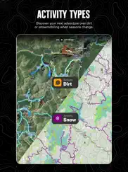
What is onx offroad: trail maps & gps app? GPS mapping App that lets you easily find the off-road trails you're looking for—whether you want to discover what’s open nearby or explore somewhere new. Filter 615K miles of nationwide trails by accessibility for 4x4, SxS, dirt bikes, moto, ATV/Quads, Overland, and snowmobiles.
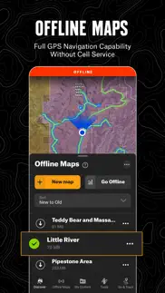
▶Navigate Without Cell Coverage
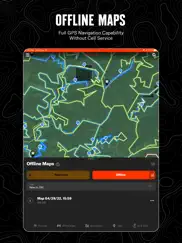
Save Offline Maps to bring your custom maps and adventure along when you're outside cell coverage on the trail. With the onX Offroad App, you turn your phone into a handheld GPS device using your phone's internal GPS. Navigate offline by following the blue dot to always know how to get home–wherever home is that night.
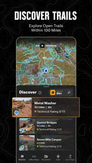
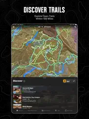
▶Adventure is Tap Away with Our Library of Map Data
With map data sourced from USFS, MVUM, BLM, and NPS, our color-coded basemap includes off-road trails, Public Land boundaries, and recreation points to let you quickly scan for open routes near you and locate dispersed camping or campgrounds. Tap anywhere on the map to find hiking trailheads, trailer parking, non-ethanol fuel stations, boat launches, fishing access, and more. Scout the landscape and visualize mountains by viewing your maps in 3D, topo, satellite imagery, or a hybrid.
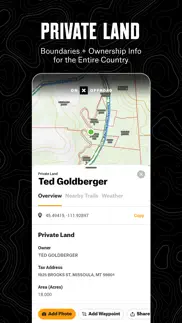
▶Private Property Maps With Boundaries-Elite Only
Make your maps Elite to discover more off-road access with private property boundaries and data for the whole country. Always know where you can legally off-road and camp, and find out who owns OHV trails or the property next to a trail easement with our Private Land Map Layer.
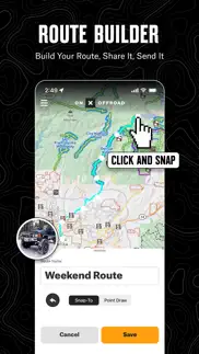
▶Plan, Record, Save, and Share Your Trips
Drop Waypoints to save points of interest on you maps and share locations with others. Go and Track records and saves your speed, distance, location, and leaves a breadcrumb trail so you’ll always find your way back and can share your ride with friends and family.
▶Off-Road Trails In Your Vehicle’s Dash
Carplay compatibility lets you enjoy hands-free navigation and view off road trails and maps in-dash.
▶ PREMIUM AND ELITE OFFROAD APP FEATURES:
▶Private Land Layer-ELITE ONLY: Nationwide private property maps and land boundaries, ownership information, and acreage
▶985 million acres of Public Land across the U.S.
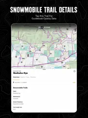
▶615,000+ miles of motorized roads and trails off-road for 4x4, Side-by-Side, dirtbikes, dual sport,, ATV, Quads, Overlanding, and snowmobiling
▶24K topographic maps and 3D maps for the entire U.S.
▶550,000 Recreation Icons for points of interest including:
▶Gas / non-ethanol fuel stations
▶Trailer parking
▶ Backcountry cabins and lookouts
▶Swimming and fishing access
▶Hiking and biking trail heads
▶Designated camping areas, campsites, campgrounds
▶Hot Springs, Breweries, and much more
▶Save unlimited Offline Maps for offline navigation without cell service
▶Mark points along your route with photo Waypoints to plan and share your adventures.
▶Track your trips (location, speed, distance, and elevation) to know where you came from, how to get back, and share your ride with friends.
▶Locate free camping, car camping, and dispersed camping
▶Active and historic wildfire layer to help plan safe adventures
▶ Localized weather conditions and 7-day weather forecasts
▶Line, distance, and area measuring tools
▶Coordinates and compass for anywhere you scroll or roll
▶ TERMS OF USE:
https://www.onxmaps.com/tou
▶ FEEDBACK:
At onX it’s our mission to help you find new places to explore with confidence, knowing you have onX Offroad with you.
If you have any trouble or have an idea on what you’d like to see in the app next, please contact us at support@onxmaps.com. We’d love to hear from you.
😍 Do you love OnX Offroad: Trail Maps & GPS app? Please share your friends!

Please wait! OnX Offroad: Trail Maps & GPS app comments loading...
OnX Offroad: Trail Maps & GPS 24.9.0 Tips, Tricks, Cheats and Rules
What do you think of the OnX Offroad: Trail Maps & GPS app? Can you share your complaints, experiences, or thoughts about the application with OnXmaps, Inc. and other users?
OnX Offroad: Trail Maps & GPS 24.9.0 Apps Screenshots & Images
OnX Offroad: Trail Maps & GPS iphone, ipad, apple watch and apple tv screenshot images, pictures.
| Language | English |
| Price | Free |
| Adult Rating | 4+ years and older |
| Current Version | 24.9.0 |
| Play Store | com.mtmapping.onxoffroad |
| Compatibility | iOS 15.0 or later |
OnX Offroad: Trail Maps & GPS (Versiyon 24.9.0) Install & Download
The application OnX Offroad: Trail Maps & GPS was published in the category Navigation on 04 November 2019, Monday and was developed by OnXmaps, Inc. [Developer ID: 636558832]. This program file size is 401.72 MB. This app has been rated by 5,226 users and has a rating of 4.3 out of 5. OnX Offroad: Trail Maps & GPS - Navigation app posted on 18 March 2024, Monday current version is 24.9.0 and works well on iOS 15.0 and higher versions. Google Play ID: com.mtmapping.onxoffroad. Languages supported by the app:
EN Download & Install Now!| App Name | Score | Comments | Price |
| Go Adventure Watch Reviews | 5 | 1 | Free |
| OnX Backcountry Trail Maps GPS Reviews | 4.6 | 1,889 | Free |
We have been working under the hood to make sure onX Offroad is ready for your next big adventure. This version marks the end of support for iOS 15, so make sure your device is up to date to continue to receive all updates of onX Offroad!
| App Name | Released |
| OnX Backcountry Trail Maps GPS | 09 December 2020 |
| Volta Charging | 11 June 2015 |
| Neshan Map | 04 May 2023 |
| EVgo EV Chargers | 17 October 2017 |
| Circuit Route Planner | 22 March 2017 |
Find on this site the customer service details of OnX Offroad: Trail Maps & GPS. Besides contact details, the page also offers a brief overview of the digital toy company.
| App Name | Released |
| Aprs.fi | 02 December 2015 |
| Tide Graph | 12 February 2019 |
| Exit Strategy NYC Subway Map | 07 July 2009 |
| Phoenix Zoo - ZooMap | 19 December 2021 |
| Cachly - Geocaching | 11 December 2015 |
Discover how specific cryptocurrencies work — and get a bit of each crypto to try out for yourself. Coinbase is the easiest place to buy and sell cryptocurrency. Sign up and get started today.
| App Name | Released |
| Google Chrome | 28 June 2012 |
| YouTube TV | 05 April 2017 |
| Google Maps | 12 December 2012 |
| BeReal. Your friends for real. | 08 January 2020 |
| Wizz - Make new friends | 24 February 2019 |
Looking for comprehensive training in Google Analytics 4? We've compiled the top paid and free GA4 courses available in 2024.
| App Name | Released |
| Earn to Die 2 | 20 November 2014 |
| Suika Game-Aladdin X | 06 March 2024 |
| Paprika Recipe Manager 3 | 15 November 2017 |
| TV Cast Pro for LG webOS | 23 June 2016 |
| Bloons TD 6 | 14 June 2018 |
Each capsule is packed with pure, high-potency nootropic nutrients. No pointless additives. Just 100% natural brainpower. Third-party tested and validated by the Clean Label Project.
Adsterra is the most preferred ad network for those looking for an alternative to AdSense. Adsterra is the ideal choice for new sites with low daily traffic. In order to advertise on the site in Adsterra, like other ad networks, a certain traffic limit, domain age, etc. is required. There are no strict rules.
The easy, affordable way to create your professional portfolio website, store, blog & client galleries. No coding needed. Try free now.
OnX Offroad: Trail Maps & GPS Comments & Reviews 2024
We transfer money over €4 billion every month. We enable individual and business accounts to save 4 million Euros on bank transfer fees. Want to send free money abroad or transfer money abroad for free? Free international money transfer!
Much improved - Still needs a little tweaking. OnX user for a few years now. Initially using it in conjunction with another gps/mapping program. OnX was not user friendly, glitchey, lacked a lot of features. OnX has changed that and is making great strides toward a robust system that could be the "standard" with a few more tweaks. Is much user friendly now, site navigation has improved as have a few features. One thing that keeps me toggling between OnX and the other huge program is the more data I develop in my OnX acct, the slower "log in" and saving/editing data is. Not sure if they are "throttling" to require subscription upgrades or if the system is getting overwhelmed on a whole. Additional tweaks moving forward- - Additional colors in the palette choice - The ability to actually "delete" not only hide OnX shared routes/tracks/waypoints - The ability to choose a few map "layers" to better observe info while developing pre-travel routes (zoomed in state line info, road numbers/names on top so they are not hidden under the route line, etc.
No navigation…. 1. I was frustrated to find out that there is no navigational aspect to this app. The reason I paid for a premium off-road app is to avoid buying an inconvenient GPS device. It seems like an obvious feature that is missing. It should be more intuitive to find a trail and then start directions, navigate from to and from your own waypoints. 2. The other major feature missing is the ability to favorite or pin trails. I can’t remember all the trails I find when I’m in the discover tab. You should be able to create lists and favorites so you can plan trips better. Overall, the app is decent but missing some glaring features. I’d love to be able to make this a go to app when I’m doing a Backcountry Discovery Route, but it’s just not there yet.
Discouraged with purchase. I paid the $30 for this app and it’s not great but just ok. Very frustrated that the first thing you see when you pay the $30 is that you should have paid the $99 if you actually want to use the app lol. I wouldn’t recommend this app unless you plan on paying the $99 and even then I’m not so sure it’s worth it. Especially since you have to pay $99 every year! Way too much money if you ask me. I will not be continuing my subscription next year. I live in Utah which is home to ATV and UTV trails and the first time I used the app I ended up in a dead end River bottom. I’m sure it’s not the apps fault but I wish it were user friendly and a way to see where you are on a map without cell service. This is useless when in the mountains. Maybe I should have paid the $30 and an additional $99 to have this feature??
Confidence builder. Great tool to have when your out in the desert everything begins to look the same out there and having that bird's eye view keeps you from making wrong decisions that could leave you out of fuel in the middle of nowhere. Certainly a must have in my opinion "safety first " let's all make it home safely. If I could make a suggestion to the future development of this app I would ask if they could add a "setting " to make the print and markings larger for us over 50 off-roaders even with reading glasses on out in the sunny desert very difficult to see even on iPhone 13 . Till then I may have to upgrade to an ipad?$$$
Landscape! Apple car play!. I have been using the app for over two years. Premium subscription. I use it for real while off-roading and overlanding. I do love it for this purpose. However, I beg of you to develop this to allow landscape orientation and plead for apple car play. I must use my iPad (so I can see it) and then must use it in portrait mode. Portrait mode does not work well with my vehicle setup. Landscape would be much better. But alas, Apple car play would be the best as it make use of the large screen I already have! Please make it so. I have started experimenting with other apps that are able to do this. OnX has everyone else beat except for this rather serious omission. Thanks!!
Nice app!. Overall this is a great app! Easy to use and it works well on an iPad. I have two issues that would be an easy fix. The iPad is mounted in landscape mode on the dash of my SxS. When I start OnX Off-road, it comes up in portrait mode (sideways) when the iPad is in landscape mode, and the iPad has to be unmounted from the dash, rotated around until the app flips to landscape mode, then remounted on the dash. Please have the app detect the mode of the iPad and start in the appropriate mode, landscape or portrait. The second issue is that when the app is in landscape mode, the menu selection and buttons disappear from the screen so you lose functionality. Please have a selectable option so people can choose to keep the menu and buttons on the screen in both landscape and portrait mode. Other than these two things, I really like the app and it works great for trail riding in my SxS. A nice feature to add would be crowdsourcing the trail info so the maps can be updated easily. There are several trails in my area that have changed and it would be nice to be able to ride the new trails and upload the data to be integrated back into the app.
Not sure of value. Downloaded this app to help find trails and dispersed campsites. Didn’t really help with that. Started looking at some trails I’m familiar with and it was lacking. It’s difficult to interpret the what all the dotted lines mean without going to search “Help” for the legend - not sure if I’ll have access to it when I’m off the grid. I was considering paying for the subscription, but based on the free version, the paid version better have a ton more content. Unfortunately I don’t know how much more content the paid version has and not sure I’m willing to pay to find out. App developers really should offer the premium version for 6-12mons for free while they continue to build on a potentially great app. If I knew exactly the quality of the content I was getting, I would have no problem paying for the subscription.
Landscape orientation not really supported.. I was told that the search function was not supposed to be supported while in landscape orientation. When you click the search button while in landscape mode, the app re-orient itself into portrait mode for you to enter text and then reverts back to landscape mode. Did nobody test this? Let me answer that, no. When I emailed customer service they told me that the search function was never supposed to Even be supported in landscape mode, and that it’s presence itself was a bug. Why would you support the iPad and yet get rid of an important feature in one of the two possible orientations not everybody uses this app in portrait mode, especially on an iPad. seems pretty obtuse. Wish I could get my money back for the subscription.
Amazing app!. This app is amazing. We rented some SxS’s for a trip up to the mountains in northern Arizona and finding user friendly maps thru the Forest Service websites is impossible. I stumbled upon this app and man am I so happy I did! I was immediately able to see all trails in our area and get detailed info on the trail itself. My fiancé is always afraid we will “get lost” out in the woods and it can make for stressful rides. However, with this app her fear was totally gone! We were EASILY able to track our trail on the map, follow the trails, see where we were, distance traveled, locate numerous trailheads and staging areas, see and find where trails met up, ect. We were pretty deep in the mountains and woods and we were 100% offline with no service and able to still easily see all this info with the freaking amazing ability to still use the trail maps and tracking while offline with no service. This app made our trip and our rides SO enjoyable. Thank you for the awesome app! Made our outings awesome! This is DEF a keeper. We will be using this every time we go riding for sure.
Rocken Off Road. Just like my onX hunting app that I have had for many years. I just purchased a newer Jeep and the off road app has a ton of options. And if you are smart enough to download a bunch of maps in the offline section. That way when and if you just so happen to get into an situation that you have no signal. In the offline mode you are able to use the app without even noticing that you are offline with no signal. It’s truly amazing what the app is able to do. Online or offline won’t make a difference!!! Definitely worth every penny!!! Specially if you spend any time off-road. And did I mention that the app will let you know who owns the land with contact info and property lines that are very accurate!!! And that is a valuable feature!!! Specially if there is someone that is trying to tell you that you are trespassing. And when you show them your onX app and the property owners name and contact info. And there jaw hits the ground. 😉🥸Lol. Or you look at your app and and catch the land owners name. You then ask them if they know such a suchs name. Then they assume that you know them. Well to rap this up. I can not say enough good things about this app and the onX hunting app!!! Be safe and have fun!!! 🛻🛻🛻🚔🚔🚔
It’s OK. There are a few things this app needs to be great - 1) have a way for users to report trails that are closed for whatever reason; 2) once you find a trail there is no way to get directions to the start/end of the trail - the app just locates the trail but then it leaves it up to you to find how to get to that trail - building in integration with Google/Apple Maps and/or Waze seems like it should be intuitive but it’s not; 3) there is no way to contact the developer or support in the app - there should be a way to provide this feedback right in the app instead of having to leave a review here to tell the developer. In any event, it seems like a solid app - didn’t crash and provided nice offline maps that you can set the area for to download so you can view them without any cell signal. Hopefully the developer can add the features above and if so I will update my review at that time.
Nah. Ive been (trying too) use/using this app for a little while now. Im a paid subscriber. It was working great up in smaller national forests but im currently on a trip through some pretty large forests with LOTS of trails and its been bricking the app. Freezes every 3 seconds for 5+seconds. Makes trying to locate a new trail impossible .i thought maybe downloading the map area for offline use would fix this but NAH , still does the same. Honestly i think it has to do with the “in your area” feature trying to populate all the trails, but who knows. Really frustrating when i see an area i want to check out but its rake 20 minutes of freezing/stopping/crashing and having to use competitor apps along with this slow one to ultimately use my physical map to get the same/better info. TLDR; app is buggy, freezes and ultimately provides a frustrating solution to something a printed map does.
I’ve TRIED THEM ALL. I have used ONX for over a year and after using other apps this is my first choice. The best thing about it is the newest update that rates each trail and road by using color coding. While using another app I was led unknowingly into a trail near Moab, Utah called Pritchett Canyon. This trail is WAY beyond my skill level and I was very lucky to get through uninjured. With ONX the same trail is clearly marked in red which tells me it is extreme. On the other app it was indicated exactly the same as the road I traveled on with my motorhome, so I had no way to know how extreme it was. This kind of mistake will never happen while using ONX. I am a happy user of ONX forever. The customer service is also great. They have a phone number on their site,(unlike most other apps), and you speak to a real person almost as soon as it rings. This is a great app well worth the money.
Great for trip planning!. I have used and I’m well versed with onX and Gaia. onX is much better for trip planning because it has so much more information when I’m at home with internet access, planning the routes and points of interest for our events. I do wish that there was an easier way to save map data for offline access or that it would not require internet access to have it while I’m en route. If I don’t download the appropriate area or zoom down to the level of detail or end up wandering outside of the area that I planned, then I have no map data. That is my only request to onXmaps, but other than that, it’s a great product.
Fantastic Off Road and beyond Navigation Tool. Very intuitive approach to on the fly on and off road navigation. Super easy to find trailheads, trip planning and quick bullet point data on the surrounding area. I will be using this tool extensively for a two month brand photography tour across the western half of the United States. Currently planning out camping permits - very easy to make notes via waypoints in back country areas inside the national forestry park system. Agency numbers, filing permits, fire roads, private lands, routing data, etc. All encompassed in a one-look graphic interface. No more chasing devices and maps - all off or online. Paired with a Garmin GPS, this is one stop shopping for all things navigation, camping, route data, contact reference. They are currently working on improved “cake and eat it too” map interface improvements re more layers, quick toggling on/off for even better quick field reference. And other wish list items. Glad I found this wonderful tool and looking forward to riding with it soon . . . Happy trails!
Very useful app. I’ve been using PDF maps for years with great success, but this year I started using OnX Offroad as well and the more I use it the more I like it. Being able to filter trails by vehicle type is really nice plus new trails and features are being added almost daily. The new 3D option is killer. I just did a recent trip to Moab and used OnX exclusively and found some really fun trails and less than well known routes that I had never been on before making it one of the best times I’ve had in Moab. We are headed to Saint George in a month and will be testing it down there as well even though we know the area fairly well.
Very flawed. You are unable to delete an import of waypoints making it completely useless to me. Their support told me I would have to delete each waypoint I imported ONE BY ONE in order to not exceed their waypoint limit. I can’t import anything anymore and deleting each waypoint one by one would take over 60 hours of my time the way this is designed. What useless software and terrible support service. I cancelled my subscription immediately and hope something better comes along. UPDATE: the suggestion in the reply to this review would mass delete important markers from my personal research and is not a viable solution. I’m sorry body can fix this and that it is designed in this way. I need someone to simply delete one large import I made, not delete everything. Fix your software. Add a warning that says are you sure you want to import xxxx waypoints, it exceeds our max and it will break your account.
Closed Trails not closed on app. I use OnX off-road exclusively when riding in Western Arkansas as well as for hunting. This deer season, I travel down a road/trail that is on OnX maps, as I had for years. This road is now closed; with NO closure sign, gate or earthen mound. I parked and proceeded to hunt. I received a $230 fine for having my SXS on this trail. I showed the officer the map, he said it’s the wrong map. I showed him the road is not closed on Avenza either, nor on the Forest service map that I carry. The US Forest Service Officer stated that the only up to date map is the MVUMs (motor vehicle usage maps). ONX-off-road and Hunt apps need to ensure their customers are provided with the most up to date and reliable maps. They should ensure that they are using the appropriate MVUM or have a KEY to show which trails have been verified to be open and which have not. Otherwise there’s no real reason to pay for an app that is gonna lead you down a trail to a $230 fine.
Best overland platform. Today I got back from a multi-day overland trip that took place near San Diego, CA. I used this app to plan the entire route for the trip as well as to see where I was going. The fact that it has thousands of trails already marked makes it very easy to plan a route. Many trails even have a ton of information about them included when you tap them. Even when there’s trails not ‘officially’ marked, it still has most marked as single/dual tracks. You can add different types of markers and waypoints when planning a long trip, which is very useful as they can become very clustered sometimes. Downloading offline maps has never been easier as well. Just pick an area on the map and boom. In my opinion, best off-road/overland maps platform out there. Far easier to use than popular competitors. Definitely made the annual subscription worth it!
Well Done! Please don’t change a thing!. I absolutely love this app! I have tried many, but always yearned for an app that was simple to use and stable. I believe you nailed it! It’s not overly complicated, very user friendly and does not crash when using it! It allows you to enjoy the adventure with minimal input. I love the discover feature… the only thing I would add would be a feature that allows you to sort the nearby trails by difficulty rating. Also, it’s a little hard to tell the difference of your trail lines; 50” vs high clearance vs dirt bike etc (would be easier if you just color coded them different bright colors) Regardless, well done onX! Very well done indeed!
This app saved our bacon!. We went looking for a particular trail in Southern California, and could not find the trailhead so downloaded this app. We proceeded to drive at least four hours in. Then the real problem came. No cell service and trails going every which way. No idea how to get back and no one around. Getting dark and cold. Another rig rolled down the cliff, laying on its side. Nobody in it. Scared the —- out of us. This app put a blue line on the map, just like we were navigating to Starbucks in town! Rookie mistake by a self proclaimed rookie, but I would highly recommend that you download this before you go exploring. Our bodies would probably still be out there being eaten by birds if I didn’t have it! :-) I don’t know if there are other similar options, but this one works great for me, so I’m keeping it!
Hire a UX designer and I will pay for this. This app is one of the most awful apps from UX perspective. Functionality is great with nice maps but I am paying for Alltrails over this because of how awfully this works. If they would fix this I would swtich as this has slighly better maps for offline 4x4. But till that.. I am not paying for a company cheap enough not to hire designers. E.g. going into search mode takes almost a minute (On Ipad), search results are not sorted and I cannot sort. Cannot search for trails but roads only then I have to click on the road - show nearby trails. I cannot hide annoying temperatures. I set metric units and still see Farenheit. So few options when search (free text and thats is). 2 stars for the great maps and the community who is uploading photos and reviews (not that big) at least in my area.
So far so good. A few things though.. So far so good. Been using this almost every weekend here in Colorado on OHV trails and it’s been great. A few things, first I wish there were more pictures of trails so that I didnt have to jump back and forth between AllTrails and OnX in order to get a good idea of trail conditions. Also, the ability to get directions to trails. When you click on directions on AllTrails it will kick you over to your mapping app and automatically input the coordinates and give you directions to trailhead. So, something like that would be sweet. Lastly, I wish it had compatibility with Car Play. It would be really nice to see OnX on my trucks screen instead of having to keep my phone out. Other than that this is an awesome resource to have. Great work!
Works great!!. Side by Side adventure in the mountains of western Arkansas with buddies where there was barely if any signal at times! Some of the guys had other location/trail apps that worked but didn’t show all the trails we were on and didn’t work most times with no signal. OnXoffroad worked every time on the dot! Update: Words above are still true, but doing some looking around at trails in different states that I’m planning on going, the marked trails, green, red/orange, blues some multiple colors on top of each other. There needs to be something in the app telling what that means like a map legend or something. I still love the app don’t get me wrong. Now I have clicked on the different color trails and best I can figure out there are certain dates they are open but still confusing. Guess it doesn’t matter to much because when I do get to get to these areas I’m wanting to go if it’s open it’s open. Just think the app is great showing right where you are even with no signal.
Almost perfect. I’ve sold this app to soooo many people, I should be getting commission! I absolutely love it. We’ve explored so many new places we would have never known existed without this app. I wish I could give it 5 stars, but you gotta fix this problem: I’m going out on a limb here and guessing most people are using this app on a iPhone or iPad. I’m also guessing most people mount those devices sideways, especially considering most mounts will only take the device sideways. That is where the app needs help. For me, as soon a I “Record My Track” and secure my iPad in its mount (sideways), my track is off, it shows me pointing in a different direction, and lags. Following the route becomes confusing. PLEASE FIX THIS! Like I said, I love this app. I’ve tried several others, and this one is by far the best.
Not what I expected.. First off. It claimed to be $8.99 and month. When I checked out it charged me the full $100 for the year. I would have like to try it out before purchasing. It doesn’t show the difficulty levels of the trails like the popular apps. It shows rivers and streams as trails witch will mess you up. I’ve had to turn around and regroup because of the lack of info several times. This is one for he most rode in places in the southeast. “ wind ridge” 70,000 acres In Tennessee. It’s just a half developed app in my opinion. Had I have had the luxury to try it out before paying the full membership for the year I would have chosen a different map. I’m going to try one more trip with this but I’ll probably wind up buy one of there competitors apps based off what I’ve found so far. Just not with what they ask for in membership fees. 🙄
Great tool for off-roading. Bought the app and haven’t been more happy with a trail map. Offline downloading works nice. Being able to pin locations and color coordinate is a big help. Plus the trails mapped out are really easy to see and plan a route. It is still a decent idea to have Gaia to cross reference with with a Nat geo map to see if a trail is gated or is actually accessible. Love that there are updates coming out with additional trails and info for areas. Very nice that the community can add photos and recent trail conditions to maps out trails so anyone looking to do popular trails and research before planning a trip. Only thing I’m hoping to see be added is the ability for the app to be used on a CarPlay radio. Currently just have it on my phone mounted to by dash but if it could be on the radio would be very convenient. Still a 10/10 app and wouldn’t be able to explore as much without it and know I’m going somewhere I won’t be let down by.
Used in Multiple states for work and play. I travel a lot for work using a variety of vehicles to get into back country areas on public land. I use onX off-road and hunt to know what I am getting into so I don’t break my equipment. I also am an avid off-roader in my personal time and have used onX off-road in 16 different states and have enjoyed the info that they provide when I get to a new area. They give me the confidence when I get to a new place about what trails I can hit without having to track down all the local knowledge before getting out on the trails. I look forward to using onX in the future. I would like to see a way to link accounts across hunt and off-road along with having a way local off-road clubs could add contact info (if they are willing) so folks new to the area could reach out with questions.
Good summer and winter. Been using the app a good 3 years now both summer and winter. It's pretty good with forest roads I would say over 95 percent of the time it's right on. I ran into few times it's off or trail not on it. The tracking feature is great when in new area that has a lot of off shoots and most of the forest roads are not marked or not readable. I use it in winter time too with the snow machine on my iPad , only issues is keeping it warm enough since cold will kill the battery fast. Always have a back up like paper maps since it's limited to electronic that can fall...had it happen but was able to backtrack from where we were at. The way point feature is nice too I can mark certain locations and add a picture, that way can always come back to that spot quicker. I have the hunt app and use that too and add picture of whatever I scouting or just want to remember where that bear or buck or bull elk was.
Overall great content but…. Love the app. Took a little time to understand how to navigate the app, however once you get the hang of it it’s great. I’ve had the app for a while now. After they came out with the “premium” membership though they withdrew a few abilities that the original basic membership had for the entire life of the app. Felt like the basic membership was steep but for the the whole app included, I was pleased with the product. Can’t say the same thing now with the adjusted membership classes. Would’ve been a lot better for users to keep original tools perks and all and create new perks for premium rather than swipe from already paying original members.
BEST 4x4 TRAIL MAP/APP I'VE EVER USED. Over the last couple of years I have used a few different apps and dashboard GPS units, and OnX Offroad IS BY FAR THE BEST! The trail detail/information is great - every off-road trail i've looked for is there, with additional information such as difficulty, etc.. Even the extreme trails are there.. The satellite imagery is incredible, the mapping tools are simple to use and the ability to view/edit/create routes on my iPhone, my ipad, or my computer and have them all sync'd is great.. The ONLY thing this app lacks is Apple Carplay compatibility.. If it was Carplay capable and I could view the map on my in-dash Carplay head-unit, this app would literally be the best thing since fizzy beer. So until then, it's only the best thing since sliced bread. Seriously.. I am very happy with this app.
Seems good needs improvements. The App seems to function well in vertical mode on a device in horizontal mode it’s like all GPS apps, you lose 90% of the functionality. Most people that use these off-road for side by siding especially people with a Can-Am Maverick x3 with a factory tablet hold. We know that the tablet is meant to be in the horizontal position. With this app like many, you can not touch a waypoint you have already set and get the info or drop down. You lose the function bar at the bottom in horizontal view that you see in the Vertical view. I think If you change or rotate the device I think the app should stay the same. Kind of disappointed because I paid the money to use this in our SXS and the functionality is gone how we intended to use it. The device we have iPad 10.5 will not fit in the tablet holder in the vertical position. Please if you can change this and I would be willing to re-rate my review. Also are you planning on a snowmobile version of this? Thanks.
Incredibly useful tool BUT. Complaint: While recording tracks, the app would crash constantly. You could usually pick up where you left off, but occasionally all your progress would be lost. That being my only complaint, I have used this app every time I go out exploring. I use the version that shows land owners which is helpful while trying to find dispersed camping. The offline maps work beautifully and I’ve found some INCREDIBLE spots to camp for a night. Suggestion: I also like being able to post updated reviews of OHV trails and forest service roads, but I wish I could share publicly when there’s a closed gate or other barrier. This would have saved me countless miles on some trips. Consider implementing a user-dependent feature (like WAZE does for reporting stalled vehicles or the 5-0) that allows us to share closed gates, barriers, or flooded/impassable water crossings and when other users come up on the area they can confirm that it is still closed, or is instead open. OnX has proven to be an invaluable tool thus far and I’m happy to continue with my subscription. I’m hoping to have many more safe and successful adventures with its use!
Have confidence in where your going!!!. I love this app. I have been using it since they first released it and it has never let me down. I was invited out to the Mojave Desert for a few days of wheeling and I couldn’t turn it down. I had to meet the group up later on due to work schedule, but that wasn’t stopping me from going out there alone. You see I had the OnX app. We took off into the night just my dog and I, to find the group on the outer edge of the preservation. We found them no sweat and set up camp for the night. The following day, the group organizers were explaining to everyone a few of the do’s and don’ts for the trip. I came to realize about 80 percent of the convoy had no idea where we were going. It was an amazing feeling to be able to have the confidence to know where I was going. It was miles of empty desert in every direction. It’s intimidating when you don’t know your bearings and everything looks the same. With the onXoffroad app there was no worry of getting lost. Another great feature is the ability to record your location and the exact trail or path you drove. If you need to double back to the beginning. Or if you enjoyed the trip that much, you can always go right back to where you started. This app is definitely worth the money if you regularly hit the dirt. FOLLOW FULLSENDCHEVYS on INSTAGRAM!!!!
Fix what you guys have done. OnX has been nothing short of the greatest app on my phone. I use it for hiking, backpacking, off-roading, and camping. It has the best detail and all of its features are great. I basically have all of Northern Arizona downloaded and it’s works great so I’m never lost. I would have given five stars but since the new update the app has basically become useless. I normally wouldn’t be to upset but since I’m paying $100 a year on an app it’s pretty frustrating. Now if I try to zoom in or out while I’m tracking myself then the app resets and instantly exits back to the Home Screen. Also like I said I have Northern az downloaded. That used to work all the time. But now that only works if I’m in airplane mode. Even though I have everything downloaded, none of it will load unless I’m offline which makes it difficult to run other apps simultaneously. None of these issues were happening prior to the update. Like I said earlier, I still love OnX. The people and the support are incredible. But what ever they did in the most recent update is pretty disappointing because the app is essentially unusable currently.
Best use of money.. I’m a big map guy and used to work in the GIS industry, so I was skeptical before I started my trial of the quality of geospatial data they have. I’m quite nit picky when it comes to paying for apps, but this the only subscription I’ve ever paid for an app for my phone. It has a huge array of helpful features, and it’s obvious from using it that the people who worked on this app truly care about making it the best experience possible for the user. I hadn’t even finished my 7 day trial yet before I decided to purchase the subscription. I haven’t used it outside of FL yet, but so far the quality of data is quite high. This app is definitely a must-have for off-roading.
OnX Off road is awesome for adventures. I bought a Jeep last year to get out and see more of the wilderness. I couldn’t find where to go I looked on google maps to try and find trails with little to no luck. A buddy said try this app. Let me tell you this app has pointed me in the right directions I have found so many new places to explore and check out. The pictures and difficulty rating made it a breeze to find places to go. You can also share places and trails you have been on with friends or Facebook just about to anyone. I would recommend this app to any one looking to explore the outdoors. Thanks OnX for the adventures.
Potentially a great app!!!. I used OnX Hunt for two years now and love how it works for hunting. Never had any gripes. This app is almost a pure copy of that app but..... That's not a good thing. Needs a few tweaks that cater to the off-roader. Also this is going to stir up some controversy in the riding communities. I live in Michigan. I am looking for a good app for snowmobile trails. When I get on the app you have all the snowmobiling trails labeled well on there but when I sort by rides there is nothing labeled for snowmobiling just all sorts of wheeled vehicles. And in Michigan most snowmobile trails are actually closed to ATV/SxS/ wheeled vehicles. And vice versa for snowmobiles on ATV trails. If someone didn't know any better a person using this app could ride on those trails when they aren't supposed to and risk angering property owners that could revoke access to those trails. Next thing you need is a better layer sorting system here. The hairline dashed trail lines are difficult to see and even more difficult when out on the trails in bright sunlight. I think giving an option to change the lineweight/thickness and color would be a good bet. And if that is too complicated for coding purposes maybe just select a more bold and brightly colored line. I think you guys are on to something great as having a membership for one app that can do all these different hobbies is awesome. Keep up the good work this is on the right path.
Great app.. This has been a great. I travel cross country as a National Park Service employee. Instead of paying 100+ dollars per night at a hotel, I like to camp between my summer destinations. This app allows me to find a legal and out of the way place to camp both in both my travels to different parks, and during the months I’m working at those parks. I also have the paid version of Gaia GPS. Gaia GPS is also a great app and a little cheeper but onX Overland offers way more and is a little more up to date. You can creat waypoints, filter out trails that your vehicle definitely won’t go on, and plan entire trips with ease. The few gripes I have about this app is not every trail has photos of the trail and it’s a bit expensive. With that said the positives of this app definitely out weigh the negatives. If you travel a lot and prefer camping over hotels, or you just like adventures and getting out on the trail, then this is the app for you.
Release your inner offroader. I got this app a year ago, and absolutely love it, I use it all the time in my personal life and sometimes even at work. The integrated private land plat is a fantastic feature for my research and planning for my general exploring, especially in the midwest where public land is scarce, and you have to find cool rough county roads that are designated public via the plat lines. There is a few features the app could have moving forward but in the year I've been using the app and talking with support and development, they are very focused on refining the app at all times. At the end of the day they are offroaders at heart too and want other offroaders to find success and fun outdoors, the bonus for them is that you use their app to help you get there, but that bonus is mutual because it is a valuable tool. This app will save a day or two a long the way if you use it long enough, I went to a trail in the East TN Appalachian Mtns. and the first choice I went to was closed (Hope they add a check in feature to help prevent this later on down the road, I believe they will). So I pulled up the app found another trail within 10 miles away, rerouted and still enjoyed my day offroading, there was very little service in this area too and the offline map I saved of the area backed me up and made sure I still made it despite the bad service. If you intend to offroad anywhere from a handful of times a year to every weekend or even more, On X is worth having.
Lacking for Offroad use. I use this app weekly for property information. But as my title says it’s lacking for Offroad use. Almost every “trail” and “trail report” that is shown within 100 miles of me is nothing but an average forest service road that you can drive your families minivan down. The frustrating part is that many of these “trail reports” pass through actual OHV areas with real trails. For example in the Yacolt Burn State Forest the L-1500, L-1200, and the L-1100 roads have reports on them. Yet none of the 4x4 or ATV trails have any information. Once again in Hood River County the routs that are marked are nothing more then forest service roads. Yet the actual Offroad trails have no information. Then there’s the “Tillamook Loop” in The Tillamook State Forest in NW Oregon. The so called Tillamook Loop consists of multiple named 4x4 trails with varying degrees of difficulty. Yet this trail report calls it a 6 out of 10. Many of these are far easier then a 6 rating and then there’s a hand full of trails that should have a rating of an 8 or above. But they’ve all been lumped in together with an average rating that doesn’t represent what you will actually be getting into. As I said at the beginning I use this app weekly for property and land ownership information. But I do not trust it when it comes to anything about trail information. Daryl Keenan
Very impressed, but missing a few features. I have been using OnX Off-Road for a year now (Premium), and it has been a great tool for both navigation and trip planning. The map downloading works flawlessly, and the growing list of marked off-road excursions makes it fantastic for finding great spots. Living in the NorthEast, fun trails can be hard to come by, but even in the past year, lots more have been popping up. The photos and description of the trails is great for sizing up your ride. My biggest gripe about the app (which is minor) is that the search function is not very effective. You can find specific locations (coordinates, towns, names of trails or campsites). It would be great if you could search all of the campsites, waterfalls, or gas stations, etc. in a certain area, and they would be highlighted and compiled into a list. This would help out when planning a ride. Instead, I currently use other apps or maps to find these spots, then add waypoints in OnX. All in all, fantastic app that is an affordable and effective way of navigating in the backcountry and finding awesome spots that match your skill level and off-road setup.
Amazing tools!. We have been using OnX for a couple of years now. The features are simply amazing!!! The ability to import and export tracks and waypoint, as well as organize and share them is invaluable. Going on a trail ride with dozens of other people is easy Peezy with the tools provided in this app. Want to create a route that doesn’t exist? There’s a route builder for that. want to style and distinguish your waypoint and then filter on them? There’s a tool for that too… You can add your own images for sites, hide and show features as desired, and seamlessly sync across multiple devices and platforms. Features and their support staff go above and beyond. Highly recommended!
Almost perfect for my Enduro riding. A great app for exploring and recording tracks. I wish it had an auto-pause feature as I like to know my accurate riding time. I’d give this 4.5 stars, 5 stars with auto-pause and some minor tweaks below. Maps are clear and you can select area to download for offline use. It’s been really solid so far. I really like all of the existing trails that are pre-loaded making exploring a bit more safe knowing where the next out point is. This is why I switched to OnX from REVER. I’d also love to see the ability to display speed when position my phone in Landscape orientation. This is only available in standard orientation for some reason. I like to run my phone sideways on my enduro bike over the bars to keep it out of the way a bit more (quadlock case and mount). Some of the touch points on the screen are too close to one another (particularly in landscape) which can cause issues when using gloves. It’s too easy to make mistakes when using the app because of this it can lead to a deleted ride.
Off-road? What’s even off-road here?. I’m really not seeing a way to filter out all the highway registered vehicle “off-roading” roads. Pretty frustrating to say the least that I’ve paid for an app that, in theory, should be able to tell me trails on the map I can actually take my side by side on and not get in trouble. I wanted to take my 4 day weekend and venture beyond the areas I am familiar with. I’m zooming in to click on every part of a “trail” that’s broken up into half mile pieces. A complete headache and waste of my time. And scroll through all the supposed information you provide only to find most of the “trails” you show on the map are in fact roads only open to highway licensed vehicles if it even has that information listed. In spite of the fact that it also shows that the same “trail” is accessible by dirtbike, sxs, quads. I think it is incredibly deceptive to market this as an off-roading app and not give the user the ability to filter for actual off-road trails for off-road machines. Which I thought was a reasonable expectation on my part. Also, pretty expensive subscription for an app. You got this chumps change, but not again.
Streamline!. Seamlessly perfect! Clear, precise and very well built! Teaching women to off-road and leading trail rides across our beautiful country is not easy to map out, this makes it seamlessly perfect for gatherings on the trails, the ability to share the trail meet up points, and trail ride from start to finish is amazing! Having folders of past trips to share with all those that join you is great! And being able to look back and say wow there are hundreds of miles highlighted completed trails is an accomplishment in itself! Very great full for this company all it does and all I can do using the app! Thank you so much!
Pay for it if you ride new areas a lot!!. I downloaded this app in order to find new trails and after finding a trail system my Fiancée and I went out the next day. After getting my ATV unloaded I opened this app and hit track just to see how long and far our ride would be. I’m glad I did! After riding for about two hours and taking a lot of different turns I realized I was (just a little) lost. I pulled my phone out and thanks to the offline map save and tracking feature I was able to follow my track the whole way back to out starting point. Highly recommend this app and for only $35 a year the offline maps and tracking feature is well worth it!
Awesome OffRoad Mapping Product!. I have been using the OnX OffRoad Map app for a couple of years and after using other map products I am totally convinced this is the best. Creating ride plans and camp destinations has been much more efficient using OnX OffRoad. Setting waypoints and establishing colored routes has been a huge benefit. Sharing my rides and tracks has assisted in helping others arrive at the same specific destination taking prescribed routes has helped assure those traveling with us arrive at the same specific destination at their own pace or at their desired time. The ability to create folders with the names of specific POIs or camp spots makes returning a breeze as all the POI, tracks and waypoints all live in theses specific only to that event folders. I highly RE on end this product!
Used to love it. I used onx off-road for almost 2 years had multiple offline maps and a couple hundred pinned locations and I used the monthly subscription which was one of the reasons I went with onx in the first place and I had no complaints up until a few months ago I noticed I couldn’t use my offline maps or create more updated the app still didn’t work well I went on with my trip in hopes I didn’t lose service and figured I’d deal with it when I got home and forgot about it a couple months goes by and I go to use it again and same thing so I reach out to customer service and they let me know they quit doing the monthly subscription so apparently they just don’t let anyone know and continue to charge them. Well the guy was doing his best to help me fix my account he said they gave me a free year which still never showed up so he told me the best thing would be to start a new account with a different email. Which I would then lose all the data I had saved which I get it I can’t count on it forever just a little shady to me to end a subscription yet still charge people. For the price of the yearly subscription I’d just go with Gaia GPS same price if not cheaper and way more features! Sorry onx
Always come back to ONXoffroad. I have a sxs rmax with a adventure pro nav and I still use this app . I download the offline maps and use them all over the plumas and Tahoe forests. I also use this on my phone mounted on my ktm 500 dual sport and it has not failed me yet, I ride all over and usually in the middle of nowhere deep single track and it works great for recording to share my rides and to get back safe, just figured out how to preplan rides and can color the track so it’s easier to read when mounted on my bars. It’s a great app just wished more people around here would publish there rides.
Did you know that you can earn 25 USD from our site just by registering? Get $25 for free by joining Payoneer!
Imagine you at your best. All the time. Picture yourself at your sharpest and most productive. Your most alert and focused. Your most lucid, creative and confident. At work. At play. In every area of your life. Add Mind Lab Pro® v4.0 to your daily routine and uncap your true potential. Buy Now!
Not great at all. Awesome that it’s in Canada now but there’s no point because there are no data or trails on it. I guess they expect you to map it for them. Kinda defeats the purpose of downloading it to find trails and such.
Great for dirtbiking. I was able to download my entire dirtbiking area and it only took up 1 gigabyte! Love this app and i would have gotten lost many times without it😁
to high a frustration quotient for me. on the surface, this appears to be a valuable addition for anyone's navigation and planning portfolio. but try to use it and it becomes something very different. does not accept that i have subscribed and i constantly need to refresh. constantly nagging for me to upgrade to elite. turns out maps in canada need an elite subscription anyway. i usually allow an app a couple of strikes before i toast them. 3 strikes in 20mins and i'm done
Change your logo…. Sometimes I accidentally open Twitter as you both have nearly identical logos - and I despise Twitter but keep it because, well, im not too sure why...
Finally in Canada!. It has taken some time for the app to become available in our store. The small temperature indicators on the map still display values in Fahrenheit instead of Celsius though. Feature requests: 1. Ability to view and manage users with access to a shared folder. 2. Integration with third-party maps, such as BRMB. 3. Option to download the entire screen or region as offline maps instead of selecting specific areas (tons of small rectangles…). 4. The capability to hide trails recorded by other users on the map and display only my own content.
Yeah, no. Stick with Gaia gps. Especially here in Canada. Many more map layers and easier to use. Just because some “overland influencers” use it doesn’t make it better.
Adsterra is the most preferred ad network for those looking for an alternative to AdSense. Adsterra is the ideal choice for new sites with low daily traffic. In order to advertise on the site in Adsterra, like other ad networks, a certain traffic limit, domain age, etc. is required. There are no strict rules. Sign up!
Awesome app with a few quirky things. First off I am loving this app and it integration into my trucks CarPlay. But there are a few things that I would like to see addressed in future updates. One is that pinch to zoom does not center on my fingers in any orientation. Every basic navigational map app I have does this except of ONX. The second is that I would like to have access to menus and options on the horizontal orientation. It’s annoying that I have to rotate my device to get access to my content, tools and offline map data.
Don’t be fooled!!!. I was tricked into spending money on this app. Don’t do it. There are other services that work the same or better for no cost. It crashes constantly when I try to track a ride. By spending money with them it was a license for them to spam my email with adds to upgrade or purchase OnX hunt. I was getting at least 1 spam email from them a day. Initially the app worked great, but now it crashes every 10-ish minutes on any ride and has become completely useless! Initially I liked the app, even with its quirky UI, so much so that I decided to spend the money. Since I did that, the app has turned to hot garbage! I have to use a different app now since it won’t run on my iphone 13! Stay away!
Hard to find trails, but great for navigating.. Pros: The offline maps are great! Being able to see land owners, boundaries, create routes, save waypoints, etc. is incredibly useful. This is the only app I use when I’m off-road. Cons: There need to be more filter options. Being able to filter by difficulty and trail length would be a game changer. But without it there are an overwhelming number of trails to pick from, to the point that it’s hard to find what you’re looking for when you’re looking for something new to try. I still use All Trails and Google but neither compare to what this app would be with better filters.
Great, but.... This is probably my favorite off road app so far. I’ve paid for AllTrails and Gaia but they tend to suggest hiking trails and I end up places I don’t want to be. This is just off-road vehicle trails! There are trails in my area that are not on this app however. But these trails are not listed on any app. ;) I do have a suggestion for improvement: the app will not stay open. After a few moments of not touching it it allows the phone to go to sleep. For a map while I’m driving I’d prefer the map to remain open without me having to take my hands off the wheel.
Most trusted trail app. We have put over 6000 miles on our SxS in the last two years and even though it comes with a competitor app installed in the dash we have installed an iPad above that screen and that is our primary navigation app. The new route planning tool is extremely nice and being able to use it out in the field to plan a new route in the route you had intended to travel is blocked is a great aid. This is definitely worth the subscription fee.
Useful in industry. This application allows our staff to have offline maps accurate to a few yards to find navigable routes for remote work and finding historical trails to minimize impact and brush interaction in wilderness areas, vegetated terrain, and regularly morphing drainage channels. This application has helped me get out of some pretty nasty situations of being in the field and needing to find the most downhill route. What’s better is it allows for fun on the weekends — that’s worth it and pays for itself if your work is in a similar vein.
This made our trip amazing!. We would have been lost without this app! ~We were riding ( atv) on mountain trails in Wyoming, and could see exactly where we were going and where we would end up. Where a trail went and which trails were dead ends. We used the apps track and go- and could see every where we had been. We snapped a shot of the trails we were on and marked them on our app. This app is amazing, and I think the developers did an amazing job on this! Thank you!!
World class. There is not any other app that compares. User experience is great, easy navigation, and a top notch customer service. I use this app for work, travel, and play. It’s my ultimate guide for trails, mapping, and area information. Land usage and ownership. I’m can alway count on having it regardless of cell phone service. I’m able to save area maps, trails and tracts for use while in the most remote areas. I would highly recommend.
Has potential. If this is the only mapping program you’ve ever used, you will probably get used to it. To me, it is the opposite of intuitive. If you’re a Google Map or Garmin user, this will drive you nuts. Saving waypoints is tedious. I’m an Elite user. I’ve used this in Utah, Arizona, Colorado, Idaho, W VA. The trails aren’t accurate all the time. The ratings aren’t accurate all the time. You need to do research and not count on this app for accuracy. I have great hope that it will evolve into the off-road GPS all serious off-roader’s want. I’m not saying it’s useless….But I use it in tandem with a Garmin just to be safe. If you’re a beginner off road enthusiast and primarily go to known trail heads, you will be fine.
Great App. I used this app for the first time this year in colorado. Spent 1 1/2 weeks riding with no cell service. This app was a lifesaver for knowing where your at, where your going, and how to get there. I’m hooked. I used the offline version pretty much 100% of the time. I helped a lost hiker and a few riders with this app. I really think onX off-road is a must for back country activities. I used this app to finish some of the loops that weren’t connected on the system with the track maker function. That’s gonna be very handy when we ride the trails next year.
A struggle to use.. First, finding your off-line maps makes no sense. Having found them, try to edit one. It switches from landscape back to portrait mode. Swivel your device back to portrait to match, and now your off-line maps are gone again. Display your maps and then swivel back to landscape, and all the stuff to the right is missing because something still thinks it’s in portrait. Swivel back to portrait and everything to the left AND right is chopped. Stuff that should be easy is a struggle. It’s not actually 1-star bad, but I’m in a foul mood after struggling with it all night. Good God, limit it to portrait if you have to, until you figure out landscape; don’t release software in this condition…
Offline map download system it poorly thought out. As a subscriber who gave this app a shot, this is the feature that will make me discontinue an active subscription. This system works fine but not as the only way to download offline maps. I don’t necessarily plan my routes out ahead of time to know with a few square mile radios of where I’m going to be, a lot of it is go with the flow and see where we end up. I’m not going to manually create and download a million tiny offline maps to cover the region I’m potentially going to be in. Make it so I can download an entire state at a time at whatever resolution I choose. Lack of this basic function makes me truly hate this app.
Non-intuitive nightmare. It looked like a great app for off the grid adventures at first.I got a special deal for the first year membership and thought why not. But once I got into the app I was thoroughly confused. Poor, confusing user interface. Search for a trail and it will continue to display dozens of other local trails making it extremely difficult to zero in on the one you want. Trying to save trails for off-line use is a nightmare to figure out.I could honestly see this app putting me in harms way or I to use it in a real world setting. Seems to me that it’s just a glorified map for getting you to the trail head in your car. And over all terrible user experience. Would not recommend for beginners or professionals.
Outstanding App. onX is an outstanding app. New routes and tools are added all the time. It is nice to look at the featured routes and do it. The app provides places to go off the beaten path and gives lots of opportunities to go places that you have never been to. The developers are spot on as to what they are doing and where they are taking this resource. These guys are awesome and have outstanding customer service. They know what they are doing because they are passionate in providing the most accurate and up to date information so that we can spend more time on the trail and less time figuring out where to go.
The Bald Experience. First moderately difficult trail I’ve taken on since install of the modifications. Long trail but went through it with ease. Water hazards where low during this time of the year but still somewhat a challenge. There is a two large rock step down closer to the top that had me worried alittle even with the 3.5 inch clearance. Had to do alittle rock piling to get over it. Some tight areas, had to bring in the side mirrors but other then that mission accomplished. All around challenging trail with some awesome views. Will be one of my go to trails.
Want to use it but... Seems like a cool app and has a bunch of features I would use but since it basically doesn’t have any trail data where I am in the Northeast I can’t use it for anything really. Not to mention some of the trail info is not completely accurate. That’s not to say it’s incorrect but it just doesn’t include everything about a trail(like ATV’s being allowed). I have made suggestions/corrections for the trail info near me to see how fast the turnaround is. That was months ago and save for a few confirmation emails I haven’t seen any changes on those trails. In summary, I want to upgrade to onX off-road pro but I can’t justify the expense with little useable features. Suggestion to creators: if you guys are having trouble collecting trail data why can’t you incentivize it’s collection? Dish out some perks? Heck, I wouldn’t even need the incentive. If given an easy way to add trail info I would do so for every trail I can get info on. I won’t delete this app yet, but if it remains unusable, phone storage will take precedence!
Love the app but. I love this app but it seems the removed the feature to navigate via Waze and google like really guys common I’m already paying y’all let me use my preferred navigation app Update: after seeing the developers response I went back and found what they were talking about. While I like the old way better this isn’t terrible. I like using Waze to get to the trail then, I’ll usually switch to the off road app once I’m on it. Still a great app and very much enjoy it
Keeps getting better. Seems like the OnX team is always working on new features and the blue (featured) trails are always being added. Overall the app is very easy to use. Much more straight forward than the other subscription map we use. While that app does offer a lot of cool layers and such - onX is waaay easier to use when you’re downloading maps and out exploring. The blue trails are also great if you’re new to off-roading or just visiting an area for a few days.
Way better than getting lost. As much as I love going out with the intention of losing myself for the weekend, that doesn’t mean I actually want to be lost. OnX helps me find secluded places to take some time to breath the mountain (or lake, or desert, or beach) air and remember that I’m more than my 9 to 5 while still making it home in one piece (if only that were always the case for my truck...) I started using the app when it was first released and it has improved leaps and bounds. New content and features are constantly appearing which help me both plan my trips and keep track of where I’ve been.
Impossible. Many people online say this is a great program. However, there is nowhere in the world you can find any detailed step-by-step instructions on how to use it. For instance some “article” on their web site says you can tap a discover button at bottom left. On my iPad there is NO discover button!! So I’m lost before I start. Before I updated the software, I had a discover button. When I used it and found a featured route I wanted to try, there was no easy way to figure out how to download it so it could be used offline. Now I can’t even “Discover” nearby trails!! Do not get this app unless you have a friend who can take several hours to show you exactly how the SOB is supposed to work. Their “customer service” does not exist. Probably because they don’t know how to use it either.
On X review. I subscribed for the premium service on On X. I like the app overall. Downloading the maps and still knowing exactly where your at on the trail is an amazing feature and makes everything well worth it. With that said I find the app to be a bit counterintuitive sometimes with navigating the map and finding new trails to hit. In all honesty I still find myself using the free all trails app to get me to the trail head as it is much more user friendly. Again I think the subscription is totally worth it just wish it was more user friendly. Maybe it’s just me.
Awesome app! It works, believe me.. I live in North West Montana. I’m an avid camper, overlander and adventurer. My family and I use this app every time we go out. Up here you loose cell service 10 minutes out of town, so this app was perfect. Not only does it show you roads, but trails as well. I even mark waypoints on the map of campsites we like or want to check out. I have probably 10 maps downloaded for offline use. This app is well worth the $30 a year.
Patience, people.. Those who are writing reviews about the lack of maps, interface, detail, etc just need to have their patience. Their hunting app is not only well thought out, intuitive, easy, powerful, accurate, and user friendly. It’ll take time for more trails to be added and other features will come along with time. I love their hunting app, and I can foresee being able to use the OffRoad app along side it to plan how we will access particular areas based upon the trails.
All you can want and more.. This app has it all. I use it for more than just off-roading, hunting or finding out property owners for hunting or riding. I use it to plan out rides and trips as well as helping me to find my spot out on the water for opening more of the duck hunt. I’ve even got a chance to have a customer service experience and they couldn’t have done a better job. Maria had me back up and going within minutes, she is a true rockstar at her job. Maria
Devs read this. I was downloading the app because it seemed helpful and works without connection so I said I will try it I love riding dirt bikes and I don’t have a credit card yet and my dad won’t let me on his account because he thinks it will double the amount of pay a month and I open the app and sing in and then it asked which plan I want so I look for a later button or something along those lines and I click this and “ No problem here’s a week on us “ I don’t know what I’m going to do moving forward. But great app
Peace of Mind!. I’m an older gentleman and in the past I would avoid going off-road to far, because of my lack of confidence when navigating trails and getting lost. The older I get, the more I question my abilities. I’m no good navigating with a gps or any other kind of technology, and tried many ,only to be frustrated time after time, after all I was taught paper maps , it’s all we had. I looked at Onyx and downloaded the app, once again expecting to delete after a few attempts, as I’ve done with many others. I used the Tracking feature and loved it. That alone was worth it for me. I watched a few videos about route building, offline maps etc. and am getting much better with it. It’s easy and extremely accurate. I have regained my confidence in my navigating skills and can’t wait for this years trip out west. Thanks you guys/gals, my future trips look much brighter!
Looooove it. Works great! Shows so many trails and helps me find new trails that branch off that I didn’t even know about. I’ve been using it for about a year on the phone and love it but just tried it on the computer yesterday and it’s only letting me use the free features when it’s under the same email. So hopefully that gets fixed but I’ll rarely use it on the computer it was just to try and map stuff out
Great app for finding trail information!. We just got into off-roading and this app helps us find trails to ride, sights to see, and most importantly, whether or not the trail is on public land. The information that onX provides is crucial to planning a trip, and the 3D feature allows us to get a bird’s eye view of what we’re getting into before we actually get there. We save our maps for offline use because most of the areas we go lack cell reception, so this is a must. We love it.
So much not to like. Accuracy: Maps of private property are not accurate. They show boundaries in the wrong place and completely omit some private property. They show public roads as private snd private as public. This app will send you to the wrong place and possibly get you in serious trouble. They rely on other peoples free map sources, so you are not getting your money’s worth there. Use a better app. OnX products: They seem to sell three products which have a lot of overlap. It’s not clear if one is more accurate than the other. Seems like you would need to buy three subscriptions to do three things using their maps. Do hikers go off-road? Do off-roaders hike? This is a frustrating business model, but I guess can double or triple their earnings. lol Other issues: This may be Apple doing this, but you can’t seem to get away from paying after you download this app. (It’s not a true “free trial”). It takes multiple contacts to your card and Apple. Somehow they skip any discounts, and charge multiple times for the same subscription even if you wanted to stop during the trial.
Intermittent. I loved the idea that it works with car play. I wheel a lot and have the new bronco with the 12” screen and using carplay is way better than having to stare at my phone screen. Well it does t work unless you have the app open and running on your phone as well. You can’t jump to another app or put your phone to sleep. Your location will just freeze. Another issue is when you have an area downloaded for offline use, it won’t load on the carplay screen unless you open it when you have signal. Just a black screen with a blue line. No base layer. Needs work guys
OnX will take you places.. My experience with onX has been good. I have been able to find some amazing trails and places that I would not have been able to find without this app. Being able to download maps prior to going to places with limited cell phone or internet service has made traveling in the backcountry easier and safer. Customer Service has been great and I have had nothing but positive experiences with onX.
Crash and burn. Installed on a iPad mini. Worked as advertised with Apple Maps. But there’s one problem Apple Maps doesn’t have offline mapping. Installed google maps and ever time I try to hit the navigate to button in the Onx app Onx will crash. Uninstalled Apple Maps thinking there was a conflict between the two mapping apps and onx still crashes. Uninstalled google maps reinstalled Apple onx stopped crashing. Still crashing uninstalled Apple Maps installed google maps launched onX tryed to navigate to my waypoint and it crashes....so it’s not fixed .......
It’s not you its me. I want to love this app. All of my friends agree shes cool but she drains my battery, she glitches when I need her the most. And… I have come to the realization that I am only with her because she does cool things in my car while I am driving. If I am honest I love another app, she happens to be this apps sister and she wont do that cool thing in the car. Its a hard live keeping two apps, I have to download maps for both, have to mark waypoints for both, pay for both, and to be honest it feels wrong to be with both because even though they are sisters they don’t communicate with each other. But I do really like what this one can do in the car!
Not Great, has some shortcomings, but has potential.. Overall the app is not horrible. I have an upgraded membership and I feel I’m paying $29 a year to test beta software. You cannot access the tools menu if your tablet is in horizontal mode. You cannot change the direction of travel on the screen without physically rotating the device. Both of these are major shortcomings in my opinion. Hopefully they will make some quick improvements. If you want to do work on the web browser it will not allow you to add pictures it says your membership needs to be higher. As it turns out this functionality doesn’t currently exist in the web browser.
Exactly what you want from an off-road app!. Extremely user friendly, I like how I can pre plan all my off-road add ventures. I just use it like an mapping system until I find the area with the trials I’m looking for, and from there I just click to see what type of off-road access they have. Very convenient, it drops bread crumbs so you never get lost (any person following miles of trail a day knows how important this is) and it even lets you know the trail difficulty. Hands down my favorite app I’ve used and will continue to use!
Well Worth the Premium Subscription. I’ve been waiting for something like this for years. Just finished a 5 day, 3 state trip and this app makes planning routes, forecasting obstacles, and having offline maps super easy. I feel like it’s a digital version of the Charles A. Wells “Guide to _______ Backroads & 4-Wheel Drive Trails” I do wish there was a way to toggle different types of routes on and off so that the map was easier to read on a smaller screen but it’s my only gripe and it isn’t a deal breaker at all.
Worst navigation app ever. How do you get people to pay for this!?!?🤣🤣🤣 Almost every other app I have used is better, and actually works. This app is trash. 1: I can’t put in the GPS coordinates in degrees and minutes. A lot of my gps coordinates are in that format. Not in decimal. 2: it doesn’t navigate. It uses google or apple to actually get directions. So the map (that I was forced to download in low resolution) that I downloaded was nearly useless. Of course we were 40-50 miles out in Timbuktu and and when I get out of the car, it closes the “navigation” app (google maps) and now I can’t get directions to get out. We spent 6 hours driving around trying to find our way out, till we were low on gas. And mind you the gas company had punched a plethora of unmarked roads through the area too. So several trails on the map didn’t even have tire tracks. And in low resolution it didn’t even have any kind of identification on the roads on the map. Complete trash. The app wouldn’t even track my location on car play once the phone screen turned off. I definitely will cancel my subscription and go back to Gaia. Oh and Gaia has land owners listed for $30 a year. What a joke.
Outstanding!!!. I bought the Off Road version that has all 50 states. Just a couple days after installing it I used it to plot out a high country fishing trip high in the mountains. There were dozens of roads and trails that one could easily take a wrong turn and get lost. By being able to plot it out beforehand and then track my progress I drove to the exact spot I had way pointed without a single wrong turn. I also had a spectacular day of fishing far from others and the fish were BiG!!! I couldn’t be happier with my purchase!!!
Purchased onX off-road and cannot use it!. Purchased the onX off-road app as a yearly subscription but when I try and open it, it says my trial has ended and now must purchase the app! I purchased it before my trial had ended. And the subscription is shown in settings. Why can’t I use the app as purchased? The help features are of no help and only want to help with onX Hunt, which I’d don’t have, don’t want, and did not purchase. So lots of bugs here. It’s a new app and I would expect growing pains, but it won’t even open! I’m going to pursue a complete refund. But I would rather have a working app.... So don’t buy this one yet. Let it mature for awhile and at least become usable.
Great product with even better customer service. Have not been using the app long but it has been so easy to plan and build routes for when we go to Utah. The ability to customize icons is nice. Love the feature that shows public vs private land. Easy sync from the website to app. Had some recent issues with log-in using appleID. Drew from their support team was awesome. Response was quick and what separates them from other companies was the follow-up. They were persistent until the problem was solved. The subscription is cheap for what you get
Northern Minnesota. I Find the app very useful. How ever, I am dissatisfied with the outdated maps of my area. A lot of places/ trails/ roads have been built on. So when I go somewhere expecting to go off-road I end up having to find something else. I figure this out because of a friend of mine who lives in one of these areas. If they could get updated satellite info or somehow link to Apple Maps, This app would be unbeatable. As it is I’ll still give it 4 stars. You just have to do a little extra work. Update! The developer got back to me fast and has done a great job and updating the maps.
I’ll give it a “Fair to Good” Raiting. Off-line maps are “close”, as to say, it shows me off in the woods somewhat parallel to the trail I’m on and it lags in actual location on the trail. I passed a perpendicular trail and a bit later, the same trail shows on the map. I get the whole “GPS thing” but, today's conditions were a little extreme. I tried to leave a Trail Report. It let me input the day and timeframe and that was it. No condition and wouldn’t accept the “Submit” button. I paid for Elite but, the app needs work. Will reconsider renewal if the bugs aren’t fixed.
Not much in the way of interface / options / legend / key. First, it doesn’t rotate from portrait to landscape. I use a mounted iPad in landscape to navigate Offroad. I can’t really distinguish what trails are what compared to any other path. It doesn’t seem much better than any other map app as there ( near me at least for a hundred miles or so that I scrolled ) there are no more or less info here than any other map software. I ( maybe it’s me ) don’t see any difference between a driveway, small road and a “trail”. If I zoom in, I see the same as any other map. What designates this as “motor use” legal trail vice a walking path ( like the Appalachian trail ) which by this app looks like I can drive on it. The satellite view is clear, but again. I don’t see a noticeable difference over cheaper solutions.
First time user is happy over all. First time with an app like this so its been user friendly for helping me know where I am and how to get back to where I was. I like using it with my husband. Lots of features and encourages activities and offers opportunity to become a trail contributor too. Customer service was pretty quick via email. I would only use an app that has an option to buy. I am sick of subscriptions and refuse to use them for apps on principle.
My favorite app. I wrote a detailed review earlier this summer about offline mode not always working. Well I am happy to report those issues seem to have been resolved. There are bugs here and there (crashes a few times per trip while recording a track) but even despite that, onx has become my favorite app on my phone so I wanted to give a 5 star rating. I put everything outdoors on this app, everywhere I’ve ever been, hiked, camped, fished, and of course use it for planning all the places I want to go. The build route feature is amazing! One kind of pressing thing I hope you can fix is the sat map on carplay flickers really bad for me. The app is so good as it sits in terms of feature set, I hope y’all just focus on stability and tech debt for like a year. Do you hear me execs and product managers? I do not work for onX, just a very happy customer voicing my opinion :)
Recently Started Destroying My Battery. Love this app and really enjoy the ability to have maps and tracking when in places with low/no signal. Starting a week ago or so it started eating up substantial battery even when closed and not in use. In the last 24 hours it has ran 20 hours of background activity and I woke up this morning to a dead battery. No idea what its doing, but I now have no choice but to delete the app. Will try again someday in hopes they fix whatever issue is causing the app to run constantly without being open or in use. It’s not even open in the recent app drawer. Completely closed, still destroying battery.
Mapping that works but too much misinformation. It’s great to finally have an offline map that actually loads while offline (looking at you Google maps). I’ve never had a problem with it knowing my exact location without service. Beyond that it’s not worth much. Too much misinformation. It might be people posting fake pictures on the wrong trails to gate keep their favorite spots but one needs to actually verify what people submit. I’m sick of spending all day in rolling hills expecting a grand view that someone posted that isn’t anywhere near the area I am at. Also says there are difficult off-road trails where I’ve gone and it’s a paved canyon. Not a dirt road in sight. Do better OnX.
Very good app for 4x4 and ATV. When I got this app, I knew I’d be in for a surprise. Me and my friends took an off road trail that we found using this app, and had an amazing adventure. It’s very useful to have when you’re in need for a trip through the wilderness or simply for fun. Only thing I have an issue with is the subscription. It’s not that pricy (for most) but without it, you won’t be able to see where trails are which defeats the purpose of downloading the app. Other than that, I enjoy using this app.
Not reliable. Paid for this thought it would be great finally went to the off road park “Barnwell Recreation Area” Gilmer, Tx. Map doesn't stay open while app is on so had to keep touching my phone while trying to navigate through trails and off-road terrain to look at map, also lost cellular signal and so map just kept freezing up. Got to a spot with signal tried to use the “Offline” map option it is trash just screen shot 5mile, 10 mile or 150 miles section of map doesn't give you trail names or anything as it does when you have signal, don't get stuck thinking you can navigate with this app it is not for hardcore off-road enthusiasts. If you stick to where there is cellular service and can open it to look as you please while trying to navigate it will work great for you.
Love the app, but. Have been getting a lot of use out of the app and love it. The only thing I don’t like is that there isn’t navigation to the head of the trails. One of the things that I’ve seen on other apps is that their app will give you the option to either open google maps or Apple Maps to navigate you to the head or end of the trail. Still love this app by far that’s why I still subscribe to it and use it. Just wish it had that one feature. Hope you can add it soon. Thanks