Topographic Maps & Trails App Reviews
Topographic Maps & Trails App Description & Overview
What is topographic maps & trails app? The #1 Topo Maps App for iOS
MAIN FEATURES INCLUDE:
- USGS Topographic Maps
- USFS Topographic Maps
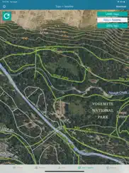
- Satellite + Topo Maps
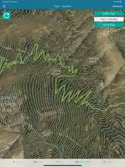
- Hiking Tracker
* Download all maps for offline use
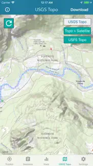
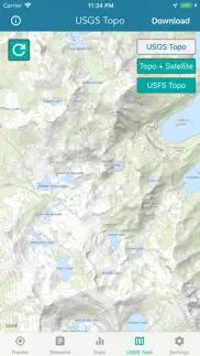
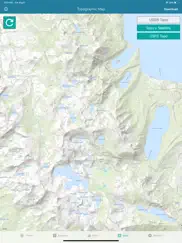
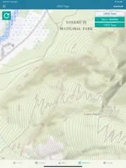
USGS TOPO MAP
USGS Topo is a tile cache base map service that combines the most current data in The National Map (TNM), and other public-domain data, into a multi-scale topographic reference map.
TOPO + SATELLITE
USGS Imagery Topo is a tile cache base map of orthoimagery in The National Map and US Topo vector data. Orthoimagery data are typically high resolution images that combine the visual attributes of an aerial photograph with the spatial accuracy and reliability of a planimetric map.
Data themes included are Boundaries, Geographic Names, Transportation, Contours, Hydrography, Land Cover, Shaded Relief, Trails, etc.
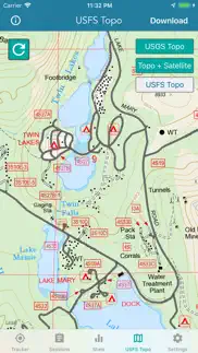
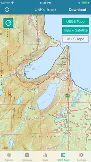
USFS TOPO MAP
The USFS Topo Map Area of Interest covers the USFS National Forests and Grasslands.
HIKING TRACKER
Now you can track all of your hiking stats!
- Track total distance, vertical, time
- Track calories burned
- Keep track of yearly stats
- Color coded tracks by elevation
- Backup your hike data to iCloud
- iOS 14 home screen widget
Have questions?
Feel free to contact me at support@lwbrandsllc.com
😍 Do you love Topographic Maps & Trails app? Please share your friends!

Please wait! Topographic Maps & Trails app comments loading...
Topographic Maps & Trails 1.4 Tips, Tricks, Cheats and Rules
What do you think of the Topographic Maps & Trails app? Can you share your complaints, experiences, or thoughts about the application with LW Brands, LLC and other users?
Topographic Maps & Trails 1.4 Apps Screenshots & Images
Topographic Maps & Trails iphone, ipad, apple watch and apple tv screenshot images, pictures.
| Language | English |
| Price | $4.99 |
| Adult Rating | 12+ years and older |
| Current Version | 1.4 |
| Play Store | topographic.lwbrands |
| Compatibility | iOS 15.0 or later |
Topographic Maps & Trails (Versiyon 1.4) Install & Download
The application Topographic Maps & Trails was published in the category Navigation on 02 November 2018, Friday and was developed by LW Brands, LLC [Developer ID: 963599018]. This program file size is 23.6 MB. This app has been rated by 2,637 users and has a rating of 4.5 out of 5. Topographic Maps & Trails - Navigation app posted on 01 February 2024, Thursday current version is 1.4 and works well on iOS 15.0 and higher versions. Google Play ID: topographic.lwbrands. Languages supported by the app:
EN FR PT Download & Install Now!| App Name | Score | Comments | Price |
| Virginia Traffic Cameras Reviews | 4.7 | 59 | Free |
| North Carolina Traffic Cameras Reviews | 4.5 | 20 | Free |
| New Years Resolutions Tracker Reviews | 4.7 | 769 | $0.99 |
| Turkey Call App Reviews | 4.2 | 251 | $2.99 |
| High Tide - Charts and Graphs Reviews | 3.7 | 215 | $0.99 |
+ Fixed a few bugs Thank you for the positive feedback!
| App Name | Released |
| EV Connect | 09 June 2017 |
| OnX Backcountry Trail Maps GPS | 09 December 2020 |
| KakaoMap - Korea No.1 Map | 27 February 2009 |
| Find My Friends Phone - iMapp | 26 July 2014 |
| Google Maps | 12 December 2012 |
Find on this site the customer service details of Topographic Maps & Trails. Besides contact details, the page also offers a brief overview of the digital toy company.
| App Name | Released |
| Ski Tracks | 05 April 2010 |
| Exit Strategy NYC Subway Map | 07 July 2009 |
| Phoenix Zoo - ZooMap | 19 December 2021 |
| MapOut | 19 March 2012 |
| Aprs.fi | 02 December 2015 |
Discover how specific cryptocurrencies work — and get a bit of each crypto to try out for yourself. Coinbase is the easiest place to buy and sell cryptocurrency. Sign up and get started today.
| App Name | Released |
| Gas | 27 August 2022 |
| Hive Social | 18 October 2019 |
| DoorDash - Food Delivery | 10 October 2013 |
| Telegram Messenger | 14 August 2013 |
| WhatsApp Messenger | 03 May 2009 |
Looking for comprehensive training in Google Analytics 4? We've compiled the top paid and free GA4 courses available in 2024.
| App Name | Released |
| AutoSleep Track Sleep on Watch | 19 December 2016 |
| Stardew Valley | 24 October 2018 |
| TV Cast Pro for LG webOS | 23 June 2016 |
| Terraria | 28 August 2013 |
| The Past Within | 02 November 2022 |
Each capsule is packed with pure, high-potency nootropic nutrients. No pointless additives. Just 100% natural brainpower. Third-party tested and validated by the Clean Label Project.
Adsterra is the most preferred ad network for those looking for an alternative to AdSense. Adsterra is the ideal choice for new sites with low daily traffic. In order to advertise on the site in Adsterra, like other ad networks, a certain traffic limit, domain age, etc. is required. There are no strict rules.
The easy, affordable way to create your professional portfolio website, store, blog & client galleries. No coding needed. Try free now.
Topographic Maps & Trails Comments & Reviews 2024
We transfer money over €4 billion every month. We enable individual and business accounts to save 4 million Euros on bank transfer fees. Want to send free money abroad or transfer money abroad for free? Free international money transfer!
Great app!. I used this app for the first time exploring a neighbor’s private property. Lots of mountains and unmarked ATV trails. The Topo app got me to the top with a great view and good detail. My only recommendation is to add a compass feature so the map rotates with the phone. Great app!!
Doesn’t zoom in enough and no offline maps. Tried to download offline maps and even if I tried small areas I couldn’t get it to work. Price is good and developer responds to emails.
Not there yet. No way to see and manage downloaded maps. No
disappointed. does not zoom in far enough, does. or show enough details, does. it have a search feature
Really good!. Love it, does everything simply and no fuss. The ability to save maps for offline use would make it 5 star!
Incorrect mileage. Great looking app, but I used it once to a hike done on a trail and the mileage was very far off. The hike was 14 miles round trip, but this app counted 24 miles. I trusted it to show my location accurately, but would not trust it to know how far I have gone or what is left on a hike.
Poor resolution and contrast. Poor resolution on satellite, poor contrast on topos. No function to locate or mark waypoint. No way to download maps for offline use....like one might need while hiking.
Perfect for any hiker. An unbelievably helpful app. The download function is by far the most valuable function for hikers that tend to stray out of GPS signal. Cheers to the developer
Great App. The ability to save the maps for offline use is super helpful. Hiking in Alaska means no internet even just outside city limits and having good Topography maps accessible is a lifesaver.
Great!. High quality maps and good interface
I enjoy looking at topo. Topo maps are great to see what it is like on the mountain where we live, as well as family and friends across the country.
No distance scale and limited zoom. This is not a product for serious users. I’m moving to Gaia which seems a better fit for me. For me a waste of money. I did get a speedy reply from my email questioning the lack of features however. That is the only reason I give two and not one star.
Excellent value. The app is a great value at the price. Don’t get suckered into paying yearly subscription fees from other “free” maps. No more credits to buy tiles for offline downloads. The app allows for unlimited offline map downloads and geospatially tracks activity very accurately. I emailed the maker and asked for the option to add waypoints and create tracks. Hopefully those get added soon! Thanks!
A little more data would make the very nearly perfect app. Do an overlay with USGS monuments and data sheets.
These are not USGS maps. These maps are hard to read and are not USGS 7.5 minute topographic maps. False advertising.
Very Solid App. The app is very easy to use and works great. I wish the maps tab and the tracker tab were combined so I don’t have to flip back and forth. I also wish there was a button to center the map on the current location. I used it in a hike last weekend and it worked great otherwise. Used very little battery.
Great app, wish I could rename sessions. Overall this is my go-to hiking app to make sure I don’t get lost. Saving the sessions is awesome, however I wish I could rename the sessions as I slowly don’t remember which one was on which date.
Impressed new user. I have not used any other Topo map apps, but I’m amazed that this one works with such ease. I remember having to send a letter to the USGS and wait for them to mail back the large map from which you could choose which smaller Topo maps you wanted. Then you had to mail your choices back along with your payment and then wait for the maps to be mailed back to you.
Works great, worth the money. It’s great to have a history of my walks and hikes. The ability to sync between my iPhone and iPad is a great feature.
Amazing app with even more amazing support. Honestly I wish every app had the level of support behind it that this one does. I wanted to buy it for my hikes in areas with no data service, and liked what this one had to offer. I still had some questions though before purchasing, so I emailed developer. Within a few hours, I had a reply answering my questions. I bought the app and I’m extremely pleased with how it operates. But I’m even more impressed with the support. Since then, I’ve emailed with more questions and get a reply back immediately. Thank you for setting the bar (actually going way beyond) of what should be expected from app developers. I will recommend this app and your other apps to everyone I know.
Zoom. I like the app, just bought it, but it drives me up the f wall when I try to zoom in on a USGS detail and POOF! it’s gone. Please make it pixelate the map layer instead of making it completely disappear.
Great maps. I’ve been using USGS 7.5’ maps for the past two decades both for work and pleasure. This app has integrated the same data into a user friendly mobile database. A similar Topo app requires you to pay for the same detail that is free here as well as on the USGS website. Thank you for the hard work and detail you’ve put into this app. I haven’t had the chance to use this offline yet but I’ll be testing it out soon.
Planning & Navigation. Pros: 1. Download a topo for a hike. 2. Once tracking is started, a satellite view is presented. 3. You can use tracking mode with satellite view to plan. I discovered this while reviewing a recent hike because there was an old logging road on the satellite view that was not on a topo or Google Earth. 4. Mileage is good. Cons: 1. I like the satellite view, but it hides the Topo map & thus the trails during a hike. Haven’t figured out how to surmount that. 2. Unless you are in cell range, elevation gain is always way low. Even if you just took your lowest elevation and subtracted it from highest, Topo Maps would be low by at least 25%. 3. Thus far, I cannot find anyway to drop a waypoint or plan a track — e.g., using Topo as a planning tool. That said, I love using it for planning & hiking new areas.
Useless!. I wanted to see a map of elevation in my local area, but this app is useless! I can see elevation lines but there seems to be no way to actually read the height. It could be that the numbers are extremely tiny, but there is also no way to zoom in because the map disappears when you zoom in too far.
Great service. I wrote a review about a week ago because the new update caused the app to crash and without delay a new update was available and i am back up and running. Thanks for the fast service keep up the great work
Excellent App for Topographic, Elevation and Satellite Informationn. I needed Elevation on lakefront property and this App was excellent. I was able to see all the characteristics of the property(elevations, satellite, and Topographic). I could not find any info on the Webb but this app had it and was FAST. Great job team!
Fantastic Topographic App. It’s much more difficult to get Topo maps. This allows you to get maps and then go for hike and your path will be recorded. The maps and altitude lines are clearly rendered and useful for route finding.
Pretty useless as a map. If you are looking for a topo map to use while hiking, save your money and keep looking. If you try to zoom in to any scale small enough to actually be useful while hiking, you lose all topo details. I couldn’t get any smaller than miles without just getting a green screen with roads and trails. It may be great as a tracker, I don’t know because it is useless for what I want.
From Martrinez California. 1st impression, it is awesome. I am very impressed with the detail and precision in my area. It will be pleasure to use it other areas and see how well it works for me. Thank you to all the people that helped to create this app.
Horrible on Apple Watch. The whole reason I downloaded this app was so I could see the topo map on my Apple Watch to not have to get out my phone at every turn. Shows time, distance and elevation gain. No map. No other stats. Very under developed for Apple Watch. Don’t use if you’re looking for a watch app.
Topi map free. Excellent! Better when downloading available. You have a topo map wherever you are. Simple.
Mileage very inaccurate. Could be a very good hiking app. I Like most of the features of the app, but one major issue. The distance mileage recording is way off. Not even close to accurate. What’s the point is it’s not even close to accurate. Fix that and its easily a 4-5 star app.
Great job. Love being able to go back and forth between USFS and USGS!
Responsive. Emailed the developer. Nearly immediate response. App is good. Wish there was a search feature with plug and search GPS coordinates, however the offline maps and pins make it well worth a primary or secondary topo app
Works Great When Working. Been using the App to track my hikes since 2019. Wanted to achieve 1,000 miles in a year but sadly lost approximately 200 miles when the App stopped tracking after about a mile. I depend upon accurately tracking my hikes to get donations for homeless and disabled veterans. Losing miles means losing donations.
Good maps and downloading but big drawback. Great overall app and maps but doesn’t have a compass feature or orient the map to heading direction. This makes it very hard to navigate in the back country.
Unbelievably good and intelligently done. There are many apps with similar goals and I own some and tried many of them. This is a very good one, simple to use intuitive in controls, etc. What make is stand out head and shoulders above others is the system of prompts and user guidance that pop on the screen, the device memory use and user friendliness. I wish ALL APPS ON MY iPhone were made by this apps author! Wish list: Integration with iPhone health app. If it is already integrated, I did not see it.
Great detail but DL map issue. It would be 5 stars, but downloading the map is not working for me. Offline With GPS is awesome! That’s half my hunts. I just need the maps to fully download and be zoomable and such.
Topo. Great app for anyone who enjoys or needs to know something about the topography of a site or a route.
Best Budget USFS maps!. I haven’t saved offline yet though I read what to do and I really like this one!
Maps in my pocket!. Love maps in general and I’ve always dug topo maps to visualize my present location in relation to physical features when I’m out and about. Topo gives me everything I’ve wanted to have in a convenient, versatile, great looking app. I’ll keep my paper maps for kitchen table planning/dreaming and as backups, but Topo is my new traveling companion 8-). Get it.
Fantastic App!. I needed a way to find hiking trails around my area. This app gives a lot of information for free! Thanks!
I use Topo for hunting and no complaints. I have not been using Topo for long but I have absolutely no complaints. It tracks accurately and shows me where I’ve been and how to get back to my car.
Absolute waste of 5$. Bought this app for the soul purpose of using the topography feature. Neither map shows any elevation lines, height or anything of that matter. Identical to the standard apple map layout. It does show more rivers and streams than a casual map would. Ive tried this app using my wifi, in different locations, and I've even gone to the extent of downloading a map to see if it changed anything. It doesn't. Very disappointed… do not waste your money. Learn from my experience.
Broken. I’m on an iPhone 5S and this used to work as long as location services was OFF however i recently enabled it and now the app starts to load and switches to background. Every time i launch it it does it again. The app is now wilorthless
I downloaded a map!. What a great feature!
I like this but have a question. I use this app on my daily hikes and walks and I like keeping a visual record of my outings. My question is what the colors represent in the track graphics. I hike some pretty steep hills and while at first I thought the red-green color variation represented incline, it doesn’t seem to correlate, so now I’m thinking it represents horizontal speed. It would be nice to know. Otherwise this is the tracker that I’ve been waiting for. Thanks!
Awesome. I’ve been looking for this map for a while this is just amazing works very well and is accurate so, all I got to say download the map to use offline and just explore. Thank you developer you are just insane 😉
Team Jemazzy. This is a great app! Soo many useful maps and not all the extra junk. Plain and simple to use. We will be using this a lot on our journey. Team Jemazzy 2019
It’s OK. Downloading a offline map couldn’t be any harder, so many other apps where you simply download the map instead of playing the screen recording game this app requires.
Did you know that you can earn 25 USD from our site just by registering? Get $25 for free by joining Payoneer!
Imagine you at your best. All the time. Picture yourself at your sharpest and most productive. Your most alert and focused. Your most lucid, creative and confident. At work. At play. In every area of your life. Add Mind Lab Pro® v4.0 to your daily routine and uncap your true potential. Buy Now!
Adsterra is the most preferred ad network for those looking for an alternative to AdSense. Adsterra is the ideal choice for new sites with low daily traffic. In order to advertise on the site in Adsterra, like other ad networks, a certain traffic limit, domain age, etc. is required. There are no strict rules. Sign up!
Wish I had my money back. I downloaded your Topo Maps app and took it out on a backpacking trip this weekend and I had some trouble. Hopefully you can answer some questions. 1. When I was planning my trip, I was looking at several wilderness areas to download maps for. But, I had a very hard time finding them on the map. It seemed to just show where I was. As I wouldn’t have service in the area I was headed to, that wouldn’t be helpful. How do I search for an area that is not near me without panning and scrolling around? 2. Do you plan on adding a feature to simply download the map for an area at maximum resolution? Hitting “Download” and then panning and zooming is extremely inconvenient for me and it’s very difficult to verify whether I have the map or not. What about downloading the topo and satellite view simultaneously. Why do I have to pan around for both and hope that I captured the area correctly? 3. When I was looking at the map while out in the wilderness, my location icon was always offscreen when I opened the app. I had to pan and zoom around to find it. Where is the button to simply go to my current location? Every map app has that. It seems to like snapping to my current location when I’m sitting on my couch, but unfortunately not when I’m on a trail. 4. How do I know which way I am facing? There is no compass function built in. This is pure insanity. The iPhone has a built-in compass...this is a PAID topographic map app! 5. How do I find my GPS coordinates? I can’t find them anywhere. 6. When jumping to the Tracker for my downloaded map, the map doesn’t load, even though I downloaded it. I also can’t see the view layer I chose in Map. Why? And why is this useless feature the first on in the tab menu? 7. Why does the app tell me my phone ran out of memory and it failed to save my tracked hike? How is that even possible? I’ve NEVER seen a message like that from an app in my 10 years as an iPhone user. 8. Can I please get a refund? Thanks!
Mileage Tracking. Maps well, but the mileage is way off. Not even close.
Not accurate. Maybe ok if you want to know a general idea of a very general area of elevation. Not worth my time though.
GPS signal fail.. Impossible to see topography maps at close range..
Not a good app if your looking for local Hiking trails in PA. Bought this expecting offline biking maps. Nope. You get standard Apple Maps or Topo maps. No marked trails. Wasted my money on this.
Wanted to love it. I really wanted to love it, but the distances seem to be very inaccurate in comparison to my other tracking apps and posted distances on maps.
Which direction. A compass would be very helpful
I hope I didn’t pay for this. Doesn’t seem to work very well
No elevations shown. Map does not show detailed i
Yes!!!. Exactly what I wanted and free 5 stars for sure
I Will Get Back To You. 2 of 2 Don’t worry. I’ve already sent you an email and I got a returned email back with a message that you’ll get back to me. But since then, nothing. I have deleted the app. I really don’t need it anyway. 1 of 2 Waiting. Never mind. Deleted. 9/11/19.
Not Android. This thing requires you to download everything, not waypoints, no route tracking. The Android version right out of download works, if you have cell coverage your map updates. If you are going to a spotty coverage area, you can download map to allow map to run much more smoothly.
Be. Awesome
Wonderful. What an awesome app!
Not correct app. I thought I was getting the USGS earthquake app. Wish there would be some way to cancel this app.
Topo. Excellent app!! Have used it on many trips in woods. The varying maps are awesome.
Mileage is in error. The mileage algorithm reads high. It appears to read high by 58%.
Will not work without cell service, hell you are lucky if it loads with signal. At Yellowstone not one minute did we get to use this, worst 5$ I’ve ever spent
Inaccurate. Tested this on an overnight. Trailhead To campground was 6.9 miles. App said 9.4. Also stopped advancing about a mile before the finish. Elevation gained was accurate.
No helps. Can’t figure out how to use the app. Waste of money.
Bad route. The off-trail route as depicted to Phantom Lake, off of trail 17 west ofEast Rosebud Lake In Montana, is too high on the mountain side and is strongly not recommended. The commonly used and safe route is accurately shown on Rocky Mountain Surveys, Alpine map.
Amazing App. Smooth, fast and detailed, all for free! Thank you!!