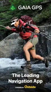
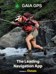
Gaia GPS: Mobile Trail Maps App Reviews
Gaia GPS: Mobile Trail Maps App Description & Overview
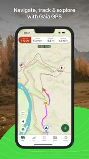
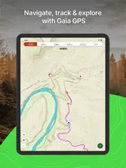
What is gaia gps: mobile trail maps app? Whether you’re out in the snow or exploring scenic hiking trails and amazing offroad routes, Gaia GPS has you covered. Spend less time looking at your phone and more time taking in the snowy landscapes with the newly redesigned app. Backpack, overland, discover campgrounds and skiing routes, or explore breathtaking hike trails thanks to Gaia GPS.
Make the wilderness your backyard with Gaia GPS. Enjoy the best hiking app, road trip planner, and backcountry navigator – all in one. Reach your next summit out on the snow with offline maps, GPS coordinates, and distance tracker features to help you explore the world around you.
Cruise through popular ski tracks or hike trails confidently with GPS navigation tools to guide you through national parks and nature routes. Download the premier outdoor activity app featured in publications like the New York Times, Washington Post, and GearJunkie.
BACKPACK OR HIKE
• Hike trails and running routes are available on Gaia Topo, the ultimate backcountry navigator.
• National parks or backcountry trails – Pave your path out on the snow with nature routes waiting to be explored
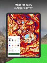
• Access the full NatGeo map collection
• Backpack along offroad hiking trails & back to base camp with breadcrumbs
• Distance tracker with altitude and elevation monitoring for each activity
BE READY FOR SNOW SEASON
• The Gaia Winter base map is designed for winter activities and works well with other winter layers
• Know current conditions with ski resort information and Nordic trails from OnTheSnow
• Skiing, snowboarding, and more – chase the snow with curated snow mobile trails
• Find the perfect snow with Snow Station and Snow Forecast map layers
• Ski reports help tackle any adventure safely with Slope Angle and Avalanche Forecast layers
ROAD TRIP PLANNER MADE FOR YOU
• Offroad travel is easy with GPS coordinates
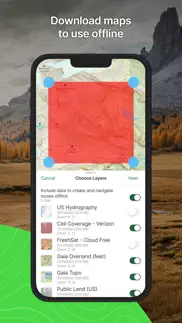
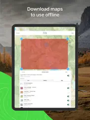
• Offline maps: RV travel is easy with offline maps that track your location, even when far from cell service
• Road trippers can prepare with available parks, route conditions, and activity tracker features
OFFROAD ACTIVITY PLANNING
• 4x4 & overlanding adventures are easy to record on Gaia GPS
• Activity tracker and route planner make navigating trails offroad simple
• Follow ski tracks or create your own routes on the fly with snap-to-trail route building
• Maps, routes, and waypoints displayed directly on Apple CarPlay
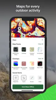
EXPLORE THE WORLD LIKE A PROFESSIONAL
• GPS coordinates help explore the wilderness while creating routes and tracking progress
• Mark ski tracks, hike trails, routes, & campgrounds
• Share your data with clients & fellow guides to improve Gaia GPS
ELEVATE YOUR OUTDOOR ADVENTURES WITH GAIA GPS PREMIUM WITH OUTSIDE+
• Access 300+ maps including NatGeo Trails Illustrated, Private Lands, weather forecasts, and more
• Offline maps to download anytime.
• Weather, terrain, and safety features
• Access the Trailforks GPS biking app
• Expert-led online courses on Outside Learn
• Premium access to award-winning films, shows, and live TV on Outside Watch
• Unlimited digital access to Outside Network's 15 iconic brands including Outside, Backpacker and National Park Trips.
Explore the world with Gaia GPS to guide all of your wintry adventures. Enjoy GPS navigation, skiing features, and countless hike trails with Gaia GPS – your perfect outdoor companion.
SIGNUP
• Gaia GPS is part of the Outside Network. Create an Outside account to access the app.
TO MANAGE YOUR SUBSCRIPTION:
• TURN OFF auto-renewal: https://support.apple.com/kb/ht4098
• Subscriptions automatically renew unless auto-renew is turned off at least 24 hours before the end of the current period. You will be charged for renewal within 24 hours of the end of the current period.
• Your Apple App Store Account will be charged at confirmation of purchase.
• Privacy Policy: https://www.gaiagps.com/company/privacy
• Terms of use: https://www.gaiagps.com/company/terms_of_use
😍 Do you love Gaia GPS: Mobile Trail Maps app? Please share your friends!

Please wait! Gaia GPS: Mobile Trail Maps app comments loading...
Gaia GPS: Mobile Trail Maps 2024.3 Tips, Tricks, Cheats and Rules
What do you think of the Gaia GPS: Mobile Trail Maps app? Can you share your complaints, experiences, or thoughts about the application with TrailBehind and other users?
Gaia GPS: Mobile Trail Maps 2024.3 Apps Screenshots & Images
Gaia GPS: Mobile Trail Maps iphone, ipad, apple watch and apple tv screenshot images, pictures.
| Language | English |
| Price | Free |
| Adult Rating | 4+ years and older |
| Current Version | 2024.3 |
| Play Store | com.trailbehind.GaiaGPS.ng |
| Compatibility | iOS 14.0 or later |
Gaia GPS: Mobile Trail Maps (Versiyon 2024.3) Install & Download
The application Gaia GPS: Mobile Trail Maps was published in the category Navigation on 22 May 2017, Monday and was developed by TrailBehind [Developer ID: 315985618]. This program file size is 138.38 MB. This app has been rated by 29,902 users and has a rating of 4.8 out of 5. Gaia GPS: Mobile Trail Maps - Navigation app posted on 08 March 2024, Friday current version is 2024.3 and works well on iOS 14.0 and higher versions. Google Play ID: com.trailbehind.GaiaGPS.ng. Languages supported by the app:
AR CS NL EN FR DE IT JA KO PL PT RU ZH ES SV ZH TR Download & Install Now!| App Name | Score | Comments | Price |
- Fixed a bug that caused new folders shared with you to not show in the Saved menu - Fixed a bug that made it difficult to add route points along an existing route. This will make it easier to create out-and-back routes.
| App Name | Released |
| Blink Charging Mobile App | 08 October 2022 |
| Premium Parking | 22 October 2013 |
| EV Connect | 09 June 2017 |
| Speedometer Simple | 18 November 2014 |
| Scout GPS Link | 05 August 2015 |
Find on this site the customer service details of Gaia GPS: Mobile Trail Maps. Besides contact details, the page also offers a brief overview of the digital toy company.
| App Name | Released |
| Theodolite | 30 November 2009 |
| NZ Topo50 North Island | 19 February 2013 |
| Trail Treker | 22 December 2016 |
| FSWidgets iGMap | 06 July 2010 |
| FlightReady E6B | 10 October 2015 |
Discover how specific cryptocurrencies work — and get a bit of each crypto to try out for yourself. Coinbase is the easiest place to buy and sell cryptocurrency. Sign up and get started today.
| App Name | Released |
| Gmail - Email by Google | 02 November 2011 |
| 06 October 2010 | |
| 05 February 2019 | |
| 07 April 2016 | |
| WhatsApp Messenger | 03 May 2009 |
Looking for comprehensive training in Google Analytics 4? We've compiled the top paid and free GA4 courses available in 2024.
| App Name | Released |
| Incredibox | 27 March 2016 |
| Geometry Dash | 13 August 2013 |
| Stardew Valley | 24 October 2018 |
| Terraria | 28 August 2013 |
| AnkiMobile Flashcards | 26 May 2010 |
Each capsule is packed with pure, high-potency nootropic nutrients. No pointless additives. Just 100% natural brainpower. Third-party tested and validated by the Clean Label Project.
Adsterra is the most preferred ad network for those looking for an alternative to AdSense. Adsterra is the ideal choice for new sites with low daily traffic. In order to advertise on the site in Adsterra, like other ad networks, a certain traffic limit, domain age, etc. is required. There are no strict rules.
The easy, affordable way to create your professional portfolio website, store, blog & client galleries. No coding needed. Try free now.
Gaia GPS: Mobile Trail Maps Comments & Reviews 2024
We transfer money over €4 billion every month. We enable individual and business accounts to save 4 million Euros on bank transfer fees. Want to send free money abroad or transfer money abroad for free? Free international money transfer!
I put this app through the ringer. GaiaGPS is by far the best GPS app for iOS to date. I have tried countless other GPS apps including those from the “big” companies, and Gaia blows them all away. The map overlaying ability with opacity settings makes creating my bikepacking and bikerafting planning so much easier than before. I was able to identify NFS roads using Gaia that were hard to find on paper maps. Plus Gaia frequently updates the quality and quantity of maps so I always have the most up to date maps on my wrist or in my hand. Honestly, the watch app has room for improvement. It could be faster and have increased functionality (not as much as the phone, but more than just tracking and map viewing). It’s still not that bad though. Worth every penny for the annual subscription.
Nice but dated UI. Firstly this app is useful and it’s convenient for what I need but seems so far behind alternatives like OnX when it comes to a clean and intuitive user interface. Almost like comparing DOS to modern day Windows. If I didn’t already pay for this one I’d switch, but since I have it, I’d like to help make it better. There needs to be better graphics in general and more customization options for waypoints when you click on them. It also really bugs me that you can’t just select waypoints already on the map… you have to click near it and it drops a giant new waypoint, and then it brings up nearby points and you can select your pre-saved waypoint below... good lord that’s unnecessarily complicated. PLEASE, get rid of the waypoint with one click.. it’s such a bad design. At least make it a selectable option in settings? I get the intent but it doesn’t need to be THAT easy to add a waypoint. Adding a waypoint SHOULD be a long press on the map, or just by using the (+) button - not just a simple click on the map, that way people can just tap on pre-existing waypoints/pins/trails and bring up their information without having to constantly clear out a newly placed pin every... single.. time I click on the map. This seems like such a simple fix and would make the app about 1000x better and less annoying. Thanks
The best map application I’ve found. This is my first “detailed” online review ever, for any product. The closest I’ve come is giving something a few stars, but never in detail. I’ve always been the end user of reviews, but this app is well worth the time to share. I’m a bit of a map fanboy. I’ve always loved them and currently have 7 map apps installed on my phone. I often wonder why, when I always end up using Gaia GPS. The interface takes a little bit of time to get used to, but the power of the tool is well worth it. I’m continuously finding new features of the app and I love all the different options. I haven’t found any other application that can do something Gaia can’t. I can’t recommend it enough, you will not be disappointed!
Legit App, I use for hunting and Hiking. I love the GAIA GPS app.I heard about it one time when I was hunting in Idaho. A guy told me about it and told me how you could download maps. There’s absolutely no service where we were hunting in Idaho but he had download it all the maps and was able to charge his phone using a solar charger. Pretty cool that’s where I first heard about it and I’ve been using it ever cents it was about 2015 when I first started using it. I will say it has its bugs here and there but it’s, really long way. I haveSaved Way points for my favorite hunting spots and it’s pretty awesome every year I go back and there are still ready to go. I even got my dad to start using itAnd we hunt in the same area. It was very easy to share all of my weight points with him and so he had all of our history. A lot of times I will take pictures of landmarks and it saves it as a waypoint. I pay for the premium features so I get the hunting maps and all the other good maps that come with it. I have used onyx and other apps and I prefer the GAIA app.
Great tool for mapping motorcycle trips that use lots of off-road.. I’ve been using GAIA to map my rides for a couple of years now. I use it to note where I’ve been, and to mark places I’d like to go, rather than mapping out routes beforehand. I like the detail available in the layers of maps available, (just purchased membership so as to be able to download and utilize Canada backroads layer) the ability to run the app while phone is in airplane mode, and the relatively low power use in that mode. I’ve ridden across the country west to east and back again, and from south to north, and largely off-road. And have records of each day’s ride. I use it to map mountain bike rides and bicycle commutes, and keep multiple parent-folders current with each ride. I also like being able to share a link to my rides with family and friends. I know there are features I don’t use, but feel confident that their use would be pretty intuitive given the ease of use I experience with the features I do use.
2022v7 crashes. Ive been an avid user since about 2015; and a Pro subscriber. Over the past few years, functionality is being slowly lost. Features being removed, or just far more clunky design and slow response. The slow responsiveness sounded like it was fixed by the 2022v7 info, so I updated. Now, IT CRASHES EVERY SINGLE TIME WITHIN 20 SECONDS. No matter what screen its on. I could barely send a bug report and it took me fifth attempt! Still no word back and Im a paying user who uses this for SAR. Our team has been playing with CalTopo lately, and so at least I have that, but a lot of my data is in Gaia. DO NOT UPDATE TO 2022v7!!!! UPDATE: Still no word from support, but being literally useless I deleted it. Did a complete fresh install and reloaded my data from my gpx files. Was a huge PITA but seems to work…so far. Still has a lot of functionality loss I prefer classic Gaia when it was about good maps and mapping features not this new social media type ap. Stop copying AllTrails and give us the old school FUNCTIONALITY.
The Off-road GPS App I’ve been looking for!. I have been using other utilities with roadmaps to plan bike routes on trails and always become frustrated with the inability to make the trace through the trail. GAIA GPS does this and much better, and on the phone. I think its the best App out there for any off-road biking, hiking, backpacking trip planning, easy to use and need nothing more than a GPS enabled phone. I purchased the Premium license when I saw how easy and practical it was to use. My son went on a weekend camping trip in the Appalachian Trail here in Maryland, and things went south with the wind and driving rain. He had to stop and called me to rescue on a Sunday morning, all he did was to mark a trial connecting the nearest road and send me the coordinates. I plugged them into my NAV in my car and it took me exactly were he exit the woods. I’m definitely sold. I’ve made an entire library with future trips in the GAIA GPS Website, it’s all integrated. I plan to continue using this tool for all my outdoor trips.
Downloaded maps stopped working. I have some maps downloaded for offline use and random sections of them stop loading when I try to zoom in close enough to actually use it. It tends to be the areas I use most frequently that stop working at random. If I’m connected to WiFi they do seem to eventually load for me, but not over a strong cell signal or when I have no cell service. They’re downloaded, so there shouldn’t be any issues with loading, even with no service. For $40 a year for a product that I should be able to rely on when I’m deep in the backcountry and my life potentially depends on it, this really is an unacceptable issue. Yes I do have backup maps, but I haven’t even been able to use Gaia to even plan hikes at home because I don’t have WiFi there, and it would be my preferred platform to plan hikes on if it worked at all because I have the trails illustrated map on there. I’d recommend just downloading maps on the free version of avenza because it’s actually reliable
Very powerful tool for exploring the outdoors. I have been using Gaia for about three years now and could not be happier. I have used it with great success for recording hikes, runs, skis, and climbs. It is a great navigation tool. I have found it vital for reaching obscure trailheads, retracing our steps down Mt. Rainier and Nevado Tocllaraju in total whiteouts, and choosing the safest routes for winter travel. There are hundreds of downloadable layers such as slope angle, snow depth, snow/rain/smoke forecasts, recent satellite, and many, many others. You can map out routes and set waypoints, set areas, overlay .gpx files. The applications are endless. The subscription also comes with an account for Outside+, which has numerous interesting films about climbing, skiing, and other sports. Gaia is the best of the best. Any reviews with less than five stars are simply wrong.
I’d call it 4.5. I really enjoy using this app I like to be able to go alone and I have been able to go farther past my skill level just by being confident I could always get back. Looking at doing the enchantments this year solo and I am so excited to not have to depend so much on others. I’ve also been able to find “the end” of my prior hikes and connect the dots in a way that would have required way too many maps and Gaia can always let me see how to put it all together. I have hiked regions for years with a desire to mentally map in a way that this gives me freedom to get back on trail. I wish when the battery died there was a way to continue the trip from where the device powered down. I love the create route but wish it would default in hiking mode without WiFi but over all my complaints are minor details for how much I’ve enjoyed being able to ID mountains correctly in the view and connect the dots instead of rely on speculation. Very much an upgrade to my ability to go farther and feel smart abt it.
Excellent app except. Gaia gps is my go to tool when it comes to finding or creating biking,running, or hiking routes. I gave it 5 stars because of how convenient the many different map layers are.I am a huge trail and nature guy and I was tired of using standard maps that missed so much trails. Well Gaia gps took care of that problem, in fact Gaia gps has not missed one trail in my area and has helped me discover ones I never new existed. It’s also helped me successfully navigate my routes and unfamiliar territory easily and without getting lost. I am thankful for the very existence of this app. With all that said there is one problem. When I use the create route function the map becomes laggy and difficult to use. this is the one thing keeping this app from being totally flawless. So please on the next update patch this issue.
Sounds Like Updates are in the Works. I appreciate having received a developer response that some of the shortcomings outlined below are being addressed. I’d still go with Gaia over the others, and I’d still say there are some needed QOL additions. Some things I believe need work: Poor organization of trips - why have folders and then display every prospective route in the “folders” view? Why no bulk add of multiple routes and waypoints to one folder? There’s no way to see your waypoints on an elevation, such that your waypoints for overnight camps appear in the elevation view. This matters because you can’t get accurate mileage from one camp to the next when planning routes. The only way I can find to do that is to make separate routes for each day, which is fine, until you go to look at the “folder view” and find it filled with 30 or 40 separate routes from various prospective trips. There doesn’t appear to be an “out and back” option to create a full “out and back mileage” and elevation profile - the best you can do is create another point somewhere near the origin. But you can’t put the final point directly on the origin, because doing so grabs and moves the origin point. Multiplying is easy enough, but other apps have this feature, and it’s a nice add. I have used other apps, and each has its own shortcomings. All this said, Gaia is easier to use than others, and it gets the job done.
Downgrading features, making app more stupid.. All the way back to Offline Topo when you downloaded maps you could set the zoom level to download with reasonable granularity. Eventually that app got absorbed by Gaia which at least kept reasonable download options until recently. Now with a recent update you are given just “Low, Medium and High” choices which are extremely suboptimal for USGS Topo resulting in either unreadable details or way larger a download than necessary. Gaia has continued to go downhill over time with basic features being removed or downgraded while useless poorly implemented new garbage gets added. This is the problem with a “subscription” - you pay them to continuously make the app worse instead of leaving well enough alone. Ignore all previous reviews and reputation for Gaia - it gets worse over time, not better. Check out the better options available these days maintained by development teams that improve their apps rather than dumb them down.
Ok, but missing important and very basic tools. I’ve been using Gaia for a while now. Some for hiking, some for overlanding and dual sport, and some for Backcountry Enduro biking. For the most part the app is ok. It’s simple to save maps and record tracks and easy to download GPX files from 3rd parties. But it’s missing some of the most critical and simple functions. At first I simply couldn’t believe what it was missing, but after watching Gaia tutorials and spending time on blogs, I’ve learned it truly doesn’t have them. For example, when route planning you can’t see the distance between waypoints! Unbelievable. On our motorbikes we have limited fuel, so I need to be able to plan for that. I literally have to use a physical grade-school ruler on my screen to estimate distance between waypoints to plan for fuel stops. It’s also very difficult to adjust a route later. Anyway, the app could be great but falls miserably short for route planning. Currently planning an Idaho BDR trip and Gaia simply won’t work. Currently looking for a better solution.
Go To App For Long Distance Hiking. Updated review 2021- The app gets regular updates and they just keep adding content. Cannot argue with that. Love the ability to create a route with lines that snap to the actual trail. Still lovin’ this app after years of use and nearly 10K trail miles. If you backpack more than a couple of night a year, this app is worth a serious look. For me it is priceless. Updated review 2019- Still the Swiss Army Knife of Map Apps. Totally worth the yearly subscription fee. So many options for great maps. Unlike most of the junk on my phone, this app is actually useful. Using it again for the last 1,600 miles of the CDT this year. 5 stars! 2018-I’ve hiked the PCT, AZT, CT, and now on the CDT and have used Gaia GPS for all of them. Would not leave home without it. Must have app for trekking.
The Perfect Multi-Tool!. Gaia is THE mapping application for so many sorts of outdoor uses. Whether you’re trying to map a route in a remote area for running, cycling, or driving, this is IT! The built-in layers are great, and though they’re not all applicable worldwide, Gaia’s own base map (built on top of OpenStreet but with contour lines) is really excellent. The built in route mapping feature is (almost) flawless, and will, 9/10, auto-route to existing roads (improved and unimproved alike), making it very quick to build out routes for austere places where improved infrastructure is lacking. The ability to 1) take it offline and 2) project over Apple CarPlay are also exceptional; seriously, if you have the need to map/plan trips in far-flung places, Gaia’s the mapping application to have.
Filled with regret. I can’t tell you how sad I am that this app, which I placed so much hope in, failed to live up to simple expectations. The problem? After starting the recording where data of my hikes or trips would be retained for analysis later, I found repeatedly that the app would either pause automatically (no input from me) or completely crash. Of course, this discovery would be made only at the end of the hike or trip, so all data I had hoped to retrieve was not there. There is no indicator in the app double checking whether or not I did indeed intend to pause or stop the app; rather, it paused and was silent about it and I was unaware this was happening (or I would have taken corrective action). On the fourth instance of the Gaia app pausing in and of itself which of course included the loss of data I had anticipated collecting, I decided it was not dependable or trustworthy. I had already paid for a full year of use for the app, but I will not, sad to say because I had such great hope for this app, renew.
Delete app to clear cache?. This app has great potential but some real limitations that make me question renewing my membership. Others have mentioned all the great things about the app, so I won’t repeat. What bugs me is that apparently the only way to clear the cache at this point is to uninstall the app and reinstall it. My cache was over 2 gb, so if you’re not keeping an eye on it, it can take over your storage. Pushing the button that says clear cache does nothing. Another frustration, as others have noted, is not being able to see elevation profile once you’re on a route. Yes, if you know how to read topo, which you should if you’re hiking, you can tell when a steep part is coming up, but it just helps to be able to see it in graph format once you’re on the hike. You should be able to see real time where you’re at on the profile — helps to know what’s up ahead (or what you’ve already done…) Final thing is being able to get an alert when you’re approaching a waypoint. Seems like it should be a pretty simple thing to implement, and has also been brought up in the past. If membership was cheaper (or just a one time fee for app) these things wouldn’t bother me. But to pay a recurring fee and see some of these previously asked for features sit in a queue doesn’t seem right.
Unresponsive Technical Support. I’m quite pleased with the iPhone version of this App. However, I like to search for and set up hikes on the iPad version, and this version has bugs. I’ve submitted tech support requests to deal with one or more of these, and am met with absolute silence. Especially since I’ve paid for the Premium version, I certainly expect better. The biggest technical issue I have is that I can search for, and find hikes for which summary info is displayed in the (left) sidebar, including a Preview Map. When I touch the sidebar map, a pop up appears asking me whether to display on the Main Map, Expand the Preview or Cancel. The Preview will expand if that is chosen. However, when choosing Display on Main Map, the area of the trail/hike is displayed by NOT the route of the hike. This fault makes the iPad version of Gaia GPS almost useless for any detailed planning. I’ve repeatedly asked for help with this from Tech Support and get absolutely no response. Conclusion - Don’t bother with the iPad version of this App! … Since posting this review and two weeks after posting my tech support request, I finally had a response. It did not resolve my issue, but at least it was a response, however, late.
My go-to trip planning app. I use GAIA nearly every day planning trips by designating planned routes and waypoints. I photograph wildlife and landscapes so setting waypoints before and during trips is essential: an osprey nest here; eagle nest there; good location for a sunrise or sunset shot; good location for astrophotography; or a snowshoeing route. And I always start a track when I head out hiking or snowshoeing. (I have waypoints set for most of the best-rated waterfalls in WA, OR and ID.) When the thick fog rolls in on a high mountain trail I could easily get turned around and lost. But by starting a track I always have a way back. I carry an extra power pack for my iPhone in case it gets low in power. I also use the camera function to take pictures of trail obstacle to report to the WA DNR and WTA.
Good GPS. Gaia GPS has worked mostly well for me and I plan on using it more. Used it on a 3 day hike recently. The maps are good. It’s accurate. Trails and map overlays are great. It uses very little battery when running offline maps and phone in airplane mode, which I do when there is no cell service. My only complaint is that I’ve had the app lock a few times on my iPhone. Had to close it out and restart the app to get it working again. In addition to hiking, I used it for road navigation in areas where there was little or no cell service. It worked flawlessly in that respect and I really appreciated all the details on the maps. I have downloaded the private and public property overlays, which are very useful when hiking or hunting in Southern Illinois where boundaries are not always clearly marked.
Best I've found by a wide margin!. Gaia's accuracy even when I have zero service is pretty dang impressive. It's often spot on perfect but even when it isn't, it's not far off. At the very least it's always close enough for me to find my way. It also seems to have a bigger database of trails than any of the other apps I've used. Reviews of trails written by other users have always been helpful and led to some great gems and tips on what to expect for a given trail. The feature I personally love the most is the trail tracing feature. You can create two or more waypoints and Gaia will generate a trail path to get you to your destination. It's particularly dumb proof for those of us who are map challenged, and I loooove that it includes a distance estimate. It helps plan my endurance, meals/snacks, time allotment, and expectations. If you want, you can break a single hike into several waypoints so you can know about how long each leg of the trip is. This can help line up your map trail so you can know when to expect obstacles, challenges, route changes, or noteworthy milestones listed in user reviews. For example: "4 and a half miles in there's a really dicey scramble up steep shale. Take your time and be careful!" I *never* write reviews, so it's saying something that I'm impressed enough to write one at all. 11/10 would recommend.
Formerly great app. This app was THE BEST for many many years. I was a huge advocate. But… they recently had some sort of snafu with the iPhone app and lost much of my saved data including many of my saved photos. They no longer have good tech support like they used to when they were smaller, and so it has taken well over a month of piecing things back together to finally figure out just exactly how much data they lost. DO NOT think that your data is safe here with this service. Back up everything somewhere else including photos, maps, tracks, and routes if you think you may want to refer back to them later. The app works fine in the moment, but don’t bother saving anything or you might be sad like me later. ☹️ All good things must come to an end. Update 2 months later - They had another problem and the app lost all my downloads… again! This time it took them over 3 weeks to get back to me. Since the buyout by Outside this app has really gone in the toilet. Super bummed. I used to love this app and company.
Unreliable. I’ve been using this app for 2 years and have never had an issue. In the past month, this app has failed me twice. The first time I was on a 20 mile train run in Olympic National Park and my map was showing up completely blank aside from the location arrow. Never happened before. I had downloaded the map area prior to this so I could see it offline, the app just wasn’t working. This was poor timing as I lost the trail due to snow conditions. Fortunately, I crossed paths with some backpackers and found my way. This happened again yesterday in the Central Cascades and I had to turn back one mile into my journey. Today, a notification popped up when I opened the app saying that the app was not responsible for any failures and “services are provided at your sole risk”. I really have no idea what the point of having GPS is if you can’t rely on it. Obviously, it is smart to have a back up plan for any kind of technology failure. However, I simply can’t use this app anymore, I have no idea if it will work or not.
Awesome! Needs some features though!. PROS: I have been using the app to find trails to ride my dirt bike on. The app does a great job in that it distinctly marks different types of trails and has shown me trails I would have never know otherwise and has taken me way off the beaten path! CONS: One feature that I believe is completely necessary is a Map Filter. For example, if I want to view only Double Track Roads / Unmaintained Roads, I should be able to filter my map to only show those roads. It would make finding new roads a lot easier , since currently you have to visually sort through lots of different roads/trails. Another problem is that a lot of landmarks and trails only show up at a certain zoom level .For example, I have been using the app to show me less popular waterfalls. Once again a map filter for waterfalls would be fantastic. In addition, most of the smaller waterfalls only show up on the map if your map is set at a zoom of 2000ft or more. This means you will have to painstakingly search by panning through the app at 2000ft which is way too zoomed in. If I could see all waterfalls that exist at a 2 miles scale or larger , that would be great ! These downfalls are what’s keeping me from paying for the subscription since it does not appear that the subscription gives you access to these features ! Hopefully this review can inspire an update! I’d love to hear from a developer ! Rick C.
Excellent phone app!. I’ve enjoyed having Gaia on my iPhone and have used it often, and it’s the most functional GPS app I’ve come across (though I’ve not yet tried Onyx and similar hunting and fishing apps that my friends swear by). I was recently in Tanzania in east Africa, and thus my phone was necessarily in airplane mode. However, using the app upgrade I was able to acces satellites and thus constantly see via my location as well as (and importantly) land features that informed about particular landscapes while we were sightseeing. I strongly vouch for Gaia and will continue to use it on my phone. And I quite like the feature - which I use at home in Michigan - that identifies public land parcels, which is necessary for the kind of work and the personal recreation I do.
Great IF you have a reliable cell connection. Every time I have attempted to use this app while in wilderness without cellular coverage, the app has asked me to log back in and deleted my saved maps. I paid $40 for the subscription, I'll plan everything the day ahead, make sure the app is up to date, make sure I'm signed in, manually download all the maps I need, make sure they're saved locally on the phone, close and restart the app while in airplane mode to make sure I can access them without cell service, and then when I actually get out into the wilderness the second or third time I open the app to look at my map it says I've been logged out, I need to log back in, I need cell service to do that, and all my saved maps are inaccessible. Several times on several different trips now. This app is great for day hiking in places that have continuous cell service. Do not rely on it for anything in the wilderness. It will fail you.
Love it!. I have been a wildland firefighter and a guide for a wilderness therapy program (I used maps a lot in previous jobs!) and now I backpack and adventure in my off time and absolutely love this app! The options for waypoints, taking pictures, routes, topography and off line ability show me where I am on the map is amazing. I even upgraded this summer (when wildfires were seemingly everywhere) to add the layer of hot spot detection. *I did not use this to decide where to hike during the fires, simply just to see where the fires were- very dangerous to be anywhere close to the forest fires as they can shift directions at anytime! Gaia is great because roads and routes change all the time and great to have an updated map (though not always perfect- but the closest I have seen). I have thought about buying a separate hand held GPS, but having this app negates that need. 100% recommend this app- it is free for basic things and you can pay for an upgrade if you want.
Falling behind its competitors. I had been a Gaia subscriber since 2015. At that point it was an industry leader and profound innovator in backcountry map technology with offline capability. I used it for Search and Rescue as well as personal backcountry pursuits. Unfortunately, especially since being acquired by Outside, it feels stagnant and clunky compared to its competitors, like OnX or CalTopo. Whether it’s deficits in ease and accuracy of route planning, poor use of 3-D technology, it’s unreliability integrating various file types from the web, or weak map tech for winter backcountry pursuits, Gaia - who was once an innovation leader - is now being left behind. It now feels as much a social media product (like AllTrails, but not as established) as it is a navigation product. I guess what should you expect? The innovators behind the original app have long been replaced by Outside Magazine appointees whose imperative seems to be generating brand traffic and cash flow rather than improving a product that once was the best in the business.
One of the best mapping software out there. I use this for personal and volunteer search and rescue. There are a couple other alternative options out but I am most familiar with this. I have a paid version but can’t remember what level. Super easy to use. Modifiable home screen for quick access to data (distance, speed, elevation, coordinates, start/stop) depending on which is needed most at any given time. Ability to download and store maps, even over cell and from the app. Can run most functions from the app but can also access through desktop. Store and share .gpx files easily. Can now set up and delineate areas (SAR function). Add photos to routes. Set privacy settings. Most functions very intuitive and easy to use.
Map Packs - A Ton of Potential!. 5/8/22 Update with comments on new Map Pack feature. Still a 5* app. I wanted to provide some feedback about Map Packs. I think there’s a ton of potential here and I’m using it as my daily map layer function. I wanted to comment on a few things: -I think you need to allow a horizontal scrolling of your various Map Packs and Overlays when you summon the Map Packs feature. Right now it feels like too many clicks to get to what you want. -I really like that the Map Pack button is at the bottom. Mostly because its easy to get to on large phones plus the animation comes from the bottom so it makes sense to have the button down at the bottom. -Right now it looks like the Overlays, when you add them, adds them at 50% opacity. It would be great if you could control the opacity in the settings or somewhere -The animation for the Map Packs layer slider window pop up needs to be smoother. Right now the Map Pack window just kind of “appears” when you click the button. Would be sweet to have a smoother animation when you open and close it. The bottom bar kind of jumps back up without much animation either, would also be nice for this to look more fluid Hope this is valuable! I know its in beta and will likely get better with time. Hopefully you guys stick with it though because this is going to be awesome!
Best off road navigation app available. I have been using Gaia for about 4 years. It is the best app available for making routes and marking spots on the trails. You can take photos while on a trail and the pictures will be placed on your maps exactly where you took the pictures. It’s not too difficult to learn. You can easily import or export your tracks/routes to share externally or you can even share your routes within the app. I would and do recommend Gaia. I started with the free version and then the first level upgrade and am now using the premium 5 year subscription version. You can find discount codes on several overland forums. The free free is perfect because it let me try it out before I committed to the full purchase. Try it and I am positive you will love it as much as I do!
Gaia came to save the day !. While taking a new way from Colorado to Utah I went through a dead zone where my navigating app dropped completely with no signal to accurately follow my pre planned route so I resorted to my compass and map and proceeded to follow what it looked to be the appropriate way on the map and have in mind all of these while a Thunderstorm is raging in the background. So after my soon to discover erroneous choice and 27+ miles later of Offroad muddy rainy and lighting strikes all around… I must admit even so I love off-roading being alone in a remote area under these conditions was a bit intimidating. Well short story this route came to a holt because of a lock gate. Realizing my mistake I turned around and had no choice but to drive back through the storm I was hoping to out run so needless to say the area was beautiful but the storm was making it a bit harder to appreciate at the moment. After what it seemed a while of negotiating wet obstacles under lighting and Phone Alerts to seek Higher ground I made it back to the main road this time deciding to make a quick right and seek shelter while I figure out my next move. I drove maybe a couple hundred yards and I remember I had previously downloaded this region map on GAIA so I loaded it and YEAH ! here where the answers I needed, clear marked mapped routes and completely offline. So here it is Gaia thanks for saving the Day !!
Great App with a couple minor issues. Let me start by saying I use a Premium Subscription and absolutely love this app and use it nearly daily for both work and recreation. I does so much that it has become a must for use with my fieldwork. My only complaints are the randomized coloring when importing tracks and the was area shapes are created. Using this app professionally, I often need all of my shapes to be specific colors or all one color. Often I can just quickly adjust them in the app, but when I have projects with hundreds of shapes this is no longer a viable option and is very frustrating. Simply allowing bulk adjustment would solve this problem for me. The second issue regarding creating areas is that often when I try to move the dots that adjust the area, it grabs the screen and tries to move it instead... sensitivity issue maybe? In any case, these issues are not deal breakers... I love this app and will continue to use it, but hope that these two simple things will be addressed in the future. I know I’m not the only one that would like to see this! Thanks for a great app!!!
Garmin killer?. I initially got this app (basic membership) as a backup to my garmin unit while riding the backcountry on my dual my sport dirt bike. I have both gps and phone mounted on the handlebars of my motorcycle and have the Gaia app running to explore trails and track my rides. So far I’m really happy with the way the app works and how accurate the gps is using the offline maps. After using the Gaia gps for a couple weeks it might become my primary gps and the garmin will go in my pack as the backup. Another feature that I like is the ability to create waypoints and routes from the Gaia website and have the routes auto sync to the phone app. This it much easier and faster than the garmin/basecamp setup and makes pre-route planning a breeze. You can also import gpx files from waypoints into the web portal pretty easily.
Importing back country camping zones. I use the Gaia iPhone app almost exclusively to plan my adventures, and I rely on it constantly while hiking to stay oriented and on plan. It gives me the peace of mind to tackle trips I would otherwise not feel comfortable attempting. For planning I use the app literally hours each day: route creating, adjusting, recreating; adding waypoints for important, interesting things to note while hiking; relying on the included interactive trail lines and the various map layers to design accurate, safe trips. It is by far the most important tool in my hiking toolbox. Even though I’ve gotten quite good at using the app, I’m continually finding new and amazing things it can do. For instance, I’m planning a backpacking trip to Denali where backcountry camping is regulated by zones and quotas. The National Park Service has a wonderful paper map that shows these zones. I found that their website allowed me to download a data file of the zones and to my delight I discovered the Gaia app easily imported them along with included metadata. What an amazing planning feature. I have many other examples of how I use the app but will save them for future reviews. Don’t think twice: buy the pro version and use it, use it, use it.
Great app with annoying bugs. No need to expound on all the great features of this app. Some warts this far: 1) Elevations are hit or miss. Routes that you add typically don’t have consistently meaningful elevations—you have to create the route then edit -> “look up elevations”. And even then the elevations aren’t the same between the phone app and browser app. 2) App auto-routes and shows trails in areas that are definitely not open to the public (as in you’d need to climb over a clearly marked “no tresspassing” fence to use that path; this situation has arisen twice in 2 weeks). I ended up pairing this app with Strava’s global heatmap to make sure I wasn’t heading the wrong way. Why can’t Gaia GPS partner with, say, Strava or Garmin to crowd-source viable routes for hiking? Or at least clearly identify private property?
The best. One of the best mobile apps hands down. The app has easily saved me from getting lost several times. It might have even saved my life. The interface may not be the most intuitive but once I got used to it, I was fine. The app has ALWAYS worked without cellular service. I’ve used it in this manner over a dozen times for a total of about 30 days in two countries. The key is to download an area map to your device before you leave cellular coverage and load it when you are ready. It’s also helpful to establish known waypoints before but no biggie if you don’t. Two negative observations some of Colorado’s 14ers are listed at the wrong altitude and if you cache equipment and use this app to waypoint the arrow that shows your location to the waypoint will continuously move location even though you are standing still. It still, in my opinion, a 5 star app!
Best GPS and hiking trail map app. I love this app because it doesn’t drain my precious cell phone battery and works great on airplane mode. We just finished a 4- day climb of Mt Whitney and Gaia performed so well! It oven had a map of the fires on the other side of the sierra ridge that I had downloaded before we left Whitney portal. I was able to photograph many locations along the trail and correlate them easily to their locations on the map. I love this aspect. There are a few improvements like making the photo UConn a little smaller and making the relationship between the map, the compas heading, and the direction of travel more intuitive, but it was probably me doing weird things like angling my phone up in the air etc etc Lovely app thanks!!! Had my topo map but never used it because Gaia was so good. This is the first time I’ve used it for an extended trip away from cell phone reception and I found it to perform better than expected. For over a year I’ve been mainly using it to record day hikes and keep track of my biking and running and hiking workouts.
Great app for off-road trails. I use this app to track the dirt bike and atv trails in my area, but also when I hike to see the time, distance, speed, and elevation changes. Some of these trails are hard to find and get very deep into the woods so I need the app to be accurate and it works very well here in New England, even when I don’t have good service. I love the track system, it’s awesome that you can name it, change the color, and add stops/labels. Seriously this is the best free app I’ve ever used and I recommend it 100% as of the last update. I haven’t used the app since this new update so hopefully nothing has changed too much. I appreciate the devs creating this and allowing people to use it for free- 5 stars for sure!
Confusing payment levels. Gaia is a great map app. I’m paying for a basic membership and see a minor improvement over the free version. But it is an improvement so I’m not complaining. It’s easy to understand there are 3 levels of membership but I found it difficult to understand exactly what features are unlocked with each membership. For example, overlays, the feature I most desired, is no available in the basic membership. If it’s affordable for you, I would advise you to purchase the “premium membership” to remove any limitations. I wish I could clearly display the features for each membership in this review. If the premium membership’s cost is a barrier for you. You should chat with Gaia support before you buy to know which membership is right for you before you spend money.
Essential adventure companion. I use GAIA for everything. From weekend overnighters, to week long off-trail hikes through the Sierras, backcountry touring, and I’m even using it to plan a CDT thru-hike. All the essential information is available on the free version, but the pro upgrade is worth every penny. I use the slope-angle shading to assess how hikeable passes or how avalanche prone certain routes are. I also use the snow-depth layer to monitor areas I want to ski and how much snow to expect on the CDT. There’s also an avalanche forecast layer that’s particularly helpful, weather forecasting, and change in snow-depth monitoring. Current Native American lands are shown, and you can toggle between the famous Nat Geo National Park maps and GAIA’s own topo’s. (I find GAIA’s topo’s to be the most useful). I’ve recommended this app to everyone I know who spends any time in the outdoors, and I’ve required people in groups I’m guiding to at least download the free version so I can share our planned route. My girlfriend considers herself directionally challenged, but on our first trip where she had GAIA on her phone, she immediately became a reliable orienteer. (Or at least a tech-assisted orienteer). This is a fantastic tool and I highly recommend it.
Saved my life!. I currently run the free version off this app but plan to pay for it after it saved mine and two others lives! Other than keeping us on our trail and knowledge of elevation and topo lines it contained our exact coordinates when things got hairy! An unexpected snow storm rolled in on us and lasted a little over 48 hours and full on blocked us in on a trail that was hiking access only. We managed to get cell service at the top of a cliff and send out our gps coordinates from the app and as soon as the storm cleared we were evacuated safe and sound with minor symptoms of hypothermia. Had I not had this app we would have been in a far worse situation just waiting for them to find us as pinging our phones lead them to believe we were two mountain passes over. I never thought a silly map app would be something I relied on so heavily!
Possibly the best app ever. I am an avid outdoorsman, private pilot, recreational fisherman, big game hunter, etc. and I have used a hundred different GPS/mapping/geolocation/topographic maps over the years. Gaia is by far the best all-in-one map app I’ve ever used BY FAR. Used free version for a while and decided to upgrade to paid version and it is money well spent. This app has literally hundreds of overlays from cell service coverage to 24 hour weather forecasts to private landowner information to USGS topo maps to VFR aeronautical maps. I couldn’t recommend this app more highly to anyone who spends any amount of time in the mountains, or boating, or hiking, camping, cycling, kayaking or big game hunting. In my humble opinion this app is indispensable for outdoor enthusiasts of any kind. Probably my favorite feature is the map overlays — you start with a solid base map like Satellite imagery or OpenStreetMaps and from there you can start stacking other maps on top of it with varying transparency. I also like the trip recording feature, which you can trigger from your Apple Watch and it will record distance traveled, elevation changes, average traveling speed, and even show you a cross section of the ascent/descent changes made on your trip. I honestly can’t say enough great things about this app…you’ll just have to download it and see for yourself.
Lol best gps I used - better than dedicated gps devices. Been using this app for several years. I pay for the annual subscription and it’s worth every penny. I use this app for trail running and backpacking mainly. I have and iPhone and when out in spotty cell service areas I turn my phone on airplane mode and this app works great as long as you have the maps downloaded earlier. Having the gps app on the phone gives you the modern touch screen and convince that the other dedicated devices (garmin) are still struggling to replicate. The phone is something I already have and the battery in my iPhone last a long time. I also like being able to use the app on my computer and plot/estimate plan hikes and runs. It will give you distance and elevation which are things I like to know before going out on long runs in areas I never been. I can’t say enough great things about this app, it’s great!
Great to plan routes for off-road riding. Downloaded the app and tested it for off-road motorcycle. The automatic tracing of a route over existing marked trails is an awesome feature that makes planning the route considerably easier than with Google Earth or Garmin Basecamp. I downloaded satellite image and usgs topo maps of the area I was riding in so I didn't need to rely on having network or not during the ride. Battery usage was reasonable and it can certainly last for 12 hours or more with every app turned off and airplane mode. The website is fairly good too. Only small complain is that the web app folder system is a little convoluted - it's not obvious at first where things go at first. The mobile app occasionally crashes while managing files, yet nothing was lost. Compare to a Garmin gps unit the only limitation is the device's gps accuracy and recording rate but it's no issue for off-road riding/driving, likely not an issue for hiking neither.
Hands down the best digital map app ever created. I have been a power user of GPS devices and digital maps since the earliest handheld GPS units long before smartphones. I’ve used them extensively for exploring and hunting throughout the western US, Canada, Alaska, and a little in Africa and Europe. I’ve used most of the popular mapping apps. Until Gaia came along we had to rely on a certain app to obtain land ownership status which is important for hunting and hiking access in the western states. But the other app was weak in so many other ways. Gaia solves these problems and much more. The suite of map layers is unparalleled. Game management units, USFS, roads and trails, satellite, numerous topo maps, private and government lands, parcel ownership data, Nat Geo Trails Illustrated, and much more. It’s all there. And exceptionally easy to download and use. Super stable and simple to use. The tracking function works perfectly. Sharing of waypoints and tracks is simple and reliable. So many thoughtful and useful features. Gaia is simply a brilliant outdoor activity maps and GPS app. Regular updates make it better all the time too. Premium subscription is worth much more than it costs.
Best by far...still. This has been my backcountry navigation app for years in the Rockies. More and more friends of mine are using it now and although we all try other ones, this is still the gold standard for me. The ability to turn it on and see where I am on both the USGS 7.5 min map and a satellite image, with blending of the two images, is awesome! That is a Premium tool... well worth it. I use it for both on trail and off trail navigation and planning to find and get to high country meadow fishing spots. This is also an excellent hunting tool: I plan my deer hunts with it. It is great for figuring out new hunting camp lands... especially because the imagery shows new timber cut areas so well on the topo overlays. (Also, they finally got the detailed NOAA chart of upper Mobile Bay, where I boat, on the premium so now I’m using it more in my boat. Thanks)
Watch Application Ruined. And now. lol. Start a new track and hike several miles. Each time you turn your screen off and come back to the application or switch apps and come back the map re-centers on the starting spot. :-(. They also at these new prices need to have faster download servers. Crazy slow. Still the bat hiking application. But still they had feature in there watch application that made it useful for real backpackers. They added features but still feel the need to remove the ability to spy on a phone based track from the watch. I don’t even install the watch application. How is that battery going to track its own separate track with gps and last for days or weeks? You know one cannot charge the Apple Watch without removing it? But the old app allowed me to run the real track on my phone and just check progress on the watch. It was perfect. Instead they kill that feature raise the price to the point where a year costs as much as five years did a couple years ago. Sigh. I mean really if I want a non-intergrated Apple Watch hiking application then I will just use the one built in from Apple. The old application allowed for a real backpacking experience that I get grated the longer and renewable battery life of the phone with the ability to quickly check progress on the watch. Now if you have a trip longer than a handful of hours then the Watch application is worthless.
Best GPS and map source available and has been for many years... I got this app about 10 years ago and I have loved it the upgrades have continued to improve it very well. I would not go with any other app out there I have tried other ones like x hunt and I did not like it. It is years behind this app. You get the personal property lines and public with this app, lots of layers that you can overlay and download. My entire family and extended family got this app too and they love it as well. Don’t waste your time or money with one of the other apps. This one is the way to go. Best app available. And I use this all the time not just once a year while hunting. I use it for hunting, fishing, camping, hiking, snowmobiling, horse pack trips around the farm... the tracking ability is very accurate and doesn’t drain my battery. I turn off my cellular data and all that and use it to track and it goes all day with out killing my battery and I have a 3 year old I phone. This is the only app that I would recommend especially because I have tried about 20 other ones over the years and this is the one I stick with. The subscription is worth every penny as well. Don’t worry you get your money’s worth with this app. They have an amazing app.
Did you know that you can earn 25 USD from our site just by registering? Get $25 for free by joining Payoneer!
App not staying on screen. iPad user , App will not stay on ,get screen up however will not fully load and stay on just drops off . It works fine on my phone all other apps I hav3 are working fine on IPad. I have deleted from my IPad and reloaded however no good.
Great for hiking. This app has been of a great help for me in different hikes. Easy to use, simple and flexible, allowing you to export and import gpx and klm files easily. Nice design as well.
Others tracks.. With past tracks displaying. You know your path has made it in the past. A level of confidence.
App is good, Apple CarPlay isn’t.. Honestly the app on it’s own is great. But the Apple CarPlay function isn’t there yet. It’s extremely glitchy. I find myself having to close it and reopen it often to keep it working. Definitely needs some work.
Unusable as can’t creat an account. App is unusable. Requires me to create an account then claims my email address is a invalid email when trying to creat the account.
Great app for bushwalkers.. Very versatile and comprehensive. Easy to record walks. Very useful for walking long iconic trails.
Best of the Best. I’ve tried so many apps, over more than a decade of working & playing in the wild. This just gets better & better. It’s the fine wine of Nav apps. Very excited to use the new Map Packs beta. Thanks for the hard work!
Reduced screen size. I've been using Gaia GPS classic for a long time. It has its downsides like all apps but is overall very good. This app on the other hand is really bad. The amount of screen screen left for the map is minimal and finding tracks, folders etc is much worse.
Grate App. Awesome app for exporing and 4WDing able to keep track of everywhere iv been and name all the tracks to keep records of them
Not good enough to be useful. On the surface the app seems good, but selecting and editing saved routes is too unreliable and frustrating. Maybe using a browser it is better, but on iPad it is unusable. Can record routes o fine, but after that it is no good. Because editing is rubbish it means route planning is a problem too. I have AllTrails but that is no good for route planning. Will try Memory-Map next.
Multi purpose tool. I have been using Gaia for years now and it’s great. I use it to take waypoints and tracks. It can import or export files kml and gpx, very handy for making the program show you boundaries or features. The offline map feature is very handy it has got me a short cut out of the bush a few times. I also use the watch feature. The help for Gaia is the best they quickly reply to my questions. Great product could not recommend enough.
Great for off line maps. Great while off line . And also has plenty of camp sites too
Total rubbish. Can’t even find my location and I get other peoples routes glad I did not pay for it.
Awesome. Tried many apps and all have lots of weaknesses but this one is having a real crack and always making improvements and is very easy to use. Love it.
Great offline maps. I use the paid version of Gaia and think it’s amazing. The offline maps are great for when there is no phone signal. I also use it on my computer for route planning and looking for spots to camp. You can also export your routes as GPX files for other people who may use different software.
Best mapping app I’ve found. I do lots of dirtbike riding in local forests, hills, and mountains, and even sometimes some four wheel driving, and I’ve found this app better than I expected from any mapping app for all of this. Especially using the map overlay feature where you can semi transparently overlay one map over another, and see more clarity of tracks, and different contour detail across two maps. Please never stop making this app! It’s one that I don’t want to ever disappear! I love it just how it is 👌👌
No good in Australia. Topo maps are crude. Satellite imagery is outdated and very low res. Disappointing as they claim stuff that simply doesn’t work.
Seriously buggy. I have been using Gaia for over a year and have found there to be constant bugs, I paid for a subscription but will not be renewing as the latest bug crashes Gaia when I try to add a point.
Brilliant app. I have been using the free version for a while now and find the Gaia gps app fantastic. It’s used for tracking local bush-walks and fire trails and has never let us down. Easy to use, record and save trails and gives plenty of data such as location, speed and ascent de-scent.
Fairly good - needs snap to rivers. Fairly good. Probably better for US users than Australian though. Needs snap to rivers so kayaking trips can be planned. The web/app interface is very good.
Offline Maps, horrendous download speed. The maps are great. IF you have reception. If you plan using them offline don’t bother, download speeds are in the kbs. Simply not acceptable in 2021 to have such a slow download when you are charging for a subscription.
Coordinates. Searching for coordinates does not work. Even copying and pasting Gaia’s own coordinates into search don’t work?!?
Turns iPhone into genuine GPS. I have been looking for an App that would turn my iPhone into a GPS device. It is very simple to use, to plan or record a route is simple and the ability to download maps for offline use is a great feature. If you read the advice on conserving battery life it seems quite light on battery usage. Very happy with GAIA GPS and have recommended it to quite a few friends.
Awesome!. I had been using Hema Explorer Pro for a while but the app was buggy - they never updated to the larger screen sizes of the newer devices such as the iPad Pro 10.5”. Changing to a paid Gaia subscription was the best thing I could have done. The app works perfectly, updates are regular and the quality of maps are superb. I get much better detail of Australian Tracks using the “Mapbox Outdoors HD” map layer which also includes topography. Easy to plan a route both on device and web and sync of waypoints between devices just works. Easy to download maps for offline use and the ability to print maps from the web portal. Offline maps worked great on a recent bushfire deployment providing medical cover in support of the RFS. RFS were using grid refs, we were using Lat/Long and the app converted easily between the two formats. Highly recommended!
Great - but please fix CarPlay!. Works fantastically on iPad and iPhone. Best mapping app I’ve used. Great for planning and logging trips. CarPlay though needs some work. Direction of your icon doesn’t display correctly unless the phone is unlocked and on. Layers often don’t show correctly unless fiddled with on the phone until they snap into place. Not ideal when driving.
Great Idea but can’t download the maps.. The whole thing looks good but with high speed broadband I have never been able to download maps the app has to be open to do the download and to download a map can take days.
Hopeless. 26% battery life over an 8hr period when not in use. Recent updates dates stuffed up the effectiveness of this app
Still faulty. The latest version still doesn’t correctly record total ascent. On this morning’s work out it was showing 152m at one stage, then 137m by the time I finished. Very frustrating. MotionX GPS can do it, why not Gaia?
Amazing. This is the best off line/ bad reception app ever, I do a lot of work and play in the southern forests of Tasmania and this app is amazing to know exactly where I am at all times. Great app worth every cent.
Great App. As an active family we find this app very handy to find all different tracks and hikes around our location. This is a must have app for a fresh and fun hike every week, every track is satisfying at minimum and excellent at best. This app sets an unbeatable standard and is great for all round use.
Best mate off-road. Best navigation ever used for off-road. Highly recommend
My GoTo GPS Hiking App. This is the best hiking and GPS app I‘ve found. Not only for tracking our hikes but also exporting my data to GeoTag the photos we take along the way. I use to have multiple apps loaded and constantly switch between them for all my interests. Now I focus only on the best apps and learn how to maximize the benefits they provide. This is my go to hiking app. There is nothing better. I turn this on before I even put my backpack on. I thoroughly recommend it.
Nothing for Western Australia.. I paid for this app and have discovered that there is just blurry unreadable sat maps for West Australia and that’s obviously where I live, I have wasted 55 dollars for an app that I won’t be able to rely on when I go wheeling.
Good functions, mind the bugs. This is a very functional app, with a few funnies. Full disclosure I have premium so your experience might vary. I love the access to offline Australian government topo maps. Detail galore! My upgrade wish is for these to be available to view on Apple Car Play instead of restricting these to the base map so I can use them 4 wheel driving. Please? I’d love for the search function to be upgraded and debugged. I search for well known places across Australia but they sometimes don’t show up. Lesser known (gazetted towns) are nowhere to be found. I click on an alternative nearby then my start location defaults to this random pin every time I open the app. It’s frustrating. Otherwise keep developing it! Awesome app I plan to keep paying to use…
Recent updates have ruined it.. Alright I’ve been using GaiaGPS for years and it has always worked well, until recently. The more recent updates have drastically interfered with the way the app processes offline maps. I had 11GB of offline Australian maps downloaded that needed to be re-downloaded because they weren’t displaying correctly. Even after re-downloading the maps, they display slowly and don’t show much information until you zoom in completely. I don’t know what has changed over the last few months with GaiaGPS, but if it isn’t fixed I won’t be renewing my membership.
Downloading maps frustrating. Great app if you are in 3G or 4g coverage area. Downloading maps for use in areas with no service is an exercise in pure frustration. Downloads either do no complete, do not automatically resume (even with auto resume selected) or go so slowly that one can tear ones hair out. I would say app basically useless if wanting to download maps to plan trips in outback areas.
The best. I’ve been using this app for a couple of years through multiple local hikes as well as Camino Santiago (French Way). In my experience, the best of all.
I love Gaia GPS. I love that I can set a route, meter by meter, on my phone and it appears on my PC or the the other way round. The outdoor maps work great in Australia
Totally screwed. This had been working fine, I had all of my Maps preloaded on my phone, out in the field it automatically updated which deleted all of my pre-downloaded TOPO maps for my journey. I thought that’s fine I’ll just download them again, nope they will not download at all and if they do download they only do a fraction of the file.
Great app but now crashes since 5/2/2023 update. Pls fix why app crashes as soon as I click to open a folder. Nothing changed on my ph, soon as I updated the app it crashes
Destroyed by new update. I do not have access to a range of Australian maps. I can only get Satelite Topo in feet, which is completely useless. I am very unhappy about the changes.
Great phone app but terrible for Apple Watch user. Plenty of info for the iPhone app - and for that it’s great but the fact that you show an Apple Watch on your front page is very misleading. The Apple Watch functionality is useless and it doesn’t work, so only buy if you plan to ignore this ‘feature’.
Very glitchy. The subscription isn’t cheap. Considering that, and that ones safety depends on the app working properly, for the app to be very stable and reliable. But it’s not. It keeps hanging, crashing, missing bits of route-tracking, glitiching in bits one never did, …
Surpassed Hema - excellent. Excellent maps for Australian 4wding. I don’t use any other apps now. I use this on an IPad and the maps are first class. Very nice maps to look at and the app itself has been flawless. If you are sick of the other brands clunky apps get this. Very happy
Awesome navigation tool. This app/software program is a really neat package with a lot of really cool features built in. You can us this app from trip planning and preparation to following a route or logging where you have been. It is easy to drop waypoints and make notes on these to remember what is there. This app is really great bang for your buck. I have used many other software programs and this is really one of my favourites!
Works brilliantly, until it doesn’t!. This is a great app which i’ve been using professionally for a number of years. It’s amazing when it works but it can be slow to open and can crash when used over a prolonged period e.g. more than several hours.
Problems downloading maps continue. Downloading Gaia gps maps is a big problem. Even if appears to work they turn up against next time as not downloaded. This has been a problem for a while but getting much worse. This was my favourite mapping app: together we’ve walked thousands of km but, now, i despair every time I want a new section downloaded to use offline. If it says it’s downloaded will it be? How many times will I have to repeat the apparent download to get a real download. Yes, I’ve read the faqs and tried to find a way to contact developers. I was a very happy user a few years ago. Not now. And searches: may be useful for North America. But try finding even a well known place in the UK. Good luck. You’ll need it. Disappointing.
Amazing free app. Great free features, but elevation profile is not very accessible, and the watch app waypoint integration with iPhone track recording has been removed :(
Imagine you at your best. All the time. Picture yourself at your sharpest and most productive. Your most alert and focused. Your most lucid, creative and confident. At work. At play. In every area of your life. Add Mind Lab Pro® v4.0 to your daily routine and uncap your true potential. Buy Now!
Used to be good - now useless. With Outside’s acquisition of this app it seems to have gone to pieces. Most fundamentally, despite having a subscription I can’t sign in or even change my “forgotten” password. Useless piece of junk.
unique app, great. unreliable ios sync feature
METRIC USERS BEWARE. ALL of the Metric topo maps provided in the free AND premium subscription are corrupted, the contour lines are not accurate, cross bodies of water, and so on.
Outside+ is more of -. The subscription syncing between the apps doesn’t work and it tries to trick you into buying the same subscription when you have it on another device using the same account information.
Can’t even set the app up without getting errors. I installed the app, try to create an account… “invalid email”. Tried using auto fill and manually typing it several times. It’s not invalid but the error insists it is. I’ve never used the app or heard of “Outside” before. Just in case it was acquired by another site I had an account with, I tried to reset the password. “We sent you a link to reset your password”. No, no you didn’t. So my valid email isn’t valid and your password reset function doesn’t work. I suppose that’s all the Gaia trial I needed. Sure as hell wouldn’t be putting any faith it in to plan anything outdoors if it can’t get basic account setup correct.
Excellent app, best in class, used it for years now. I love being able to cache sat maps, edit tracks, etc, etc…it’s never glitched out nor let me down….
Unable to control language settings. I downloaded this app in hopes of navigating trails in Taiwan. The trails were there but everything was in Taiwanese. No issue if you can read Chinese but it would be helpful if there was a setting that allowed for translation to the language of your choice. For this reason I chose another app to use.
Couldn’t get it set up.. Couldn’t get past the ‘ Outside’ loggin set up. It didn’t like my email address and I quadruple checked it to ensure it was typed correctly… wouldn’t take it. Couldn’t opt out of that either, for some reason. Hear it’s a great app. Sorry I can’t give it a go. Might have been a 5* but not for me.
Great GPS app. I use this app on my iPhone. I’m in north western Ontario. It works great for me. I’ve been using this app for quite a few years now. I don’t hike as much as I used to but it works great for off road atv and snowmobile exploring.
Don’t too small. I hike often in the Canadian Rockies and Gaia is my go-to app. However he don’t is very hard to see on a phone now and it does not increase in size when you zoom in on the map. There is no setting for font size on the Settings menu. Please accommodate those of us who find size 2 font hard to see.
Freezes and crashes when mobile data coverage is spotty. The app will freeze, and sometimes even stop starting when mobile coverage becomes spotty. Pretty much a deal breaker for an app that is supposed to be used in the bushes.
Bad bad bad. I remembered why I hated this app - it doesn’t have any Canadian trails. Nothing. Why? Also the fact that their customer support is trash. They charged me twice and I never got the doubled charge back. So I paid for the premium (twice!) and didn’t even use it how would it help? If you’re a Canadian - don’t download this. It’s beyond useless.
Super app même au Québec. Gaia est le plus efficace à date après en avoir essayé plusieurs… - Efficace sur CarPlay - on peut partager des waypoints facilement - on peut créer des zones - un allier important pour ma chasse et randonnées - on peut prendre des photos et les consulter sur la carte - de plus en plus populaire au Québec - on peut monter des dossiers pour regrouper des routes, tracés, photos car lorsque l’on en a beaucoup, ça peut devenir mêlant, donc dans les dossiers c’est parfait - pour la chasse , l’heure du lever et coucher du soleil, super pratique - les maps sont multicouches et beaucoup de diversité. Pour moi la version Google Earth et Gaia meters est la plus récente et plus précise pour ma chasse. Ça vaut la peine ! 👍
Great app. 5 out of 5. Terrace search and rescue ,easy and accurate
Does not work. Tried the app while in the woods, it kept asking for network connection, I’ll need a refund.
Keeps crashing. Update your damn app. Apple Maps is 10x faster. Takes 8-10 business days to load in any of the selected layers.
Great app. I’ve done two 5,000 km trips in Chile and Argentina over the past 2 years and relied heavily on Gaia and pre-recorded routes to plan my trip. Has been a very useful app, thank you!
Works flawlessly in Canada. Not sure what bugs others claim to be experiencing or how you’re struggling to find Canadian trails, but everything works great for me. Make sure you’re using Topo overlayed with Backroad Maps at 50% on both and you will have every single trail mapped out. The only issue is route creation is fairly awful and often requires parts of a trip to be either mapped using the bike option or be done by hand.
Nope. Giving me away to Facebook, Google, and other personal info harvesting entities? Nope. I’m heading elsewhere...
Leaves you stranded. 9/10 this app does not DL the maps you need. It’s user interface is beyond broken and the area tools are impossible. It’s modes are broken for recommendations and location suggestions. This is about the lowest quality map program on the market. Quality is something you need with a map when you go out of cell reception. If you count on this, you’re going to end up regretting it. After countless hours and good preparation for my last trip, the failings are so critical it’s no longer even a question if this app is good. My entire group has realized the same thing on their own and come to me with similar accounts. This app is broken people, there are great competitors and they understand safety is a priority. Gaia, you are a garbage company that squandered its reputation for quick money grabs and didn’t do anything about your quality issues.
The New GAIA GPS app is a huge mistake. I have been using the old GAIA GPS app for almost 3 years now for all my navigation needs as a bush helicopter pilot, and it has been spreading like wildfire to other pilots and clients who spend time in the bush BUT for some reason the old app has been discontinued and the new one has a number of problems which make it impossible to use. Firstly, they decided to use grey writing, grey on white background, possibly the worst contrast ratio of any colour combination. Try reading that in a bumpy vibrating aircraft in bad weather (which is when you need it most). Secondly they were so close to having the all round best GPS app ever made, all they needed was to listen to the forums and add a few features that people were requesting, and keep it going, instead they discontinued a winning app and make new inferior version?? Why? What happened... That being said, the addition of back roads maps is brilliant, thank you. I will take full advantage of this map until they finally make the old app seize to function, and I will no longer be a customer
It’s pretty good.. Like the title says.
Used to be good. This used to be the best GPS app. I have had it for years. Over the last year I have developed problem after problem. At this point I’m paying 50 bucks a year for something unusable. I have contacted support they are aware of my issues but have no timeline on when they will be addressed..that was months ago. Every update I’m excited it might be fixed and every update in disappointed. Every email I receive about added functionality infuriates me more because they are adding stuff and not fixing the issues.
Best!. Best app I have used out of the 6 I have downloaded.
Gaia. The interface on I phone really sucks. Worst map I have ever used don’t waste your time trying n this crap.
Getting Worse. I have used and loved this app for a few years now but it has become glitchy and unstable. App crashes, lengthy start ups, gps glitches etc… It has gotten so bad I have had to use my garmin watch as a back up tracker while doing any activity. I am so invested in this app that I want to keep using it but I feel I have to consider an alternative. Please Gaia, fix the basics before adding new features!!!
Great app, but sudden increase in price?. The Gaia app is really good and have been a subscriber for a couple years. Looks like the price increased substantially here to the point where I need to question the value.
Unreliable maps. Having used Gaia for a few years in “remote” area, like in Quebec province (Latitude 50), I noticed many times that important topo features such as rivers and good size lakes (2-5 Km) were simply missing from the base Gaia topo map (feet). Gaia’s topo map (meter) is the same map but showed jaggy elevation contour lines … Even when using the national topo map Canada, I found that when zooming in, important features such as main roads would not display… Gaia surely have a few problem to solve. Maybe Gaia’s map are OK in the USA but they really need to be worked and checked elsewhere. BECAUSE WE NEED RELIABLE BASE INFORMATION. Maybe I will have to go back to my old Garmin GPS.
Moving to alternative after price hike.. I could hardly justify purchasing the subscription service, but this app is getting punted now after the massive price hike. Greedy.
Don’t data stalk. Why exactly did you need an extra pop up request to access my data talk the time after I limited access to when using the app only? Extra creepy guys. Pretty sure I knew what I was doing.
What happened with the new version. I use Gaia primarily for backcountry snowboarding activities and guiding work. I have noticed that this year since some updates, it appears that the app has became much slower to load maps, tracks and waypoints. It also appears to have a lot of bugs that just wont show certain items that were previously saved… hopefully this gets fixed soon as this is the best app that I have found for the tasks at hand.
Useless bloated app. I used for many years the previous Gaia app. Then, I thought of upgrading to the subscription-based new one. What a mistake! It’s full of unwanted extra subscriptions, the app works very poorly, often doesn’t even want to open, it’s slow and unreliable. It was essentially useless during my recent trip to Nepal, fortunately I kept the previous app ( free!) and used it successfully. I sent a message to the customer support, they didn’t even consider replying…
Awesome app!. Amazing app for tracking trails and mapping out trips. Super accurate, love the offline future and the map layers. Only downside is the search function is not good at all. Need to update that.
Great for navigation. It feels safe to venture out with some backup plans. Despite paying for they it the app they sold my email to spammers though
Easy to use. This is in my opinion the most accurate and easy to use GPS app I used so far. Nice to record the trails and make pictures for future exploring.
No offline support for Canada. This map service have few map functionality for Canada and offline maps, which is the number one reason we would pay for a second map on smartphones, is not supported. Wish this was clarified before I paid for the subscription. Essentially useless as I need it when I have little to no signal or line of sight to satellites during heavy winter storms.
App has some issues. Now that we pay a subscription this app is running poorly. Can no longer sort points or tracks by date and sometimes says nonsense like to go 709° NW.
Great for Offroad moto. Find this a super easy platform for Offroad riding from Canada into Baja. Highly recommended
Improving paywall features with latest updates…. Meanwhile issues with Apple CarPlay, which haven’t been addressed for a very long time, are still present. Not to mention, no new features have been released for this mode since CarPlay was first implemented into the app.
Car play needs an update. The app is great on the phone, but when plugged into Apple car play, it’s struggles to auto-rotate, stay following, keep the compass on screen and update position. It seems the interface is unresponsive sometimes within Apple CarPlay, for example the recenter button doesn’t really work for me, maybe 20% of them time. Would be nice to see a similar interface like on the phone, in Apple car play. A reliable follow function with auto rotate would be very beneficial.
Don’t wreck it. Gaia has been an amazing mapping and GPS app, please please please don’t wreck it. I appreciate that Outside wants to put there stamp on it and they are adding features like crazy, but one of the best parts of Gaia was the simplicity. This a great app, please just keep it that way.
Best Gps ever. Works flawless off line! You can’t get lost in the back country! Works in Canada perfectly! Don’t know why people say it doesn’t! Think it may be a phone problem not the app! Its perfect as it is! Keep it as it is !
Indispensable App. I have found Gaia to be an incredibly useful app for our kayaking adventures in Ontario. Some areas are hugely complicated to navigate due to islands, inlets, points, etc and Gaia has always come through.
Best gps. Used this on the Sunshine Coast hut to hut. Loved it.
Fix. Fix your damn bugs! Can’t log in through Facebook your links are linked into the same link can’t log in. I have an account and can’t log in
Too expensive .. 50% Price hike for the annual subscription ? Bye bye greedy Gaia… there are alternatives…
Great software. Works great in my application
Love the map overlays. Using on an iPhone 14. No issues. Used it offline to record tracks for future travel. Love being able to go to airplane mode. Turn off the screen and record. Tracks very well. Doesn’t drain the battery almost at all constantly using gps. Pleasantly surprised.
Great but…. On an iPhone SE at least, it’s a power hog. I’ve found I have to quit the app or my battery drains too quickly. That’s probably true for all map apps but I’ve only used Gaia while running and cycling in the bush.
Can’t create account. Not a good app if it won’t even let you create an account. Keeps saying my email is invalid. I assure you, it is not as I use it daily.
Adsterra is the most preferred ad network for those looking for an alternative to AdSense. Adsterra is the ideal choice for new sites with low daily traffic. In order to advertise on the site in Adsterra, like other ad networks, a certain traffic limit, domain age, etc. is required. There are no strict rules. Sign up!
Layers never work. I would live this app if it worked right. The layers never work correctly. I constantly have to close the app and reopen it to get any of my changes to update and take effect. This is true for my iPhone 11 Pro and my iPad Pro. It also NEVER works as intended with Apple CarPlay. It’s very unreliable. Can’t wait till they get everything working properly. I do overlanding for week later at a time with my family and have been incredibly frustrated with how finicky this app is and how unreliable it is. Very unfortunate. It could be amazing if the layers opacity and edits were responsive. They just don’t work that well.
Won’t download maps, IPad won’t run. Now IPad just crashes with iOS 16.5.1. No fix for my paid for app. I’ve used Gaia for many years and been pretty happy with it for backpacking, hunting and many outdoor activities but lately when I try to download maps it continually pauses and won’t download them with my iPhone. This issue seems to be getting worse. Also when I pan around the map and even have wifi it is not loading maps. There is no refresh and it’s starting to loose my favor. You can also pretty much forget having them work on any enhancements you suggest. I’ve turned in several and there is never even a comment from the team. It think the purchase by outdoors has put a nail in this once great app
Great product! Reasonable price!. So I have had and used this app for just over 7 months! I use MGRS navigation grid more than anything else and it has helped me in spades when teaching my daughter land navigation skills utilizing both paper maps and phone. Knowing the land boundaries and who own’s them come in VERY handy with getting permission quicker without having to knock on doors like I used to. Now I’ve not yet experience anything negative with the app, but there is bound to be at least one negative sooner or later. I’ll be a lifetime subscriber as long as they keep the Mgrs grid and detailed maps.
Great way to navigate but a steep learning curve.. This app is great for figuring out the trails and navigating on roads where google maps just can’t help you. Figuring out the best Topo map, which trails are accessible for driving or just walking, and where to camp all require some outside research and basic knowledge of the areas that you’re looking at. I’m sure there are ways within the app to help with this and I’d love to figure it out. But I usually use trails or off road apps to pin point a trail and type the longitude and latitude into Gaia. I also use google earth to help really get a visual of how the terrain really looks. Hopefully, there will be an app that will just do all of these things for the price I am paying for this membership. But for now this will do.
This is the only outdoor/GPS app, period.. It’s the only app that allows you to create a route that has smart linking (or whatever it’s called) , which allows you to choose whether you’re hiking or driving off road and only put dots along the route and the app lays the route over existing hike trails or 4x4 roads .... what!? That’s it, that’s the deal breaker, I don’t use any other app just because of that. But then add the insane bank of maps available to use and use together with blending options and such, there alone also puts this app above all others. Combine these two features and they’re light years ahead of any other. But wait, now they added CarPlay support !!?? Foggetaboutit!!
Poor App Performance after most recent updates. I’ve been using Gaia GPS Premium for over a year. I have used it for domestic and international mountaineering. This application is incredible and it pains me to have to change my 5 star rating to 2 star, but the most recent mobile update, which introduced visual changes, has significantly affected the application performance in a negative way. Here is a list of issues which have I have encountered: -UI Buttons/Interfaces disappear after switching to other applications (Frequent). Solution is to force close/re-open application which is annoying while recording a route. -‘Route To’ and ‘Point-to-Point’ feature is now minimally functional to non-functional. 9.5/10 times the only thing that appears is a small black box with a line graph. No labels, no numbers, no other information. This feature previously provided a useful elevation profile with ascent/descent and distance. Additionally, the line on the graph disappears off the bottom of the screen completely when the descent is >100ft from starting elevation. This was one of my most used application features and has been EXTREMELY affected by the update. I will be switching applications if these issues are not resolved.
Please remove car/truck/train-travel data. The fact that the app user tracks include every time a person forgot to stop tracking when they got in a car really compromises that data and features associated with it. I use Gaia on every hike AFTER and ONLY AFTER I’ve researched routes elsewhere, because the user data overlays are rubbish. When I’ve relied on tracks in the app it’s mostly been others’ GPX tracks I’ve uploaded from random websites. In remote areas, Gaia’s user data’s probably much better. For urban hikes (see Sydney, where there are amazing national parks interspersed throughout city landscape), ultra routes that tap roads, etc., it’s absolute crap, because the darkest user overlays are busy roads. Seriously, can you not just remove the part of any tracks on which the phone was moving at 12mph or greater? Seems very simple to strip out a good amount of the bad data.
The best, but the new stand-alone watch kills it for me. I’ve used just about every hiking and mapping app out there. Gaia slays them all and just keeps getting better. But they took the wind out of my sails when they made the watch app stand alone. It’s useless now. The battery life on the Apple Watch is too short to use this for a whole day’s activity. It was far better when the watch displayed data from the app running on the phone. Then I could leave my phone in my pack and just look at the watch, and it could go all day. Now the watch app is just like every other workout app out there. We don’t need another workout app for short workouts. That’s not what you designed Gaia for. Please bring back a watch app that integrates with Gaia in the phone! Know your audience.
Best App for tracking!. Gaia is my favorite app to use while exploring. We are often out hiking or riding in our Rzr where we go off trails or forest roads to look for springs, old mines, drainage flows, meadows, etc. the pin-point accuracy of Gaia maps means we most often find what we are looking for. If I know ahead of time that I will not have cell reception in a area we will be visiting, I download a map of that area to my phone and it will track your progress even without cell reception. It will locate you without the downloaded map, but the map lacks clarity (kind of blurry) if you are unable to download your area while exploring. Truly a great tool and I love being able to use without cell reception.
THE BEST recreational mapping app!!!. This is BY FAR the best app if you like hiking, walking or driving, no matter your signal strength. Fantastic array of maps, easy and reliable offline downloads of those maps, easy tracking of routes that map your altitude, speed, everything! Include a great folder system for saved maps/routes/points and top it off with social sharing and you’ve got a whirlwind of an app. Way better than AllTrails and the 20 other Hiking apps (all of which I have put to the test). P.S. they also include a super helpful Watch app showing data, route controls and even the map with your live location which you can scroll on!
Gaia is awesome!.. The most comprehensive gps/mapping app I’ve seen. I love the rich content they provide — the premium subscription is a strong value. The one thing they could improve is folder management I’ve been a map lover my whole life. I just discovered the richness of GAIA and became a premium member. This has all the great features... including sync between devices, navigation, route tracking, and hundreds of rich map sets that can be layered in for trip planning or just exploring what’s available in an area. I can’t recommend this app highly enough if you enjoy maps, tracking your trip, and planning adventures on the road.
Don’t Trust It Offline in the Backcountry!. I have been prepping for a trip to Alaska for weeks. I have traced out the route that we are going to do, including about 40 way points that are important to us, and each time it has disappeared within a day or two. I have done this three times. In addition, I went into the app to double check all of my downloaded maps that I downloaded weeks ago, and they are all missing. If I hadn’t already been feeling miss trust for the app because of my routes disappearing, I never would’ve double check to the downloaded Maps and I would be in serious trouble in the back country. I emailed them days ago to inquire about this problem, and have heard nothing back. They are not a trusted backcountry partner, and they should not be trusted with things like life or death navigation in the back country. I am going to OnX and I am not coming back.
iPhone Gaia GPS vs Garmin eTrex. I've been collecting track data with Garmin GPS units since 2000. Until a few years ago I was reluctant to use my iPhone for this purpose, but then tried the Gaia GPS app. Although pricy, the app is great, and makes ab great alternative for track acquisition and storage. Tracks can be easily exported to Garmin mapping software. All base maps can be downloaded ahead of time when traveling in areas of low or no cell signal allowing the use of the Gaia app in these onditions. The maps on the phone are gorgeous and superior to those on my Garmin eTrex. I still use both, but not how much longer? The Gaia app is an excellent product, well worth the price.
Perfect. I've been looking for a good hunting GPS app. Tried OnX, Hunt Stand, etc. Some of them were decent but all missing pieces - this one is perfect. First things first, yes it is subscription based - probably largely due to the fact it accesses property records, which aren't free. Forty bucks a year is well worth it. The overlays, way points, and other features are pretty standard for these apps - I like the ability to add photos. I can track deer sign, record stand locations on public land, track ANYTHING, the possibilities are endless. The compass bearing is surprisingly accurate as well. Would LOVE to get overlays of the public hunting land maps - like which parts are waterfowl only, archery, etc.. As well as adding national forests and wildlife refuge system land.
Overall quite good, could use a couple improvements. Gaia GPS has come a long way since I tried using it awhile back. It be my go-to GPS tracker now. The new dark map is really pleasant to use. The app is great for planning trips. Routes can be made easily right from the app. I’m REALLY hoping they don’t add social media functionally to this app. There are enough GPS trackers with that, and it really degrades the experience and adds bloat. That has already started happening a little bit with the community features they’ve added. Hopefully they don’t take this further. People just want a good, solid tracker! Apple Health would be a nice integration. The ability to have exercises recorded and see heart rate in the app would be great for hikes and mountain biking.
E-Scouting for hunting. Great app for fraction of the cost compared to On-X. When hunting borders and public, it’s essential. I use the app religiously to scout and plan all hunts and works well to download maps for areas without cellular coverage. Use in multiple states including WI, IA, NE, CO and MI. One feature I enjoy the most is the Shaded Relief overlay. Gives a great sense of how the terrain very quickly without having to decipher a topo map. Creating routes is very easy to use and gives me accurate distances for what I want to do. The recording routes is also a nice feature when tracking animals or going into a new area. Overall, great app with a lot of features for fraction of the cost.
Great but found a flaw. So far I’ve been very impressed with the accuracy, available layers and overall functionality. The one flaw was found while using the app on an iPhone in the backcountry for off trail navigation. On top of a hill i got just enough cell service for the phone to get a notification that there was a pending available iOS update from apple. Once that happened the Gaia app was dysfunctional about 50% of the time or more. My off line maps would come up but the GPS was locating me 30 miles away. Said location was likely the cell tower where the signal came from. Lesson learned when in the back country like that using the app for navigation turn all cellular data and push notifications off.
EEE Strikes Again, Sad Decline. GaiaGPS was a go-to for years. It was the backwoods app to get. I bought the full app BEFORE the “subscription” bait and switch was even a question. Since Outside bought Gaia, the quality of the app has seriously deteriorated. Worse, I find that the maps I previously downloaded are behind a paywall. This issue is moot, however, as the buggy updates constantly challenge one to login when offline in back country. This is a basic reliability failure which GaiaGPS never used to have, subscription or not. Asking for a subscription to pay for download services is a reasonable request. But blocking previously paid users from already downloaded content is the worst sort of grift. I’m looking into a replacement for GaiaGPS given the unreliability of the current development.
2nd time draining battery overnight while not used at all. I like Gaia GPS a lot: great features, simplicity, and what you can get for free. But this is the 2nd time I wake up finding my phone battery almost dead. And why? Gaia has been using GPS in the background all night long. It was not in tracking mode or open, which were the only two cases the app should invoke GPS per the location access note of this app. This is clearly an important bug that needs to be fixed. To be clear: i have Gaia set to “always” have location access, which Gaia says it would only track location when app is open or recording a track in the background. In my case, neither were true and my battery history still shows full 1hr background usage of Gaia every single hour.
I used to be old school but now........ This app is awesome. I have pretty much stopped using my pricey Garmin gps unit and only use this. It’s so easy to see the maps on my iPhone. You always know exactly where you are. Ridiculously easy to put tracks onto the app or export them. I got the $40 upgrade so can use National Geo maps, slope angle shading (for backcountry skiing), private property lines, just tons of useful map overlays. The only possible downside is if your phone runs out of juice. I use the app on airplane mode which conserves energy. If you were on a multi day trip you’d need an external battery phone charger. I even used this on a hut trip in British Columbia and it worked beyond expectations.
Don’t change!. Edited Review: Gaia released their experimental feature Map Packs and while it was supposed to be in beta testing, it was set to the default setting right before I was supposed to go on a trip, which completely changed my available base layers. With the help of Reddit I was able to change the setting and all worked fine. I recognize that apps are always updating and sometimes new features work better than previous iterations, but I love Gaia just as it is. I also appreciate developers reaching out about the Map Packs and trying to resolve my issues. All’s well again.
Best GPS app when in the backcountry. I have been using this app since it was first released and it has been instrumental in my travels in the backcountry. I have used it to help me on the Continental Divide Trail, Oregon Desert Trail, Blue Mountain Trail and even on international hikes in Europe and Asia. The vast selection of overlay maps makes navigating an easy task and keeps me on public land. It’s also crucial when you are out in the field and need to find a new route to get through, in 2016 I found myself in the middle of a forest fire in WY, this app allowed me to find an alternate route around the fire and get safely to town. I’m no master at tech and the ease to use features makes this one of the easier go’s apps I have ever used.
A great app!. I joined Gaia pretty much at the very beginning when a purchase was a one time payment with a lifetime of downloads. I am an avid traveller. I hike around the world, and Gaia has been my go to app each and every time. In the days before Google Earth, and other urban navigation options, it was Gaia that came to the rescue. Switching from topo to urban, or open cycle, allowed me to pin a hostel, or any other point of interest so that I never got lost. These days, it is the topo maps that I use, and being a cyclist, as well, I use open cycle for information about bike paths. I give Gaia all the stars for also having a great tracking option.
Rough start but great outcome. I started using the app like so many others on the free version and loved everything about it. I finally decided to get the premium version and of course a day maybe two before I had a trip planned as leader of a group of jeeps travel across the eastern section of Oklahoma there was an update and it caused some hectic and I couldn’t use the MVUM maps which wouldn’t have been good. Anyways I got in touch with the tech support guys and through Facebook messenger and was able to get the help I needed before I left out for my trip. Absolutely some of the best service I’ve had in a while. I will continue to use this app for as long as they keep up the good work. Thanks guys
The #1 hiking gps.. This app is an amazing hiking gps. Not only does it have dotted lines that follow pretty much every known hike that I have been on around San Diego, Yosemite, Zion, Joshua Tree, Kaua‘i, Seattle, Columbia River Gorge, Grand Canyon, Bryce Canyon, etc. I have also used it for planning out and following my tracks on many hikes that have no trail, such as waterfalls that nobody knows about that I find on google earth then plot waypoints on Gaia. I have had the itch to buy a dedicated handheld gps multiple times, but every time after doing some research, I find that they don’t compare to Gaia. I have used this app as my main hiking GPS for 3 years, and it has never let me down.
The ONLY Choice. Gaia is one of those unicorn apps that renders all competing products utterly useless. Now, with the proliferation of waterproof phones, even a handheld, standalone GPS unit from the traditional manufacturers are silly in comparison. Gaia is fast, easy to navigate and continuously improves in their product. They have tracking capability but also trail auto-routing in some cases. I use this app almost every day and I’m amazed at the small features and capabilities I confuse finding. Their mapping overlays are incredible both in detail and selection. Using the overlays one can find any number of unique areas or special, hidden locations. With a product like Gaia I wonder why any other GPS/mapping solution even exists.. Keep up the good work guys!
No need for a Garmin!. This app is amazing for riding snowmobile and giving you statistics on how long you were riding, how long you were stopped, mapping your trails, and making waypoints so you can remember those sweet hill climb spots. Especially offline/no service!!! If you aren't happy with the sattilite imagery they have a hidden one under premium maps by ESRI which is amazing in rural Alaska! My only issue with the app as it stands right now is that on the iPhone X, you can't crop a track as the save button is under the iPhones top status bar, so then you have to force quit the app, which they have an update coming out soon for.
Money well spent. Bit of a disclaimer, this is the only gps app I have used seriously so I don’t have too much to compare it too. That said, I have been extremely happy with Gaia GPS, I love how many maps are available to choose from and the layering options. Even with an older iPhone, I have been able to download layered satellite maps before trips and have my phone last for over two days on airplane mode without charging while regularly using the app. I live in Alaska, and with Gaia GPS I’m able to make my way cross country through trackless forests, swamps, and mountains, well out of cell range with remarkable ease. It has completely changed my hiking experience and I’m never going back.
Bye bye garmin! Get the subscription! It’s worth every penny!. I got fed up with paying top dollar price for garmin units that break and software becoming outdated from being no longer supported blah blah blah. This is hands down the best gps nav user interface I have ever seen! The customization of the various layers mean you can tailor the maps to your needs. It is worth every penny! It is so intuitive! I thank my lucky stars for this company and their product! My motorcycle adventures are on a whole other level now! Plan trips, maps out areas, use the maps to see what is National Forest land, private, OHV accessible etc and have all these maps layered one on top of the other! My only regret is I did not know about this app years ago.
Best app for surveyors hands down!. I've been a user for 10 or so years now, and I've tried every app out there, and this beats them all. I'm a land surveyor and it has everything I could need. All the section corner data, property info, and you can import kmz files with all the design info. You can store anything for use offline, and you can also log in and see all your data online, which is handy for the office staff to be able to access it without having to download everything. I will always be a user if this app, and I've now got many of our other employees using it as well.
After 7 months, price increase, missing roads, and loss of function on new interface made me cancel. I thought this app was great at first and I've been using it the last 7 months, but it was barely worth the price before, now it's not worth it at all. On several instances, we would be out on forest roads and trails and no matter which layers I'd select, the app wouldn't show the roads we were on or would show that they end. But then my wife would bring up google maps and, it would display an accurate depiction of the roads. And now on the new interface, you have to record before your pace is shown. I don't record most of my adventures, but I like to use the app's display to see my pace. Also, the new interface is bulky. The old one was way more streamlined. Anyways, I've cancelled my subscription and will be looking at OnX and others.
Gaia is essential. I don’t write many reviews. I’ve been using Gaia for 10 years, so I guess I know enough to comment now. I’ve used Gaia for backpacking, alpine rescue, overlanding, and flying lessons (it does offline aeronautical charts too). In 2015, I had the opportunity to deploy to Nepal to help with earthquake recovery. Gaia was essential. The offline maps/layers, photos, notes, markers were incredibly helpful. It made finding our way (and way back!) reliable, information easy to capture and communicate, and provided confidence to go far. I’ve used it in Iceland in whiteout snowfields to find our way back to safety. Now every outdoor trip is centered on Gaia. The 3D maps in the web interface have taken planning to the next level. Of the hundreds of apps I’ve installed over the years, Gaia is definitely in the top 5 all-time. I was nervous when Gaia was acquired. But a big thank you to Outdoor Magazine for not changing the focus of this beautiful app. Great work. — Chris
Bkkls. I left my old review below but have talked to someone at gaia They listened and I felt confident my issues will be addressed.I sent 3 emails and waiting to see if I get a response. they are the best app out there for your phone they will get 5 stars after I receive answers to my emails Old review below Even though i can use it for 2 years free unless their going to go back and take that away to . I am disappointed in the new app and in management of the buiness . There are so many maps that are worthless have no purpose . I have called them with suggestions of maps to add and to point out a mistake on one map and all i got was someone very defensive no help at all . I will not pay a monthly or yearly fee i will drop the app and use my dependable garmin rhino
Loses saved tracks and waypoints, super buggy, always logs and locks you out.. Here’s the thing. It would be the best app in the world if it was so buggy, and constantly logging you out, and constantly losing your data. So much potential wasted due to super corporate cost-cutting corner-cutting practices of greed. ALL MY TRACKS AND SAVED WAYPOINTS FROM THE LAST TWO YEARS DISAPPEARED ABOUT 3 WEEKS AGO! This is not ok. I have been a Gaia pro subscriber for years and want my tracks and waypoints back ASAP. I’m a professional nature photographer and I CANNOT lose two years worth of tracks and waypoints that I worked SO so hard for. I’m about ready to switch to Onyx. Gaia is killing me. Loses saved tracks and waypoints, super buggy, always logs and locks you out. Brutal. Support doesn’t answer emails ever since Outside Magazine bought the company. I guess the company’s bottom line is more important than the user experience.
TOO MANY PROBLEMS. I've been using this app for years and really really have a problem with it, that is NOT getting better. If you plan a hike and mark waypoints on the app in your computer, there's no guarantee that they will actually transfer to your phone. same with routes. And since I assume you're not going to be carrying your computer with you on your hike, that's a BIG problem. I've had to cancel planned hikes because nothing would 'sync' -there's a 'sync' option under Account in the phone app, but it never works for me. It just stops after a while and says 'incomplete'. Yesterday I gave up trying to 'Sync' to my phone and made a screenshot of the map from the app in my computer. But I missed several waypoints because I couldn't find them with the map, and I WOULD have found them if the app in the phone had worked like it’s supposed to. Emailing Gaia got responses, but none that really helped. I was told I'd have to find each waypoint in 'Saved' and manually get it to show in the phone by hitting the three dots. But why have 'Sync' at all then? And I have hundreds of saved waypoints I have to dig through to find the ones I want. Personally I'm going to try another program. It's gotta be better than this.
Use it all the time😉. Gaia is a very professional 4x4 mapping option! I have found sections that are not up to date such as a section of the Mojave Trail that is now private and I had to find away around which took time and fuel and Gaia did not show the new route. This did give the chance to problem solve and adventure a bit but it would be nice to have accurate info to begin with. Over all I love the app, it took time to learn how to use it. It was confusing at first. The map works offline and the detail and map layer options are amazing! Get this is you are into 4x4 trips and hiking.
one I will always pay for. It's not that hard to throw a couple bucks at an app that you wanna try, or 10 bucks at an app that you'll use, but it's the rare app that I will spend a larger amount of money on… This is one of those apps that make me want the pro option. I use it all the time because I love to see information, from lots of interesting map sources, about the places I visit. Of course I also use it a lot for backpacking and trip planning, and for that purpose it's exceptional as well. It's easy to plan routes and do preliminary work on the website, and then take routes into the woods. I really do love this app.
Idk about this. So I was looking for a tracking app and gps also when I found this. I read a good review from a website on it and figured I would give it a go. Well I choose the free option because it says it give four maps and a bunch of the features would still work. I go and signed up and then started to use it. Good map overlay for the one they start you off with but the other three “free” maps aren’t free at all, you click to switch over to it and you need to sign up and pay a premium price for them. That completely through me off of wanting to even use it since right off the bat I’m told I can get four free overlays at which to use for tracking my hikes and camping and driving and now come to find out that isn’t the facts after all.
Off-roading use. I have used this app for 4 years now for off roading and overall it is a great app. I’m only giving it 4 stars right now because i would like to see a setting that lets you see the map in track up position full time. In all fairness the app does let you do this somewhat but as soon as you touch the screen to move the map or zoom in or out, it turns the feature off. There should be a way to set the app in this mode and leave it there until you want to turn it off. I know this has been requested multiple times but the developers ignore the request. I would think this would be simple to do and if they want to capture the off road market it would be a key feature people would want.
Buggy App, Not Reliable. I am TRYING to prepare for an off-roading trip to Moab. I would like to have all my map layers and hikes downloaded for offline use. The status window says “No Downloads In Progress” while the map I have selected to the left of the progress window says “Download Progress: 5%” and it’s not moving. I frequently have to uninstall and reinstall the app to get my maps to download properly, sometimes they’ll completely disappear and ill have to re-download them which is what happened today. This is happening between my iPhone 12 Pro Max and the latest iPad Mini. Both running the latest version of iOS and Gaia. They don’t update the app often enough with bug fixes. I’ve been a subscriber for years. I won’t be renewing my subscription and will instead be switching to either On X Off Road or Trails OffRoad + AllTrails.
MAJOR Map issues. I just upgraded to premium since I’m in Canada now and heading to the Algonquin Park in Ontario. While I’ve submitted two requests and know I won’t get a reply until I’m on the road tomorrow and on my way I just have to review the app and explain here (I will update this depending on resolution via my support tickets). Some of the issues? Premium Layer trails (BRMB Canada Trails) can’t be selected and have NO distances! Seriously? WTH... And some of the trails in the region, included in the default Gaia Topo layer, show multiple distances and entirely different routes for the SAME trail depending whether you expand the preview map or open it in the main map. Neither of highlighted routes include the entire trail as displayed, and outlined, on the map either. Yet another issue is the trail loop I’m looking at shows as open/dead-ended yet upon zooming does finally add the remaining segment closing it. These issues alone are making the app and premium subscription utterly USELESS. Now I’ll wait to see what happens with support...
Great Mapping but Totally Unreliable. When it works, this is a fantastic tool for scouting new trips, planning routes, and recording tracks. Being able to create routes on their website and have them sync to my phone is great. CarPlay support is a game changer, too. The suite of features includes nearly everything you’d want in a mapping application. However, I can’t recommend this app as it is completely untrustworthy. Many times has it deleted my routes while I was out far from cell service. Other times it has logged me out and not allowed me to access any of my routes, downloaded maps, or premium map layers. The app renders itself totally useless far too often I have contacted their support and received outstanding customer service, but we haven’t been able to address or recreate these issues when troubleshooting. Only when I am away from cell service does the app let me down. If you need to depend on an app to help you navigate in the backcountry, look elsewhere. If you never leave cell service then I this app will likely exceed your expectations. My premium subscription ends later this year and I likely won’t renew until I know that reliability has been improved.
Not Reliable. I am a premium user and just when it appears this app will be reliable and useful something happens. I use it with apple carplay as well as backcountry hiking. I finally figured out that the reason some of the areas I had downloaded for offline navigation were blurry was, well they didn’t fully download. I didn’t realize this except by accident. Now I am on fiber optic so its not my service but instead the Gaia servers. So I spent almost 3 days downloading all of my areas. Everything seemed good them the app started crashing on the iPad Pro, technically it autominimizes within 3 seconds of opening it. Essentially useless. So I deleted it and reinstalled, it worked. Downloaded all of my maps again, boom crashing again.
Nearly impossible to plan a trip. Once you add a gpx file for a trail, you cannot measure between the waypoints on the imported route, you have to create a new route on top of the gpx file imported, and then it calculates the fastest route there, making your imported gpx file completely irrelevant. So if you want to plan food, water, or sleep stops on your route, you will have no idea what the distances are. Route making is super clunky and cumbersome, with no app for Mac or pc to do more detailed planning in, only a web app, which is irrelevant if you want to plan on a laptop from a car in back country. Completely unable to use this. For the amount of effort that went into so many detailed features like weather and snow pack you’d think they would have figured out the basic features of a mapping app. Absolutely useless.
Gaia UPS is Nothing Less than Terrific. I use it as my all-purpose tool - the Leatherman of GPS apps - whether I am trying to figure out where to get off the bus at night (Open Street Map), how fast my train is going, or marking routes or points like where on Earth I parked my bicycle when wayfinding in the wilderness (with maps downloaded for off-line use). I find it just as useful as any of the specialized bicycling apps I've tried (though an option to display speed with a larger font would be nice). Buying premium is well worth the $40 / year, as that gets you a vast library of maps for evey purpose.
The most frustrating app. I’ve ever used!. Got Gaia gps a couple of years ago and, although it was somewhat counterintuitive to operate, it wasn’t impossible. And I was able to navigate it reasonably well. Suddenly I lost my property owner info. Well, you can’t get an actual PERSON to talk to to help solve issue. You either get a bott or an involved article OR, you can contact them via email. If you go the email route, which I did, you get an answer in a few days. Of course you don’t get an answer that solves the issue so you reframe your question. Now, you get closer to a solution but it’s taken you another three days. You still don’t have an answer that solves your problem, so you ask again…You get the idea. The last time I had to unsubscribe and then resubscribe to get the info. back. That was about two months ago. NOW, I’ve lost my map overlays AND property owner info. Back to the infuriating back and forth! I like that the app. Is reasonably priced compared to OnX but it’s not intuitive, as I said, and when something changes, which it does fairly regularly, apparently, you have this exercise in frustration to deal with again… I couldn’t recommend this app. to ANYONE!
What happened?!?!?!?. Up until a few weeks ago this app was incredible!! Then all of a sudden, it only shows the actual topi map when I have phone signal!! I’ve recently been hiking the Benton MacKaye Trail and a lot of that trail is in areas with no phone service and every time I’ve tried to pull the app up, the map is black, no contour lines, no really anything except for a dot, which I’m assuming is my “location “. Unfortunately there’s nothing but a blacked out map to look at 🤷♂️🤷♂️. When I get back to areas with phone service, everything appears normal! Any suggestions?
Fantastic supplemental navigation. I’ve used this app for several trips now though so far only for vehicle navigation and track recording and I think it’s a great supplemental app for navigation. The variety of map overlays is impressive and I’ve found several I feel are quite useful. It’s so much easier with Gaia to build a route and plan a trip than it is with Google but when it comes to straight up getting directions to or detailed information about an area google is supreme. This is why I say it’s a great supplement. I use google to navigate me with turn by turn directions to the start of my Gaia route and then use Gaia to guide me and record my track.
Great when it works..... As long as you don’t need to upload files, or sync, you’ll be fine. You can pretty much count on resetting the app several times. Make sure you export anything important and hope you’re able to upload after you have had to reset. Good luck figuring out the uploads also. Some upload from the app on the iPad while others will only upload thru your browser. Also some will upload on the app but not your browser. And you can pretty much forget about upload from your Dropbox. All in all I’d rate the app fairly useless to me. Thankful I’m finding out now before we go on the road full-time and count on this functioning all the time.
This app Saves your bacon!. I’ve been using Gaia for around 2 years, and it’s become my right hand man on backcountry outings. This app while being used as a GPS enabled device allows me to navigate efficiently and quickly in the mountains with a high degree of certainty. It’s easy to use and I love the tracking feature for not only backcountry trips, but also just running around town. I was living in Spain this summer and Gaia worked fantastically all over Europe. During a spontaneous 23 mile run/accidental sufferfest Gaia got me out of a pickle in the Chamonix area because I was able to use a “trail” that was totally unused but showed up. This app is fantastic, and super customizable. I love it.