Hiking & Skiing - PeakVisor App Reviews
Hiking & Skiing - PeakVisor App Description & Overview
What is hiking & skiing - peakvisor app? PeakVisor will make you a champion of mountain navigation, putting state-of-the-art Peak Identification, 3D Maps, Trails, and outdoor GPS tracking into the palm of your hand. Our app is a one-stop shop for all your mountain adventures: hiking, skiing, climbing, mountain biking, and more. But PeakVisor is more than just another outdoors app; it’s an immersion into a carefully crafted 3D world that will give you an unprecedented understanding of the nuances of a mountain’s terrain.
“PeakVisor uses your iPhone’s camera and augmented reality (AR) technology to display names and elevations of nearby peaks. The information will appear on your phone like magic.”
- App Store, Take the Trail Less Traveled
Here’s a brief orientation on the tools we offer to get oriented in the mountains:
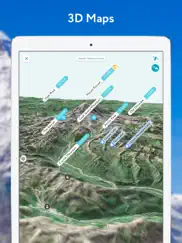
● 3D Maps
As human athletic achievement progresses in the mountains, so does the technology to assist your adventures. With PeakVisor, you unlock the topo maps of the future; our cutting-edge technology with high-precision terrain modeling offers deep insight into the mountain landscape of your choice. With one glance, you be blessed with years of knowledge about an area’s terrain.
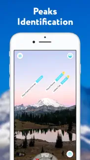
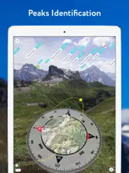
● Identify Peaks
Identify more than a million mountains, hills, buttes, spires, and more from all over the world, with a detailed profile for each of them! Our app shows you altitude, topographic prominence, mountain range, national parks or reserves, as well as photos and additional Wikipedia articles.
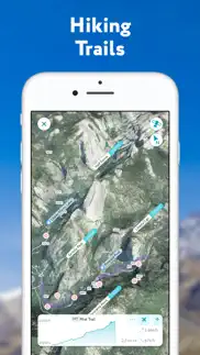
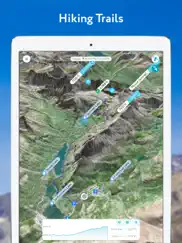
● Plan Hiking Routes
A vast network of worldwide hiking trails and walking pathways included in PeakVisor’s 3D Maps will help you compose a hiking route which includes evaluating the distance you can expect to hike as well as a route’s elevation profile and estimated time for completion.
● Skiing
In winter mountain sports, PeakVisor’s topographic 3D Maps allow a visual understanding of the terrain and provide detailed information about mountain lifts, ski resort trails, and backcountry ski touring routes. The app also offers features such as winter mode and a slope steepness overlay to identify avalanche terrain on your route.
● Cable Cars and Mountain Huts are inlaid onto our 3D Maps, complete with schedules. This is especially useful in Europe, where many objectives involve a cable car ride to gain some altitude, lest you want to do some genuinely punishing climbs. And you haven’t experienced the old-world mountain culture until you’ve had a memorable meal and night at a rustic mountain hut in the high country.
● Peak Bagging
The app offers monthly climbing challenges and Peak Bagging competitions to keep the motivation where it needs to be…UP.
● Animated Flyover Videos
You can even initiate a ‘Flyover,’ our visually stunning animations that give you a token video of your route to show family and friends or inspire some memories down the road.
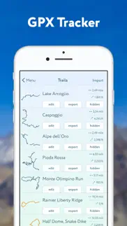
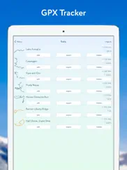
● GPS Tracking
Track any outdoor adventures, whether hiking, skiing, mountain biking, etc. Post-adventure, you can visualize your route in the miniature 3D world, check out stats like distance and elevation gain, and export a GPX file of your new route.
● Lock-Screen Navigation
● All Features Work Offline
PeakVisor is the Swiss army knife for outdoor adventure, one that you will soon find indispensable while in the mountains. With so many features at your fingertips, you’ll find value from the app whenever you're on the trail.
PeakVisor PRO is a premium subscription that allows you to use the app without any limitations. By subscribing to PeakVisor PRO you make it possible for us to focus on the continued development of the app. PeakVisor PRO is available as a monthly or annual subscription. We have no advertising on the app; all revenue comes from our user subscriptions. We constantly modify the app and offer an update each week, always with new features and fewer bugs. You may find more details in our Terms and Privacy Policy by the link → https://peakvisor.com/en/terms.html
😍 Do you love Hiking & Skiing - PeakVisor app? Please share your friends!

Please wait! Hiking & Skiing - PeakVisor app comments loading...
Hiking & Skiing - PeakVisor 4.101.2 Tips, Tricks, Cheats and Rules
What do you think of the Hiking & Skiing - PeakVisor app? Can you share your complaints, experiences, or thoughts about the application with Routes Software SRL and other users?

Hiking & Skiing - PeakVisor 4.101.2 Apps Screenshots & Images
Hiking & Skiing - PeakVisor iphone, ipad, apple watch and apple tv screenshot images, pictures.
| Language | English |
| Price | Free |
| Adult Rating | 4+ years and older |
| Current Version | 4.101.2 |
| Play Store | ru.routes.peakvisor |
| Compatibility | iOS 13.0 or later |
Hiking & Skiing - PeakVisor (Versiyon 4.101.2) Install & Download
The application Hiking & Skiing - PeakVisor was published in the category Travel on 21 December 2016, Wednesday and was developed by Routes Software SRL [Developer ID: 1164817640]. This program file size is 121.98 MB. This app has been rated by 10,279 users and has a rating of 4.5 out of 5. Hiking & Skiing - PeakVisor - Travel app posted on 05 March 2024, Tuesday current version is 4.101.2 and works well on iOS 13.0 and higher versions. Google Play ID: ru.routes.peakvisor. Languages supported by the app:
CA EN FR DE IT JA KO PL PT RU ZH SK ES ZH Download & Install Now!| App Name | Score | Comments | Price |
| Routes Tips - travel inspiration tailored for you Reviews | 1 | No comment | Free |
| Bergamo Quest - Unconventional tourist guide Reviews | 5 | 1 | Free |
| Denoise - audio noise removal Reviews | 2.5 | 136 | $1.99 |
| Deshake - Video stabilization Reviews | 3.3 | 189 | $2.99 |
Introducing our new weather forecast feature, now available for any hiking location of your choice. We've also added snow depth details to the 3D map. Plus, don't forget to check the app to find out which mountain huts are currently open! PeakVisor has included mountain huts on its 3D Maps for years. This week, we expanded this feature to include whether or not the hut is open and closed, as well as schedules for dining and overnight stays. Our dataset now includes thousands of huts, with more added weekly. The latest version brings us one step closer to PeakVisor’s goal of being a one-stop shop to plan an adventure. With the new version you can photos captured in the app are saved in HDR on devices supporting that. Also fixing a bug with vanishing tracked trails from the recent update. New crash fixes and KML import improvements with trails following terrain curvature.
| App Name | Released |
| Lyft | 30 May 2012 |
| Southwest Airlines | 17 December 2009 |
| Enterprise Rent-A-Car | 03 October 2015 |
| U-Haul | 25 May 2015 |
| Vrbo Vacation Rentals | 19 July 2017 |
Find on this site the customer service details of Hiking & Skiing - PeakVisor. Besides contact details, the page also offers a brief overview of the digital toy company.
| App Name | Released |
| WikiCamps Australia | 01 March 2012 |
| Bonaventure Cemetery Tours | 06 May 2020 |
| US Public Lands | 11 April 2014 |
| Texas Historical Marker Guide | 25 January 2015 |
| Walmart Overnight Parking | 29 January 2010 |
Discover how specific cryptocurrencies work — and get a bit of each crypto to try out for yourself. Coinbase is the easiest place to buy and sell cryptocurrency. Sign up and get started today.
| App Name | Released |
| Telegram Messenger | 14 August 2013 |
| Google Chrome | 28 June 2012 |
| Duolingo - Language Lessons | 13 November 2012 |
| DramaBox - Stream Drama Shorts | 18 April 2023 |
| X | 09 October 2009 |
Looking for comprehensive training in Google Analytics 4? We've compiled the top paid and free GA4 courses available in 2024.
| App Name | Released |
| True Skate | 18 October 2012 |
| Purple Place - Classic Games | 17 May 2019 |
| Ultimate Custom Night | 28 April 2020 |
| Bloons TD 6 | 14 June 2018 |
| AnkiMobile Flashcards | 26 May 2010 |
Each capsule is packed with pure, high-potency nootropic nutrients. No pointless additives. Just 100% natural brainpower. Third-party tested and validated by the Clean Label Project.
Adsterra is the most preferred ad network for those looking for an alternative to AdSense. Adsterra is the ideal choice for new sites with low daily traffic. In order to advertise on the site in Adsterra, like other ad networks, a certain traffic limit, domain age, etc. is required. There are no strict rules.
The easy, affordable way to create your professional portfolio website, store, blog & client galleries. No coding needed. Try free now.
Hiking & Skiing - PeakVisor Comments & Reviews 2024
We transfer money over €4 billion every month. We enable individual and business accounts to save 4 million Euros on bank transfer fees. Want to send free money abroad or transfer money abroad for free? Free international money transfer!
Pro version required!. Upon installing the application I was notified that I would need the pro version in order to locate peaks in more than one location per day. Seemed fair enough, I likely won’t usually need to use this more than once a day but I figured I’d sign up for a year membership if I enjoyed using the free version. I entered into the app to try it out and learned that I needed to download data for my vicinity, 130mb.. Seems like they must be doing something pretty inefficient to require a file that large for everywhere you go (and certainly makes it impractical if you have low cell service, like for example in the mountains lol) but I allowed it just to try it. While I am waiting for the information in my vicinity to download I am prompted that I have used up my one location for the day and must pay to view more. So essentially, I spent my free location for the day downloading unnecessary data (even though I was still in the same location lol). Pretty sweet! Looking forward to checking out other options or writing my own app for this.
Biggest mountain missing. I live in the Blue Ridge area of N. Carolina and hike every day that it is fair out. It was very strange that the areas largest Mountain (Grandfather) was totally missing. Others were not in the right place comparing with geological maps. I hike Rich Mountain yesterday and it was missing altogether, even though it is the largest in the immediate area. I pretty much have given up on this App.
It’s Like Magic!. Very Cool App. I’ve been doing these mountain identifications for years in photos using Google Earth and painstakingly going through a manual process. Now, I just get them all label automatically with nice labels and detailed information. It’s like Magic!
Fantastic Application!. Just love the application. We live in a mountainous area and it’s wonderful to have this tool. It also very much enhanced our experience on a recent trip to Glacier/Waterton Lakes and Grand Teton National Parks. Unbelievable how much capability we have in such small devices these days. Great job to the development team!
Great visual app. Well designed app. I really enjoy using it, especially now that I upgrade to the pro version. Only complaints are I can only select 1 gpx file at a time to upload (tried from phone, tablet and web browser, all have that restriction) which is a painfully slow waste of time. And I experienced crashes on a base model iPad.
I DETEST SUBSCRIPTIONS!. Please just figure out what a fair price is for the app (high or low) and I’ll pay it. I am overwhelmed with monthly subscriptions and will not buy anymore. I would gladly pay whatever you consider a fair price to own it. It’s getting out of control. Too bad because it appears that the full version is amazing. :( 9/4/21 Any consideration given to a one time fee? If you think people would be deterred due to the price I think you would be surprised. Of course you can keep the monthly/annual purchase option, but I want a one and done price. After spending a little bit of time with the free portion of the app I am sure it is worth whatever you would need to charge for a on time fee. Tanka for considering this request.
Major Midwest USA Improvements (20 May 2023). Able to find watershed lakes, rivers & streams plus outdoor recreation biking & hiking trails. Seems to synchronize with online PeakVisor Portal via Safari Browser using iPadOS 16.5 … Unable to access or delete simulated 3D Flyover videos.
Great app. This app has managed to tackle some really interesting obstacles. In order to get the right information in the right place. This app could easily cost more then it does! It’s a major value add to my life here in Colorado!
Frequent crash with latest release. I'm facing frequent crashes when playing in 3D map.
Great app!. Mind-bendingly cool app! Feels magical to see the topography of any place you stand on earth outlined and labeled. Adds greatly to my enjoyment of hikes in the Olympic an Cascade mountains. Definitely worth spending the time to get to know the features. Email support was super responsive.
Black Mtns WNC. “Just open the app and point the camera.” Sounds easy. I’m in the highest mountain range in the Eastern USA, the Black Mtns in Western North Carolina. I’m 4.01 miles from Mount Mitchell (measured with my Garmin GPS), the HIGHEST PEAK in the Eastern United States, and after nearly a dozen tries, this app has identified NOTHING, although it did indeed download the data it needs for this area. I can clearly see Cattail Peak, one of the southern sixers, from my property. It’s barely a mile away. When I aim the camera at Cattail Peak, the app provides no data whatsoever, even after adjusting and readjusting numerous times, as the user is prompted onscreen to do. After trying over and over, all day long, all I’ve gotten is crude line drawings of mountains. GPS data, yes, but no peak data whatsoever. Nothing. Zilch. Nada. The instructions, which I’ve read, reread and reread, over and over, provide no help whatsoever. Only brief and cursory explanations. Sorry I wasted my money.
Utah traveler. I am on vacation in Southern Utah and said, “wouldn’t it be nice to know what mountains and geographic features I am looking at?” Well guess what, questions answered. Thanks to the developers for such an amazing app. Could not be happier! Even used the teleport feature to go back to park I have already been, and identified mountains that I wondered about. Great product!
App is good but maps downloader needs a LOT of work. On even the fastest connection downloading maps takes so long it basically is a useless feature. Either their maps/tile server has severely underprovisioned networks or there is a rate limiting bug. 10-15k/s at most for 1Gb+ is never gonna work. All other apps download at full speed, so it’s not my connection! This may seem like a small detail but the app is useless in the backcountry without offline maps!
Head to the Hills⛰️. The navigation, on the spot coordinates and remote, teleport feature, fly-overs and photo imports oh my! The best part is the thousands of peaks to discover. Where will you go next? Easily navigate trails today! Thanks Denis!
Free version is useless. It worked once at my home. I waited a few days to try a new location since the “one location a day” paywall came up. Can neither load in a new location or determine what location is being used as it won’t load at home any more either. It’s just a bricked app now with no functionality asking me to pay a cup of coffee every month. I don’t drink coffee. And I don’t believe in never ending subscription models without any guarantee of new services.
Great. I’ve been backpacking in the mountains for about 30 years using Maps then handheld GPS and phone enabled GPS, and I just added this product to my quiver. I really like it a lot. The core functionality is that it lets you superimpose the horizon line and the names of peaks onto your phone screen when you have your camera viewfinder enabled. This works well and I have learned the names of a lot of features that I have been looking at for years without knowing what they are called. You can download these photos with the labels on them. You can also upload a picture and The app will add labels— assuming the photo is geotagged. The final feature that I will mention is the virtual terrain mode, which allows you to “see over” ridges. All this has really added to my understanding of the mountains that I backpack in southern Idaho. Highly recommend.
Can’t identify mountains. I used to use this app all the time but now every time I open it it stares blankly at me while trying to access wifi to “download vicinity data”. Not sure about most people but if I’m looking at mountains I don’t have access to wifi. I’m lucky if I have access to cellular.
completely inaccurate. while using this, the app would change its mind about which peaks were which without me even moving the phone at all. when i did move the phone, it would tell me the same peaks regardless of whether i was looking east or west. maybe it couldn’t identify peaks because there were clouds behind them, or maybe it is just bad at WNC (I see someone else had issues around Mt Mitchell). Glad i didn’t pay for this lol
Works great. I used the app when backpacking in Yosemite Np. It showed names and detail of all the peaks that appear in my real time camera and even some peaks that were behind objects. Of course I had to download offline data of Yosemite region before hand. Overall I think the app deserves 5 stars because It helped me a lot in backcountry
Awesome. Works great! This is a must-have for any mountain enthusiast. Albeit it does not suffice for a quad map or good gps, it does provide great information and pinpoint location of peaks. I am told that next version is in near future with more great functions. Hint to developer: I would like to see glaciers added. Also a function to mark peaks that I have achieved with dates and notes. This would be a great peak-baggers journal!
Garbage. Insanely slow to load. It just sits on "composing panorama" for several minutes and then crashes. I'm on an iPhone 13 so it's not a slow phone. If you want to identify peaks from the passenger seat if a car before they go out of view, this isn't the app for you.
Wonderful, but know that it uses a lot of data.. Update: The developer has explained that the data is necessarily large but that it can be pre-downloaded at home to save data quota. Since that was my only complaint I've upped my rating to 5-stars. Users on a measured plan should understand that the the app will pull a lot of data in the field if it hasn't been previously downloaded. It really is quite amazing at identifying peaks - point and shoot! - and I feel bad about dissing it. But in 3 or so minutes, over a less than 30 degree segment of the horizon, it just blew through my - admittedly low, 100MB - entire monthly data allowance. This won't be a barrier for most people but those light-users on a measured plan, as I am, should know upfront: expect a hefty download to do what it does.
Great tool. This is really a wonderful tool. It’s still evolving so it will only get better. The user interface is not instantly intuitive — for example, the great 3D hiking/terrain maps are displayed by double tapping the compass. Who’d have thunk to try that? But already a great travel companion. I haven’t really used it in the field yet but have high hopes based on test usage so far. I’m optimistic for steady improvement.
Would like to use manually. Many would like to use the app manually with location services turned off, giving the ability to research and explore. This app is completely inoperable unless it is turned on.
Difficult to use. Cumbersome… Very cumbersome to use. This is a very difficult out to use and continually wants to “download the vicinity“. I quickly grew tired of every single time I opened the app it wanted to “update“. It uses an outline type system that you have to line up with the peaks that can be cumbersome if you are at any sort of distance.
Doesn’t work in my area. I love the detail and graphics but could not get the app to work. It had some of the right peak names but put them in the wrong places. For example the roofline of a nearby building was identified as Mt Guyot. Other major peaks like Quandary were nowhere to be found even when I had the camera pointed at it.
Great and useful app. I love Peakvisor. I hike in the Adirondacks, and I’m never quite sure which peaks I can see from my location. Peakvisor makes it easy! The developer is very responsive; I asked a question and he replied in a few hours. A great app, and new features are added frequently.
If you’re a hiker/geography nut, you’ll love this app.. I love this app. I use it all the time on hikes. If you’ve ever wondered, “hmmm... what is that mountain over there” you’ll like this app. I’ve downloaded all the mountain ranges that I frequent. It helps me have a better idea of which mountains I want to climb and where they are in relation to myself. Great app!
Great app!. If you love mountains, peaks, valleys, creeks, etc. and hike a lot, this is the app for you. I use this app along with other apps like all trails and google to find new parks and hikes. I like the travel logbook feature as well. Great app.
It’s a cool app!. This app is really useful, not only when hiking up in the mountains but also when just driving around. It labels the mountains wherever we are, even above the cloud. It’s a cool up.
Will not open. Crashes repeatedly.. His concept is very cool. I spend a lot of time in the mountains and love identifying peaks. This will come in handy........if it will ever open. It crashes every time. It appears to be downloading some files to run and hard crashes. I have yet to use the app. I have an iPhone 6+. Would rate higher if it actually worked.
Awesome for Peakbaggers!. I’ve climbed nearly 40 mountains, just climbed my first with this app on my phone. It added so much to the experience. I can look around and get a bearing on exactly where I am and what I’m looking at, as well as what is over the next hill that I haven’t been to yet. Just Great!
So far, so good! (Edited 3/8/18). Downloaded the app, open it and the screen constantly flickers. Apple should offer refunds for apps that are junk and purchased from the App Store. If I could give this 0 or negative stars, I would. *updated 3/3/18* I downloaded the latest update and so far the app is working very well.
Issue resolved. After initially having some tech issues the developer reached out to Me and the issue had been quickly resolved.
Missing standard feature. Great app, but missing landscape support. Only portrait mode is supported in the interface. While the app make “look” like it supports landscape mode, the interface demonstrates that the app still thinks of itself as only in portrait mode. This is seen with the startup screen and the subscription sign up screen... along with other visual components. Functionality is impaired on the iPad Pro 12.9 (3rd gen).
Amazing tool for learning the mountains. I have been very impressed with the breadth and abilities of this app. It has become my go-to tool for learning about the topography of mountains in California. Many times before this app, I had wondered what mountains I could see. This app makes incredibly easy to find out. Before going on trips, I enjoy using the teleport feature to see the layout of the area. You can see relatively detailed images that give you a good idea of how your path will look from each position, so it’s useful for back-country treks where good trails aren’t available. The new 3D feature is very useful here as well. There are actually quite a few trails uploaded here too, so it is useful when you want to find the direction to a trail. Both live and picture-based landscape matching work really well. I appreciate the download zone option, since there isn’t always service in the mountains. The landscapes are surprisingly accurate, and all of the features are easy to use.
Happy for now!. Had a 1 star rating because of the subscription change and thought I’d be losing offline access in a year. The developer made it clear, via email, that nothing changes, at all. So, for now, 5 stars. Great app, always love using it while out in the woods!
The world of mtb thanks you. This is the most incredible app. It’s been years since I’ve downloaded an app with this much detail and accuracy. An app worthy of the price.
(Free version) “One location per day”?. The app seems to work beautifully, but I would not have expected the “one location” limitation to lock me out during an hour’s loop walk around the Viewpoint neighborhood in Prescott Valley Az. I downloaded the “area data” before starting out. What’s a ”location”?
Will kill your iCloud backup. Nice app, but for reasons that escape me, the developers think they need to backup all data (approximately 840MB) to my iCloud account. Since I could presumably just download this data again if my phone was lost or damaged, I can only assume the devs are getting a kickback on the $ I now have to spend on extra iCloud storage. As one developer to another, here's a pro tip: just backup a description of what I have downloaded, not the entire download itself.
An exceptionally useful tool!!. An excellent app for learning the names of visible mountains in your vicinity. The app is easy to use and offers an outline of the peaks you’re viewing that can be moved and aligned with the camera image of the peaks to accurately position the labels on each mountain. If you live near mountains, this is a must-have app. It’s intuitive to use and saves photos of the peaks you label for review later. The only drawback is that the free version can only be used in one area per day. If you’re moving through several locations in a day (e.g. driving for an hour or more through several sets of mountains) you need to subscribe to the Pro version of the app.
Great app!. I love this app! It is quick and easy to use and gives detailed info either in real time or with photos. Tech support is awesome and gives one to one service. Recently had a bug and the support was tenacious and persistent in figuring out the problem. I highly recommend.
Fun to use and awesome customer service. Love knowing the peaks and additional info for where I live and when we camp. I noticed one peak’s height was incorrect, so I emailed the developer and he responded within a couple of hours and fixed it!
Great hiking app!!. If you have ever been on a hike or been anywhere that there is a view of mountains in the distance this is an awesome app to help you properly identify surrounding peaks. I have not used it yet for orienteering or mapping out hiking routes but I would think would be incredibly useful. I emailed the developer with some follow up questions and they responded right away which is much appreciated. You can download regional maps so that you don’t need to depend on active connectivity which is definitely required when you are off the grid. If you are always staring at the horizon and wondering what mountain or hill is the distance then this is a must app for you!!
Did not work offline. While hiking in Colorado, I tried to use the app to name some peaks I already knew. Wanted to see how well it worked. Well to my surprise, I got an error message stating I didn’t have internet service, duh, and I would have to upgrade to the Pro version to work offline. So pretty worthless app in my opinion. Fix it and I’ll try it again.
Nice design, horrible execution. I wanted to test this app to see if it’s better than the one I’m currently using. So I’m up in the mountains and I load it up. Takes a while to download and stitch the panorama. And then nothing shows up, at all. So I restart the app, and wait again, and then the outlines of the mountains are in the sky, like way up in the sky, and the horizon isn’t even level. Whatever I used my other app. So a couple hours later I try to give this app a second (third) chance, and it’s locked out! One location per day. Wow great job guys.
Would be PERFECT but.... Love everything about this app except the way it updates. For some reason nearly every time I try to use it, it needs to update the data by downloading the vicinity. Of course this is always exactly when I’m on the trail without data or wireless available. This app beats the competition in about every other way by leaps and bounds so I hope they fix that!
Great, but. Too expensive for occasional use. Would like to see a second, paid app released for something like $9.99 and an annual fee of $3.99. Until then will stick with Maps 3D
Incredible detail. I’ve used PeakFinder AR for close to 7 years (before there was decent AR) and only last summer decided to check out Peak Visor and wow. In the decade since early mountain and star identifying apps first made their appearance on the iPhone, apps like Peak Visor have taken the concepts and massively expanded upon them. For one, greater CPU power has allowed beautifully rendered graphics, and greater accuracy in the graphic overlay HUD that pops over the mountains. In Peak Finder, you had to open the “camera” function to see the tags over the actual mountains themselves which was a real pain. But even more incredible is the 3D map you can double-tap if you point your iPhone down. It’ll not only let you teleport anywhere in the world, but really let’s you explore topography that’s difficult to physically reach, with dozens upon dozen of mountain tags; even in the most remote parts of the British Columbia or south-eastern Al. You can also preemptively download vast swaths of the planet you expect to go exploring in before you arrive, so when you open up PV, it’ll instantly have a ton of data to give you. Coupling this app with Gaia/AllTrails and Google Earth has been real game changer for me, and even when I’m just driving down the interstate, if I see any mountains that catch my curiosity, I instinctively pull for this app. It’s become that integral to me. Perfect 5 stars, we’ll worth the cheap price.
We found the mountain. We were at an observation tower and saw a mountain and wanted to know which one it was. The app helped us find it in like 5 mins and it was free and pretty easy to figure out. We found Sugarloaf Mountain.
Did you know that you can earn 25 USD from our site just by registering? Get $25 for free by joining Payoneer!
Awesome uptil the update. Initial experience from months ago superb, failing to provide consistent menus and improtu professional recommendations are ignorance of what I wish to achieve
Brilliant!. I am in Nepal and found that PV easily detects the peaks around me. Some of the guides are not clear which peak is which. I live in Western Australia and expect PV to be equally good at detecting named peaks while out bushwalking - even though not snow capped! The backup from the developer when I was having issues in Nepal without a local SIM card was second to none. Thoroughly recommend.
Free version limited to one location a day. Subscription required. Free version is limited to one location a day.
Incredible App, does what it says on the tin. I am very impressed with this app. Incredibly powerful...amazing.
App crashes constantly. App crashes constantly after about a minute of use.
Imagine you at your best. All the time. Picture yourself at your sharpest and most productive. Your most alert and focused. Your most lucid, creative and confident. At work. At play. In every area of your life. Add Mind Lab Pro® v4.0 to your daily routine and uncap your true potential. Buy Now!
Free version is useless.. I just want to identify peaks from a distance. When trying to calibrate the AR with my camera it shut off saying one location per day.
Drains battery. Not as good as the preview, uses lots of the phone battery so not ideal to track or use in hikes. Phone heats us when app is open. Not worth paying for, would not recommend.
Would be good if it works. Doesn’t work that great. Mountains that I 100% know the name have the name attached way off course. And it does not work offline as described
requires too many acess. otherwise you arenot allowed to use it. hard to use
Frustrating. Ever since I first got this app over a year ago I’ve been frustrated by it. It never works properly. It doesn’t take the photos in app with the silhouette over the proper spot even when I centre it perfectly. It doesn’t include many labels and sometimes the silhouettes move and sometimes they don’t. I feel angry every time I use it. Waste of my money.
Accurate & beautiful (and fast). I saw an ad for this app while checking out PeakFinder Featured Story (kudos to your marketing team ;-) and I am sure glad I did! Its a really well done app, which has all the features I want packaged in a beautiful and simple UI.
wow.. totally amazing app. if you are into hiking or just like to look at the horizon, this is a must have. try it; the app will sell itself.
Invermere BC. Beautiful absolutely beautiful. Thank you
I really want it to work!. I downloaded the update and am running ver 10.2, it keeps crashing! I would love this app to work without crashing.
Not working for me. It shows the mountains further back from the ones I’m looking at. It won’t label the ones closest to me. Very frustrating.
Unreliable. Compass keeps changing making this app worthless.
Best app for hiking. I love the hiking trail interface of this app and the extensive database. Allowed me to explore little known trails (and amazing view points!!) in Norway that I otherwise wouldn’t have the confidence to. Some of these spots are hidden right beside popular tourists spots with 100x the views and literally two or three people on the entire trail. Hope the dev team will continue to expend the database of trail and viewpoints and other hiking features (a better ar trail map overlay maybe?). Great job! Most valuable app I ever paid for.
Great Concept!. The updates to the app have really helped, and I've had really good luck identifying peaks along the Sea to Sky. I always got them confused before, even looking at a map, so this is really nice. I have trouble getting it to recognize mountains when there are things between me and them, at the base. Buildings throw it off, but it still makes a good attempt. When I've got nothing extra in between, it works great! I'd still like to be able to use photos without turning the location on for them, but I get why it won't. Definitely working better than before, and I'm looking forward to seeing where it goes from here! --- Original review (2 stars): App shows every single mountain in a general direction as a point. I'm in Vancouver, it's showing me Stawamus Chief... in Squamish, an hour away. I definitely can't see it from here. It doesn't seem to matter how close or far away, it's not giving me what's in front of me. The photo recognition doesn't accept any jpg photos I have as being valid file types. And the instructions aren't helpful at all. Honestly, this app sounded so good, but I regret spending money on it. Wait until they get this working before buying it.
Waste of time. I downloaded and opened, Matterhorn screen appeared and seconds later went black and shut down. I figured something happened during download, so I deleted and then installed once more. Same thing happened again. Total waste of time and data.
Love it. We have lots of mountains around here. Always wondered what the names of the peaks were. Love that you can use it offline or on pics you've taken. :)
Doesn’t work. It was completely off by a long shot, it was saying lasquetti island was little mountain on Vancouver island. Lol
Crap. Tried to use my once a day location. App crashes and told me I had to pay for pro to use the app. Yeah right.
Adsterra is the most preferred ad network for those looking for an alternative to AdSense. Adsterra is the ideal choice for new sites with low daily traffic. In order to advertise on the site in Adsterra, like other ad networks, a certain traffic limit, domain age, etc. is required. There are no strict rules. Sign up!
Useless app - no match of app to real mountains. I’m in Les Masses in the Alps and even after downloading over a thousand blocks of data, there is no range I can point at where the labels match the mountains. The artificial horizon is also in the wrong place.
One location a day?. Was trying to drive around and see all the peaks in my area when i was told i couldn’t use the app any more. Guess i’ll just delete it then.
Great app!. If I lived somewhere more mountainous or traveled more, I’d probably pay for it.
Meh. Pretty sure I paid $5 to download this, got partway to the top of a 14er, spending my apparent one use a day without a membership so I couldnt use it a couple hours later at the top. Why did I pay $5 in the first place.
1 use a day?. Only one use a day before having to pay $23/ year. Not too happy. Hard to tell how this is working b4 I pay other then the reviews.
Cool app. Only thing is when driving it’s slow to identify the ranges .
Slow. Very slow to download vicinities. Can only use within excellent cell range and well, if you’re in the mountains, you likely aren’t within good cell range.
I use world peaks. I use world peak because you have to have premium to do a lot here
Don't buy subscription.. I ve got a subscription and had it active. Went on a hike and the app was asking to unlock "pro" version. Seems like scam.
Too difficult to read. I have the free version. The mountains came up but the print was so small I couldn’t read it.
Shady Company Practices. I bought the app with no expectations of having to pay for a subscription. Now we’re being told we have to pay for a subscription to receive all features. Buyer beware.
Not worth the hassle. The free version is incredibly limiting on a per day usage. So I just said, ok, I’ll splurge, because I’m new to the Pacific Northwest and have a drive through the cascades that I’d love to identify peaks. It’s been terribly inaccurate the entire day. A huge waste of money for me, and no option for a free trial or monthly subscription.
3.55 version problem. Hi, been using your app. Has been working great. Updated today to version 3.55. Tried to open after update and home screen shows up. App does not work now. Running IOS 12.5.1 on an IPhone 6. Help! Lenny
Can’t read. Print is too small
Pick your use. I read a glowing review of this app, so I downloaded it and tried it today. I couldn’t get everything to lineup and so I decided to try it later, but you can only use it once a day! Worthless-glad I didn’t pay!
This Will Get a Lot of Use. We just moved to the North Carolina on the side of a mountain and plan on doing lots of exploring. So far it works great.
Hard to figure out. I was so excited about the app but it is not as user friendly as it looked on the trial. I thought you could point it to a mountain peak to identify the mountain but I am not finding it that easy to use now that I have subscribed..... sorry I am just a beginner.
Dud. We have tried using this while hiking and it never shows any of the mountains we know that exist in our area. It mis marks all the peaks we point it toward. We are in Wester Massachusetts.
Terrible. Why does this app need camera access if I only want to use it to upload pre-taken photos?? And why does it need the compass calibration setting change in Privacy when again I only want to use the app for pre-taken photos??
Seems like junk to me. In the middle of the colorado rockies, it misses most peaks. Leader lines between names and peaks are grossly misaligned. Names are too small for anyone who needs reading glasses to read. Try again, folks. Even near Vail, between Sawatch and Gore ranges, this app was pretty useless.
Peaks. We are having a problem with the peaks moving around a lot, so not to accurate. Adirondacks
Peaks off by 5-60°. Worked great once; second and third times the peak IDs were off by 5 and 60°. Uninstalled.
Real Estate tool. I occasionally accompany my wife when she shows real estate here in the mountains of WNC. Great tool and conversation piece, show mountain tops in the vicinity of properties.
😡charged day *before* cancel date. If you’re going to check out a “free trial”, beware that they will auto-charge you even if you do cancel *before* your next subscription period is clearly scheduled to begin.
Frequent crash with latest release. I'm facing frequent crashes when playing in 3D map.
Have to subscribe to use more than once a day. You have to subscribe if you want to use this more than once a day. When I downloaded the app around 12:30 am, it automatically used my “free pass” for the day.
Really worthless app. Even as a mountain activity enthusiast who’s traveled the world over for treks and ski outings, this app is a perfect example of the world having way too many worthless apps that are nothing but data collecting scams. DELETE.
Very slow. Slow to load
3D terrain maps w/trails simply beautiful.. Much improved since last year when I only used this app for identifying leaks.
Waiting for this. Every hiker wants this - I now know what that peak is! Thanks
Far from perfect. For $30/year, you would think it could identify Ben Nevis when you’re looking right at it. After all, it is the tallest munro in the British isles.
Can’t identify mountains. I used to use this app all the time but now every time I open it it stares blankly at me while trying to access wifi to “download vicinity data”. Not sure about most people but if I’m looking at mountains I don’t have access to wifi. I’m lucky if I have access to cellular.
Amazing apps !. Useful and incredible apps for hikers . keep it up !
Great app and fantastic support. New release fixed all issues
Switched to a subscription model booo. Disappointed that this detail was buried waaaay down in the end of the release notes. I hit "update" after reading the first couple paragraphs, now I'm deleting the app. Bye forever!
This app is amazing!. Easy to use and chock full of data. Wow!
identifying peaks. i hike in the mountains and really enjoy identifying the peaks surrounding me. It gives me a sense of where I am and where I am going.
The outdoor AR app you’ve been waiting for!. Title says it all. Really worth every penny and customer service is even better!
Great app, slow to load. Great app, love the content but very slow to load
Great but missing a few peaks. I can name all the peaks I live around. Maybe it’s just the locals names for various humps and such. But it would be cool to be able to add a few
Too expensive. Would buy for 30$a year. Too expensive would buy for $30 a year
App won’t open. I liked this app but it no longer opens. It flashes a load for like 2 seconds and then just crashes and closes. No error message, nothing. Tried uninstalling and reinstalling, still doesn’t load.
Thoughts. I downloaded this app and find it very nice, but considering it is a paid app (4.99) it is overly restricted. I used the app in the morning on the Grand Tetons, I moved locations with a different view of the Tetons and the app indicates I can only use it from one place a day, and I have to upgrade to the pro version for 30 dollars annually, which is unacceptable. Thanks for reading.
Get Peakfinder instead. Developer trying to squeeze more money out of you with a subscription for important features that you can get with a one time purchase with PeakFinder. It’s a really slimy move to take a one time payment app, turn it free and lock features behind a subscription. Never giving you a cent.
Boycott Subscription Apps. Buy once and own. PASA = People Against Subscription Apps 700,000 and growing. Add a worthy update, I’ll gladly pay for it. But to pay for the same app month after month is a rip off. Make me pay by country, gladly. $1.99 to scroll the Himalayas, no sweat. Heading to Ecuador to climb, instant purchase (and yes, I am). Would have been cool. Not going to happen. Let me buy areas of interest. But just to use all the same “Pro” features, forget it. Disappointed and Deleted
Poor coverage. At least half the time I can’t get a reading.
App will not open. Well can’t review the app since it won’t open. Download and when I click Tom open it shows the Matterhorn and height and then crashes. Tried over a dozen times. Guess I won’t be using/buying this.
Doesn’t appear to benaccurate. From Plattsburgh NY, looking due east, it shows Whiteface Mountain(west of us in the Adirondacks), as being right in front of us. Ran compass cal, but no change. Something is not right, could be me, but I don’t seem to be able to make it work
Excellent app. This app is fun, well designed, and educational. I often wonder what the mountains around me in Montana are named when traveling. Now I know.
When it worked it was cool. When in RMNP there was not good enough cell service to download the map. That was disappointing. When I had strong service it did work but I had really wanted to use it in the park...I cancelled my subscription