Wyoming 511 App Reviews
Wyoming 511 App Description & Overview
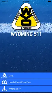
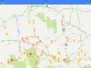
What is wyoming 511 app? Wyoming 511 is the official road condition and traffic information app of the Wyoming Department of Transportation (WYDOT).
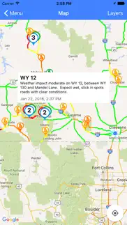
- Provides pre-trip map-based road and traffic conditions (Map)
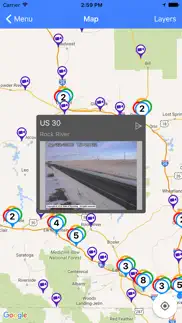
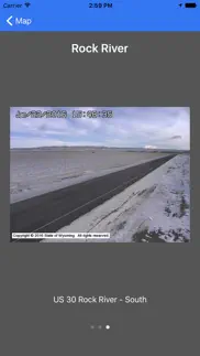
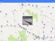
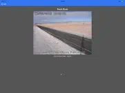
- Displays web camera images (Map)
- Displays weather station data (Map)
- Shows users their route and mile marker location, and includes latitude / longitude (Where Am I?)
- Speaks conditions so drivers know what they can expect on the road ahead (Hands-Free / Eyes-Free)
- Alerts drivers to traffic information, including crashes and other hazards within a user-specified radius (Hands-Free / Eyes-Free)
- Updates data from WYDOT’s servers every 15 minutes when a data connection is available
- Uses GPS to provide location-based reports
😍 Do you love Wyoming 511 app? Please share your friends!

Please wait! Wyoming 511 app comments loading...
Wyoming 511 1.5.6 Tips, Tricks, Cheats and Rules
What do you think of the Wyoming 511 app? Can you share your complaints, experiences, or thoughts about the application with Wyoming Department Of Transportation and other users?

Wyoming 511 1.5.6 Apps Screenshots & Images
Wyoming 511 iphone, ipad, apple watch and apple tv screenshot images, pictures.
| Language | English |
| Price | Free |
| Adult Rating | 4+ years and older |
| Current Version | 1.5.6 |
| Play Store | info.wyoroad.mobile.ios |
| Compatibility | iOS 13.0 or later |
Wyoming 511 (Versiyon 1.5.6) Install & Download
The application Wyoming 511 was published in the category Navigation on 01 February 2016, Monday and was developed by Wyoming Department Of Transportation [Developer ID: 1077881609]. This program file size is 51.37 MB. This app has been rated by 105 users and has a rating of 3.2 out of 5. Wyoming 511 - Navigation app posted on 08 March 2024, Friday current version is 1.5.6 and works well on iOS 13.0 and higher versions. Google Play ID: info.wyoroad.mobile.ios. Languages supported by the app:
EN Download & Install Now!| App Name | Score | Comments | Price |
In this version of Wyoming 511, a menu item has been added for current WYDOT job postings.
| App Name | Released |
| Find My Friends Phone - iMapp | 26 July 2014 |
| Citi Bike | 21 May 2013 |
| Footpath Route Planner | 07 May 2013 |
| Speedometer Simple | 18 November 2014 |
| Parking.com - Find Parking Now | 07 August 2018 |
Find on this site the customer service details of Wyoming 511. Besides contact details, the page also offers a brief overview of the digital toy company.
| App Name | Released |
| GPX-Viewer | 23 May 2014 |
| Phoenix Zoo - ZooMap | 19 December 2021 |
| MiniMap Radar | 20 October 2023 |
| Los Angeles Zoo - LA ZooMap | 10 May 2022 |
| Topo Maps | 26 March 2009 |
Discover how specific cryptocurrencies work — and get a bit of each crypto to try out for yourself. Coinbase is the easiest place to buy and sell cryptocurrency. Sign up and get started today.
| App Name | Released |
| Telegram Messenger | 14 August 2013 |
| CapCut - Video Editor | 14 April 2020 |
| Cash App | 16 October 2013 |
| 09 October 2009 | |
| PayPal - Send, Shop, Manage | 03 February 2019 |
Looking for comprehensive training in Google Analytics 4? We've compiled the top paid and free GA4 courses available in 2024.
| App Name | Released |
| 75 Hard | 19 June 2020 |
| HotSchedules | 30 October 2008 |
| AnkiMobile Flashcards | 26 May 2010 |
| Poppy Playtime Chapter 1 | 08 March 2022 |
| Incredibox | 27 March 2016 |
Each capsule is packed with pure, high-potency nootropic nutrients. No pointless additives. Just 100% natural brainpower. Third-party tested and validated by the Clean Label Project.
Adsterra is the most preferred ad network for those looking for an alternative to AdSense. Adsterra is the ideal choice for new sites with low daily traffic. In order to advertise on the site in Adsterra, like other ad networks, a certain traffic limit, domain age, etc. is required. There are no strict rules.
The easy, affordable way to create your professional portfolio website, store, blog & client galleries. No coding needed. Try free now.
Wyoming 511 Comments & Reviews 2024
We transfer money over €4 billion every month. We enable individual and business accounts to save 4 million Euros on bank transfer fees. Want to send free money abroad or transfer money abroad for free? Free international money transfer!
Needs a fix. Loved the app when it worked, but now it crashes as soon as I open it, while its updating the server data. I use iPhone 6. Hoping for a fix!
Won't even open. The new update crashes every time I try to open it
Slow to load. Even with new updates, there is quite the delay between launching the app and being able to view the map. Original review from July 4, 2018: It is slow to load the road data (I’m on a iPhone 7s and a fast WiFi connection) and it takes me to a menu first rather than just showing me the map.
Can you add mile markers as an option?. In the Map options tab, would it be possible to add mile markers as one of the layers? This could be very beneficial if there’s an accident or if there’s an issue reported at a certain MM and one could look for an alternative route.
Sure hope they don’t track and sell location like the Weather Channel app. Downloading now. Hopeful. So far WDOT’s twitter feed is the most useful thing. WDOT’s webpage is really hard to use on an ipad or iPhone. Not sure about the computer but I need it to work on my phone. While I’m stopped at a rest stop with minimal cell data. Roads need better labels for casual non-professional drivers. I’m really looking for a system to alert me of dangerous weather conditions on the road from Fort Collins to Laramie — that pass can turn nasty in an instant while road conditions everywhere else are fine. There must be a large number of kids and parents and shoppers traveling from Laramie to Colorado. Many are novice drivers.
Good app but needs a tweak!. As other user reported, map turns blue. If you don't allow the your Location to be set, the default is set to somewhere off the coast of Africa. So you have to scroll back to WY. If you allow your Location, you still have to scroll if you aren't in WY! Please set location to WY!!!!!!
Crashes Frequently. Every winter I redownload the app so I know what the roads are looking like while traveling. It's been very dependable for the last three winters; however, this snow season it crashes each time I select to view the map. I have always highly recommended the app, but with this issue I simply can no longer do so. I implore the developer to fix it quickly, as there are people who depend on this app to make safe travel plans and decisions.
Road conditions. Road conditions shown on app do not reflect reported conditions on wyoroad route for I 25 from Cheyenne to Douglas.
Too much clutter. When viewing the map, the numbers clutter up your view of road conditions. Get rid of them so we can see the roads and we can click on them to get more info.
We’ve used this for years- it’s a lifesaver. This app shows conditions on both local roads and highways. I wish there was a stated color legend, but it’s fairly obvious, and you can click on icons to see current alert and condition posts. Drill down to city streets is great. I notice that I have to reload this app if I have not used it in awhile— like most other apps. It works; an update in graphics would be good, but the actual detailed Hwy department data is indispensable. The trucker who went astray on the high elevation Beartooth Hwy should have been using this.
Not user friendly. Map is covered with numbers making it difficult to see. No way to remove the numbers layer and they don’t even serve a purpose that I can figure out. No legend
Good state run app. I drive the west coast and this is one of the better ones from a state. One thing I would like to see is the addition of a weather forecast, and incidents like on utah's. Overall a great app much better than the independent ones.
Nice to see.... Haven't played with it much yet. Looks like a nice design. You should seriously consider adding the ability to make ECAR reports through this app. Of course not while driving, it could add a bunch of real time data. Especially if there was the ability to upload a picture, or short video of road spots that are in bad shape. Let's face it plows and troopers can't cover everything all the time.
Lame.. Other than the coal closure map. This app is useless. I don’t even know if the closure info is correct. Lame
App crashes frequently - no way to update. This app crashes several times while using it. The other issue I have with it is you can’t manually refresh the data to see new road closures or other data.
Please fix. Whenever I check it once and get out of it and come back to it it crashes every single time.
??. App is not working properly on Iphone. Data downloaded is several “years old” map also does not load, no roads on the map either just a big blob. worthless.
Misinformation. This is a terrible app. Totally misinformed about roads.
Don’t trust this app. Just came from Buffalo to Tensleep. The app had notice of “Commercial Vehicle Testing Operations,” so we called Buffalo DOT Maintenance about expected delays and were assured we’d notice almost nothing. Nowhere on the app nor in our call was the 15-minute wait for a flag car nor the chip and seal operation with loose gravel that went from the Sheep Mountain Lookout Road to the Washakie County line with 45 mph speed limit. Nowhere was the 5-minute wait for flag car along Tensleep Creek with a drop down to mud for a short distance between the end of the canyon and Tensleep. NO INFO. Don’t trust this app. It’s not updated as it should be.
Nice Improvement over the past. This is way better than the website and phone in options of the past. I love the camera, weather sensors and road conditions. Great app for any Wyomingite!
When it works it’s ok. App crashes a lot. With newest update now the map won’t show the road conditions which is the main point of this app.
Tons of great info but.... It would be nice to plot my drive and filter out all the other reports that will not affect my course. Showing everything is pretty confusing.
Why?. Why are there no city or town or highway numbers on the map?
It's a start. It's an ok app to start with. Wyoming has an excellent system of highway signboards that don't appear to be available in the app ... yet. A great alternative app is Wyoming Traveler; that's my go-to app, and maybe one day the Wyoming 511 app will be as good, if not better.
Thank you. Thank you for putting the time and resources into making this app!
Crashes Incessantly Now. The latest update has made this previously indispensable app nearly useless with its constant crashing when trying to open the map feature. This is during a blizzard with sub-zero temperatures when knowledge of road conditions & closures is a life-&-death matter. Restore it to its previous usefulness, and leave well enough alone.
Not a good app. The app isn't as good as others have told me. I can't use it for checking the roads and mapping out where I want to go.
Blows. Have had this app for 2 weeks every time I try to open the map it just turns blue and doesn't load. I've tried wifi and even deleting and downloading it again still does not load map.
Update causing failure?. Since the update yesterday the 511 app crashes at start up on my iPhone and is very slow to start up on iPad .
Crashes on open. Crashes every time that I try to open the app.
Doesn’t work. I have the new iOS downloaded and now this app doesn’t work
Uploading. This app takes way to long to upload data so it can be referenced. I can wait for over a minute and it still doesn’t show the data.
Incredibly unstable. App crashes whenever I try to open the map. If, by some miracle, I get to the map, it will crash when I try to bring up the weather station layer. If I haven’t gotten tired of trying by this point, which is usually between 25-50 attempts in, it will crash when I try to open up the data from a weather station. Needs serious stability improvements.
Crashes. Crashes when I try to open it with iOS 11, please fix
Good. I gave it 5 because it’s quick and easy to know exactly what the conditions are for any stretch of road. Excellent.
where is a text based alternative?. For me, the map has only crashed. And crashed. And crashed. Reading reviews, it has been crash crash crashing for a long time. So I no longer have a way to find out how the roads are as I head toward WY. Good luck to all of us. We're on our own.
Well. I am sick of this app crashing every other day. Fix it.
Claim road kill does not work. I read a story that touted this new functionality on the app, so I downloaded the app. I tried to use the claim road kill function. The app connected me with the department of fish and game computer system and had me fill in personal information. I filled in the information and the system froze. I tried this many times with same result. Another poorly implemented government system. What a waste of resources.
Best App in Area. Title says it all. Try CDOT or UDOT. They are terrible compared to this. Is there room for improvement? Yes. But this is the most user friendly, functional interface in the Central Rocky Mountain area for sure. Shoutout to the developers for keeping it simple.
App Glitches. Always glitches out when pressing “Maps” My app is up to date.
App crashes. App crashes constantly when trying to open the app.
App crashes. This app crashes both on my iPad and iPhone. Useless. DOTs from NM and CO have beutifully working apps and WY can't find smart enough people in the state?
Great app!. This app is awesome! I really do wish they would add a way to create notifications for when roads open up or close down since sometimes they close without warning any time of the year. Notifications would be awesome!
Works Great!. It works great I use it all the time. Living in Wyoming it’s needed.
not updated on time. Pathetic pigs in uniform closed i80 WB mm18, but app doesnt show road line "red" or closed. Sad.
App crashes. After latest update the app crashes every time it is opened. This is very disappointing! If issue is not resolved soon I will remove the app from my device!
Great. Quick and easy to get the latest road conditions!
Google it. Quicker and 100 x more info if you just look it up online. Typical Wyoming engineering.
Ok. The map pops up with numbers. Click on the numbers, the map zooms. No legend for said numbers. Click on the cameras and the warning is pretty cool. Needs some improvement. Good start though.
Good start. This is a good start. Would love to see the list of road conditions for each road as it is on the mobile site - which I use daily in the winter. Would like to see alerts on phone based on selected location with notification feature Good job WYDOT. Keep it coming!
Did you know that you can earn 25 USD from our site just by registering? Get $25 for free by joining Payoneer!
Imagine you at your best. All the time. Picture yourself at your sharpest and most productive. Your most alert and focused. Your most lucid, creative and confident. At work. At play. In every area of your life. Add Mind Lab Pro® v4.0 to your daily routine and uncap your true potential. Buy Now!
Adsterra is the most preferred ad network for those looking for an alternative to AdSense. Adsterra is the ideal choice for new sites with low daily traffic. In order to advertise on the site in Adsterra, like other ad networks, a certain traffic limit, domain age, etc. is required. There are no strict rules. Sign up!
A must for frequent wy travelers. Pretty solid, always use when traveling home(central wy) to college(eastern ks). One thing I’d want to see added is where the exit closures are on the map (i.e. right now, Evanston to exit 83) 1-5-22, as I’m traveling from Arizona. Not perfect but still really helpful to have.
Slick!. Pretty cool app. I like the hand free eyes free feature!
Crash. Crashes upon opening. Useless.
Wyoroad.info much better. Would like to be able to quickly glance at the state map and see road conditions like the low bandwidth map that used to be on wyoroad.info. Seeing green orange and red is not helpful without clicking individually on each road to get the conditions.
Update please. Won’t open with iOS 11
Okay But Needs Work. Needs several tools or layers 1- Active Incidents Layer (and brief description of incident) 2- Message Signs Layer (where can view current message displayed) 3- Link to most current YouTube Statewide Weather Briefing
Where am I?. This feature, needs some serious improvement!!! I have an Apple 7, phone. My co-worker has an Android. We are sitting in the same truck. He knows EXACTLY where we are!!! My phone, the Apple, says: “No nearby routes ” and “No nearby mile markers” !??!??? We are parked on I-25 north mm 1.6, in Wyoming??
Crashes. After the last update APP DOES NOT WORK.