Aqua Map - Mobile Chartplotter App Reviews
Aqua Map - Mobile Chartplotter App Description & Overview
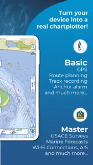
What is aqua map - mobile chartplotter app? Start Your 14-Day Free Trial on All Subscriptions Today
Get the latest charts you can use offline, weather, tides and POIs from ActiveCaptain and Waterway Guide.
Connect AIS and your boat GPS and instruments data via WiFi connection. Plan routes, record your tracks, find new friends on the water and share your data across the Live Sharing community.
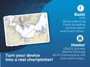
THE MOST ADVANCED MARINE NAVIGATION APP
• Optimised for both iPhone and iPad with multi-screen mode
• Vector and raster nautical charts for offline use, updated regularly
• Satellite image
• Routes/Tracks navigation with real-time information on bridges, hazards, and best fuel prices
• Manual route planning
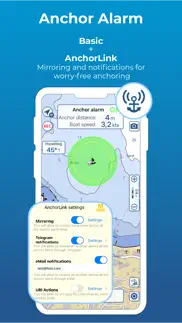
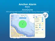
• Basic anchor alarm and AnchorLink with mirroring and email/telegram notifications
• Marine Forecasts for wind, waves, currents and worldwide weather information
• 1800+ Weather buoys to get real time sea info
• Tide & Current predictions and simulations
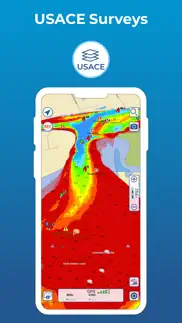
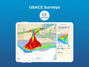
• USACE surveys and USCG List of lights
• 14000+ vector lake maps
• Easy sharing and uploading of tracks, markers and routes
• Live Sharing-Aqua Map community to find new friends on the water
• ActiveCaptain & Waterway Guide community integration
• Real time display of NMEA instruments (depth sounder, wind sensor, compass, GPS)
• AIS target display with automatic collision detection
• Powerful search with advanced settings
• Light/Dark display
• Optimised battery usage
► NAUTICAL CHARTS
Official NOAA charts complete with depth contours, navigation markers, buoys, lights and other chart features. You can download the maps at home on all your devices and use them on the boat offline (no internet connection required).
► ROUTES and WAYPOINTS
Plan your trip, insert and edit waypoints. Navigate your route and your track, monitor distance, time (ETA), course and heading to next waypoint or your final destination.
► ANCHOR ALARM
Set the anchor position and drift radius and monitor in real time. If the GPS position is outside the defined range, an acoustic alarm is sounded and a visual alarm is displayed. Low battery and bad GPS reception alarms are also available.
► TIDES & CURRENTS
You can calculate the prediction for more than 7500 stations in US, Canada, Bahamas & Australia. See the T&C trend on the map and simulate any future date.
► LOADING and SHARING
You can share your favorite's markers on Facebook or send an email with your last daily track. Not only, you can also load any KML, KMZ, GPX found in internet or received from your friends.
► COMMUNITIES
Join “Live Sharing” and become part of Aqua Map community: find new friend on the water, chat and send your data to anyone without leaving the app.
Access tens of thousands of points of interests and reviews all over the world from ActiveCaptain and Waterway Guide communities.
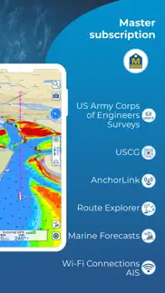
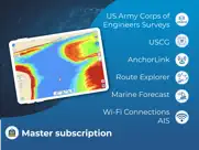
► AQUA MAP MASTER
Transform your device into a chartplotter:
• Most updated USACE surveys and USCG List of Lights
• Marine forecasts (wind, waves, currents and weather)
• AnchorLink with mirroring and telegram/email notifications
• Connect NMEA (and SignalK) devices through WiFi and use instrument and AIS data all across the app (navigation and anchor alarm)
• Display AIS targets on the chart with automatic collision detection
• Route Explorer with real-time information on bridges, hazards, and best fuel prices
(Note: This subscription includes extra features but does not include cartography; it must therefore be paired with a cartography subscription)
► TYPE OF PURCHASES
Unlimited: download and update forever (available only for some subscription)
Subscription: one year auto-renewable subscription. The payment will be made through your (Apple ID) account. The subscription will renew automatically unless cancelled at least 24 hours before the expiration. The user can manage their subscription and turn off auto-renewal in the Apple ID Account Settings section after purchase.
Terms of Service: https://www.aquamap.app/terms-and-conditions
Privacy Policy: https://www.aquamap.app/privacy-policy
😍 Do you love Aqua Map - Mobile Chartplotter app? Please share your friends!

Please wait! Aqua Map - Mobile Chartplotter app comments loading...
Aqua Map - Mobile Chartplotter 37.6 Tips, Tricks, Cheats and Rules
What do you think of the Aqua Map - Mobile Chartplotter app? Can you share your complaints, experiences, or thoughts about the application with GEC S.r.l. and other users?
Aqua Map - Mobile Chartplotter 37.6 Apps Screenshots & Images
Aqua Map - Mobile Chartplotter iphone, ipad, apple watch and apple tv screenshot images, pictures.
| Language | English |
| Price | Free |
| Adult Rating | 4+ years and older |
| Current Version | 37.6 |
| Play Store | gec.MarineApp.WorldViewerLiteHD |
| Compatibility | iOS 12.0 or later |
Aqua Map - Mobile Chartplotter (Versiyon 37.6) Install & Download
The application Aqua Map - Mobile Chartplotter was published in the category Navigation on 15 October 2014, Wednesday and was developed by GEC S.r.l. [Developer ID: 675562886]. This program file size is 135.36 MB. This app has been rated by 9,579 users and has a rating of 4.7 out of 5. Aqua Map - Mobile Chartplotter - Navigation app posted on 25 March 2024, Monday current version is 37.6 and works well on iOS 12.0 and higher versions. Google Play ID: gec.MarineApp.WorldViewerLiteHD. Languages supported by the app:
NL EN FR DE IT PT ES Download & Install Now!| App Name | Score | Comments | Price |
| Aqua Map Boating Reviews | 4.7 | 9,502 | Free |
| Terra Map - Trail Explorer Reviews | 4.5 | 507 | Free |
+ Small improvements to always have the most reliable application
| App Name | Released |
| Citi Bike | 21 May 2013 |
| Blink Charging Mobile App | 08 October 2022 |
| Find my Phone, Friends - iMapp | 26 July 2014 |
| ParkHouston | 05 May 2017 |
| Scout GPS Link | 05 August 2015 |
Find on this site the customer service details of Aqua Map - Mobile Chartplotter. Besides contact details, the page also offers a brief overview of the digital toy company.
| App Name | Released |
| SledNH 2024 | 05 September 2023 |
| MapOut | 19 March 2012 |
| Bronx Zoo - ZooMap | 16 May 2021 |
| IMotoneige | 02 December 2017 |
| Ski Tracks | 05 April 2010 |
Discover how specific cryptocurrencies work — and get a bit of each crypto to try out for yourself. Coinbase is the easiest place to buy and sell cryptocurrency. Sign up and get started today.
| App Name | Released |
| X | 09 October 2009 |
| Lemon8 - Lifestyle Community | 12 March 2020 |
| Uber - Request a ride | 20 May 2010 |
| SHEIN - Shopping Online | 19 May 2014 |
| Telegram Messenger | 14 August 2013 |
Looking for comprehensive training in Google Analytics 4? We've compiled the top paid and free GA4 courses available in 2024.
| App Name | Released |
| Ultimate Custom Night | 28 April 2020 |
| Bloons TD 6 | 14 June 2018 |
| Unpacking | 24 August 2023 |
| AnkiMobile Flashcards | 26 May 2010 |
| Purple Place - Classic Games | 17 May 2019 |
Each capsule is packed with pure, high-potency nootropic nutrients. No pointless additives. Just 100% natural brainpower. Third-party tested and validated by the Clean Label Project.
Adsterra is the most preferred ad network for those looking for an alternative to AdSense. Adsterra is the ideal choice for new sites with low daily traffic. In order to advertise on the site in Adsterra, like other ad networks, a certain traffic limit, domain age, etc. is required. There are no strict rules.
The easy, affordable way to create your professional portfolio website, store, blog & client galleries. No coding needed. Try free now.
Aqua Map - Mobile Chartplotter Comments & Reviews 2024
We transfer money over €4 billion every month. We enable individual and business accounts to save 4 million Euros on bank transfer fees. Want to send free money abroad or transfer money abroad for free? Free international money transfer!
Love It. I guess I’m a bit strange but I’ve always loved maps! This app rocks! It lets me take trips before I actually do it for real! So awesome! Now we finally got our boat and I’ve been using this each time we have gone out. It’s invaluable to have when sometimes the water level is so low and if you are not paying attention to the map, you can run a ground. Many times it’s not about staying the middle of the ICW, you have to pay close attention to where you are at! I love this app and how I’ve been able to plan all our trips making sure we are safe and enjoying the waterways! I”m also very impressed that anytime I’ve asked a question, I’ve gotten a real answer, not a bot sending me links. Great job!
Best tool a Mariner can have. As a professional mariner, I have a few “must have” tools on my iPad that serve, for the most part, as backups for my primary navigation systems. One of them in Aqua Map. Simply put, it is my go-to for route planning, distance measurement, route research, etc. I hear of others who use different tools, but this is my favorite, and think that every mariner should have it at part of their tool bag!
Great for Navigating the Hudson. Looking for a navigation app to help me on my first trip on the Hudson River. I have a runabout without any electronics so thought I’d try finding an app that would be fun to try and hopefully be of some help. I used it for the first time on the water and it worked flawlessly in helping me keep in the main channel. Seemed to be very accurate in marking the hazards and all of the channel markers that I saw along the way. Worked great for me and made my trip much more enjoyable and I believe, safer.
Simple and easy for weekender. I suspect this is a very powerful app. However this is not what I was looking for as I am a weekend sailor and wanted a simple navigational program for sailing the Chesapeake. Tried several other programs that were way too complicated and expensive. This this one was easy to install and easy to use and very affordable. Perfect for what I needed for a week of sailing on vacation.
Syncing, etc. Ability to sync maps and routes across devices doesn’t exist. finding and marking places is like a poor kindergarten version of Google Maps. No routing ability. just a couple icons to mark spots. they seem to be working more on adding shallow checkmark features, then really going deep to provide functionality with a smaller subset of high priority features. it works, and is useful but not great.
Nice work!. I switched from another chart app I was used to so at first, I struggled with Aquamap… though I was also using it on my phone. I switched for access to the Army core of Engineers surveys for the Chesapeake Bay & the connection to the Waterway Guide. Now that I’m working on an iPad & more up to speed with the touch screen optimized layout & controls, I am super impressed!
Great app with great customer support. I have been using Aqua Map for about two months and am very impressed with the many features in the app. Previously I had been using Transas Isailor, Sea IQ, and Open CPN. All three of these programs are good, but I am finding Aqua Map to be much more user friendly and feature rich. As important as the features of the program are, the EXCELLENT customer support provided by The Aqua Map team is essential. I had a problem connecting my external GPS and AIS data to the app. My NMEA settings for these features worked on my other navigation programs, but no matter what I tried I could not get it to work with Aqua Map. After two email exchanges with Pietro from Aqua Map the problem was resolved. Pietro’s responses were accurate and timely, and I came away with the feeling that these guys really care about their product and reputation. Thanks again for your help, and please continue to make your application the best navigation software in the marketplace. Mark
Head and Shoulders Above the Others. Aqua Map is THE mobile app that should be on a tablet on a Ram mount at every helm and on your smart phone. Please go through the built in tutorial. Until I did that, I did not understand just how capable this app is. App is free, best approach to pricing charts. Buy charts (I got “forever” updates) and use on up to five devices. Nobody else even comes close in value. Too many features to list.
Best one. Fast. Free. Easy. Low Battery Impact. Basic plotter I use in Mid-Chesapeake Bay. And I tried a bunch of them. This is the best by far. Even works ok on an old iPhone 6 Plus. I wound up paying the $4.99 for an extra map. Some won’t have to. Otherwise you have to delete and download the next area if on a long transport. I spend lots of time where two map grids meet so I really need two areas. They give you one area of a map grid at a time free. Total bill: $4.99 for the plotter I use more than anything. Again, the one free map you get will work for most people. Best money I’ve spent boating... if there is such a thing!
great for family boating. best of the apps i have used and tried so far, very customizable. ONLY COMPLAINT is when in landscape mode it seems to not track my current location very well it “lets go” of current location center of map.. but constant updates coming in are great, this developer cares.
Game changer. The absolute best app that I’ve found so far for my boating needs. Having used this app up and down the eastern coast and Bahamas I can highly recommend. Aquamap master with a NEMA gateway such as Vesper AIS makes critical information available from anyplace on the vessel. Information equals safety and having that at a glance, for me, is a sound investment in safety. Active captain data overlaid on charts makes using this app a must have for planning and on tbr fly changes when finding dockage or anchorages. To top it off support has been wonderful with any questions I’ve had
Active Captain Included. I loaded this app and purchased charts because SEAiq lost access to Active Captain after the Garmin acquisition. I am delighted to once again have offline access to Active Captain data. It is limited, though. One cannot create new POI’s or add reviews without being directed to the Garmin Active Captain website. Please, developer, add these features. The nav app itself is very good, although screens are slow to load, even on my new iPad Pro.
Good on a tablet or I-Pad. We use Aquamap on an I-Pad with an external GPS (Bad Elf). Works great and is easy to plan routes, up-date etc. I intended on using it as a supplement to our Garmin, but found I like the clarity, detail and size of the screen much better than the Garmin. I now use it as our primary navigation plotter. I can up-date it from my house using our wi-fi and can plan/enter routes while comfortable in my living room or deck or anywhere. ‘Au Kai 25’ C-Dory
Great For Checking. While I generally use dedicated chart plotters as the primary means of navigation, I do use this application to double check my primary systems. I also frequently use the application for planning trips using it’s access to active captain. I have a large memory capacity on my Iphone6s, and have 8 gig of charting data stored on the phone. The application seems to manage this large data base without any issues.
Tremendous Customer Support. I wrote a less-than-desirable review a few weeks ago. I was contacted by AM and they remained engaged until they had resolved all of my issues…..all of which were MY issues, not issues of the app. I now have the most current version correctly installed and I am delighted with every aspect of the app. I am using AquaMaps to navigate the ICW and near off-shore runs. The stress level at the helm has dropped significantly simply because I now have access to immediate, accurate, and actionable information heretofore unavailable on any app anywhere. Thank you Aqua Map!
Easy & Accurate. We’ve been using Aquamaps for three years. It’s my go to for finding anchorages and marinas. I like that it has Waterway Guide and Active Captain within the same app. It’s easy to use and has tutorials to assist with becoming a pro. The added weather with wind and waves is a true time saver!
Best planning, real time charting app!. Aqua Map may surprise you - when first loaded its simple to use without a lot of features enabled. But once you open the menu you can turn on a lot more features as well! The maps are affordable with options to own them for life. The app runs well on iPhone and iPad and you can even use the iPad version on your Macbook when planning an upcoming route.
Purchased but couldn’t use. At the recommendation of a fellow cruiser, I purchased an annual subscription for the Bahamas as a trial. I was able to use it for a short period of time and then kept getting a message that the tutorial period was over. My only thought was that I needed an internet connection to validate my subscription. If that is the case, this app is useless because while cruising, internet access is not reality. Also because I was in the Bahamas, sorting out the problem was not possible. Now back in the US, I want to know what went wrong before purchasing US charts.
Easiest to use and most accurate. Of all the Nav software we have and use, Aquamaps is by far the most accurate and the easiest to use. It’s continuously updated, your questions are answered nearly immediately and any updates you post are incorporated quickly. The App has information and data you can’t find on other nav apps. I highly recommend it.
Good app but tracking is not as good as competitors. Good app; however tracking polling rate is too slow, when maneuvering in tight areas you will have the line cut across objects and land instead of following the actual track of the boat. I wish there was a setting to increase or decrease the polling time. For ocean passages slow poll rate is great, saves on gpx size among other things, but for coastal navigation need to be able to increase polling time to reflect frequent course changes.
Good Boating Chart. Actually a really good boating chart. I always find myself using this over the other apps. I sail around the San Francisco Bay Area. The company also seems to care about its product and it’s users. Customizable useful features. I verrrry rarely write reviews, last one was forever ago. So I’m usually only writing if it’s really good or really bad. This is on the good side.
Charts disappear from iPad. I am on an extended cruise in the Bahamas. I bought the full Explorer Chart Kit for Aqua Maps and installed it in my iPad as a secondary planning tool. I emphasize secondary as it can’t be trusted as a primary for any offshore sailing. Unexpectedly, three times in the past two weeks all of my charts have disappeared with the message o must be connected to the internet. I’ve then had to reload all of the charts. This is dangerous. Internet is spotty on these parts and there is no cell service if you are further than 10 miles offshore. Aqua Maps needs to fix this serious safety problem!
Great support for a great product!. Been using for about a year and the more I use it the more I like it. Pretty easy to use, but a lot of capability so there is a bit of a learning curve. Could have a better tutorial, but tech support has always answered my questions. I also use Navionics, Garmin Blue Chart, and Garmin Active Captain and this one is the best overall.
Great customer support. Had issues sharing purchased charts across multiple devices. Enrico was very patient walking me through the troubleshooting process and resolving the issue. Great product! Especially like the AIS WiFi integration as well as the ability to submit reviews to ActiveCaptain within the app.
Best app. If you are a boater you need to have this app. This app has everything you need as a builder. You could see all of the maps if you just pay five dollars you get to see everything in your area. I recommend this to all boaters and even if you are not a boater and just want to learn more about the water you should definitely get this app or recommend to anybody.
Everglades trek. Just completed 5 day canoe trek in Everglades National Park from Everglades City. AquaMap was tremendous, performing accurately using GPS and downloaded maps, without cellular or internet access which are not available. AquaMaps was the navigation system that allowed us to do this 55 mile trek though innumerable mangrove islands. It is a great system that is most appreciated.
Emergency download. On our way to Lahaina from Oahu, we got beat up and had an electrical failure and lost our GPS, amongst many other things. It was Hectic and was about midnight next to Lanai. I downloaded this app, got the free map at Lahaina, which has a tiny entrance with many mooring balls before the first buoy marker. This free app got us in safely. 75’ Sunseeker Yacht. I absolutely love this app. I will download this app for future trips, but my only question, is if I download it to my iPhone, can I also use this app on my IPad without having to pay a separate subscription for my two devices. Hope to hear from you. Mahalo. Highly recommend.
The best available. Been using for over a year. It really is the best available. The only feature I wish it had was auto-routing to use for distance estimation. The consumption of the army corps of engineers survey data is fantastic. The new anchorlink feature is now my favorite method of tracking my boat while ashore.
Great value. I’ve been using this app for over five years and have logged well over 2000 inland and coastal miles, plus local sailboat races. The features get better and better. One really great feature is the link to the US Coast Guard local notice to mariners so you know recent nav changes. I use other nav apps as backup but this is my go to app.
Maps not coming up. My wife and I recently purchased AquaMaps along with the maps for the Bahamas. We were on a leg of our journey and when I tried to zoom in on the maps,it said maps not downloaded. I waited until we were close to land and downloaded just that section again,but once again,it said the maps weren't downloaded. So we ended up using Navionics maps which are notoriously inaccurate in the Bahamas.
OK not great. Use the app for Explorer charts. While the price for these charts is good, the detail leaves a lot to be desired since the charts are Raster scans instead of Vector. This means you are restricted to meter depths and no additional detail when zooming in. The Explorer data is good for suggested routes and locations of services cruisers are interested in such as anchorage data, grocery stores, dinghy docks, etc. The app interface is also not intuitive leading me to go through the tutorial often to find how to perform simple navigation tasks. Buy the app for the chart data, not the interface.
Does well. I have used this program for thousands of miles of boat trips. It has excellent charts, great search engine and access to useful reviews. The only thing missing is routing for estimates of time and distance of trips. I have to use Navionics Boating for that function, though Aquamaps beats Navionics in all other categories.
One of the best!. I am relatively new to sailing and have been experimenting with several navigation apps. I can say without doubt that Aquamaps is the best for me. Not only functionality is great however. What really stands out is the support I have received. I almost without fail get replies to my email inquiries in less than a day ( I am on east coast of US). Professional group. I highly recommend this app for all boaters especially those traversing the ICW on east coast of US.
Accurate and easy to use. I’ve used Aqua Maps for five years and have found it to be as accurate as the expensive chart plotter maps. I have compared Aqua Maps on my iPad to my expensive Raymarine CP and I like the ease of sitting in the cabin plotting a route to standing at the helm. Great product!
Great navigation program. Used this for years Great program only problem seems to be getting it onto a new device when I get one . That is always seems to be a hassle
Aqua Map is a fisherman’s friend. Wonderful app making it easy to use navigating waters everywhere. I’ve used this app for several years, and there is little use for any other tool as a fisherman. Great graphics, easy to change font sizes, empirical and metric measurements. The only downside is I’ve seen no new lake maps added such as Lake Wawasee (largest natural lake in Indiana).
Used by professionals. Aqua Map surpasses all other available options. I use this tool when operating as a Sea Tow captain to help identify best possible routes for getting to grounded clients due to the integrated USACE survey data as well as the satellite views of the waterways. I also use it when teaching new captains during our classes for merchant mariner credentials at the Carteret Community College in Morehead City. As a professional, I rely on quality tools and the opportunity to help influence features to a willing and listening development group!
Impressive integration. I had heard of Aqua Map for several years as an ‘alternate chart’ for cruising on the Atlantic ICW. Finally bit the bullet after it was recommended strongly by a 10 year vet of the ICW. Wow! This is the best chart for detailed routing depths and integration. An absolutely must have. This with a paperback version of ‘2020 ICW Cruising Guide’ by Bob 423 and you will save countless headaches and mishaps.
Outstanding Integration. As one of your first users of Aqua Map many years ago I am writing to thank you for your wonderful application and its integration with and continuing relationship with Waterway Guide! Hopefully with the ease of integration more and more users will take the opportunity to provide crowd sourced information for anchorages and marinas! Active Captian was a wonderful source of information but no more as it is woefully out of date. I hope and implore all Aqua Map users to actively provide updates to Waterway Guide through Aqua Maps! Let us all make both the invaluable tool for updated information while cruising.
The best of the best. I love Aqua Maps. I can’t say that enough. I have been accused of getting a kick back from Aqua Maps because I tell everyone how good it is. I have personally turned over 20 people on to it. I started out in Lake Michigan over a year ago and wanted to use ActiveCaptain for our up coming trip. We had been using it for years and I have a lot of reviews on it of our old cruising grounds but then all the issues came up with Garmin. Three days before we left to head down Lake Michigan I found Aqua Maps. This is one great chart plotter. We use it for all our route planning and as a second chart plotter in the cockpit. The charts are spot on and have not let us down in over 4 thousand miles of ICW to Bahamas cruising. Works great and at a very reasonable cost. We still let everyone know about it. Would not be without it.
The best!. I use iNavX and Aqua Map. One uses raster charts and the other uses vector charts. They are the best of the best (I also have a Garmin dedicated chartplotter). Of the two, Aqua Maps is easier to use, gives more information (especially with the USACE overlays and the Active Captain data), and is less expensive to load up with charts that cover the whole US and Canada. Update: After several more years and a few thousand more miles, AquaMap is still my favorite.
Way better than my Garmins!. Better detail than my Garmins and my phone is tougher and more weather proof than any Garmins I’ve owned. Also Aquamap continues to update and service their platform. Garmin quits repairing and updating their modules when they get older. Glad I found Aquamap.
Great navigation app!. Used this to go up and down the East Coast five separate times. The app got more powerful and more featured and I got better at using it and I marvel that the first time I went to Florida in my boat I even made it without this. I use this with my iPad at the helm and I also have it on my cell phone and I am continually impressed.
Not impressed so far. Edit to previous review: After I figured out that my cell signal just wasn’t good enough (worked for everything else?) I was able to get the maps I wanted to upload after moving to a different spot. The next day I did receive a response via email from customer service. Can’t really vouch for using the app yet. Raised from 1 star Previous 1st time review: I decided to pay for an upgrade to try it out and maps won’t download in areas I paid for. Sits there saying it’s downloading, then after having to wait for it to do so, it places a pop-up saying some maps didn’t download properly check storage, no other option. Check storage and there’s almost 200 GB available. Are the maps really that large?
Must-have navigation tool with intelligent features and great customer support. This is a must-have tool for those of you who are serious about boating and venturing into unfamiliar waters. The app provides so much useful information it makes navigation so much safer and easier. It covers bridge clearances, weather, tides, current, even fuel prices along your route. And if you need help the customer support from senior management is excellent and responsive. The tool and data just keep getting better. I’m 1200 miles from home in totally new places and I use it every day.
Great but. I bought Aquamaps for the Bahamas Explorer charts. They are excellent. Unfortunately, after my year one subscription was up the Explorer charts disappeared. They shouldn’t disappear, they simply shouldn’t update to the newer charts. Now all my Bahama data is worthless without the old charts. I hate to say this but Navionics charts don’t disappear when the subscription is over.
Excellent navigation tool. Aqua Map combines a clean interface (clear vector charts, auto full-screen view, easy chart downloading, & more) with useful navigation tools (simple distance/bearing "dividers," easily editable waypoints, and—the best—MAGNETIC bearings!). After sailing and motoring with several iPhone apps, this is my new go-to companion for on-deck reference. Plus, customer service has been prompt, personal, and valuable.
Active Captain missing data. I use this app primarily for access to Active Captain. It seems like a good replacement for Blue Charts which is no longer available. It works very well for finding Active Captain reviews - the charts are clear and nicely detailed, it's easy to use - unfortunately, not all the Active Captain data is displayed. For anchorages, it is missing the ratings section and the sections called Dock, and Services. If it had the missing data I would give it five stars.
Disappearing charts, but great features. This app has become my go to after losing Garmin BlueChart. The features are great with the along route info on bridges, fuel stops etc and the USACE sonar survey overlay is an amazing tool! BUT, despite ensuring the button in settings is off for delete charts in case of low available space my charts continue to disappear from two devices, but more obvious on my phone than tablet. Wrote to tech support and was dismissed as the button being my issue. It is certainly not on and I continue to have my charts disappear or require downloading 4-5 times before the tiles stop showing update in the corner. This app is on track to be great, but is currently unreliable.
Wow this is a perfect app for my region in Alaska. I have fished and hunted my whole life in Alaska. I tap on a region and download it. I live on an island in Alaska , only way to get in and out is by plane or boat ! This app is perfect for my region or any region in Alaska for that matter. Thank you for making an app available to people who live in the areas in America that are off the charts!
Did you know that you can earn 25 USD from our site just by registering? Get $25 for free by joining Payoneer!
Looks good but overlay broken. Good details on maps but zooming in gives you a mix of raster and vector maps in overlay which makes the app virtually useless. Fix this please.
Scammers. What a scammer, you need to purchase the maps at $29 for 14. Days trial,
Excellent Navigation Tool. Aqua Map navigation software is an incredible navigation tool. Comprehensive charts, precise navigation tools, and real-time updates ensure smooth sailing every time. The interface is incredibly intuitive, making it easy to plan routes, track my progress and explore new destinations with confidence. Aqua Map sets a new standard for marine navigation software. Pietro and his team’s provide a level of customer support that is absolutely outstanding. I highly recommend Aqua Map to anyone hitting the open water.
Great user interface - poor chart alignment. Where RMS maps are overlaid on top of the native chart, the alignment is often very inaccurate. I would prefer to be able to toggle the RMS maps off (similar to satellite view). I’ve commented on this before and it still hasn’t been fixed.
Imagine you at your best. All the time. Picture yourself at your sharpest and most productive. Your most alert and focused. Your most lucid, creative and confident. At work. At play. In every area of your life. Add Mind Lab Pro® v4.0 to your daily routine and uncap your true potential. Buy Now!
Great app. Use it for fishing in places where you have no service that’s my favourite part about it no need for a gps anymore
Satisfait. Cet application est d’une simplicité et une fiabilité appréciée. Merci. Mario Allard 👍
Les milles-iles, ontario. Merveilleux souvenirs enregistrés.
Aqua Map. Map display is uncluttered and easy to read. USACE surveys very helpful in navigating the shoals on ICW.
manque. manque trop de détails aucun rapide inscris pour le riviere
Thumbs down.. Navionics is a way better app.
Deleting this app. Doesn’t work properly. I couldn’t get it to recognize that I was in the water, my boat icon in the app never moved from land even though I was in the water the whole time I was using it. Useless.
Easy and accurate. Very intuitive to use, tracks are easy to follow.
Incomplete charts and can’t stop subscription. I found on a recent trip on Lake Huron Canada that we were suddenly off the chart in spite of downloading the correct tiles before the trip. There are gaps in the coverage. Also very disturbing I can find no way to stop the automatic renewal of the subscription to the chart. After trying it ‘free’ for 14 days it is about to charge my card.
Mise en évidence des reliefs. Certaines cartes ont des lignes au dessus des basses eaux (sort de l’eau avec la marée) qui ne sont pas de couleur différente aux autres mesures de profondeur ce qui peut mettre la confusion
Rubbish. Completely un usable in Canada Montreal ottawa Kingston toronto to Lake Superior. Only using charts out of date and free from GoC other services offer these free don’t waste your time!!! Response from manufacturers does not resolve the fact that it is rubbish… blaming that on bad Fed data, decades old does not make this an acceptable tool. While I believe YOU had to pay, WE do not as they are freely available because they are so Old..this could easily resolved if like google you uploaded and pooled data from users… product remains Rubbish for Canada.
This app is awesome. I love this app. Boating in new areas is a breeze with this app. The stress of boating in the dark is greatly reduced when using this app. Total thumbs up.
Lake not there. I can’t say it’s a bad app. the lake I’m looking for is not available. I’m trying to cancel the trial but it’s not in my subscriptions!? Can you help me with this? Thanks
Crashes when editing routes. Please fix. When I edit a route, the program closes.
Excellent. Great full function marine chart plotting software. Easy to use. Well designed and functionality is easy to access. If there’s one thing I love to see is VMG to a waypoint calculated and displayed. I have used the app for 2 full seasons now
problème. Seul les grand lac sont bien définis dommage
So so. I downloaded this for a chart of my local lake but the chart quality is horrible can’t read any depths, looks terrible zoomed in. It does have a red rectangle outlining the lake maybe there’s a problem with that particular chart.
Great app. I spent the last two weeks navigating lake Muskoka and Rosseau and this app was an essential tool. It’s easy to use and has informative tutorial to get you started quickly. I liked the route function and the record route function. All buoys are accurately marked and we were able to avoid shallows and negotiate narrows very easily. We did a lot of traveling from point A to B so it would be nice if it had a feature to suggest the fastest route.
Problème avec IPad. Pourquoi votre application ne fonctionne pas avec mes 2 iPad?? Juste avec mon IPhone. J’ai acheté un nouveau iPad hier et ça ne fonctionne toujours pas? Que doit-je faire??
Great. Great App very detailed.
Excellente application pour la pêche…. Excellente application permettant de télécharger les cartes nautiques et les utiliser offline. Plus facile à utiliser rapidement pour la navigation qu’un GPS de bateau.
Best fishing guide, best technical support!. I use this app for fishing, it helps me find where is the best location to fish, can be used without internet. Spoke to the tech support a few times, they are very helpful.
Greedy devolopers. For that ridiculous pricing you can buy a actual marine gps with all functions!
Meilleur source de cartes. Martin: I have on board Garmin, Raymarine (Navionic) and Aqua Map. This last one, is the most acurate of all. It is also the most easy to use when it’s time to make the itinary. I recommand strongly this app.
So far so good. Wondering why my downloaded map of the BVIs has 2 different looks.
Just great. I used it for backup and now it’s my go-to app for the Bahamas.
GPS inaccurate. The GPS could not even place me in the correct lake. It was so far off I had to look up the name of the lake where it placed me - 62 miles away. It was an absolute waste of $18.99 subscription price.
Good charts. It has all the nautical charts for the lakes and rivers in Ontario, Canada. I use it primarily for fishing trips. The maps need to be downloaded in sections before using. I tried it on iOs 9 (iPhone 4s) and iOs 11 (iPhone SE) and it works flawlessly on both devices. Not many useless bells and whistles (like finding “friends”) which is a positive thing. I compared it to a few other apps , but either they didn’t have the charts for the rivers and small bodies of water, or they were significantly more expensive. I wish it was not subscription based but a full purchase, so it loses a star for that.
Adsterra is the most preferred ad network for those looking for an alternative to AdSense. Adsterra is the ideal choice for new sites with low daily traffic. In order to advertise on the site in Adsterra, like other ad networks, a certain traffic limit, domain age, etc. is required. There are no strict rules. Sign up!
Great resource. Great resource for route planning and possibly a back-up. thank you for fine product.
Just downloaded bought a map, just crashes. Ouch. Just bought this, tried using it after downloading Florida maps and all it does is crash. Even rebooted, same thing. Does anyone bother to even test apps before publishing anymore? Was in the middle of trying to get a distance for a track when this thing lost its balance. Unfortunate 1st impression
Aqua Map is the BEST!. We are doing the Great Loop, having started our journey in Hilton Head, SC & currently in Michigan, we’ve traveled nearly 2,500 mi using Aqua Map exclusively. Quick, easy, accurate, and we love having wind and wave forecasts displayed. All this at an incredibly low price. Can’t beat it!
What the heck??. Whatever they did to this app has ruined it!! My boat icon jumps all over the place on both my phone and I pad.
Love this app. We joined freedom boat club and have visited 6 different marinas this year. It’s great to have access to maps of the US. Many of the boat club boats do not have full charting. Many Garmin plotters do ocean or inland but not both. Love it.
Just OK nothing more. This works but, a bit messy for my taste But does work They tried to bill me even though I canceled my subscription. Buyer beware of this type of activity with over billing with this company.
Fishing in Cedar Key area. If you do not have a GPS system on your boat, this app is very helpful. This app has helped us find points, drop offs, and channels with ease. It’s probably the most useful app I have.
Beautifull Charts. Beautifully presented nautical charts. Very fine work. I would find it very helpful if the names of rivers and creeks were displayed more prominently. I recommend this app and charts for all maritime navigators.
Value. While driving our boat up the ICW our Simrad chart plotter died. Aqua Map saved our butts. Great app whuch along with Waterway guide made our 1000 mile journey much safer and relaxing. Wont leave port without it.
Aqua Map. A priceless app. I have a Garmin and Axiom 7 on my boat but find I am using Aqua Map more frequently than the other two expensive electronics. For the price Aqua Map is a perfect investment.
Outstanding.. Outstanding. Once one takes time to understand how to owe the charts and the extra work put into navigation options, one will be hooked.
Really stepped up it’s game. I seldom give 5 stars but this latest change which allows you to change text and symbol size is really significant for me and puts Aquamap far ahead of it’s competition including Navionics. Congratulations Aqumap!
5 Star Customer Service. Received answers to questions same day. Very intuitive program. Graphics are superb. Interfaces easily with Active Captain and then with my Garmin Equipment.
First observation. I am new to this app, but not to nautical charts. Though the graphics are nice, the help is a bit obscure. Perhaps with use I will become more comfortable with the screen navigation
Great navigational tool. We have been using Aqua Maps for the last 4 years. It is a great navigational tool especially helpful on the ICW.
Invaluable for deeper drafts. Saved our kiesters going through McClellanville with our 6’6” draft. Wish we had installed it in North Carolina; would have saved us a SeaTow on the Pungo Canal.
Search and rescue. I work with the Coast Guard auxiliary. When we need to find someone who is in trouble or just simply needs assistance, Aqua Map is wonderful giving us the ability to find them. Thank you for your professional assistance.
Pleasantly surprised. A product that met and exceeded expectations. I used it for first time on a 6 day cruise on the upper Chesapeake, love its functionality and ease of figuring it out. Someone has done their homework in designing this, thank you and well done
Many areas that you can not load. After paying for the subscription I immediately realized that the lake I wanted it for is greyed out and you cannot download it. I requested a refund but was declined. I guess you need the money more than me. Sad
What th’?. This app got me a thousand miles down the AICW. I downloaded the new version... and it’s just CRAP! Come on you guys, how can you mess up so many things in one revision? Boat icon is now off the track, mile markers are shrunken and illegible, my markers have disappeared, the screen takes a serious effort of touching and long presses to display info (like the drawbridge ahead that I need NOW! Please fix this stuff! I can’t believe I paid money for this travesty! Thanks
Aquamap issues.. Lots of good features, but boat icon freezes and does not show current position making Aquamap dangerous to use. After 4 contacts with technical support the problem is not resolved. Live voice support is not offered. Recommend using another app for navigation.
Looking for a replacement for Blue Chart. I took the advice from a reviewer I had agreed with when I was looking to replace the abandoned Blue Chart. I’m still trying to learn how to use it effectively but have found info online from several sources. I’m happy so far and think I’m going to like it.
A lot more functionality than 2019. Aquamaps is indispensable in the Bahamas and has many benefits on the ICW. So many features are very user friendly. Like the AIS interface for one. I still use Navionics in US waters because of their SonarCharts. I use SEAIQ for offshore. I don’t see replacing either with AquaMaps, yet.
Better than my chartplotter. I have great faith in this app. It has saved my boat several times when my chartplotter was disabled. I use this and CP simultaneously at my helm all the time. The improvements keep getting better and the customer support is outstanding.
Best. This app is better than any program I have paid hundreds of dollars for. Aqua Maps should teach Garmin a few things.
Can’t update, not user friendly. Well, to view Explorer Charts, a great tool, but it stops there. I can’t download or update on my iPhone or iPad - I get a message telling me to check my storage - I have 88G and I’m trying to load a Leadley 300MB. Takes hours and then errors. As for ease of use or nav data while a route is active - there are other apps out there that actually do that! Not this one.
Aqua Map. I have found it about impossible to learn how to use this map. I need a simple list of steps that lead me to the basic functions with the basic program. No explanations where they are needed. It does look very handy, but I’m lost so far after a week or so.
BUYER BEWARE!!. Better go check the area you want on the website before you pay. “North America” is a huge generalization. Most of the medium size lakes and half the states are not available. You won’t know this when you buy it for $20 but you sure will when you realize you can’t download you area. Entirely useless for a huge amount of the lakes in the US.
Great Lake depth app. I just started using this app in 2020 to see where the deep holes are in the local lakes. I’ve used it in a boat and while I’ve fishing. Not only has it helped me find some amazing spots to fish but also helped me navigate add the lake safely after dark. If you love to fish this is almost a must have app.
The most up to date information!. Metadata is phenomenal. USCG LNM updates are updated on the app within 1 week.
Valuable tool. My husband and I are traveling on the AICW / Great Loop. I have Aqua Maps on my Apple IPad, I like to be able to track our boats position when moving the boat. I use Bob423 along with my Aquamaps. Such a valuable tool to have aboard.
A1 app!. The guys at Aquamap have done it right from the beginning. Always staying up on the needs of the boating community without gouging for top dollar. I continue to use these great apps and look forward to future updates with great anticipation. Support is unmatched. Thanks.....
Best ever. I learned nav at the USCGA in the early 70’s with a sextant and HO249. I’ve tried most every new thing that came along to avoid mud and rocks but Aquamap is by far my favorite. The USACOE overlay makes the ICW fun even with a 6’-5” draft at low tide.
New to navigation. It took me sometime to set this up . It required the purchase of a new iPad with cellular service then setting up the cell service. It is reasonably easy to learn . It’s very clear and easy to understand.
Great product!. I just took a two day trip from Northport AL all the way down to the coast. This app helped greatly. Would not consider going without it!
Best Navigation App. Started using while on the ICW and probably the best marine navigation app I’ve come across. Having the latest USACE data for the ICW was fantastic.
My go to navigation app.. Waterway Guide links are especially useful. Also easy to update when connecting to WiFi.
Great Nac App. Aqua Maps has been my “go to” Navigation App for several years. We have traversed the east and west coasts of Florida as well as multiple trips to the Bahamas. I love the app!
Game changer. I have said for sometime that AquaMap is and has been a game changer. No other app has the features and support for users. They are far out in front of the others.
Used them all, this is the best. Hands down most accurate and functional map tool for cruising
Best Boating app ever. I’ve been using this app for the past few years and nothing else comes close. They continue to improve on the app functionality and imported features and data. I’d never be without it!
Best navigation app I’ve found yet.. This is better than iNavX and navionics in my opinion. This is easy to use, you spend less than $20 to make this a really accurate, intuitive, REAL TIME chart plotter. Can’t wait to use it out on water.
Highly Recommend. Accurate and easy to use. Thank You.
New update is buggy!. I adore Aquamaps, but the new Marine Forecast update now causes it to crash whenever I touch an icon (such as Active Captain) for more information. Also, there should be information in n the website about the new update!
Great Chanel chart app. I have been working with Aqua Map‘s now for a couple of years in cruising South East Florida waters. It’s very easy to use and has many useful options.
Great capability app!. I run both Aquamaps and Navionics while cruising. The additional capabilities of Aquamaps (wind, current, etc.) make it my default nav app at this time. Great app and easy to “navigate”.
Best Program Ever. This program is way better than Navionics. I have taught classes on Navionics and I can’t tell you how much better this program is than Navionics. One request that I have is Auto Routing on this program. Congratulations Aqua Maps YOU ARE THE BEST!!
Use for Active Captain access and planning. Each app has its strong points. I use this app mostly for planning and for AC access. In some areas, like in the USA AND Canada I would feel OK using it for navigation. But no app is completly perfect and this is a lot of bang for the buck. I use it a lot, more than I thought I would.
Useless. They killed off the Aqua Map version and requires you to update to this version. Tell you to register which I previously did in the old app, then login and your purchases will transfer. Well when I try to login the app says no such email is registered, when I go to reregister it says email already exists, basically a catch 22. App isn’t that useful, I won’t be renewing.
Love this app. Better than Navi@nx. Short sail up to Sarasota Bay. Charts on Nav were so off. I quickly downloaded this app and wow! I’m so impressed. From bridge information to anchorages, everything was actually accurate!